 +1 credit
| Version | Summary | Created by | Modification | Content Size | Created at | Operation |
|---|---|---|---|---|---|---|
| 1 | CEZARY KOWALCZYK | + 555 word(s) | 555 | 2021-01-07 09:00:09 | | | |
| 2 | CEZARY KOWALCZYK | + 117 word(s) | 672 | 2021-01-19 12:54:15 | | | | |
| 3 | CEZARY KOWALCZYK | + 141 word(s) | 696 | 2021-01-19 13:01:01 | | |
Video Upload Options
Geographic information systems (GIS) are composed of software, hardware, data, administrators, and methods for processing and analyzing data. Creating and sharing spatial data in digital form is not only good practice but is also regulated by specific legal acts. Currently created in map portals and the widely available General Geographic Object Databases offer a reliable, current, and continuous source of spatial information for the entire country, extremely helpful in the planning process at various levels of generalization. The database implemented into the Spatial Information System is its most important element and should constitute a complete and reliable representation of elements of the real world.
GIS systems allow us to formulate models in a structured and formal way to reflect both the current situation and forecast changes that will occur in space when certain conditions are met. The proposed methodology can be used in practical applications:
• Preparing planning studies, both regarding spatial policy and local law, as well as in economic planning and shaping the structure of rural space (structure of ownership and structure of use).
• The development of thematic spatial information systems related to planning studies and works shaping the rural space.
• Reports submitted to EU authorities relating to the utilization of funds dedicated to rural development in the multiannual financial framework and modification of the implemented actions.
• The use of renewable energy sources to improve Poland’s energy security.
1. Introduction
Geographic information system (GIS) is a highly useful tool in the decision-making process in the domain of physical, social, and economic space. GIS tools support the acquisition of spatial data from various sources, rapid processing of data, and the release of data in the desired form for multidisciplinary analyses, studies, and forecasts[1]. GIS tools are used to collect, gather, edit, process, update, and release spatial data. They are most useful in the process of acquiring input data from various sources with the involvement of different methods and techniques, beginning from crude field data and moving to fully automated data acquisition systems that do not require human involvement. Data from various sources are processed to generate new information and products[2].
2. Function
The main functions of GIS are the collection, verification, accumulation, integration, processing, and release of spatial data (information about geographic space). Users can combine descriptive data with information about the spatial location of the analyzed objects; they can generate thematic maps, conduct spatial analyses, and formulate conclusions. These functions are shown in Figure 1.
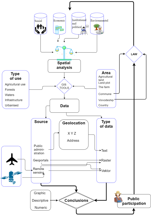
Figure 1. The scope, sources, and applicability of data for spatial analyses. Source: own elaboration.[3]
Geographic information web portals were also a useful source of data for analysis. Data generated by Web Map Service (WMS) servers were used to create raster layers on the map of the analyzed objects, which supported detailed evaluations. Various types of data were processed with the use of appropriate tools and methods.
The main principles for using spatial data and spatial analyses in the sustainable development of rural areas. The main research objective entailed the following detailed objectives. The procedure involved several steps, presented
in Figure 2.
• To determine the scope, sources, and applicability of data for spatial analyses of phenomena relating to sustainable development.
• To identify the determinants of rural development in view of the main pillars of sustainable development.
• To determine the optimal directions of sustainable development in rural areas.
• To propose a practical approach for the use of spatial tools, methods, and analyses and to develop theoretical and practical procedures for the sustainable development of rural areas.
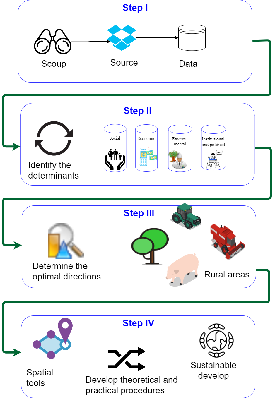
Figure 2. The procedure of using spatial data and spatial analyses in the sustainable development of rural areas. [3]
The Geographic Information System supports the integration of various types of data obtained from numerous sources and stored in different formats. The quality of the collected, processed, and released data is visibly improved. The resulting information is easier to find and interpret, which supports the formulation of accurate conclusions. Various types of spatial data and databases can be processed with the use of GIS tools[4][5].
GIS tools continue to evolve, which improves access to information and increases database managers’ awareness that highly accurate data are needed for spatial analyses.
References
- V. K. Bansal; Use of Geographic Information Systems in Spatial Planning: A Case Study of an Institute Campus. Journal of Computing in Civil Engineering 2014, 28, 05014002, 10.1061/(asce)cp.1943-5487.0000296.
- Elżbieta Zysk; Agnieszka Dawidowicz; Sabina Źróbek; Ryszard Źróbek; The concept of a geographic information system for the identification of degraded urban areas as a part of the land administration system - A Polish case study. Cities 2020, 96, 102423, 10.1016/j.cities.2019.102423.
- Krystyna Kurowksa; Renata Marks-Bielska; Stanisław Bielski; Audrius Aleknavičius; Cezary Kowalczyk; Geographic Information Systems and the Sustainable Development of Rural Areas. Land 2020, 10, 6, 10.3390/land10010006.
- Kurowska, K.; Kryszk, H.; Kietlińska, E.; Photovoltaics as an element of intelligent transport system development.. Geoinformatics for Intelligent Transportation 2015, 1, 187–199, https://doi.org/10.1007/978-3-319-11463-7_13.
- Brodziński, Z.; Kryszk, H.; Kurowska, K.; Market of producers and processors of agricultural biomass for energy purposes. Polish Journal of Environmental Studies 2014, 23, 619–628.


