1. Introduction
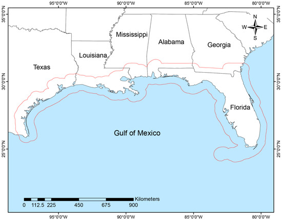
The United States (US) Gulf of Mexico Coastal Region (GCR) contains a vast and diverse natural landscape, which includes coastal wetlands, submerged vegetation, bayous, uplands, and offshore marine areas (). Encompassing more than 700,000 square km, the GCR harbors over 15,000 species of flora and fauna [
1]. This biodiversity is a product of the breadth of ecosystems represented within the GCR landscape. The five adjoining states in the GCR, including parts of Alabama (AL), Florida (FL), Louisiana (LA), Mississippi (MS), and Texas (TX), are also places of rich culture and great natural beauty, with deep socioeconomic ties to the abundant natural resources in the region. Since natural and societal values depend on the ecological richness of the region, conservation is a shared priority among many GCR stakeholders. However, years of ecological degradation [
2,
3,
4,
5], including the effects of the 2010 Deepwater Horizon disaster and oil spill, have increased the vulnerability of resources within the region.
Figure 1. Overview of the Gulf of Mexico Coastal Region (GCR) along the U.S. Gulf of Mexico. The GCR includes all of the coastal counties, plus 40.2 km inland of the coast including the barrier islands as shown in red outline.
The US has a long history of practicing land conservation at all levels of government resulting in a robust network of protected lands in the GCR [
6]. However, a persistent conservation planning challenge is the identification of optimal lands in need of protection and subsequent prioritization of those areas based on ecological and socioeconomic valuations. As it is not possible to protect all the land worth protecting within a region at the same time, a strategic approach must be used to identify the most effective lands to conserve relative to ecological and socioeconomic goals [
7]. However, substantial lands remain vulnerable to conversion, and, to date, there is a lack of comprehensive analysis of land conservation planning efforts across the entire GCR geography to improve strategic targeting of land conservation efforts. A holistic understanding of the extent and focuses of existing conservation efforts in the GCR will help planners direct appropriate conservation actions in the future. With private land ownership dominating over 86% of agricultural and forested lands in the GCR, conservation and management decisions involving private landowners has a significant impact on the region’s environment and economy [
8]. Proactive engagement with state and federal agencies, private landowners, local communities, and nonprofit organizations that actively conserve land via joint agreements with landowners, direct land purchases, and other methods will be paramount to create a sustainable future for the GCR.
In response to the Deepwater Horizon oil spill of 2010, the US government acted in concert with states to implement coordinated efforts to restore the ecosystems and economy of the GCR. Included in the federal response is the Resources and Ecosystems Sustainability, Tourist Opportunities, and Revived Economies of the Gulf Coast States (RESTORE) Act, signed into law in July 2012 [
9]. The RESTORE Act created the Gulf Coast Ecosystem Restoration Council (Council) and the Gulf Coast Restoration Trust Fund (Trust Fund). The RESTORE Council consists of 11 members, including leaders of six federal departments and governors of the five Gulf Coast states. One of the Council’s responsibilities is the development of a comprehensive plan for the restoration of the Gulf Coast. The Trust Fund is responsible for obligating 80 percent of the Clean Water Act penalties generated from the oil spill with the funds going towards accomplishing goals and objectives identified in the RESTORE Council’s comprehensive plan [
10]. These goals include Restore and Conserve Habitat (Habitat), Restore Water Quality (Water Quality), Replenish and Protect Living Coastal and Marine Resources (LCMR), Enhance Community Resilience (Community Resilience), and Restore and Revitalize the Gulf Economy (Gulf Economy). For clarity, we will hereafter refer to each RESTORE goal in the text as they appear in parenthesis in the previous sentence. The Strategic Conservation Assessment (SCA) project, funded by the Department of Interior (DOI) via the Council Selected Restoration Component, is focused on developing science-based conservation planning support tools using the RESTORE goal framework to maximize the effectiveness of land conservation investments. In this work, one of these tools is presented that catalogs existing conservation plans in the form of geospatial visualization.
A holistic understanding of the origin of conservation plans and their relationship with respect to RESTORE conservation goals can be useful in understanding and aligning conservation planning efforts to funding opportunities associated with land conservation in the GCR. Similar comprehensive analyses of conservation effort have been conducted in Australia and Europe [
11,
12]. The outcomes of such research found an uneven representation of habitat protections across their respective regions and characterized the frequency of conservation at different planning extents. While our study has a similar vein of analysis, it is distinguished by our characterization of conservation efforts within the framework of the RESTORE goals which represent the shared priorities of the GCR. We focus on the RESTORE goals framework because of the unique opportunity to fund conservation efforts from the influx of funds from settlements related to the 2012 RESTORE Act. The product of this study will thus summarize how land conservation across the GCR has addressed the RESTORE goals, with the intent that it will help illuminate and guide appropriate conservation actions that provide adequate protections for the region’s diverse landscape, species, and economic activity.
In this study, we compiled and reviewed an extensive inventory of conservation plans in the Gulf of Mexico—from local to regional (i.e., GCR) levels—to catalog priorities identified and efforts undertaken with respect to land conservation. With respect to RESTORE goals, we expect plans to more frequently address Habitat, Water Quality and LCMR. Whereas socioeconomic goals such as Community Resilience and Gulf Economy are not typically addressed through land conservation, we therefore expect these goals to occur less frequently. This study is the first large-scale regional assessment of conservation planning efforts across governmental, nongovernmental, and nonprofit organizations encompassing all ecosystem types in the GCR. This comprehensive analysis is vital to understanding the key factors that may drive existing conservation efforts, as well as identify potential gaps in conservation planning efforts.
The contributions of this study include
-
a catalog of conservation plans and projects in the GCR at multiple levels of the jurisdiction from 1998 to 2018;
-
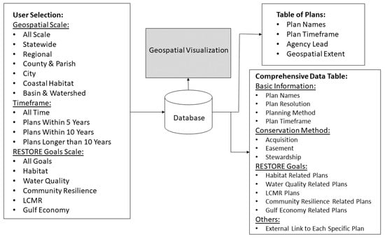
the development of an online geospatial tool for exploring conservation plans in the GCR; and
-
an assessment of how conservation planning at various political and geomorphological subregions within the GCR associates with the RESTORE Council goals.
2. Materials and Methods
2.1. Scope of the Study
The SCA region of interest aligns with the RESTORE Act-identified GCR, an area of approximately 700,000 square km (). The GCR encompasses coastal parts of AL, LA, MS, TX, and all of FL. This geographic extent was created using the coastal management zone area in the five Gulf states, plus a 40.2 km inland buffer. Some of the plans within the catalog extended outside these limits but were included if benefits directly occurred within the SCA region.
2.2. Method for Cataloging Plans
To represent the breadth of planning scales, the conservation plans were categorized in three ways: by (1) individual states in the GCR; (2) political and geomorphological subregions (); and (3) the goals identified by the RESTORE Council (). Some plans extended beyond an individual state and were grouped as GCR plans in lieu of belonging to an individual state. The plans were also grouped by political and geomorphological subregions because of the importance of planning scale towards achieving conservation objectives. Plans with political boundary classifications (i.e., city, county/parish, region (within the state), statewide, and GCR), were developed by the representative political entity and incorporated some land conservation actions. Regional plans had focal areas of two or more cities or counties/parishes within a state and GCR plans had planning scales that spanned multiple states within the GCR. Geomorphological classification scales included coastal habitat for plans with focal areas such as barrier islands, estuaries, and other areas within the coastal zone (e.g., beaches, dunes, and salt marshes), and basin/watershed for plans which used watersheds as planning scales.
Table 1. Political and geomorphological subregions (subregions) considered in the assessment of Gulf Coast plans.
| Category |
Subregion Name |
| Geopolitical |
City (CY) |
| |
County and Parish (CP) |
| |
Regional (REG) |
| |
Statewide (ST) |
| Geomorphological |
Coastal Habitat (CH) |
| |
Basin and Watershed (BW) |
Table 2. Goals identified in the Gulf Coast Ecosystem Restoration Council [
10].
| |
RESTORE Goals |
Definition |
| 1 |
Restore and Conserve Habitat (HAB) |
Restore and conserve the health, diversity, and resilience of key coastal, estuarine, and marine habitats. |
| 2 |
Restore Water Quality (WAQ) |
Restore and protect water quality of the Gulf Coast region’s fresh, estuarine, and marine waters |
| 3 |
Replenish and Protect Living Coastal and Marine Resources (LCMR) |
Restore and protect healthy, diverse, and sustainable living coastal and marine resources |
| 4 |
Enhance Community Resilience (CRES) |
Build upon and sustain communities with capacity to adapt to short- and long-term changes |
| 5 |
Restore and Revitalize the Gulf Economy (GEC) |
Enhance the sustainability and resiliency of the Gulf economy |