Karst develops on soluble rocks (limestone, dolomite, and evaporite). The infiltrating water with carbonic acid creates cavities (caves), fills them, and flows towards the mountain margin (karst water), where it emerges in springs. The infiltrated water constitutes a three-dimensional system whose surface is the karst water level, which undergoes fluctuation of various degrees and periods due to natural and artificial effects, at another time a one-way rise or subsidence. Since karst rocks drain water, neither a surface water network nor valleys develop (they are only formed at sites where the valley is inherited from the non-karstic cover or when the karst water level is situated at the valley floor). The dissolved material is transported into the karst with the infiltrating waters; therefore, surface karst features are closed. These are karren, dolines, ponors with blind valleys, and poljes. The material transported in the solution precipitates as freshwater limestone.
1. Direct Mining Effects on the Karst
In case of direct effect, the mining activity affects the karst feature: exploitation of minerals or supplying the karst system with materials. The first is some kind of erosion; the latter is accumulation. These are primary effects, but secondary effects may also occur in both cases; for example, during exploitation, the pollution takes place through fuel infiltration.
Direct effects involve the exploitation of the filling material and dolomite rubble, the exploration of karst cavities, the transportation of the mining waste into the karst, as well as feature development and destruction due to mining.
The original feature became exhumed during surface mining when the filling material that accumulated in karst depressions acting as traps was exploited, and the cover was removed. If the mineral resources to be exploited were at a greater depth, exploitation would occur through underground mining operations instead of open-pit mining. The strip pit is either constituted by depressions, or they are parts of the strip pit. Usually, remnants of the mined filling material can still be found in depressions. The original karst feature does not only differ from the original but also because its slope was transformed due to subsequent tectonic stress, and larger and smaller sections of the bearing rock may have been removed.
The exploited material can be material containing limonite, hematite, kaolin (kaolinitic clay), manganese ore, and bauxite.
The limonite–hematite material was exploited from two Palaeolithic so-called paint mines between the settlements of Lovas and Felsőőrs in the Balaton Uplands. The paint mines were detected during dolomite rubble mining
[1]. According to artifacts found here, they originate from the end of the first third of Würmian ½ interstadial
[1][2]. Based on the age of the mining of the paint mine; as a mine, it is probably unique. Unfortunately, its exact site is unknown; thus, geomorphological conditions cannot be studied subsequently. According to published figures, the mined material may have accumulated in the karstic bedrock of the dolomite, or it may have been mixed with this material during rubble formation.
Furthermore, 1–2 km away from Cserszegtomaj (Keszthely Mountains), kaolinitic clay occurrence can be found partly in superficial outcrop and partly covered thinly
[3], which are the fills of karst depressions. In his later work,
[4] mentions the filling material as bauxite material. The fillings were exploited by hand; thus, deep dolines of 10–50 m with vertical walls were exposed in the Triassic dolomite
[3][5]. According to Bárdossy
[3], the development age of doline development coincides with the age of Nyirád-Halimba bauxite deposits which is regarded as Lower Cretaceous by
[6].
There are several manganese ore occurrences in the mountains. The oxidized manganese ore entered into the karst depressions of Úrkút (Csárda-hegy) by reworking; its cover is of Lower and Middle Eocene, while the bearing karst features deepen into Lower Liassic (Jurassic) limestone
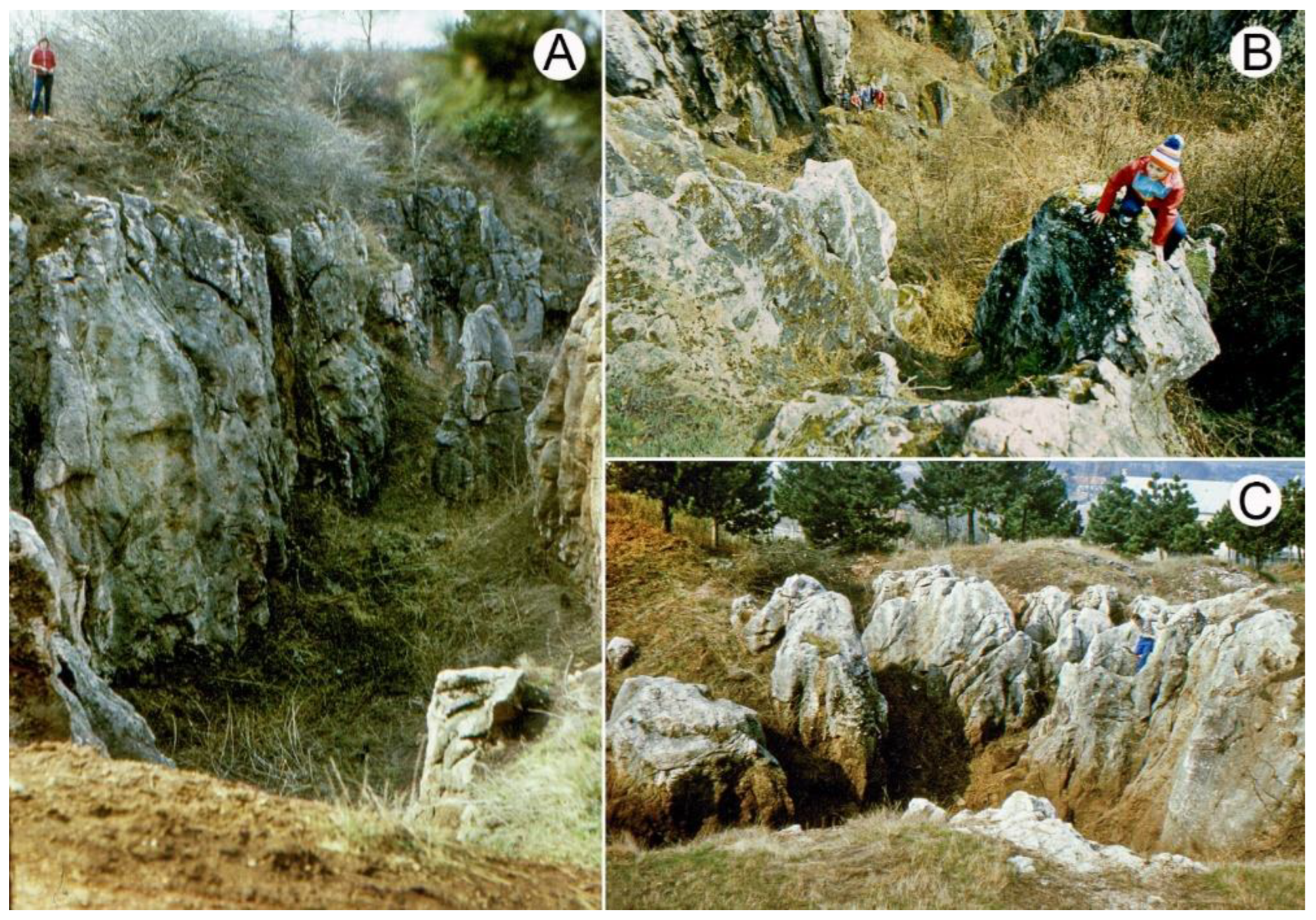
[7]. The manganese ore was exploited by hand in the twenties of the 20th century (here, there is a manganese ore mine with an underground mining operation where exploitation still takes place). As a result, a tropical-type doline with steep slopes was exposed with many solution features on its slope, a gentler, rather temperate solution doline, and a terrain with pinnacle karren features (
Figure 1).
Figure 1. Exposed paleokarst features of Csárda-hegy (hill) (own figure). Legend: (A) tropical doline with steep slopes: (B) solution pit of doline slope; (C) temperate doline with gentle slopes and pinnacle karren.
Bauxite is widespread in the mountains and may constitute a lenticular colony (diameter is about 20 m, thickness is 30–50 m, the bearing features is shallow doline), a deep-doline colony (diameter is 30–50 m, thickness is 80–100 m, the bearing features are deep doline), a bed-like colony (longitudinal expansion is several hundred meters, the bearing feature is polje or uvala), a structural colony (the bearing feature is tectonic graben), a deep-doline and structural colony (a combination of karst feature and structural feature), and a canyon-like colony when it is several hundred meters long; the karst feature is a blind valley
[4][6][8]. Under tropical climates, bauxite is the weathering residue of the rocks of the non-karstic terrain
[8], which was transported into the karst depressions, and then accumulated in them but may have formed in situ as well
[9], or it may have been transported from below by transgression
[10]. The products of lateritic chemical weathering may originate from the peneplain built up of metamorphic rocks surrounding the mountains from S and SE
[11]. It cannot have formed in situ since it is separated from the uneven bedrock without transition; however, the iron crust is mostly present on the bedrock, which may have formed during and after bauxite accumulation
[8].
The bedrock of karst depressions is Triassic Main Dolomite and Dachstein limestone
[6][10], but the material of the depressions of Triassic Main Dolomite may have been reworked and accumulated in Late Cretaceous depressions
[6]. Hungarian bauxites—the bauxites of the Bakony Region—can be classified as belonging to various development stages. The second stage (the first stage occurs in the Villány Mountains) involves the colonies of the Albian Lower Perepuszta (near the settlement of Zirc) and those of Bakonyoszlop. Their bedrock is Upper Triassic Dachstein limestone, and their cover is Upper Cretaceous clay marl. The third stage is the Upper Cretaceous Senonian stage. This includes the colonies of Halimba, Iharkút, and Csabpuszta (Sümeg). Their bedrock is Upper Triassic Main Dolomite, and their cover is Upper Cretaceous limestone or fluvial sandstone, clay, and clay marl. The age of the fourth stage is at the Cretaceous-Eocene boundary. The colonies of Fenyőfő, Dudar, Bakonyoszlop, Szőc, Halimba, and Nyirád belong to this. Their bedrock is Upper Triassic Dolomite, and their cover is Eocene limestone
[4][8]. However, there are colonies whose cover is Eocene limestone or Middle Oligocene-Lower Miocene gravel and Pleistocene sediment
[6][8]. If the caprocks were thinner, their exploitation took place by open-pit mining (Iharkút, Nyírád, Szőc); if they were thicker, they were exploited by underground mining operations (Iszkaszentgyörgy, Halimba, Fenyőfő,
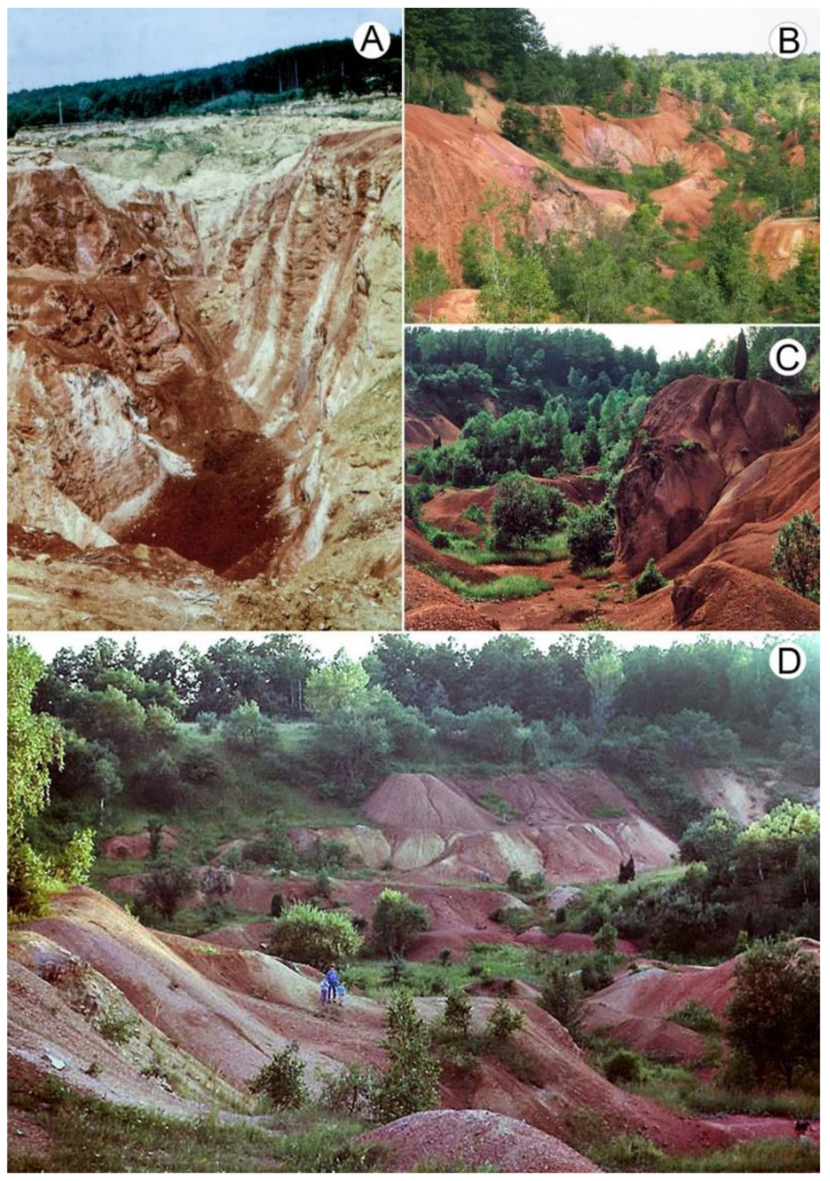
Figure 2). Karst depressions, or the terrain dissected by depressions, became exhumed during open-pit mining (
Figure 5).
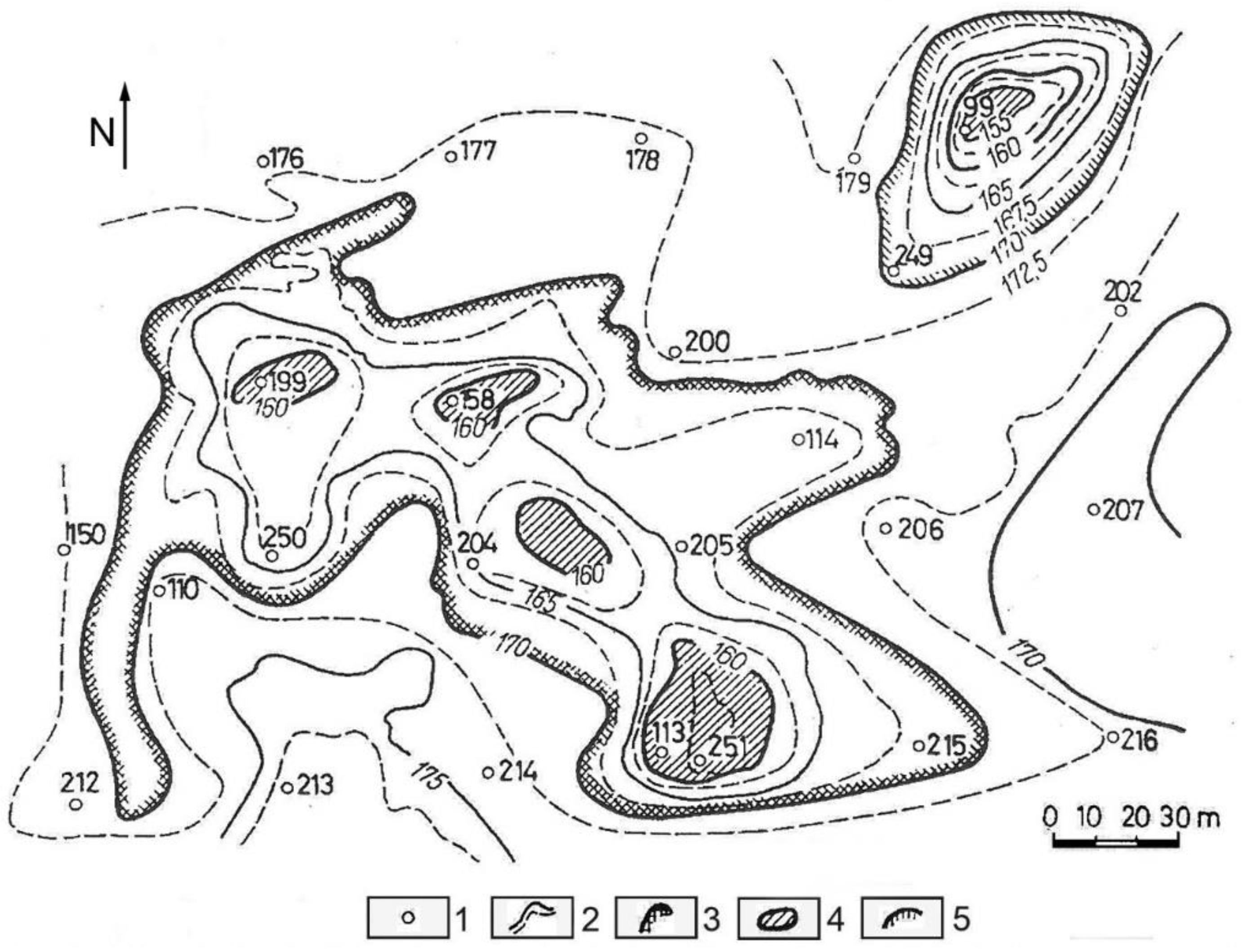
Figure 2. Bedrock map of the Upper Triassic Main Dolomite of the area of Halimba
[12]. Legend: 1. drilling and its number, 2. contour line, 3. uvala, 4. the lowest point of doline, 5. doline.
Figure 3. Surface depressions exhumed during bauxite mining that developed Upper Triassic Main Dolomite: (A) Iharkút, (B–D) Lake Darvas (own figure).
The separation of the manganese ore of Úrkút from mining waste was carried out in the manganese washing plant. The so-formed manganese mud led into one of the depressions of Kab Mountain. The sludge appeared in the spring of the valley located 1.5 km away from this site about three weeks later
[13]. The sludge was led into the doline at a rate of 1 m
3/min, which had an annual quantity of 0.5 million km
3 [13], although the duration of supply is unknown.
Dolomite rubble beds are mined on dolomite at several places between the settlement of Márkó and Várpalota in the mountains. The thickness of the rubble ranges from some meters to several ten meters. According to
[12], its thickness may also exceed 50 m at Nyirád. The reason for rubble formation is that the calcareous material sticking to dolomite crystals is dissolved, and the dolomite falls into parts
[14]. At sites of rubble exploitation, the wavy surface of lower karstic bedrock dolomite is exposed. Inside strip pits, where the rock underwent rubble formation to a lesser degree, the rock was left, and thus, the strip pits are dissected by mounds.
Several caves have been exposed during limestone mining. The longest is the recently discovered several km-long Hárskút Cave, which opens in the quarry of the Kőrisgyörgy Hill. The opened-up caves do not exist for a long time; they become shorter and then decay (e.g., in the quarry of Sümeg).
There was mining activity on the sandstone fields of the Kál Basin. The Pannonian sand became cemented with the amorphous silica that had precipitated from the hot water of post-volcanic activity
[15] on which a rich karren landscape developed
[16]. In the area of the Szentbékálla block field, the material of blocks was partly exploited (during this, several karren features may have been destroyed) for millstone, while that of Kővágóőrs block field was used to build houses. Similarly, quarrying damaged the (calcareous, quartzic) thermal cones of the Tihany Peninsula. Their rocks were used for construction work. Larger and smaller quarries were created on their sides, but at others, almost half of the cone material was exploited, and thus, the cavity of the inner side of the cone was exposed
[17].
2. Indirect Effect on the Karst
An indirect effect develops when the anthropogenic activity does not affect the karst feature, but the alternation of the hydrology of the karst system. The consequences of the changes in hydrological conditions are regional, diverse, and occur fast. The uniform karst water system of the mountains is the main karst water, which primarily developed in the Triassic Main Dolomite. According to drilling and spring data, its former surface was at an elevation of 117.5–154.2 m at the margin of the mountains; it was of an increasingly larger altitude towards the center of the mountains. With the help of the data, a karst water level map was made, which was updated annually. Karst water observation wells were created in order to monitor water level changes; the number of these wells reached 200 within some decades. According to the spring data, the karst water level reached an elevation of 240 m in the inner part of the mountains
[18], while it was at an elevation of 280 m between the settlements of Szentgál and Nagyvázsony based on the data of the constructed map of the karst water level
[19]. In the latter area, the karst water swelled back because of the impermeable rocks of Southern Bakony. In the interest of the safe exploitation of mineral resources (without karst water flood), an artificial lowering of the karst water level was started in the environs of the mines with pumping. Its intensity reached a value of 460 m
3/min. The water level sank below the mines and reached 100 m at some sites
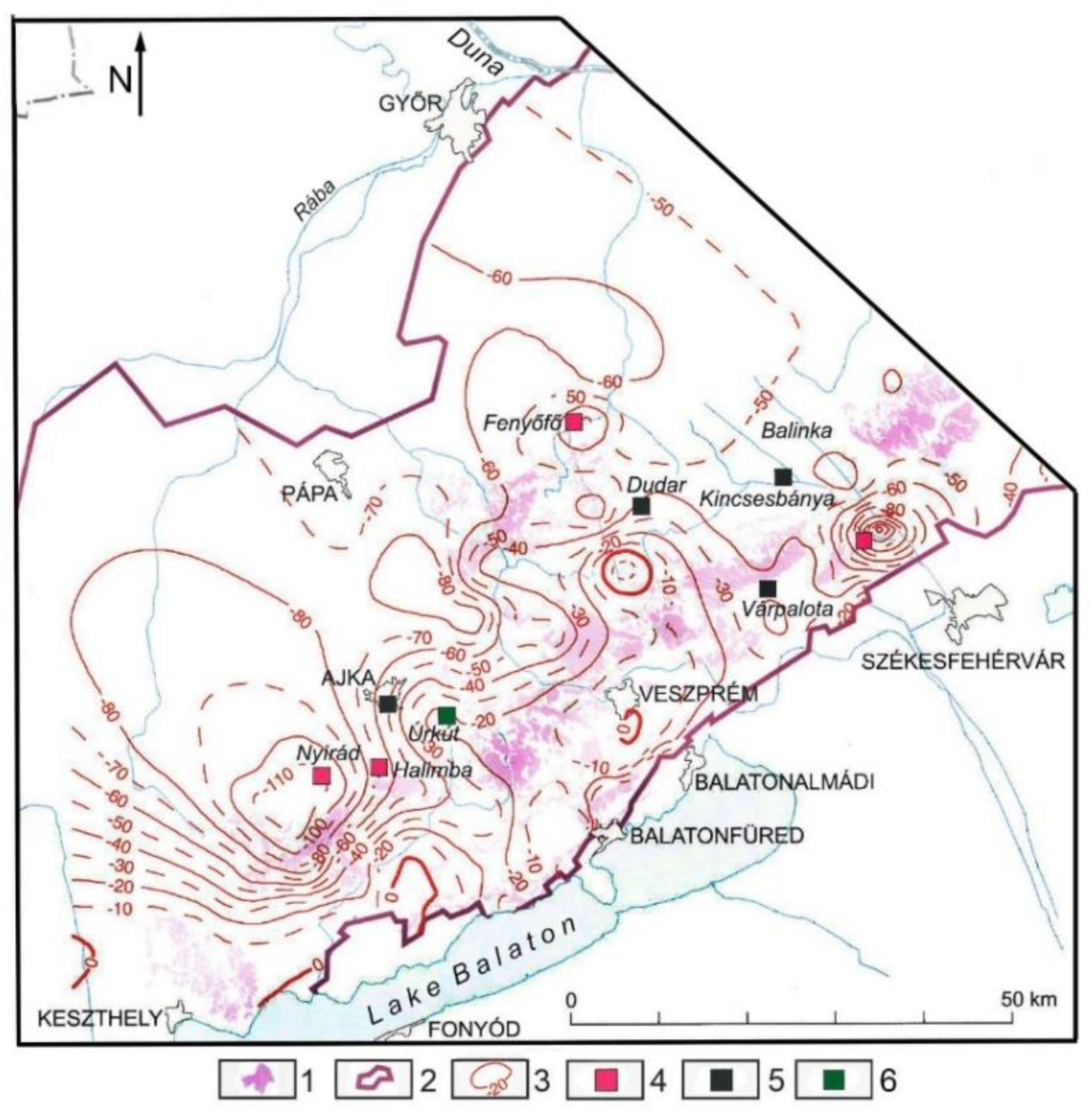
[19]. Depressions developed on its surface. Not only the depth, but also the expansion of depressions increased, and adjacent depressions coalesced. Maximum values of water level subsidence are shown in
Figure 4.
Figure 4. Artificial water level lowering in the Bakony Region
[19]. Legend: 1. infiltration areas, 2. limit of karst water storage, 3. artificial karst water level lowering (m), 4. bauxite mine, 5. coal mine, 6. manganese mine.
This entry is adapted from the peer-reviewed paper 10.3390/mining2040042