There are at least 108 mountains on Earth with elevations of 7,200 metres (23,622 ft) or greater above sea level. The vast majority of these mountains are located on the edge of the Indian and Eurasian plate- namely, in China , Pakistan , Nepal and India .
- nepal
- mountains
- india
1. Considerations

The dividing line between a mountain with multiple peaks and separate mountains is not always clear (see also Highest unclimbed mountain). A popular and intuitive way to distinguish mountains from subsidiary peaks is by their height above the highest saddle connecting it to a higher summit, a measure called topographic prominence or re-ascent (the higher summit is called the "parent peak"). A common definition of a mountain is a summit with 300 m (980 ft) prominence. Alternatively, a relative prominence (prominence/height) is used (usually 7–8%) to reflect that in higher mountain ranges everything is on a larger scale. The table below lists the highest 100 summits with at least 500 m (1,640 ft) prominence, approximating a 7% relative prominence. A drawback of a prominence-based list is that it may exclude well-known or spectacular mountains that are connected via a high ridge to a taller summit, such as Eiger, Nuptse or Annapurna IV. A few such peaks and mountains with nearly sufficient prominence are included in this list, and given a rank of "S".
It is very unlikely that all given heights are correct to the nearest metre; indeed, the sea level is often problematic to define when a mountain is remote from the sea. Different sources often differ by many metres, and the heights given below may well differ from those elsewhere in this encyclopedia. As an extreme example, Ulugh Muztagh on the north Tibetan Plateau is often listed as 7,723 m (25,338 ft) to 7,754 m (25,440 ft), but appears to be only 6,973 m (22,877 ft) to 6,987 m (22,923 ft). Some mountains differ by > 100 m (330 ft) on different maps, while even very thorough current measurements of Mount Everest range from 8,840 m (29,003 ft) to 8,850 m (29,035 ft). These discrepancies serve to emphasize the uncertainties in the listed heights.
Though some parts of the world, especially the most mountainous parts, have never been thoroughly mapped, it is unlikely that any mountains this high have been overlooked, because synthetic aperture radar can and has been used to measure elevations of most otherwise inaccessible places. Still, heights or prominences may be revised, so that the order of the list may change and even "new" mountains could enter the list over time. To be safe, the list has been extended to include all 7,200 m (23,622 ft) peaks.
The highest mountains above sea level are generally not the highest above the surrounding terrain. There is no precise definition of surrounding base, but Denali, Mount Kilimanjaro and Nanga Parbat are possible candidates for the tallest mountain on land by this measure. The bases of mountain islands are below sea level, and given this consideration Mauna Kea (4,207 m (13,802 ft) above sea level) is the world's tallest mountain and volcano, rising about 10,203 m (33,474 ft) from the Pacific Ocean floor. Mount Lamlam on Guam is periodically claimed to be among the world's highest mountains because it is adjacent to the Mariana Trench; the most extreme claim is that, measured from Challenger Deep 313 kilometres (194 mi) away, Mount Lamlam is 37,820 feet (11,530 m) tall.[1][2] Ojos del Salado has the greatest rise on Earth: 13,420 m (44,029 ft) vertically to the summit from the bottom of the Atacama Trench, which is about 560 km (350 mi) away, although most of this rise is not part of the mountain.
The highest mountains are also not generally the most voluminous. Mauna Loa (4,169 m or 13,678 ft) is the largest mountain on Earth in terms of base area (about 2,000 sq mi or 5,200 km2) and volume (about 10,000 cu mi or 42,000 km3), although, due to the intergrade of lava from Kilauea, Hualalai and Mauna Kea, the volume can only be estimated based on surface area and height of the edifice. Mount Kilimanjaro is the largest non-shield volcano in terms of both base area (245 sq mi or 635 km2) and volume (1,150 cu mi or 4,793 km3). Mount Logan is the largest non-volcanic mountain in base area (120 sq mi or 311 km2).
The highest mountains above sea level are also not those with peaks farthest from the centre of the Earth, because the figure of the Earth is not spherical. Sea level closer to the equator is several kilometres farther from the centre of the Earth. The summit of Chimborazo, Ecuador's tallest mountain, is usually considered to be the farthest point from the Earth's centre, although the southern summit of Peru's tallest mountain, Huascarán, is another contender.[3] Both have elevations above sea level more than 2 km less than that of Everest.
2. Geographical Distribution
Almost all mountains in the list are located in the Himalaya and Karakoram ranges to the south and west of the Tibetan plateau. All peaks 7,000 m (23,000 ft) or higher are located in East, Central or South Asia in a rectangle edged by Noshaq (7,492 m or 24,580 ft) on the Afghanistan–Pakistan border in the west, Jengish Chokusu (Tuōmù'ěr Fēng, 7,439 m or 24,406 ft) on the Kyrgyzstan–Xinjiang border to the north, Gongga Shan (Minya Konka, 7,556 m or 24,790 ft) in Sichuan to the east, and Kabru (7,412 m or 24,318 ft) on the Sikkim–Nepal border to the south.
(As of December 2018), the highest peaks on four of the mountains — Gangkhar Puensum, Labuche Kang III, Karjiang, and Tongshanjiabu, all located in Bhutan or China — have not been ascended. The most recent peak to have its first ever ascent is Saser Kangri II East, in India , on 24 August 2011.
The highest mountain outside of Asia is Aconcagua (6,961 m or 22,838 ft), the 189th highest in the world.[4]
3. List of World's Highest Peaks
| Rank[5] | Mountain name(s) | Height[6] | Prominence[7] | Range | Coordinates[8] | Parent mountain [9] |
Ascents before 2004[10] | Country (disputed claims in italics) | ||||
|---|---|---|---|---|---|---|---|---|---|---|---|---|
| first | successful | |||||||||||
| m | ft | m | ft | yes | no | |||||||
| 1 |
|
8,848.86 | 29,031.7[11] | 8,848 | 29,029 | Mahalangur Himalaya | — | 1953 | 145 | 121 |
|
|
| 2 | K2 | 8,611 | 28,251 | 4,020 | 13,190 | Baltoro Karakoram | 35°52′53″N 76°30′48″E / 35.88139°N 76.51333°E / 35.88139; 76.51333 (2. K2 / Qogir / Godwin Austen (8611 m)) | Mount Everest | 1954 | 45 | 44 |
|
| 3 | Kangchenjunga | 8,586 | 28,169 | 3,922 | 12,867 | Kangchenjunga Himalaya | 27°42′12″N 88°08′51″E / 27.70333°N 88.1475°E / 27.70333; 88.1475 (3. Kangchenjunga (8586 m)) * | Mount Everest | 1955 | 38 | 24 |
|
| 4 | Lhotse | 8,516 | 27,940 | 610 | 2,000 | Mahalangur Himalaya | 27°57′42″N 86°55′59″E / 27.96167°N 86.93306°E / 27.96167; 86.93306 (4. Lhotse (8516 m)) | Mount Everest | 1956 | 26 | 26 |
|
| 5 | Makalu | 8,485 | 27,838 | 2,378 | 7,802 | Mahalangur Himalaya | 27°53′23″N 87°05′20″E / 27.88972°N 87.08889°E / 27.88972; 87.08889 (5. Makalu (8485 m)) | Mount Everest | 1955 | 45 | — |
|
| 6 | Cho Oyu | 8,188 | 26,864[14] | 2,340 | 7,680 | Mahalangur Himalaya | 28°05′39″N 86°39′39″E / 28.09417°N 86.66083°E / 28.09417; 86.66083 (6. Cho Oyu (8188 m)) | Mount Everest | 1954 | 79 | 28 |
|
| 7 | Dhaulagiri I | 8,167 | 26,795 | 3,357 | 11,014 | Dhaulagiri Himalaya | 28°41′48″N 83°29′35″E / 28.69667°N 83.49306°E / 28.69667; 83.49306 (7. Dhaulagiri I (8167 m)) | K2 | 1960 | 51 | 39 | Nepal |
| 8 | Manaslu | 8,163 | 26,781 | 3,092 | 10,144 | Manaslu Himalaya | 28°33′00″N 84°33′35″E / 28.55°N 84.55972°E / 28.55; 84.55972 (8. Manaslu (8163 m)) | Cho Oyu | 1956 | 49 | 45 | Nepal |
| 9 | Nanga Parbat | 8,126 | 26,660 | 4,608 | 15,118 | Nanga Parbat Himalaya | 35°14′14″N 74°35′21″E / 35.23722°N 74.58917°E / 35.23722; 74.58917 (9. Nanga Parbat (8126 m)) | Dhaulagiri | 1953 | 52 | 67 | Pakistan [12][15] |
| 10 | Annapurna I | 8,091 | 26,545 | 2,984 | 9,790 | Annapurna Himalaya | 28°35′44″N 83°49′13″E / 28.59556°N 83.82028°E / 28.59556; 83.82028 (10. Annapurna I (8091 m)) | Cho Oyu | 1950 | 97 | 88 | Nepal |
| 11 |
|
8,080 | 26,510 | 2,155 | 7,070 | Baltoro Karakoram | 35°43′28″N 76°41′47″E / 35.72444°N 76.69639°E / 35.72444; 76.69639 (11. Gasherbrum I / Hidden Peak / K5 (8080 m)) | K2 | 1958 | 31 | 16 | |
| 12 | Broad Peak | 8,051 | 26,414 | 1,701 | 5,581 | Baltoro Karakoram | 35°48′38″N 76°34′06″E / 35.81056°N 76.56833°E / 35.81056; 76.56833 (12. Broad Peak / K3 (8051 m)) | Gasherbrum I | 1957 | 39 | 19 | |
| 13 |
|
8,035 | 26,362 | 1,524 | 5,000 | Baltoro Karakoram | 35°45′28″N 76°39′12″E / 35.75778°N 76.65333°E / 35.75778; 76.65333 (13. Gasherbrum II / K4 (8035 m)) | Gasherbrum I | 1956 | 54 | 12 | |
| 14 |
|
8,027 | 26,335 | 2,897 | 9,505 | Jugal Himalaya | 28°21′12″N 85°46′43″E / 28.35333°N 85.77861°E / 28.35333; 85.77861 (14. Shishapangma (8027 m)) | Cho Oyu | 1964 | 43 | 19 | China |
| 15 | Gyachung Kang | 7,952 | 26,089 | 672 | 2,205 | Mahalangur Himalaya | 28°05′53″N 86°44′42″E / 28.09806°N 86.745°E / 28.09806; 86.745 (15. Gyachung Kang (7952 m)) | Cho Oyu | 1964 | 5 | 3 |
|
| S |
|
7,946 | 26,070 | 355 | 1,165 | Baltoro Karakoram | 35°45′33″N 76°38′30″E / 35.75917°N 76.64167°E / 35.75917; 76.64167 (Gasherbrum III (7946 m)) | Gasherbrum II | 1975 | 2 | 2 | |
| 16 | Annapurna II | 7,937 | 26,040 | 2,437 | 7,995 | Annapurna Himalaya | 28°32′05″N 84°07′19″E / 28.53472°N 84.12194°E / 28.53472; 84.12194 (16. Annapurna II (7937 m)) | Annapurna I | 1960 | 6 | 19 | Nepal |
| 17 |
|
7,932 | 26,024 | 712 | 2,336 | Baltoro Karakoram | 35°45′38″N 76°36′58″E / 35.76056°N 76.61611°E / 35.76056; 76.61611 (17. Gasherbrum IV (7932 m)) | Gasherbrum III | 1958 | 4 | 11 | Pakistan [12] |
| 18 | Himalchuli | 7,893 | 25,896 | 1,633 | 5,358 | Manaslu Himalaya | 28°26′12″N 84°38′23″E / 28.43667°N 84.63972°E / 28.43667; 84.63972 (18. Himalchuli (7893 m)) * | Manaslu | 1960 | 6 | 12 | Nepal |
| 19 | Distaghil Sar | 7,884 | 25,866 | 2,525 | 8,284 | Hispar Karakoram | 36°19′33″N 75°11′16″E / 36.32583°N 75.18778°E / 36.32583; 75.18778 (19. Distaghil Sar (7884 m)) | K2 | 1960 | 3 | 5 | Pakistan [12] |
| 20 | Ngadi Chuli | 7,871 | 25,823 | 1,011 | 3,317 | Manaslu Himalaya | 28°30′12″N 84°34′00″E / 28.50333°N 84.5666667°E / 28.50333; 84.5666667 (20. Ngadi Chuli (7871 m)) | Manaslu | 1979 | 1 | 6 | Nepal |
| S | Nuptse | 7,864 | 25,801 | 305 | 1,001 | Mahalangur Himalaya | 27°58′03″N 86°53′13″E / 27.9675°N 86.88694°E / 27.9675; 86.88694 (Nuptse (7864 m)) | Lhotse | 1961 | 5 | 12 | Nepal |
| 21 | Khunyang Chhish | 7,823 | 25,666 | 1,765 | 5,791 | Hispar Karakoram | 36°12′19″N 75°12′28″E / 36.20528°N 75.20778°E / 36.20528; 75.20778 (21. Khunyang Chhish (7823 m)) * | Distaghil Sar | 1971 | 2 | 6 | Pakistan [12] |
| 22 |
|
7,821 | 25,659 | 2,457 | 8,061 | Masherbrum Karakoram | 35°38′28″N 76°18′21″E / 35.64111°N 76.30583°E / 35.64111; 76.30583 (22. Masherbrum / K1 (7821 m)) | Gasherbrum I | 1960 | 4 | 9 | Pakistan [12] |
| 23 | Nanda Devi | 7,816 | 25,643 | 3,139 | 10,299 | Garhwal Himalaya | 30°22′33″N 79°58′15″E / 30.37583°N 79.97083°E / 30.37583; 79.97083 (23. Nanda Devi (7816 m)) | Dhaulagiri | 1936 | 14 | 12 | India |
| 24 | Chomo Lonzo | 7,804 | 25,604 | 590 | 1,940 | Mahalangur Himalaya | 27°55′50″N 87°06′28″E / 27.93056°N 87.10778°E / 27.93056; 87.10778 (24. Chomo Lonzo (7804 m)) | Makalu | 1954 | 3 | 1 | China |
| 25 | Batura Sar | 7,795 | 25,574 | 3,118 | 10,230 | Batura Karakoram | 36°30′37″N 74°31′21″E / 36.51028°N 74.5225°E / 36.51028; 74.5225 (25. Batura Sar (7795 m)) | Distaghil Sar | 1976 | 4 | 6 | Pakistan [12] |
| 26 | Rakaposhi | 7,788 | 25,551 | 2,818 | 9,245 | Rakaposhi-Haramosh Karakoram | 36°08′33″N 74°29′22″E / 36.1425°N 74.48944°E / 36.1425; 74.48944 (26. Rakaposhi (7788 m)) | Khunyang Chhish | 1958 | 8 | 13 | Pakistan [12] |
| 27 | Namcha Barwa | 7,782 | 25,531 | 4,106 | 13,471 | Assam Himalaya | 29°37′52″N 95°03′19″E / 29.63111°N 95.05528°E / 29.63111; 95.05528 (27. Namcha Barwa (7782 m)) | Kangchenjunga | 1992 | 1 | 2 | China |
| 28 | Kanjut Sar | 7,760 | 25,460 | 1,660 | 5,450 | Hispar Karakoram | 36°12′20″N 75°25′01″E / 36.20556°N 75.41694°E / 36.20556; 75.41694 (28. Kanjut Sar (7760 m)) | Khunyang Chhish | 1959 | 2 | 1 | Pakistan [12] |
| 29 | Kamet | 7,756 | 25,446 | 2,825 | 9,268 | Garhwal Himalaya | 30°55′12″N 79°35′30″E / 30.92°N 79.59167°E / 30.92; 79.59167 (29. Kamet (7756 m)) * | Nanda Devi | 1931 | 23 | 14 | India |
| 30 | Dhaulagiri II | 7,751 | 25,430 | 2,397 | 7,864 | Dhaulagiri Himalaya | 28°45′46″N 83°23′18″E / 28.76278°N 83.38833°E / 28.76278; 83.38833 (30. Dhaulagiri II (7751 m)) | Dhaulagiri | 1971 | 4 | 11 | Nepal |
| 31 |
|
7,742 | 25,400 | 2,160 | 7,090 | Saltoro Karakoram | 35°23′57″N 76°50′53″E / 35.39917°N 76.84806°E / 35.39917; 76.84806 (31. Saltoro Kangri / K10 (7742 m)) * | Gasherbrum I | 1962 | 2 | 1 |
|
| 32 |
|
7,711 | 25,299 | 1,036 | 3,399 | Kangchenjunga Himalaya | 27°40′56″N 88°02′40″E / 27.68222°N 88.04444°E / 27.68222; 88.04444 (32. Jannu (7711 m)) * | Kangchenjunga | 1962 | 17 | 12 | Nepal |
| 33 | Tirich Mir | 7,708 | 25,289 | 3,910 | 12,830 | Hindu Kush | 36°15′19″N 71°50′30″E / 36.25528°N 71.84167°E / 36.25528; 71.84167 (33. Tirich Mir (7708 m)) * | Batura Sar | 1950 | 20 | 11 | Pakistan |
| S | Molamenqing | 7,703 | 25,272 | 433 | 1,421 | Langtang Himalaya | 28°21′18″N 85°48′35″E / 28.355°N 85.80972°E / 28.355; 85.80972 (Molamenqing (7703 m)) | Shishapangma | 1981 | 1 | 0 | China |
| 34 | Gurla Mandhata | 7,694 | 25,243 | 2,788 | 9,147 | Nalakankar Himalaya | 30°26′19″N 81°17′48″E / 30.43861°N 81.29667°E / 30.43861; 81.29667 (34. Gurla Mandhata (7694 m)) | Dhaulagiri | 1985 | 6 | 4 | China |
| 35 |
|
7,672 | 25,171 | 2,304 | 7,559 | Saser Karakoram | 34°52′00″N 77°45′09″E / 34.8666667°N 77.7525°E / 34.8666667; 77.7525 (35. Saser Kangri I / K22 (7672 m)) | Gasherbrum I | 1973 | 6 | 4 | India [18] |
| 36 | Chogolisa | 7,665 | 25,148 | 1,624 | 5,328 | Masherbrum Karakoram | 35°36′47″N 76°34′29″E / 35.61306°N 76.57472°E / 35.61306; 76.57472 (36. Chogolisa (7665 m)) | Gasherbrum I | 1975 | 4 | 2 | Pakistan [12] |
| S | Dhaulagiri IV | 7,661 | 25,135 | 469 | 1,539 | Dhaulagiri Himalaya | 28°44′09″N 83°18′55″E / 28.73583°N 83.31528°E / 28.73583; 83.31528 (Dhaulagiri IV (7661 m)) | Dhaulagiri II | 1975 | 2 | 10 | Nepal |
| 37 | Kongur Tagh | 7,649 | 25,095 | 3,585 | 11,762 | Kongur Shan (Eastern Pamirs) | 38°35′36″N 75°18′48″E / 38.59333°N 75.31333°E / 38.59333; 75.31333 (37. Kongur Tagh (7649 m)) | Distaghil Sar | 1981 | 2 | 4 | China |
| S | Dhaulagiri V | 7,618 | 24,993 | 340 | 1,120 | Dhaulagiri Himalaya | 28°44′02″N 83°21′41″E / 28.73389°N 83.36139°E / 28.73389; 83.36139 (Dhaulagiri V (7618 m)) * | Dhaulagiri IV | 1975 | 2 | 3 | Nepal |
| 38 | Shispare | 7,611 | 24,970 | 1,240 | 4,070 | Batura Karakoram | 36°26′26″N 74°40′51″E / 36.44056°N 74.68083°E / 36.44056; 74.68083 (38. Shispare (7611 m)) | Batura Sar | 1974 | 3 | 1 | Pakistan [12] |
| 39 | Trivor | 7,577 | 24,859 | 997 | 3,271 | Hispar Karakoram | 36°17′15″N 75°05′06″E / 36.2875°N 75.085°E / 36.2875; 75.085 (39. Trivor (7577 m)) * | Distaghil Sar | 1960 | 2 | 5 | Pakistan [12] |
| 40 | Gangkhar Puensum | 7,570 | 24,840 | 2,995 | 9,826 | Kula Kangri Himalaya | 28°02′50″N 90°27′19″E / 28.04722°N 90.45528°E / 28.04722; 90.45528 (40. Gangkhar Puensum (7570 m)) * | Kangchenjunga | unclimbed | 0 | 3 |
|
| 41 |
|
7,556 | 24,790 | 3,642 | 11,949 | Daxue Mountains (Hengduan Shan) | 29°35′43″N 101°52′47″E / 29.59528°N 101.87972°E / 29.59528; 101.87972 (41. Gongga Shan / Minya Konka (7556 m)) | Mount Everest | 1932 | 6 | 7 | China |
| 42 | Annapurna III | 7,555 | 24,787 | 703 | 2,306 | Annapurna Himalaya | 28°35′06″N 83°59′24″E / 28.585°N 83.99°E / 28.585; 83.99 (42. Annapurna III (7555 m)) | Annapurna I | 1961 | 10 | 17 | Nepal |
| 43 | Skyang Kangri | 7,545 | 24,754 | 1,085 | 3,560 | Baltoro Karakoram | 35°55′35″N 76°34′03″E / 35.92639°N 76.5675°E / 35.92639; 76.5675 (43. Skyang Kangri (7545 m)) | K2 | 1976 | 1 | 2 | |
| 44 | Changtse | 7,543 | 24,747[19] | 514 | 1,686 | Mahalangur Himalaya | 28°01′29″N 86°54′51″E / 28.02472°N 86.91417°E / 28.02472; 86.91417 (44. Changtse (7543 m)) | Mount Everest | 1982 | 9 | 9 | China |
| 45 | Kula Kangri | 7,538 | 24,731 | 1,654 | 5,427 | Kula Kangri Himalaya | 28°13′37″N 90°36′59″E / 28.22694°N 90.61639°E / 28.22694; 90.61639 (45. Kula Kangri (7538 m)) | Gangkhar Puensum | 1986 | 3 | 2 |
|
| 46 | Kongur Tiube | 7,530 | 24,700 | 840 | 2,760 | Kongur Shan (Eastern Pamirs) | 38°36′57″N 75°11′45″E / 38.61583°N 75.19583°E / 38.61583; 75.19583 (46. Kongur Tiube (7530 m)) | Kongur Tagh | 1956 | 2 | 3 | China |
| S | Annapurna IV | 7,525 | 24,688 | 255 | 837 | Annapurna Himalaya | 28°32′15″N 84°4′58″E / 28.5375°N 84.08278°E / 28.5375; 84.08278 (Annapurna IV (7,525 m)) | Annapurna | 1955 | 43 | 18 | Nepal |
| 47 | Mamostong Kangri | 7,516 | 24,659 | 1,803 | 5,915 | Rimo Karakoram | 35°08′31″N 77°34′39″E / 35.14194°N 77.5775°E / 35.14194; 77.5775 (47. Mamostong Kangri (7516 m)) | Gasherbrum I | 1984 | 5 | 0 | India [18] |
| 48 | Saser Kangri II E | 7,513 | 24,649 | 1,458 | 4,783 | Saser Karakoram | 34°48′17″N 77°48′24″E / 34.80472°N 77.80667°E / 34.80472; 77.80667 (48. Saser Kangri II E (7513 m)) | Saser Kangri I | 2011 | 0 | 0[21] | India '[18] |
| 49 | Muztagh Ata | 7,509 | 24,636 | 2,698 | 8,852 | Muztagata (Eastern Pamirs) | 38°16′33″N 75°06′58″E / 38.27583°N 75.11611°E / 38.27583; 75.11611 (49. Muztagh Ata (7546 m)) | Kongur Tagh | 1956 | many | — | China |
| 50 | Ismoil Somoni Peak | 7,495 | 24,590 | 3,402 | 11,161 | Pamir (Academy of Sciences Range) | 38°56′35″N 72°00′57″E / 38.94306°N 72.01583°E / 38.94306; 72.01583 (50. Ismoil Somoni Peak (7495 m)) | Muztagh Ata | 1933 | — | — | Tajikistan |
| 51 | Saser Kangri III | 7,495 | 24,590 | 835 | 2,740 | Saser Karakoram | 34°50′44″N 77°47′06″E / 34.84556°N 77.785°E / 34.84556; 77.785 (51. Saser Kangri III (7495 m)) | Saser Kangri I | 1986 | 1 | 0 | India '[18] |
| 52 | Noshaq | 7,492 | 24,580 | 2,024 | 6,640 | Hindu Kush | 36°25′56″N 71°49′43″E / 36.43222°N 71.82861°E / 36.43222; 71.82861 (52. Noshaq (7492 m)) | Tirich Mir | 1960 | 33 | 3 |
|
| 53 | Pumari Chhish | 7,492 | 24,580 | 884 | 2,900 | Hispar Karakoram | 36°12′41″N 75°15′01″E / 36.21139°N 75.25028°E / 36.21139; 75.25028 (53. Pumari Chhish (7492 m)) | Khunyang Chhish | 1979 | 1 | 2 | Pakistan [12] |
| 54 | Passu Sar | 7,476 | 24,528 | 647 | 2,123 | Batura Karakoram | 36°29′16″N 74°35′16″E / 36.48778°N 74.58778°E / 36.48778; 74.58778 (54. Passu Sar (7476 m)) | Batura Sar | 1994 | 1 | 0 | Pakistan [12] |
| 55 | Yukshin Gardan Sar | 7,469 | 24,505 | 1,374 | 4,508 | Hispar Karakoram | 36°15′04″N 75°22′29″E / 36.25111°N 75.37472°E / 36.25111; 75.37472 (55. Yukshin Gardan Sar (7469 m)) | Pumari Chhish | 1984 | 4 | 1 | Pakistan [12] |
| 56 | Teram Kangri I | 7,462 | 24,482 | 1,703 | 5,587 | Siachen Karakoram | 35°34′48″N 77°04′42″E / 35.58°N 77.07833°E / 35.58; 77.07833 (56. Teram Kangri I (7462 m)) | Gasherbrum I | 1975 | 2 | 0 |
|
| 57 | Jongsong Peak | 7,462 | 24,482 | 1,298 | 4,259 | Kangchenjunga Himalaya | 27°52′54″N 88°08′09″E / 27.88167°N 88.13583°E / 27.88167; 88.13583 (57. Jongsong Peak (7462 m)) | Kangchenjunga | 1930 | 2 | 3 |
|
| 58 | Malubiting | 7,458 | 24,469 | 2,193 | 7,195 | Rakaposhi-Haramosh Karakoram | 36°00′12″N 74°52′31″E / 36.00333°N 74.87528°E / 36.00333; 74.87528 (58. Malubiting (7458 m)) | Rakaposhi | 1971 | 2 | 6 | Pakistan [12] |
| 59 | Gangapurna | 7,455 | 24,459 | 563 | 1,847 | Annapurna Himalaya | 28°36′18″N 83°57′49″E / 28.605°N 83.96361°E / 28.605; 83.96361 (59. Gangapurna (7455 m)) | Annapurna III | 1965 | 8 | 13 | Nepal |
| 60 |
|
7,439 | 24,406 | 4,148 | 13,609 | Tian Shan | 42°02′05″N 80°07′47″E / 42.03472°N 80.12972°E / 42.03472; 80.12972 (60. Jengish Chokusu / Tömür / Pk Pobeda (7439 m)) | Ismail Samani Peak | 1956 | — | — |
|
| S |
|
7,434 | 24,390 | 229 | 751 | Garhwal Himalaya | 30°22′00″N 79°59′40″E / 30.3666667°N 79.99444°E / 30.3666667; 79.99444 (Sunanda Devi (7434 m)) | Nanda Devi | 1939 | 14 | 12 | India |
| 61 | K12 | 7,428 | 24,370 | 1,978 | 6,490 | Saltoro Karakoram | 35°17′45″N 77°01′20″E / 35.29583°N 77.02222°E / 35.29583; 77.02222 (61. K12 (7428 m)) | Saltoro Kangri | 1974 | 4 | 2 |
|
| 62 |
|
7,422 | 24,350 | 2,352 | 7,717 | Ganesh Himalaya | 28°23′29″N 85°07′38″E / 28.39139°N 85.12722°E / 28.39139; 85.12722 (62. Yangra / Ganesh I (7422 m)) | Shishapangma | 1955 | 1 | 6 |
|
| 63 | Sia Kangri | 7,422 | 24,350 | 642 | 2,106 | Siachen Karakoram | 35°39′48″N 76°45′42″E / 35.66333°N 76.76167°E / 35.66333; 76.76167 (63. Sia Kangri (7422 m)) | Gasherbrum I | 1934 | 6 | 0 |
|
| 64 | Momhil Sar | 7,414 | 24,324 | 907 | 2,976 | Hispar Karakoram | 36°19′04″N 75°02′11″E / 36.31778°N 75.03639°E / 36.31778; 75.03639 (64. Momhil Sar (7414 m)) * | Trivor | 1964 | 2 | 6 | Pakistan [12] |
| 65 | Kabru N | 7,412 | 24,318 | 720 | 2,360 | Kangchenjunga Himalaya | 27°38′02″N 88°07′00″E / 27.63389°N 88.1166667°E / 27.63389; 88.1166667 (65. Kabru N (7412 m)) | Kangchenjunga | 1994 | 1 | 2[22] |
|
| 66 | Skil Brum | 7,410 | 24,310 | 1,152 | 3,780 | Baltoro Karakoram | 35°51′03″N 76°25′43″E / 35.85083°N 76.42861°E / 35.85083; 76.42861 (66. Skil Brum (7410 m)) | K2 | 1957 | 2 | 1 | Pakistan [12] |
| 67 | Haramosh Peak | 7,409 | 24,308 | 2,277 | 7,470 | Rakaposhi-Haramosh Karakoram | 35°50′24″N 74°53′51″E / 35.84°N 74.8975°E / 35.84; 74.8975 (67. Haramosh Peak (7409 m)) | Malubiting | 1958 | 4 | 3 | Pakistan [12] |
| 68 | Istor-o-Nal | 7,403 | 24,288 | 1,043 | 3,422 | Hindu Kush | 36°22′32″N 71°53′54″E / 36.37556°N 71.89833°E / 36.37556; 71.89833 (68. Istor-o-Nal (7403 m)) | Noshaq | 1969 | 4 | 5 | Pakistan |
| 69 | Ghent Kangri | 7,401 | 24,281 | 1,493 | 4,898 | Saltoro Karakoram | 35°31′04″N 76°48′02″E / 35.51778°N 76.80056°E / 35.51778; 76.80056 (69. Ghent Kangri (7401 m)) | Saltoro Kangri | 1961 | 4 | 0 |
|
| 70 | Ultar | 7,388 | 24,239 | 688 | 2,257 | Batura Karakoram | 36°23′27″N 74°43′00″E / 36.39083°N 74.7166667°E / 36.39083; 74.7166667 (70. Ultar (7388 m)) | Shispare | 1996 | 2 | 5 | Pakistan [12] |
| 71 | Rimo I | 7,385 | 24,229 | 1,428 | 4,685 | Rimo Karakoram | 35°21′18″N 77°22′08″E / 35.355°N 77.36889°E / 35.355; 77.36889 (71. Rimo I (7385 m)) | Teram Kangri I | 1988 | 1 | 3 | India [23] |
| 72 | Churen Himal | 7,385 | 24,229 | 650 | 2,130 | Dhaulagiri Himalaya | 28°44′05″N 83°13′03″E / 28.73472°N 83.2175°E / 28.73472; 83.2175 (72. Churen Himal (7385 m)) | Dhaulagiri IV | 1970 | 3 | 0 | Nepal |
| 73 | Teram Kangri III | 7,382 | 24,219 | 520 | 1,710 | Siachen Karakoram | 35°35′59″N 77°02′53″E / 35.59972°N 77.04806°E / 35.59972; 77.04806 (73. Teram Kangri III (7382 m)) | Teram Kangri I | 1979 | 1 | 0 |
|
| 74 | Sherpi Kangri | 7,380 | 24,210 | 1,320 | 4,330 | Saltoro Karakoram | 35°27′58″N 76°46′53″E / 35.46611°N 76.78139°E / 35.46611; 76.78139 (74. Sherpi Kangri (7380 m)) * | Ghent Kangri | 1976 | 1 | 1 |
|
| 75 | Labuche Kang | 7,367 | 24,170 | 1,957 | 6,421 | Labuche Himalaya | 28°18′15″N 86°21′03″E / 28.30417°N 86.35083°E / 28.30417; 86.35083 (75. Labuche Kang (7367 m)) | Cho Oyu | 1987 | 1 | 0 | China |
| 76 | Kirat Chuli | 7,362 | 24,154 | 1,168 | 3,832 | Kangchenjunga Himalaya | 27°47′16″N 88°11′43″E / 27.78778°N 88.19528°E / 27.78778; 88.19528 (76. Kirat Chuli (7362 m)) | Kangchenjunga | 1939 | 1 | 6 |
|
| S | Abi Gamin | 7,355 | 24,131 | 217 | 712 | Garhwal Himalaya | 30°55′57″N 79°36′09″E / 30.9325°N 79.6025°E / 30.9325; 79.6025 (Abi Gamin (7355 m)) | Kamet | 1950 | 17 | 2 |
|
| S |
|
7,350 | 24,110 | 432 | 1,417 | Kangchenjunga Himalaya | 27°44′27″N 88°09′31″E / 27.74083°N 88.15861°E / 27.74083; 88.15861 (Gimmigela / The Twins (7350 m)) | Kangchenjunga | 1994 | 3 | 1 |
|
| S | Nangpai Gosum | 7,350 | 24,110 | 427 | 1,401 | Mahalangur Himalaya | 28°04′24″N 86°36′51″E / 28.07333°N 86.61417°E / 28.07333; 86.61417 (Nangpai Gosum (7350 m)) | Cho Oyu | 1986 | 1[24] |
|
|
| 77 | Saraghrar | 7,349 | 24,111 | 1,979 | 6,493 | Hindu Kush | 36°32′51″N 72°06′54″E / 36.5475°N 72.115°E / 36.5475; 72.115 (77. Saraghrar (7349 m)) | Noshaq | 1959 | 2 | 3 | Pakistan |
| S | Talung | 7,349 | 24,111 | 366 | 1,201 | Kangchenjunga Himalaya | 27°39′18″N 88°07′51″E / 27.655°N 88.13083°E / 27.655; 88.13083 (Talung (7349 m)) * | Kabru | 1964 | 3 | 4[25] |
|
| 78 |
|
7,326 | 24,035 | 2,341 | 7,680 | Jomolhari Himalaya | 27°49′36″N 89°16′04″E / 27.82667°N 89.26778°E / 27.82667; 89.26778 (78. Jomolhari (7326 m)) * | Gangkhar Puensum | 1937 | 4 | 0 |
|
| 79 | Chamlang | 7,321 | 24,019 | 1,241 | 4,072 | Mahalangur Himalaya | 27°46′30″N 86°58′47″E / 27.775°N 86.97972°E / 27.775; 86.97972 (79. Chamlang (7321 m)) | Lhotse | 1961 | 7 | 1 | Nepal |
| 80 | Chongtar | 7,315 | 23,999 | 1,295 | 4,249 | Baltoro Karakoram | 35°54′55″N 76°25′45″E / 35.91528°N 76.42917°E / 35.91528; 76.42917 (80. Chongtar (7315 m)) | Skil Brum | 1994 | 1 | 1 | China [16] |
| 81 | Baltoro Kangri | 7,312 | 23,990 | 1,140 | 3,740 | Masherbrum Karakoram | 35°38′21″N 76°40′24″E / 35.63917°N 76.67333°E / 35.63917; 76.67333 (81. Baltoro Kangri (7312 m)) | Chogolisa | 1963 | 1 | 0 | Pakistan [12] |
| 82 | Siguang Ri | 7,309 | 23,980 | 669 | 2,195 | Mahalangur Himalaya | 28°08′50″N 86°41′06″E / 28.14722°N 86.685°E / 28.14722; 86.685 (82. Siguang Ri (7309 m)) | Cho Oyu | 1989 | 2 | 1 | China |
| 83 |
|
7,295 | 23,934 | 1,919 | 6,296 | Yengisogat Karakoram | 36°06′24″N 76°12′21″E / 36.10667°N 76.20583°E / 36.10667; 76.20583 (83. The Crown / Huang Guan (7295 m)) | Skil Brum (K2) | 1993 | 1 | 5 | China [16] |
| 84 | Gyala Peri | 7,294 | 23,930 | 2,942 | 9,652 | Assam Himalaya | 29°48′52″N 94°58′07″E / 29.81444°N 94.96861°E / 29.81444; 94.96861 (84. Gyala Peri (7294 m)) | Mount Everest | 1986 | 1 | 0 | China |
| 85 | Porong Ri | 7,292 | 23,924 | 512 | 1,680 | Langtang Himalaya | 28°23′22″N 85°43′12″E / 28.38944°N 85.72°E / 28.38944; 85.72 (85. Porong Ri (7292 m)) | Shishapangma | 1982 | 5 | 0 | China |
| 86 |
|
7,285 | 23,901 | 1,891 | 6,204 | Panmah Karakoram | 35°56′51″N 75°45′12″E / 35.9475°N 75.75333°E / 35.9475; 75.75333 (86. Baintha Brakk / The Ogre (7285 m)) * | Kanjut Sar | 1977 | 3 | 13 | Pakistan [12] |
| 87 | Yutmaru Sar | 7,283 | 23,894 | 680 | 2,230 | Hispar Karakoram | 36°13′35″N 75°22′02″E / 36.22639°N 75.36722°E / 36.22639; 75.36722 (87. Yutmaru Sar (7283 m)) | Yukshin Gardan Sar | 1980 | 1 | 1 | Pakistan [12] |
| 88 |
|
7,282 | 23,891 | 1,962 | 6,437 | Masherbrum Karakoram | 35°25′06″N 76°33′06″E / 35.41833°N 76.55167°E / 35.41833; 76.55167 (88. Baltistan Peak / K6 (7282 m)) | Chogolisa | 1970 | 1 | 3 | Pakistan [12] |
| 89 |
|
7,281 | 23,888 | 1,345 | 4,413 | Baiku Himalaya | 28°33′03″N 85°32′44″E / 28.55083°N 85.54556°E / 28.55083; 85.54556 (89. Kangpenqing / Gang Benchhen (7281 m)) | Shishapangma | 1982 | 1 | 1 | China |
| 90 | Muztagh Tower | 7,276 | 23,871 | 1,710 | 5,610 | Baltoro Karakoram | 35°49′40″N 76°21′40″E / 35.82778°N 76.36111°E / 35.82778; 76.36111 (90. Muztagh Tower (7276 m)) | Skil Brum | 1956 | 4 | 2 | |
| 91 | Mana Peak | 7,272 | 23,858 | 732 | 2,402 | Garhwal Himalaya | 30°52′50″N 79°36′55″E / 30.88056°N 79.61528°E / 30.88056; 79.61528 (91. Mana Peak (7272 m)) | Kamet | 1937 | 7 | 3 | India |
| S | Dhaulagiri VI | 7,268 | 23,845 | 488 | 1,601 | Dhaulagiri Himalaya | 28°42′31″N 83°16′27″E / 28.70861°N 83.27417°E / 28.70861; 83.27417 (Dhaulagiri VI (7268 m)) | Dhaulagiri IV | 1970 | 5 | 0 | Nepal |
| 92 | Diran | 7,266 | 23,839 | 1,329 | 4,360 | Rakaposhi-Haramosh Karakoram | 36°07′13″N 74°39′42″E / 36.12028°N 74.66167°E / 36.12028; 74.66167 (92. Diran (7266 m)) | Malubiting | 1968 | 12 | 8 | Pakistan [12] |
| 93 |
|
7,250 | 23,790[26] | 570 | 1,870 | Labuche Himalaya | 28°18′05″N 86°23′02″E / 28.30139°N 86.38389°E / 28.30139; 86.38389 (93. Labuche Kang III / East (7250 m)) | Labuche Himilaya | unclimbed | 0 | 0 | China |
| 94 | Putha Hiunchuli | 7,246 | 23,773 | 1,151 | 3,776 | Dhaulagiri Himalaya | 28°44′52″N 83°08′46″E / 28.74778°N 83.14611°E / 28.74778; 83.14611 (94. Putha Hiunchuli (7246 m)) | Churen Himal | 1954 | 11 | 5 | Nepal |
| 95 | Apsarasas Kangri | 7,245 | 23,770 | 607 | 1,991 | Siachen Karakoram | 35°32′19″N 77°08′55″E / 35.53861°N 77.14861°E / 35.53861; 77.14861 (95. Apsarasas Kangri (7245 m)) | Teram Kangri I | 1976 | 2 | 0 |
|
| 96 | Mukut Parbat | 7,242 | 23,760 | 683 | 2,241 | Garhwal Himalaya | 30°56′57″N 79°34′12″E / 30.94917°N 79.57°E / 30.94917; 79.57 (96. Mukut Parbat (7242 m)) | Kamet | 1951 | 2 | 1 |
|
| 97 | Rimo III | 7,233 | 23,730 | 613 | 2,011 | Rimo Karakoram | 35°22′31″N 77°21′42″E / 35.37528°N 77.36167°E / 35.37528; 77.36167 (97. Rimo III (7233 m)) | Rimo I | 1985 | 1 | 0 | India [23]'[18] |
| 98 | Langtang Lirung | 7,227 | 23,711 | 1,534 | 5,033 | Langtang Himalaya | 28°15′22″N 85°31′01″E / 28.25611°N 85.51694°E / 28.25611; 85.51694 (98. Langtang Lirung (7227 m)) | Shishapangma | 1978 | 14 | 13 | Nepal |
| 99 | Karjiang | 7,221 | 23,691 | 895 | 2,936 | Kula Kangri Himalaya | 28°15′27″N 90°38′49″E / 28.2575°N 90.64694°E / 28.2575; 90.64694 (99. Karjiang (7221 m)) | Kula Kangri | unclimbed | 0 | 2 | China |
| 100 | Annapurna Dakshin (Annapurna South) | 7,219 | 23,684 | 769 | 2,523 | Annapurna Himalaya | 28°31′06″N 83°48′22″E / 28.51833°N 83.80611°E / 28.51833; 83.80611 (100. Annapurna Dakshin (7219 m)) | Annapurna | 1964 | 10 | 16 | Nepal |
| 101 | Khartaphu | 7,213 | 23,665 | 712 | 2,336 | Mahalangur Himalaya | 28°03′49″N 86°58′39″E / 28.06361°N 86.9775°E / 28.06361; 86.9775 (101. Khartaphu (7213 m)) | Mount Everest | 1935 | 1 | 0 | China |
| 102 | Tongshanjiabu[27] | 7,207 | 23,645 | 1,757 | 5,764 | Lunana Himalaya | 28°11′12″N 89°57′27″E / 28.18667°N 89.9575°E / 28.18667; 89.9575 (102. Tongshanjiabu (7207 m)) | Gangkhar Puensum | unclimbed | 0 | 0 |
|
| 103 | Malangutti Sar | 7,207 | 23,645 | 507 | 1,663 | Hispar Karakoram | 36°21′47″N 75°08′57″E / 36.36306°N 75.14917°E / 36.36306; 75.14917 (103. Malangutti Sar (7207 m)) | Distaghil Sar | 1985 | 1 | 0 | Pakistan [12] |
| 104 |
|
7,206 | 23,642 | 2,160 | 7,090 | Nagarze Himalaya | 28°56′48″N 90°10′42″E / 28.94667°N 90.17833°E / 28.94667; 90.17833 (104. Noijin Kangsang / Norin Kang (7206 m)) | Gangkhar Puensum | 1986 | 4 | 1 | China |
| 105 | Langtang Ri | 7,205 | 23,638 | 665 | 2,182 | Langtang Himalaya | 28°22′53″N 85°41′01″E / 28.38139°N 85.68361°E / 28.38139; 85.68361 (105. Langtang Ri (7205 m)) | Shishapangma | 1981 | 4 | 0 |
|
| 106 |
|
7,204 | 23,635 | 1,244 | 4,081 | Lunana Himalaya | 28°09′24″N 90°04′15″E / 28.15667°N 90.07083°E / 28.15667; 90.07083 (106. Kangphu Kang (7204 m)) | Tongshanjiabu | 2002 | 1 | 0[29] |
|
| 107 | Singhi Kangri | 7,202 | 23,629 | 730 | 2,400 | Siachen Karakoram | 35°35′59″N 76°59′01″E / 35.59972°N 76.98361°E / 35.59972; 76.98361 (107. Singhi Kangri (7202 m)) | Teram Kangri III | 1976 | 2 | 0 |
|
| 108 | Lupghar Sar | 7,200 | 23,600 | 730 | 2,400 | Hispar Karakoram | 36°21′01″N 75°02′13″E / 36.35028°N 75.03694°E / 36.35028; 75.03694 (108. Lupghar Sar (7200 m)) * | Momhil Sar | 1979 | 1 | 0 | Pakistan [12] |
4. Data Plots
4.1. By Country
The following graph ranks the countries by number of mountain peaks over 7,200 metres (23,622 ft) above sea level. Note that 38 peaks are on de facto borders and two (Jongsong Peak and Sia Kangri) are on tripoints.
<timeline> Colors=
id:lightgrey value:gray(0.9) id:darkgrey value:gray(0.8) id:sfondo value:rgb(1,1,1) id:barra value:rgb(0.6,0.7,0.8)
ImageSize = width:600 height:305 PlotArea = left:50 bottom:50 top:30 right:30 DateFormat = x.y Period = from:0 till:65 TimeAxis = orientation:vertical AlignBars = justify ScaleMajor = gridcolor:white increment:5 start:0 BackgroundColors = canvas:sfondo
BarData=
bar:China text:China bar:Pakistan text:Pakistan bar:Nepal text:Nepal bar:India text:India bar:Bhutan text:Bhutan bar:Afghanistan text:Afghanistan bar:Kyrgyzstan text:Kyrgyzstan bar:Tajikistan text:Tajikistan
PlotData=
color:Barra width:40 align:center
bar:China from: 0 till:50 bar:Pakistan from: 0 till:42 bar:Nepal from: 0 till:32 bar:India from: 0 till:27 bar:Bhutan from: 0 till:5 bar:Afghanistan from: 0 till:1 bar:Kyrgyzstan from: 0 till:1 bar:Tajikistan from: 0 till:1
PlotData=
bar:China at:51 fontsize:S text: 50 shift:(2,0) bar:Pakistan at:43 fontsize:S text: 42 shift:(2,0) bar:Nepal at:33 fontsize:S text: 32 shift:(2,0) bar:India at:28 fontsize:S text: 27 shift:(2,0) bar:Bhutan at:6 fontsize:S text: 5 shift:(2,0) bar:Afghanistan at:2 fontsize:S text: 1 shift:(2,0) bar:Kyrgyzstan at:2 fontsize:S text: 1 shift:(2,0) bar:Tajikistan at:2 fontsize:S text: 1 shift:(2,0)
TextData=
fontsize:S pos:(20,10) text:Number of mountain peaks over 7,200m above sea level (status quo)
</timeline>
4.2. Stem and Leaf Plot
The following is a stem and leaf plot of the above data. The two digits to the left of the line are the first two digits of the mountain's height (metres), and each digit to the right of the line represents the third digit of the mountain's height. Each number on the right is linked to the corresponding mountain's article. For example, the height of one of the mountains (namely Mount Everest) is 8,848 metres (29,029 ft). Also, it is apparent that there are five mountains above 8,200 metres (26,900 ft).
88 | 4
87 |
86 | 1
85 | 8 1
84 | 8
83 |
82 |
81 | 8 6 6 2
80 | 9 8 5 3 2
79 | 5 4 3 3
78 | 9 8 7 6 2 2 1 0
77 | 9 9 8 8 5 5 4 1 0 0
76 | 9 7 6 6 4 1 1
75 | 7 7 5 5 4 4 4 3 3 1 1
74 | 9 9 9 9 7 6 6 6 5 5 3 3 2 2 2 1 1 1 0 0 0
73 | 8 8 8 8 8 6 6 5 5 5 4 2 1 1 1 0
72 | 9 9 9 8 8 8 8 7 7 6 6 5 4 4 4 3 2 2 1 1 0 0 0 0 0 0 0
5. Gallery
The fourteen eight-thousanders
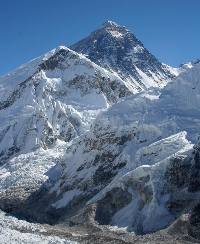
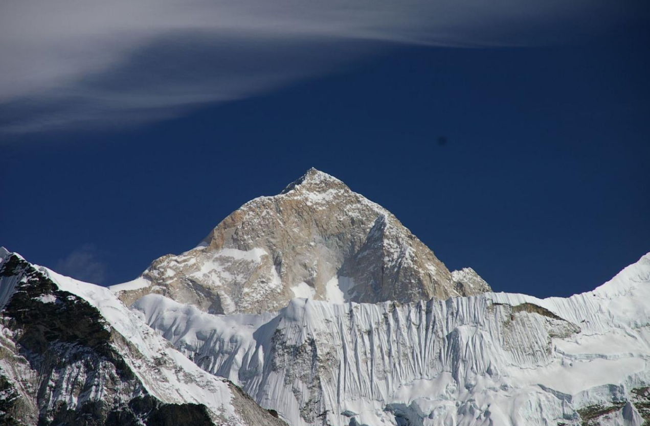
1. The summit of Mount Everest, the highest point on Earth. https://handwiki.org/wiki/index.php?curid=1824841
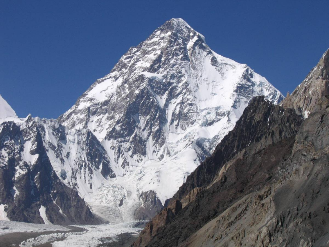
2. K2, the highest summit of the Karakoram. https://handwiki.org/wiki/index.php?curid=1292987
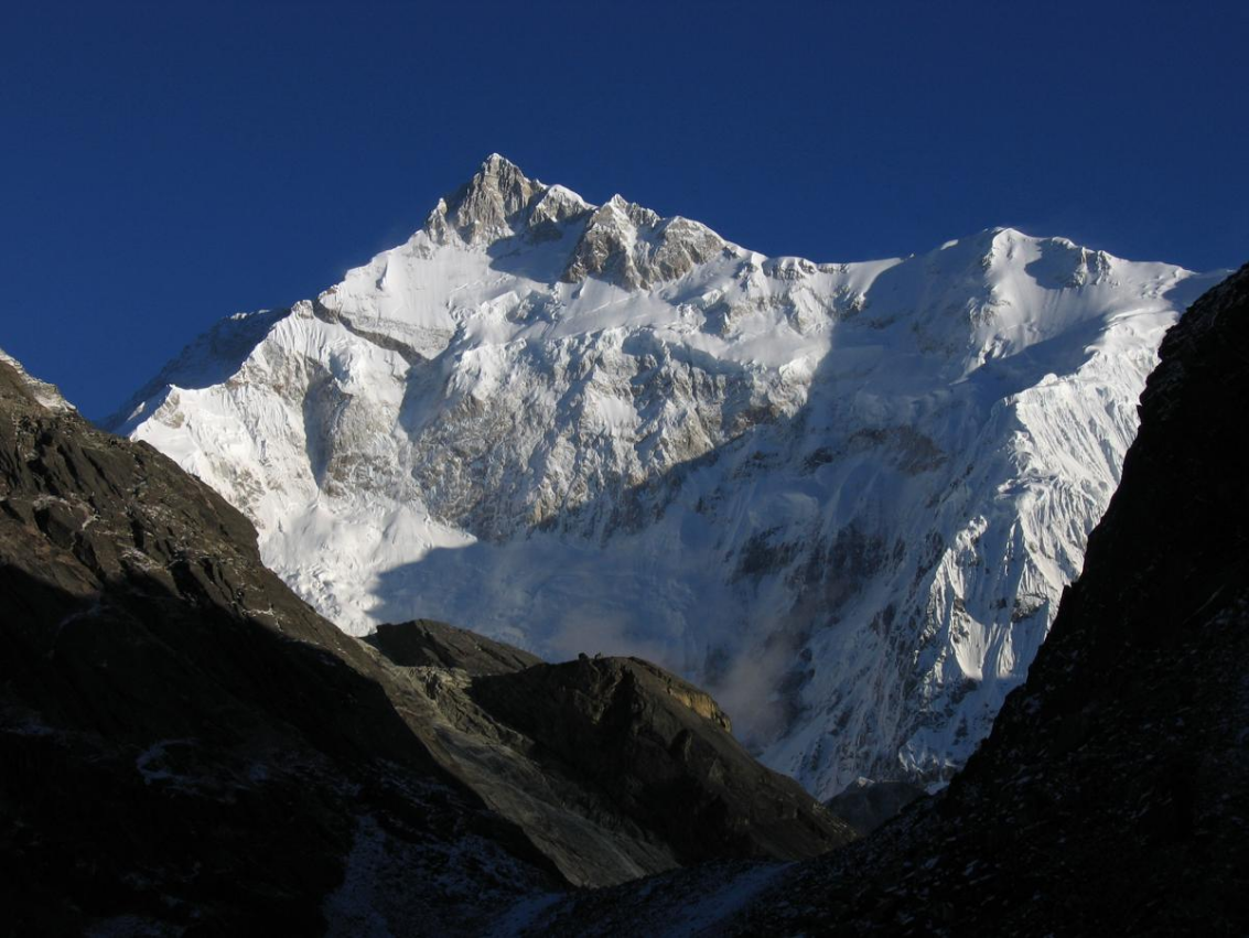
3. Kangchenjunga, the second-highest mountain of the Himalaya. https://handwiki.org/wiki/index.php?curid=1306620
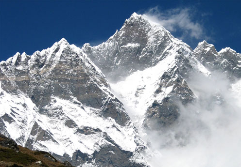
4. Lhotse, the third-highest mountain of the Himalaya. https://handwiki.org/wiki/index.php?curid=1787858
5. Makalu in the Himalaya. https://handwiki.org/wiki/index.php?curid=1329244
6. Cho Oyu in the Himalaya. https://handwiki.org/wiki/index.php?curid=1270387
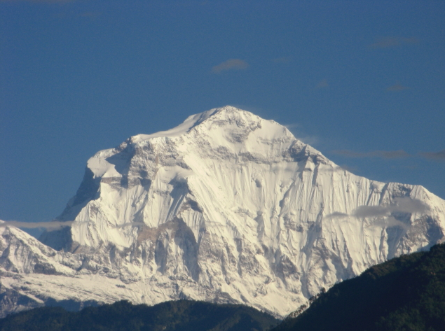
7. Dhaulagiri in the Himalaya. https://handwiki.org/wiki/index.php?curid=1148195
8. Manaslu in the Himalaya. https://handwiki.org/wiki/index.php?curid=1330889

9. Nanga Parbat in the Himalaya https://handwiki.org/wiki/index.php?curid=1193553
10. Annapurna I in the Himalaya. https://handwiki.org/wiki/index.php?curid=1748239
11. Gasherbrum I, the second-highest mountain of the Karakoram. https://handwiki.org/wiki/index.php?curid=1401594

12. Broad Peak, the third-highest mountain of the Karakoram. https://handwiki.org/wiki/index.php?curid=1559856
13. Gasherbrum II in the Karakoram. https://handwiki.org/wiki/index.php?curid=1723012
14. Shishapangma in the Himalaya. https://handwiki.org/wiki/index.php?curid=1220944
The content is sourced from: https://handwiki.org/wiki/Earth:List_of_highest_mountains_on_Earth
References
- McMahon, Mary (January 23, 2021). "How do Scientists Determine the World's Tallest Mountain?". https://www.infobloom.com/how-do-scientists-determine-the-worlds-tallest-mountain.htm.
- Fichtl, Marcus (August 31, 2017). "Guam's Mount Lamlam technically world's tallest mountain, though most of it is underwater". https://www.stripes.com/lifestyle/guam-s-mount-lamlam-technically-world-s-tallest-mountain-though-most-of-it-is-underwater-1.485437.
- Krulwich, Robert (April 7, 2007). "The 'Highest' Spot on Earth?". https://www.npr.org/templates/story/story.php?storyId=9428163.
- "Mount Aconcagua". worldatlas.org. https://www.worldatlas.com/mountains/mount-aconcagua.html.
- Peaks which are considered sub-prominences are given a rank of "S".
- For Nepal, the heights indicated on the Nepal Topographic Maps are followed. For China and the Baltoro Karakoram, the heights are those of Mi Desheng's "The Maps of Snow Mountains in China". For the Hispar Karakoram the heights on a Russian 1:100,000 topo map.[5] seem to be more accurate than the customarily quoted heights probably based on US army maps from the 50s.[6] Elsewhere, unless otherwise indicated, heights are those in [7]
- Prominences over 1,500 m were copied from,[8] the remainder corresponds to those listed in [9]
- Coordinates were established by comparing topographical maps with satellite images and SRTM-derived terrain maps. The terrain maps and satellite images often don't match exactly. An asterisk (*) indicates that the map and image are shifted by more than 100 m (4") and/or that the landscapes around the summit don't match.
- Here defined as the first higher mountain beyond the key saddle with at least 500 m prominence itself.
- The number of ascents and failed attempts up to 2004 is extracted from [10] These are the number of expeditions (not individuals) that announced their ascent or attempt in a journal. They are probably quite accurate for the rarely climbed peaks (though omissions were noted), but greatly underestimate the number of ascending parties on the easier and/or more popular mountains, like most eight-thousanders. For instance, Mt Everest has been scaled 2,251 times by individuals up to 2004 .[11]
- Given the large differences between multiple "definitive" measurements of Mount Everest, the traditional 8,848 m is listed. For more information, see Mount Everest.
- In Pakistan's disputed Gilgit-Baltistan region, claimed by India.
- "K2". Britannica. https://www.britannica.com/place/K2.
- Cho Oyu's height is 8,188 m according to the Nepal Survey's 1996 topographical map,[13] which represents the best known measurement to date. Previous estimates have been 8,153 m and 8,201 m
- "Nanga Parbat". Britannica. https://www.britannica.com/place/Nanga-Parbat.
- In the Trans-Karakoram or Shaksgam Tract, ceded by Pakistan from its disputed Gilgit-Baltistan region to China's Xinjiang Uyghur Autonomous Region, claimed by India as a part of its Ladakh union territory. https://www.wikipedia.org/wiki/India
- On the border of the Siachen Glacier area, which is controlled by India, but is also claimed by Pakistan.
- In India's disputed Ladakh region, claimed by Pakistan.
- The 1998 1:50,000 National Geographic map of Mount Everest has a height of 7,583 m for "Bei Peak" and 7,066 m for Bei'ao (North Col), giving a 517 m prominence. Mi Desheng's 1997 1:100,000 map of the Everest region has a 7,543 summit and a 7,042 m indication near the col, not quite corresponding to the lowest pass. His 1975 1:50,000 version (in Chinese only) has Changtse at 7,580 and North Col at 7,028. All maps agree that the eastern summit is the highest.
- Wholly claimed by China as a part of its Tibet Autonomous Region; on the border with Bhutan according to Bhutan
- The highest (Eastern) summit of Saser Kangri II was climbed on August 24th, 2011.[15] The lower West peak, 2.5 km away, has been climbed in 1984 and twice since.
- Abbey, Major A. (1996). "Kabru - Mountain of the Gods". Himalayan Journal 52: 29–36. https://www.himalayanclub.org/hj/52/5/kabru-mountain-of-the-gods/. In this report the northern and highest point of the massif is called Kabru III (first ascent May 1994) and the central, median height peak is called Kabru North. The latter may have been climbed as early as 1883.
- The Rimo mountains are in the Siachen Glacier region controlled by India, but claimed by Pakistan
- Yashima, Hiroshi (1988). "Cho Aui Expedition 1986". Himalayan Journal 44. https://www.himalayanclub.org/hj/44/27/expeditions-and-notes-44/.
- Hechtel, Richard (1965). "Talung Peak". AAJ. http://publications.americanalpineclub.org/articles/12196528000/Talung-Peak. The Himalayan index has the 1964 expedition as an attempt, but Franz Lindner and Tenzing Nindra did claim the summit.
- The height is unknown, but over 7,200 metres on both Chinese and Russian maps of the area.
- The name and information about this summit was extracted from the May 2003 edition of Japanese Alpine News.
- Wholly claimed by Bhutan, but on the border of the Tibet Autonomous Region according to China.
- Nakamura, Tamotsu (2002). "First Ascent of Shimokangri on Tibet-Bhutan border". Man and Mountain: 41–44. http://jac.or.jp/english/images/vol3/jan-vol3-41-44.pdf.