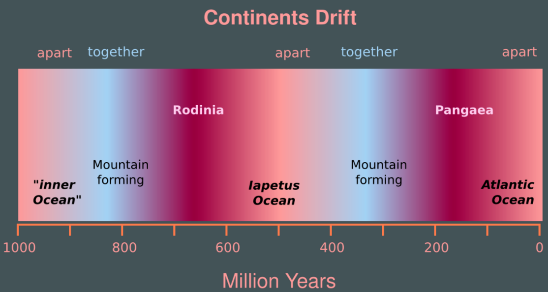
The supercontinent cycle is the quasi-periodic aggregation and dispersal of Earth's continental crust. There are varying opinions as to whether the amount of continental crust is increasing, decreasing, or staying about the same, but it is agreed that the Earth's crust is constantly being reconfigured. One complete supercontinent cycle is said to take 300 to 500 million years. Continental collision makes fewer and larger continents while rifting makes more and smaller continents.
- continental crust
- aggregation
- dispersal
1. Description

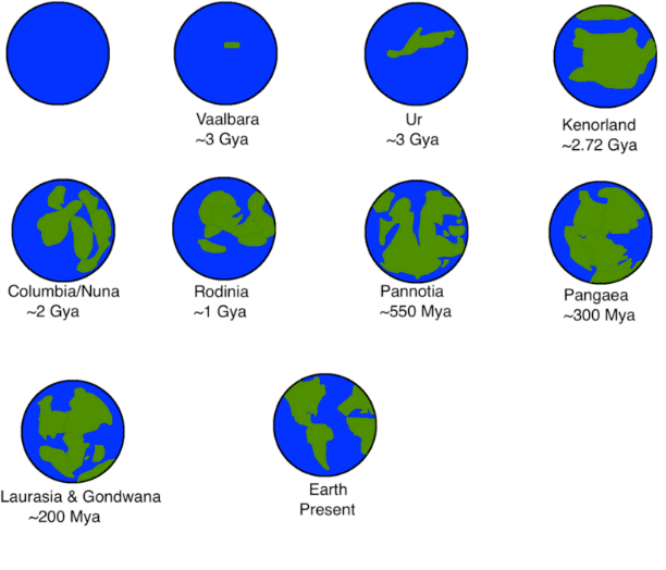
The most recent supercontinent, Pangaea, formed about 300 million years ago (0.3 Ga). There are two different views on the history of earlier supercontinents. The first proposes a series of supercontinents: Vaalbara (c. 3.6 to c. 2.8 billion years ago); Ur (c. 3 billion years ago); Kenorland (c. 2.7 to 2.1 billion years ago); Columbia (c. 1.8 to 1.5 billion years ago); Rodinia (c. 1.25 billion to 750 million years ago); and Pannotia (c. 600 million years ago), whose dispersal produced the fragments that ultimately collided to form Pangaea.[1][2]
The second view (Protopangea-Paleopangea), based on both palaeomagnetic and geological evidence, is that supercontinent cycles did not occur before about 0.6 Ga (during the Ediacaran Period). Instead, the continental crust comprised a single supercontinent from about 2.7 Ga (Gigaannum, or "billion years ago") until it broke up for the first time, somewhere around 0.6 Ga. This reconstruction[3] is based on the observation that if only small peripheral modifications are made to the primary reconstruction, the data show that the palaeomagnetic poles converged to quasi-static positions for long intervals between about 2.7–2.2, 1.5–1.25 and 0.75–0.6 Ga.[4] During the intervening periods, the poles appear to have conformed to a unified apparent polar wander path. Thus the paleomagnetic data are adequately explained by the existence of a single Protopangea–Paleopangea supercontinent with prolonged quasi-integrity. The prolonged duration of this supercontinent could be explained by the operation of lid tectonics (comparable to the tectonics operating on Mars and Venus) during Precambrian times, as opposed to the plate tectonics seen on the contemporary Earth.[3] However, this approach was widely criticized as it is based on incorrect application of paleomagnetic data.[5]
The kinds of minerals found inside ancient diamonds suggest that the cycle of supercontinental formation and breakup began roughly 3.0 billion years ago (3.0 Ga). Before 3.2 billion years ago only diamonds with peridotitic compositions (commonly found in the Earth's mantle) formed, whereas after 3.0 billion years ago eclogitic diamonds (rocks from the Earth's surface crust) became prevalent. This change is thought to have come about as subduction and continental collision introduced eclogite into subcontinental diamond-forming fluids.[6]

The hypothesized supercontinent cycle is overlaid by the Wilson Cycle named after plate tectonics pioneer John Tuzo Wilson, which describes the periodic opening and closing of oceanic basins from a single plate rift. The oldest seafloor material found today dates to only 170 million years old, whereas the oldest continental crust material found today dates to 4 billion years, showing the relative brevity of the regional Wilson cycles compared to the planetary pulse seen in the arrangement of the continents.
2. Effects on Sea Level
It is known that sea level is generally low when the continents are together and high when they are apart. For example, sea level was low at the time of formation of Pangaea (Permian) and Pannotia (latest Neoproterozoic), and rose rapidly to maxima during Ordovician and Cretaceous times, when the continents were dispersed. This is because the age of the oceanic lithosphere provides a major control on the depth of the ocean basins, and therefore on global sea level. Oceanic lithosphere forms at mid-ocean ridges and moves outwards, conductively cooling and shrinking, which decreases the thickness and increases the density of the oceanic lithosphere, and lowers the seafloor away from mid-ocean ridges. For oceanic lithosphere that is less than about 75 million years old, a simple cooling half-space model of conductive cooling works, in which the depth of the ocean basins d in areas in which there is no nearby subduction is a function of the age of the oceanic lithosphere t. In general,
- [math]\displaystyle{ d(t) = \frac{2}{\sqrt{\pi}} a_{\rm eff} T_1 \sqrt{\kappa t} + d_{\rm r} }[/math]
where κ is the thermal diffusivity of the mantle lithosphere (c. 8×10⁻⁷ m2/s), aeff is the effective thermal expansion coefficient for rock (c. 5.7×10⁻⁵ °C−1), T1 is the temperature of ascending magma compared to the temperature at the upper boundary (c. 1220 °C for the Atlantic and Indian Oceans, c. 1120 °C for the eastern Pacific) and dr is the depth of the ridge below the ocean surface.[7] After plugging in rough numbers for the sea floor, the equation becomes:
- for the eastern Pacific Ocean:
- [math]\displaystyle{ d(t) = 350 \sqrt{t} + 2500 }[/math]
- and for the Atlantic and Indian Oceans:
-
- [math]\displaystyle{ d(t) = 390 \sqrt{t} + 2500 }[/math]
where d is in meters and t is in millions of years, so that just-formed crust at the mid-ocean ridges lies at about 2,500 m depth, whereas 50-million-year-old seafloor lies at a depth of about 5,000 m.[8]
As the mean level of the sea floor decreases, the volume of the ocean basins increases, and if other factors that can control sea level remain constant, sea level falls. The converse is also true: younger oceanic lithosphere leads to shallower oceans and higher sea levels if other factors remain constant.
The surface area of the oceans can change when continents rift (stretching the continents decreases ocean area and raises sea level) or as a result of continental collision (compressing the continents increases ocean area and lowers sea level). Increasing sea level will flood the continents, while decreasing sea level will expose continental shelves.
Because the continental shelf has a very low slope, a small increase in sea level will result in a large change in the percent of continents flooded.
If the world ocean on average is young, the seafloor will be relatively shallow, and sea level will be high: more of the continents are flooded. If the world ocean is on average old, seafloor will be relatively deep, and sea level will be low: more of the continents will be exposed.
There is thus a relatively simple relationship between the supercontinent cycle and the mean age of the seafloor.
- Supercontinent = much old seafloor = low sea level
- Dispersed continents = much young seafloor = high sea level
There will also be a climatic effect of the supercontinent cycle that will amplify this further:
- Supercontinent = continental climate dominant = continental glaciation likely = still lower sea level
- Dispersed continents = maritime climate dominant = continental glaciation unlikely = sea level is not lowered by this mechanism
3. Relation to Global Tectonics
There is a progression of tectonic regimes that accompanies the supercontinent cycle:
During break-up of the supercontinent, rifting environments dominate. This is followed by passive margin environments, while seafloor spreading continues and the oceans grow. This in turn is followed by the development of collisional environments that become increasingly important with time. First collisions are between continents and island arcs, but lead ultimately to continent-continent collisions. This was the situation during the Paleozoic supercontinent cycle; it is being observed for the Mesozoic–Cenozoic supercontinent cycle, still in progress.
4. Relation to Climate
There are two types of global earth climates: icehouse and greenhouse. Icehouse is characterized by frequent continental glaciations and severe desert environments. Greenhouse is characterized by warm climates. Both reflect the supercontinent cycle. It is now a short greenhouse phase of an icehouse world.[9]
- Icehouse climate
- Continents moving together
- Sea level low due to lack of seafloor production
- Climate cooler, arid
- Associated with aragonite seas
- Formation of supercontinents
- Greenhouse climate
- Continents dispersed
- Sea level high
- High level of seafloor spreading
- Relatively large amounts of CO2 production at oceanic rifting zones
- Climate warm and humid
- Associated with calcite seas
Periods of icehouse climate: much of Neoproterozoic, late Paleozoic, late Cenozoic.
Periods of greenhouse climate: Early Paleozoic, Mesozoic–early Cenozoic.
5. Relation to Evolution
The principal mechanism for evolution is natural selection among diverse populations. As genetic drift occurs more frequently in small populations, diversity is an observed consequence of isolation. Less isolation, and thus less diversification, occurs when the continents are all together, producing both one continent and one ocean with one coast. In Latest Neoproterozoic to Early Paleozoic times, when the tremendous proliferation of diverse metazoa occurred, isolation of marine environments resulted from the breakup of Pannotia.
A north–south arrangement of continents and oceans leads to much more diversity and isolation than east–west arrangements. North-to-south arrangements give climatically different zones along the communication routes to the north and south, which are separated by water or land from other continental or oceanic zones of similar climate. Formation of similar tracts of continents and ocean basins oriented east–west would lead to much less isolation, diversification, and slower evolution, since each continent or ocean is in fewer climatic zones. Through the Cenozoic, isolation has been maximized by a north–south arrangement.
Diversity, as measured by the number of families, follows the supercontinent cycle very well.[10]
The content is sourced from: https://handwiki.org/wiki/Supercontinent_cycle
References
- Zhao, Guochun; Cawood, Peter A.; Wilde, Simon A.; Sun, M. (2002). "Review of global 2.1–1.8 Ga orogens: implications for a pre-Rodinia supercontinent". Earth-Science Reviews 59 (1–4): 125–162. doi:10.1016/S0012-8252(02)00073-9. Bibcode: 2002ESRv...59..125Z. https://dx.doi.org/10.1016%2FS0012-8252%2802%2900073-9
- Zhao, Guochun; Sun, M.; Wilde, Simon A.; Li, S. Z. (2004). "A Paleo-Mesoproterozoic supercontinent: assembly, growth and breakup". Earth-Science Reviews 67 (1–2): 91–123. doi:10.1016/j.earscirev.2004.02.003. Bibcode: 2004ESRv...67...91Z. http://www.gt-crust.ru/jour/article/view/518.
- Piper, J. D. A. (2013). "A planetary perspective on Earth evolution: Lid Tectonics before Plate Tectonics". Tectonophysics 589: 44–56. doi:10.1016/j.tecto.2012.12.042. Bibcode: 2013Tectp.589...44P. https://dx.doi.org/10.1016%2Fj.tecto.2012.12.042
- Piper, J. D. A. (2013). "Continental velocity through geological time: the link to magmatism, crustal accretion and episodes of global cooling". Geoscience Frontiers 4: 7–36. doi:10.1016/j.gsf.2012.05.008. https://dx.doi.org/10.1016%2Fj.gsf.2012.05.008
- Z.X, Li (October 2009). "How not to build a supercontinent: A reply to J.D.A. Piper". Precambrian Research 174 (1-2): 208-214. doi:10.1016/j.precamres.2009.06.007. https://dx.doi.org/10.1016%2Fj.precamres.2009.06.007
- Shirey, S. B.; Richardson, S. H. (2011). "Start of the Wilson Cycle at 3 Ga Shown by Diamonds from Subcontinental Mantle". Science 333 (6041): 434–436. doi:10.1126/science.1206275. PMID 21778395. Bibcode: 2011Sci...333..434S. https://dx.doi.org/10.1126%2Fscience.1206275
- E. E., Davis; Lister, C. R. B. (1974). "Fundamentals of Ridge Crest Topography". Earth and Planetary Science Letters 21 (4): 405–413. doi:10.1016/0012-821X(74)90180-0. Bibcode: 1974E&PSL..21..405D. https://dx.doi.org/10.1016%2F0012-821X%2874%2990180-0
- Parsons, Barry; Sclater, John G. (1977). "An analysis of the variation of ocean floor bathymetry and heat flow with age". Journal of Geophysical Research 82 (B5): 802–827. doi:10.1029/jb082i005p00803. Bibcode: 1977JGR....82..802P. https://dx.doi.org/10.1029%2Fjb082i005p00803
- Read, J. Fred (2001). "Record of ancient climates can be a map to riches". Science from Virginia Tech. http://www.research.vt.edu/resmag/sciencecol/2001old_weather.html. Retrieved 2011-05-04.
- Benton, Michael J. (23 September 2005). Fossil Record: Quality. John Wiley & Sons, Ltd. doi:10.1038/npg.els.0004144. ISBN 978-0470016176. https://dx.doi.org/10.1038%2Fnpg.els.0004144
