In mathematics, a homothetic behavior is characterized by a transformation of an affine space by a factor λ and results in an invariance of this space form or configuration, albeit its overall scale changes. In this sense, if two objects or parts of those objects have distinct sizes, but conserve the same appearance, they can be considered homothetic. In networks, the occurrence of homothetic behaviors would imply that a section of the network, when modelled independently, ought to retain a certain regularity in their distribution of centrality hierarchies (visual similitude) when compared to a larger section, independently modelled as well, that contains it. Hence, the smaller network maintains its overall proportions (configuration, hierarchies and values) across scales. This visual similitude was perceived while apposing several Normalized Angular Choice (NACH) models, a Space Syntax’ derivative from mathematical betweenness.
Network homotheties, due to their invariability in form and value, can be used as an alternative to extensive network generalization for the construction of large spatial networks. Hence, data maps can be constructed sooner and more accurately as “pieces of a puzzle”, since each individual lesser scale graph possesses a faster processing time.
- Betweenness Centralities
- Homothetic Behaviour
- Networks
Large spatial network analyses and the representation of regional road-infrastructures are scale associated problems. In these instances, scale ought to be interpreted as time, since the models’ processing pace—and, therefore, the cartographic data availability for further assessments—often be constrained by network dimension.
While configurational analyses, such as the in-vogue Space Syntax’ Angular Analysis, are able to construct models with accurate and detailed depictions of road-circulation network properties—such as centrality hierarchies—their methods are not tailored to model region-wide areas. Being focused on the representation of plazas, cities and other small-scale networks, Space Syntax’s developers did not consider these possible time-scale related issues whilst developing its instrumentation. In this sense, Angular Analysis falls under the inevitability of network complexity reduction and requires, as the usual course of action, ulterior adjustments to the available Road-Centre Line (RCL) databases, in the form of generalization processes, to enable efficient spatial modelling. Without a doubt RCL graph generalization is an important and sometimes indispensable step for these network-based analyses, as a reduction in often-excessive polyline vertices numbers will considerably impact computation time-lapses, above all in Space Syntax, due to the angular segmentation preprocessing required by Angular Analysis. However, extensive generalizations of spatial data are accompanied by a trade-off regarding network incompleteness, which is significant whenever the assessment of accurate relations among different territorial scales is the objective (Figure 1). This, in the end, hinders one of the most distinguished features of Angular Analysis—its accurateness in the cartographic representation of configurational properties alongside the real morphologies of urban network-based systems.
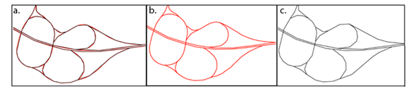
Figure 1. Comparison between (a) non-generalized (b) and generalized (c) road-circulation networks from Tuscan Region Road Graph
From this perspective, the assessment of interactions between cities and regions, an important component for sustainability analysis at the urban scale, becomes unidimensional, given the inability of the analysis to consider and evaluate the whole territorial configurational context in which the cities are embedded. Further improvements in the representation of local-regional relations and road-circulation network representation can serve as guidance for tailored territory-oriented policies that assess economic activity displacement and resilience. Understanding regional movement demands and apposing them to spatial data and models that can assess movement logics related to supply—such as travel-time analysis, activities placement and infrastructure characteristics—enable to precisely determine the location of territorially exposed places. Those areas are susceptible to the under-usage of building stock, or abandonment and divestment conditions, urban phenomena observed and faced in many Tuscan municipalities and, as well, throughout other Italian regions.
Exploring road-circulation networks homothetic behavior, a property found in Betweenness Centrality-based NACH models, could be an alternative to extensive generalization for large-scale networks, and may provide more accurate scale-comparable representations. This property suggests that visual similitudes (homotheties) are present in Betweenness Centrality (NACH) models across scales. Thus, road-circulation networks will possess similar centrality hierarchy distributions and values, forming an actual image of a map section when juxtaposed to a network of greater or lesser scale. The reduction in processing time-lapses that can be attained, due to the use of smaller-sized networks, will be equivalent, or even greater than the gains made through the use of extensive generalization, without the morphological distortions derived from over-simplification.
Correlation tests demonstrated that homothetic behavior occurs with relative regularity across all analyzed territorial scales. In these instances, r-squared correlations indicate that the centralities’ distribution in municipalities models tends to be similar (Figure 2 and 3), both in position and in value, to their respective sections in provincial and regional road-network models.
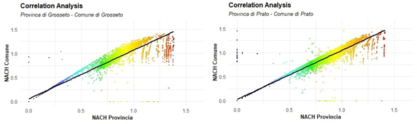
Figure 2. Betweenness Centrality values correlation graphics between Municipal and Provincial NACH models for Grosseto and Prato.
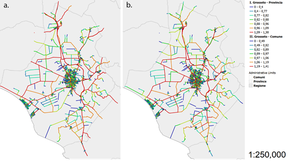
Figure 3. Comparison of Betweenness Centrality hierarchy distribution between the Grosseto Province (Provincia) (a) section and the Grosseto Municipality (Comune) (b) road-circulation network models (NACH).
The same pattern was also observed—and with more evident correlations—for provinces and their respective sections of the regional network Even though the attained correlations denote robust homothetic behavior, distortions are still present, as no r-squared value is equal to one (perfect homotheties) (Figures 4, 5 and 6).
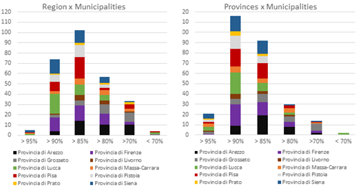
Figure 4. Distribution of municipality r-squared values according to established ranges for region-municipality and province-municipality NACH model correlation.
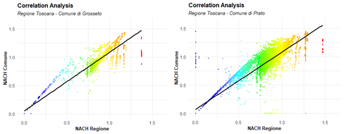
Figure 5. Betweenness Centrality value correlation graphics between Municipal and Regional NACH models for Grosseto and Prato.
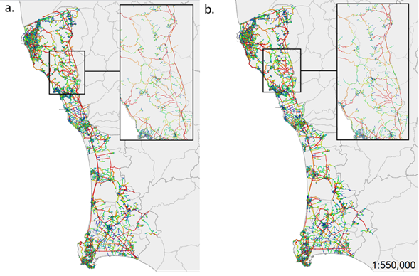
Figure 6. Comparison of Betweenness Centrality hierarchy distribution amid the regional section (a) and the municipality (b) road-circulation network models of the Livorno province.
Investigations about the nature and causes of these homothetic behavior asymmetries amid models revealed that those come, in greater or lesser degree, from edge effects, an implication from the network discontinuities close to systems’ borders, that result from the creation of artificial boundaries—in this case, the section made according to the administrative limits. While edge effects somewhat impact model accurateness, these distortions do not invalidate the homothetic behavior logic observed in core centralities, since beyond edge effects area of influence, the immediate border, models remain substantially similar. Hence, consideration of network homotheties as an alternative to large scale network analyses may allow the construction of region-wide Betweenness Centrality cartographical representations with smaller sections of maps—like pieces in a puzzle—with comparable smaller processing times and higher relative detail.
Further research is required to better understand the formal or mathematical causes that allow Betweenness Centrality to exhibit this homothetic behavior in networks, and to determine whether this property can be used or reproduced for other kinds of centrality measures based on sum, or even for other types of spatial networks. Other research efforts could be directed into the conception of an algorithm capable of compensating for the distortions caused by edge effects on these networks, a problem that, if solved, could aid the exploration of original concepts on fields of theoretical network analysis and applied mathematics. Future studies could also employ the proposed methods—alongside other spatial datasets—as guidelines for the recommendation of territorial policies, which constitute crucial developments for applied research.
This entry is adapted from the peer-reviewed paper 10.3390/su12197925