Your browser does not fully support modern features. Please upgrade for a smoother experience.
Please note this is an old version of this entry, which may differ significantly from the current revision.
Subjects:
Transportation Science & Technology
Tunneling and tunnel equipment should be one of the main disciplines in urban planning and engineering. It is important to provide a solution for all road users, including road users in tunnels, where, for example, navigation is crucial, and its functionality may have implications on traffic throughout the city. However, the most important to ensure are the safety applications, e.g., smooth passing of an emergency vehicle, dissemination of warning information, as well as about the failure in tunnels or tunnel closure. Vehicular communication (V2X—vehicle-to-everything) is one of them.
- C2X
- C-ITS
- connectivity
- dead reckoning
- V2X
- GNSS
- tunnels
1. Introduction
Today, the importance of city management is focused on new technologies, sustainability, social aspects, and complex solutions. It is based on the realization of new cases, architecture improvements, IoT deployment, data connectivity, and integration of these particularities, with the main objective of ensuring acceleration, the knowledge-based approach, future strategies, and sustainable evolution of livable cities [1,2,3]. The importance of livability also lies in the movement, accessibility, social, and environmental aspects that fall within the scope of urban transportation [4]. The hidden but essential parts of the transport infrastructure are the tunnels that ensure smooth traffic and connections between the city districts. Tunnels seem to be the perfect way to achieve the criteria for a smart city mentioned above, but several drawbacks are associated with them, especially from a technological point of view. This hidden part of the infrastructure does not allow common positioning systems [5], their applications, and sometimes data connectivity, and thus the tunnels are smart and also ineffective for many applications at the same time.
In the context of the article, the meaning of infrastructure is related to the tunnel itself (construction), control systems, equipment, and devices implemented in the tunnel, as well as in the surroundings, such as traffic light controllers, variable message signs, informative panels, etc., which are implemented on the access ramps to the tunnel and the tunnel exits.
Tunnels are an essential part of urban engineering and smart city ecosystems. First, due to the impact on traffic in the city [6], and second, due to the wide range of installed equipment that provides the possibility of data acquisition, to regulate the maximum allowed speed or entrance into the tunnel, and thus indirectly the number of vehicles in the city districts [7]. The implementation of the tunnel complex in cities brings many benefits, but the financial aspect of investing in construction and then even more in operation and maintenance is not negligible [8,9,10].
One of the major problems concerning tunnels is the Global Navigation Satellite System (GNSS) availability [11]. Since the tunnel is “hidden”, many applications are limited due to positioning requirements. Some of them only notify the user that the GNSS signal is lost, while other ones are based on statistical methods, computation, usage of external devices for supplementary measurements, communication, etc. [12,13]. The problem of a lack of GNSS signal availability has been occurring in tunnels for many years. Whereas smart technologies, navigation systems, and other applications are growing in popularity together with the trends of smart, resilient, and sustainable cities, the problem with GNSS is also growing and its importance is increasing. For this reason, the problem becomes the issue of how to solve positioning (not only) in tunnels.
For the mentioned reasons, it is necessary to take into account these blind spots in smart mobility and transportation solutions. Tunneling and tunnel equipment should be one of the main disciplines in urban planning and engineering. It is important to provide a solution for all road users, including road users in tunnels, where, for example, navigation is crucial, and its functionality may have implications on traffic throughout the city. However, the most important to ensure are the safety applications, e.g., smooth passing of an emergency vehicle, dissemination of warning information, as well as about the failure in tunnels or tunnel closure. Vehicular communication (V2X—vehicle-to-everything) is one of them [14,15], but it does not work properly in locations where GNSS is not available, and thus the analysis of V2X communication in the tunnel is presented in the article with a focus on assisted positioning methods due to V2X communication requirements in position accuracy and its continuous updating during the data transmission.
Within the research, it was found that the positioning of vehicles in vehicular ad hoc networks (VANETs) is crucial, as well as for the purposes of communication between cars and infrastructure. In normal operation of C-ITS (Cooperative–Intelligent Transport Systems), GNSS-based localization is mainly used. However, in tunnels, the GNSS is limited or unavailable. The proposed research strategies are presented in several articles, for example, New Roadside Units (RSU) Positioning [16] by Malik, which presents a specific positioning approach that could be used for vehicular communication. However, there are no specifics mentioned for tunnels, and in addition, the RSU also requires GNSS as well as on-board units placed in the cars. Similar work [17] is presented by Fouda et al., where the tunnels are considered. The simulated numerical results show the possible improvements for V2X communication. In Wang’s article [18], the RFID-assisted approach is presented, and then the Matlab simulation is established. In Hashmi’s article [19], the fusion model of GPS (Global Positioning System) and non-GPS systems is presented with an emphasis on VANETs. However, the results only show the output of the simulation tool.
For this reason, the experimental analysis of V2X communication based on assisted localization methods was performed under real conditions and is presented in the article. The main goal of the experiment is to verify whether V2X communication could be possible under the conditions using assisted localization methods in the limited GNSS availability environment, for example, in the road tunnel, where V2X communication is very important, especially from a safety point of view. The unique experimental test was carried out in the Blanka tunnel complex in Prague, because the tunnel is long enough to completely lose the GNSS signal (more than 5 km, which is vertically and horizontally divided and contains several intersections directly in the tunnel) and the verification of the C-ITS communication could be applied there. Within the test, the validity of C-ITS messages was constantly verified using the unique V2X software stack adopted in the testing units, so the invalid messages are ignored according to the ETSI standards, e.g., because of the positioning accuracy, and thus the V2X messages are not displayed in the application.
The uniqueness of the whole experiment lies in the fact that the tunnel was closed, which also enabled the testing of standardized scenarios of V2X communication directly in the tunnel, for example, a stationary vehicle use case in the tunnel, which would not be possible during normal operation with real traffic. Experience and needs with tunnel technology in Prague were also taken into account in the most common use cases related to tunnel emergencies. The most common case of extraordinary events is the stationary vehicle (failure, accident, etc.) that evokes the closure of a tunnel or a lane in the tunnel. Another common phenomenon is the emergency vehicles of the police, fire brigade, ambulance, or the intervention of a service vehicle in the tunnel, which also leads to the closure, or restriction of traffic in the tunnel at least. Due to the length of the Blanka tunnel and the junctions inside, the case of a stationary vehicle is the appropriate one for using the precise location, which fails via GNSS-based positioning, that is commonly used in the field of C-ITS and other smart applications. Therefore, the unique C-ITS testing was performed in the tunnel, where positioning was ensured by assisted localization approaches based on Dead Reckoning. The test results may benefit the subsequent operation of C-ITS in places where GNSS availability is limited. Therefore, the pilot test and its methodology were designed with a focus on the verification of whether the C-ITS is applicable and usable in the tunnel, and if so, further testing could be performed in a real traffic scenario with normal traffic flow.
2. Background
2.1. Positioning Approaches
Over the years, several approaches have been developed and applied with the main goal of ensuring additional data for the estimation of an accurate position based on video processing [20], sensor data acquisition [21], 3D accelerometers [22], gyroscope and odometry [23,24], beaconing [25], and other communication methods, such as wi-fi signal strength and fingerprinting [26], etc.
Moreover, various methods, such as Kalman filtering [27], Dead Reckoning [28], Map matching [29], and others, have been devised. These methods enable computation and filtering of input data and provide position refinement. Each of them has a specific value and benefit for certain purposes and usages, and each method calculates the position with an error.
The results of the experimental measurements are mentioned in [30], where the evaluation of GPS, Kalman filtering, and Dead Reckoning is performed and compared to the ground truth reference.
Each of the methods, including GNSS, respectively GPS, show an error. This implies that their combination could be a way to obtain a better accuracy estimation, especially when using Map matching, which is based on the map layout and reference positions in the map. These methods are relevant and are used in mobility solutions and applications, where the position of the vehicle could be calculated and pinned on the map [27,28,29,30]. This can also work in the tunnel, where the path is clearly defined.
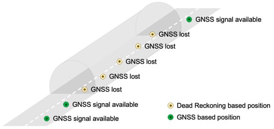
Lastly, in the following figure (Figure 1), a schematic layout of the Dead Reckoning method and its functioning is presented. This functional schema was selected because it directly shows the use case for positioning in the tunnel and also because the Dead Reckoning approach was used within the experimental analysis presented in the article.
Figure 1. Utilization of Dead Reckoning.
2.2. V2X Requirements
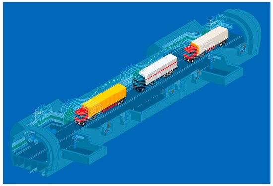
Determining the position of the vehicle, mobile phone, advanced units, and technologies is crucial, especially in traffic and smart mobility solutions. In the field of C-ITS and VANETs, where vehicles should communicate with each other, position accuracy is essential. It is necessary to know where the vehicle is located and to whom it will send information. In the basic principles that are stated, recommended, and standardized for the European region by ETSI (European Telecommunications Standards Institute), for vehicular communication, the accuracy of the position can vary, but in some new cases, such as Platooning (see Figure 2), the information about the time and position is required at intervals of at least 20 times per second [31]. This is practically impossible to achieve on the basis of the received GNSS signal in the tunnel, where no satellites are visible [32].
Figure 2. V2X Platooning [33].
The facts, prerequisites, experiences, and suggestions mentioned above led to the idea to test V2X communication in the tunnel and its surroundings. This was primarily to enhance knowledge about the usage of V2X applications with limited GNSS signal availability, such as tunnels, by practical experiment and measurement, to test further operating characteristics in the tunnel environment in parallel, but most of all, to obtain an answer on how the tunnel is prepared for the upcoming challenges of smart cities.
This entry is adapted from the peer-reviewed paper 10.3390/app12094624
This entry is offline, you can click here to edit this entry!