1. Agricultural Remote Sensing
Agricultural remote sensing is a very useful technology that allows us to observe crops on a large scale in a synoptic, remote, and non-destructive manner. Usually, it involves a sensor mounted on a platform, which could be a satellite, RPA, unmanned ground vehicles (UGV), or a field robot. The sensor collects the reflected or emitted electromagnetic radiation from plants, which is then further processed to produce useful information and products. This information consists of traits of the agriculture system and their variations in space and time. Functional traits have been defined as the biochemical, morphological, phenological, physiological, and structural physiognomies that regulate organism (plant) performance or fitness [
18]. These traits vary from one plant to another and from one location to other, and can be categorized as typological-, biological-, physical-, structural-, geometrical-, or chemical-based in terms of their respective natures. RS provides an effective relation between the radiance of plants and the respective traits to extract useful information, e.g., leaf area index (LAI), chlorophyll content, soil moisture content, etc. Nevertheless, a number of factors, like the crop phenological stage, crop type, soil type, location, wind speed, precipitation, humidity, solar radiation, nutrient supply, etc., need to be known to generate accurate information from RS products. Among others, plant density, organ computing, LAI, green cover fraction, leaf biochemical content, leaf orientation, height, soil and vegetation temperature, and soil moisture are prominent informational products that RS delivers. This information is further processed and used to interpret crop health, disease infraction, irrigation period, nutrient deficiency, and yield estimations.
Weiss et al. [
18] categorized agricultural data retrieving approaches from RS into the following three principal categories:
-
Purely empirical methods: establishing a direct relationship between a measured RS signal and biophysical variables (linear and nonlinear regressions: machine learning).
-
Mechanistic methods: model inversion based on Maxwell’s equations (for radar interferometry and polarimetry), optical and projective geometry (for LiDAR and photogrammetry), and radiative transfer theory (for solar and microwave domains).
-
Contextual methods: processing the spatial and temporal characteristics of captured images using segmentation techniques.
Another way to describe information treatment using RS technology is the preparation of vegetation indices (VIs). Most commonly, VIs calculated using RS, among others, include: normalized difference vegetation index (NDVI) for crop monitoring and empirical studies; soil-adjusted vegetation index (SAVI) for improving the sensitivity of NDVI to soil backgrounds; green normalized difference vegetation index (gNDVI) for estimating the photosynthetic activity; wide dynamic range vegetation index (WDRVI) for enhancing the dynamic range of NDVI; chlorophyll index–green (CI–G) for determining the leaf chlorophyll content; modified soil adjusted vegetation index (MSAVI) for reducing the influence of bare soil on SAVI; optimized soil-adjusted vegetation index (OSAVI) for calculating aboveground biomass, leaf nitrogen content, and chlorophyll content; chlorophyll vegetation index (CVI) for representing relative abundance of vegetation and soil; triangular vegetation index (TVI) for predicting leaf nitrogen status; normalized green red difference index (NGRDI) for estimating nutrient status; visible atmospherically resistant index (VARI) for mitigating the illuminating differences and atmospheric effects in the visible spectrum; crop water stress index (CWSI) for measuring canopy temperature changes and dynamics; and photochemical reflectance index (PRI) for detecting disease symptoms [
7].
Normally sensors used in RS that are for crop monitoring detect the following electromagnetic wave bands, depending on specific objectives [
7]:
-
Thermal infrared band;
-
Red, green, and blue (RGB) bands;
-
Near infrared (NIR) band;
-
Red edge band (RE).
The amplitude of the information retrieved from RS is considerable to support sustainable agriculture capable of feeding a rapidly growing world population. Among the prominent advantages or applications of RS are the identification of phenotypically better varieties, optimization of crop management, evapotranspiration, agriculture phenology, crop production forecasting, ecosystem services (related to soil or water resources) provision, plant and animal biodiversity screening, crop and land monitoring, and precision farming [
8,
18,
19,
40,
41,
42].
2. Sensors
The backbone of RS is the sensors that provide all the basic information, not only of crops, but also of the environment. The quality and yield of the plants is highly dependent on factors such as temperature, humidity, light, and the level of carbon dioxide (CO
2) [
82]. These factors, along with a variety of other parameters, can easily be measured using sensors [
32]. Sensors usually serve for narrow band hyperspectral or broad band multispectral data acquisition, and can be space-borne, air-borne, and ground-based in terms of their respective use in satellites, RPAs, and fields or laboratories, respectively [
40]. Currently, the most commonly used sensors in agricultural RS include synthetic aperture radar (SAR), near-infrared (NIR), light detection and ranging (LiDAR), fluorescence spectroscopy and imaging, multispectral, and visible RGB (VIS) sensors; thereby studying a variety of parameters according to needs.
Table 1 lists the RS sensors, grouped under main categories, with their respective applications in agriculture. For an elaborated use of different sensors in agriculture, the study by Yang et al. [
83] is recommended.
Table 1. Principal categories of remote sensing (RS) sensors with their respective functions in agricultural studies.
| Sensor |
Purpose |
Ref. |
| Synthetic aperture radar (SAR) |
Crop classification, crop growth monitoring, and soil moisture monitoring. |
[84] |
| Visible RGB (VIS) |
Vegetation classification and estimation of geometric attributes. |
[42] |
| Multispectral and hyperspectral |
Physiological and biochemical attributes (leaf area index, crop water content, leaf/canopy chlorophyll content, and nitrogen content). |
[85] |
| Fluorescence spectroscopy and imaging sensors |
Chlorophyll and nitrogen content, nitrogen-to-carbon ratio, and leaf area index. |
[86] |
| Laser/light detection and ranging (LiDAR) |
Horizontal and vertical structural characteristics of plants. |
[87] |
| Near-infrared (NIR) |
Crop health, water.
Management, soil moisture analysis, plant counting, and erosion analysis. |
[7] |
Ground-based sensors have long been in use, i.e., since the third industrial revolution, and those of the current era are wireless sensor technologies (WSTs). WSTs use radio frequency identification (RFID) and wireless sensor networks (WSN) [
88]. The 5th industrial revolution has also resulted in rapid research and development in terms of smaller sensing devices, digital circuits, and radio frequency technology. The principal difference between RFID and WSN is that WSN permits multihop communication and network topologies, whereas no cooperative capabilities are offered by RFID devices. Now, WSNs are, not only the base of precision agriculture, but also that of precision livestock farming and precision poultry farming. RFID, which was basically developed for identification purposes, is currently being used for developing new wireless sensor devices. These systems comprise of a number of tiny sensor nodes (consisting of three basic components: sensing, processing, and communication) and few sinks. Each wireless sensor node can be employed in the desired crop field and are linked through a gateway unit, communicating with other computer systems via wireless local area networks (WLAN), local area networks (LAN), the Internet, wireless wide area network (WWAN), or controller area network (CAN), making use of standard protocols (i.e., general packet radio service (GPRS) or global system for mobile communication (GSM)) [
10]. Given the maturity and potential of these technologies, they seem to be promising technologies for agricultural remote sensing. Another reason for WSN implementation in agriculture is a prerequisite of DSS is that it needs processed information rather than sensor-taken raw data. Therefore, WSNs using a meshed network of wireless sensors collect, process, and communicate the data for DSS, thus ensuring a controlled system [
45].
WST applications in the agricultural sector have gone through considerable research and it is found to be very common in greenhouse and livestock monitoring applications. These applications are becoming more common by the day. Additionally, it is also important to consider challenges, e.g., weather conditions, reliable link quality above crop canopies, and coverage, that are faced when implementing radio frequencies in crop fields. It is also important in remote sensing that there be a mechanism of erroneous measurement detection, thereby rectifying wrongly collected data. Actual examples of the applications of WST, although few, include creating a mobile WSN connecting tractors or combining harvesters with other vehicles, enabling them to exchange data [
10]. Recently, a customized WSN was used to detect fungal disease in a strawberry production using a distributed mesh network of wireless mini weather stations, equipped with relative humidity, temperature, and leaf wetness sensors. Similarly, other studies included the implementation of WSN in vineyards for precision viticulture and addressed heat summation and potential frost damage [
10]. Similarly, various other studies on their application in irrigation, greenhouse, and horticulture domains have been reported [
45]. However, it is important to consider that there is an immense need for a standard body to regulate agricultural sensor device development as well as their subsequent implementation in modeling and DSS.
These technologies have been in constant transition over the past few years, e.g., updating various ISO (International Organization for Standards) standards for RFID (ISO/IEC 18000, ISO 11784, etc.), Bluetooth, Wibree, WiFi, and ZigBee for WSNs [
88,
89]. Various studies have reported on the use of these technologies, such as the use of ZigBee for precision agriculture (elaborated by Sahitya et al. [
90]). A substantial improvement in WSN for subsequent incorporation into satellites and RPAs will certainly augment the efficiency of these platforms. For a summary of some of the commonly implied sensors in agriculture that provide data about plant, soil, and climate conditions, the study by Abbasi et al. [
89] is recommended.
A lot of renowned companies and institutes, including NASA, are involved in the production of novel and efficient sensors. For example, the Microsoft Kinect sensor developed in the last decade shows remarkable potential for rapid characterization of vegetation structure, as reported previously [
91]. For a comprehensive study on the latest advances in sensor technology applied to the agricultural sector, the study by Kayad et al. is recommended [
26].
Joint ventures by governments and academic institutes, apart from those of the private sector, in the implementation of sensor technology can bear rapid and efficient results, such as the Center of Satellite Communication and Remote Sensing at Istanbul Technical University (ITU), and the Turkish Statistical Institute joining hands to realize the sensor-driven agricultural monitoring and information system (TARBIL) project [
92]. Various sensors are being currently invented and developed, through private firms and joint ventures, based on wireless technology for subsequent applications in viticulture, irrigation, greenhouse, horticulture, pest control, fertilization, etc. [
89], but this also highlights the necessity of some regulating and standard bodies.
Similarly, John Deere, a leading farming equipment company, is currently undertaking various IoT projects, including sensor-fitted autonomous tractors, capable of yield estimation features, among various other features [
93]. Apart from the industrial perspective, a great deal of research in the academic domain is also on the rise in this sphere. These technologies are promising for efficient and sustainable farming, which is basically expected in the 5th industrial revolution.
Satellites and RPAs are two prominent platforms of RS technology and therefore, it is important to consider their use in the 5th industrial revolution, mainly focusing on the agricultural sector. Various studies have highlighted the limitations of the one or the other, but both are beneficial in general. In this regard, their current and future roles in on-board sensors and cameras are reported here.
2.1. Satellite
One of the oldest and main platforms of RS technology is the satellite. In 1957, the first ever satellite: Sputnik 1, weighing 183 pounds and the size of a basketball, was launched into space by the Soviet Union [
94]. It has been over 40 years since satellite systems became operational, but a milestone in RS was achieved with the creation of normalized difference vegetation index (NDVI) maps, providing information about land cover, phenology, and vegetation activity, using advanced very high resolution radiometer (AVHRR) [
35]. In terms of improved performance, considering geometric, spectral, and radiometric properties, the moderate resolution imaging spectroradiometer (MODIS) significantly helped with remote sensing. MODIS instruments laid the foundation of a new era in remote sensing after their launch in 1999, providing 1-km spatial resolution GPP products [
35].
Numerous satellites had been launched in the past two decades with various spatial and temporal resolutions [
95], which proved to be the basis of the 5th technological revolution. Today, various privately-held and government-managed satellites harboring versatile sensors are an efficient foundation to RS, thereby providing huge sets of interpretable data and information. For example, Spain started its “National Remote Sensing Plan (PNT)” in 2004, aimed at data provisioning for various Spanish public administrations [
96]. Although, it is important to bear in mind that this domain was envisaged with a little boost in 2008, when Landsat (US operated satellites) images were set freely accessible (under open license), and the launch of Sentinel 1A and Sentinel 2A satellites, in 2014 and 2015, respectively, under the Copernicus Program, further increased the momentum of RS. The Sentinel constellation is the part of Copernicus program that was launched by the European Commission and the European Space Agency (ESA). As more than 30 satellites provide data for this program, it is of great use to scientists to analyze the freely available data regarding agriculture. In addition, a separate database, titled “Copernicus Academic”, of the Copernicus program also facilitates the training and better utilization of satellite data [
97]. Similarly, the Landsat program, launched by the United States as a joint venture between the National Aeronautics and Space Administration (NASA) and the United States Geological Survey (USGS), also offers free access to high-resolution images. The present needs are to wisely utilize these free accessible data to achieve ambitious agricultural goals. Furthermore, space-borne hyperspectral missions, such as ZY1-AHSI, PRISMA, DESIS, and GF5-AHSI, which launched recently, or are planned to be launched in upcoming years, such as SBG, CHIME, and EnMAP, are expected to augment agricultural monitoring in terms of vegetation functions and traits. It is imperative to address recurring limitations, such as soil background and canopy structure interference, signal variations in optical vegetation properties, and poor discrimination of functional traits due to lesser narrow spectral regions [
2].
Recently, a cloud-free crop map service utilizing radar and optical data from Sentinel-1 and -2, respectively, was announced under a joint venture by two private companies i.e., VanderSat and BASF Digital Farming GmbH, thereby providing daily maps of field-scale crop biomass [
98]. This advancement is a remarkable breakthrough in RS from satellites, as it has been a great challenge since the beginning of this technology. Recent advances in this technology are making it a fine and efficient technology through the use of machine learning. A study conducted by Mazzia et al. [
99] reported a novel strategy for refining the freely available photos from satellites to minimize the errors often encountered by their low or moderate resolutions. This is an excellent example of the use of blended technology, where the authors trained a convolutional neural network using high-resolution images from RPA and then derived the NDVI to interpret the low- or moderate-resolution satellite images of vineyard vigor maps. Among other uses of this RS platform, one is the construction of historical maps of crops, as these play a significant role in crop prediction estimation and related simulations. Recently, a study established the relationship between MODIS-derived NDVI and the grain yields of wheat, barley, and all cereals for 20 European countries (including Austria, Belgium, Denmark, France, Germany, Ireland, Sweden, the United Kingdom, etc.). After analyzing the data from 2010 to 2018, a higher percentage of cereals was reported; 35% for arable land. The efficacy of yield prediction in relation to NDVI and cereals was reported as trustworthy over a good time period of 4 months [
100]. More studies of this nature on a global scale are needed to strengthen the agriculture of today.
Implementation of existing technological tools is also very important. For instance, Google Earth Engine (GEE) offers diverse services in this domain for the agricultural industry. GEE facilitates product downloading of various satellites imagery (Landsat, Sentinels, MODIS, etc.) along with cloud-based management, by granting access either through an academic email or simply a standard Gmail account to their servers. Processing very large geospatial datasets often makes the process slow and difficult. In this regard, GEE, a cloud-based platform, facilitates access to high-performance computing resources without any cost. Systematic data products and interactive applications can be developed based on GEE once an algorithm is developed—thereby reducing the complexities of programming and application development [
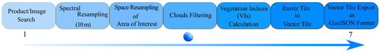
45]. A stepwise illustration for product downloads from GEE is presented in
Figure 1, although the final exported product can be different from this illustration, based on the needs and preferred format.
Figure 1. A stepwise illustration (1 to 7) of processing and downloading satellite imagery products from Google Earth Engine (GEE).
A practical example of benefiting from free services GEE is presented as the construction of vegetation indices (VIs) maps for olive grove trees located at Guadahortuna (Granada, Spain) (Figure 2). Sentinel-2 images, between July 2020 and February 2021, were accessed through GEE, at a resolution of 10 × 10, and were processed to generate NDVI (as indicated in the below formula) vector tiles, followed by their export into GeoJSON format. The GeoJSON format is user friendly and generates data in the form of a table where each pixel represents a file with its NDVI value, which is quite handy to work with.
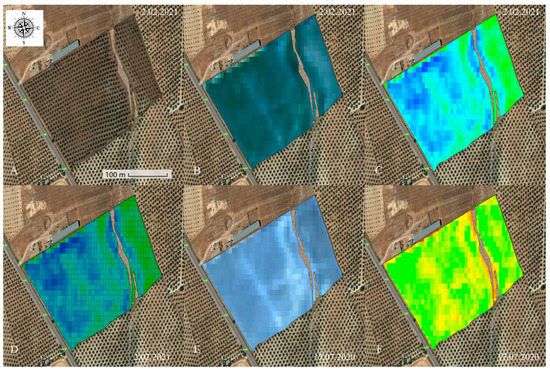
Figure 2. Sentinel-2 images accessed through Google Earth Engine (GEE). (A) Area of interest, (B) RGB field composition, (C) NDVI raster tile, (D) NDVI vector tile, (E) RGB field composition, (F) NDVI raster tile (Images facilitated by Graniot).
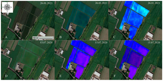
Likewise, another practical example of this nature is the data acquisition, via GEE, for a parcel of vineyard crop situated at Reggio Emilia (Emilia-Romagna, Italy) (
Figure 3). In both of these examples, NDVI was calculated using the following formula:
where NIR is the near-infrared band and the VIS is the visible red. Bands 8 and 4 of Sentinel-2 were used given their desired spatial resolution of 10 m as well as their spectral range (e.g., bands 8 and 4 measure NIR and red spectral bands, respectively) to calculate the NDVI. These serve as an example of free data acquisition and processing; the future promises enormous possibilities. The only need is to make use of such freely available resources for academic, as well as real-world, applications.
Figure 3. Sentinel-2 images accessed through Google Earth Engine (GEE). (A) Area of interest, (B) RGB field composition, (C) NDVI raster tile, (D) RGB field composition, (E) NDVI raster tile, (F) NDVI vector tile (Images facilitated by Graniot).
Another important aspect of using satellite technology is the digital boundaries of crop fields that are a pre-requisite. Areas with intensive agriculture have solved this, but, for small crop areas (>1 ha), it persists. The 5th revolution is playing its part here. Recently, a novel method, “DESTIN”, of crop field delineation was reported with an accuracy of 95–99%, fusing temporal and spatial information acquired from WorldView and Planet satellite imagery [
101]. Such types of studies are opening up the way for digitalizing agriculture and making it sustainable. This new era is not just about processing acquired data it is also about optimizing it for improved-quality products. For example, a recent study on formulating optimal segmentation parameters to obtain precise spatial information of agricultural parcels that normally suffer over- or under-segmentation is an evident demonstration of this idea [
102]. This is not just limited to the optimization of satellite imagery, it is a way to achieve automation and implementation of these technologies on all scales.
2.2. Remotely Piloted Aircrafts (RPAs)
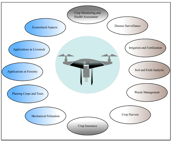
A rise in the use of this technology has been seen over the past decade given its worth as an integral part of RS technology. Intensive research has been conducted using RPAs, considering their application in crop monitoring, disease surveillance, soil analysis, irrigation, fertilization, mechanical pollination, weed management, crop harvest, crop insurance, tree plantation, etc. [
7] (
Figure 4), which obviously hints towards their remarkable potential in the agricultural sector.
Figure 4. A schematic diagram of RPA application in agriculture.
The first use of RPAs in agriculture was reported as back as 1986 for monitoring Montana’s forest fires [
7]. This 5th revolution is anticipated to make more frequent use of RPAs in farming. According to an estimate, RPAs and the agricultural robotics industry could be worth as much as 28 billion dollars by 2028 and up to 35 billion dollars by 2038 [
103].
The use of RPA imagery consists of mission or flight planning, data collection, data processing, and information report generation. Several free resources are available for each of these purposes. For example, QGroundControl is an open-source software that can act as a ground control station (GCS) for RPAs. Similarly, several user-friendly open-source software titles are available in the market for image processing, orthomosaic assembly, digital surface model (DSM), and digital elevation model (DEM) constructions. Open Drone Map (ODM) is a prominent example of this, and offers creations and visualizations of orthomosaic, point cloud, 3D models, and other products [
7]. RPAs offer better resolutions and flexibility of use over satellite imagery. A few such desired features help to monitor the most important crop parameters: nitrogen (N) and chlorophyll contents [
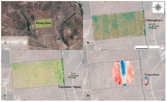
36]. For example,
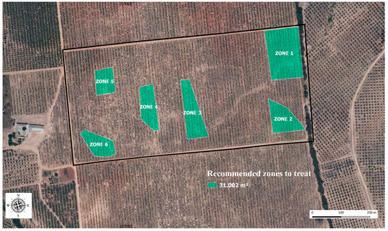
Figure 5 shows an overview of the practical applications of RPAs to acquire Vis, such as NDVI, normalized difference red edge (NDRE) and thermal maps. A Yuneec Typhoon H hexacopter RPA, flown at a 100-m height, equipped with a multispectral camera (parrot sequoia) and a thermal sensor (Yuneec CGOET) was used to monitor olive crops in Cordoba, Spain. After processing the images, treatment zones were indicated depending upon the vegetation vigour, stress, and N content (
Figure 6).
Figure 5. Vegetation index (VIs) maps generated through Parrot Sequoia (a multispectral camera) and Yuneec CGOET (a thermal sensor) mounted on Yuneec Typhoon H hexacopter RPA. (A) Crop area studied. (B) Map of “chlorophyll a” content based on NDRE. (C) Map for vegetation status generated based on NDVI. (D) Thermal map established using Yuneec CGOET. (Images facilitated by MCBiodrone).
Figure 6. A set of field zones recommended for treatment based on the vegetation indices (VIs) maps, generated using a parrot sequoia and Yuneec CGOET mounted on a Yuneec Typhoon H hexacopter RPA for olive crops (image facilitated by MCBiodrone).
Quite a number of studies have reported on various aspect or uses of RPAs but it is interesting to learn what this new era means for one of these RS technologies. New research is being based on artificial intelligence to derive more detailed information about growth, yield, disease, and automation. For example, use of wireless sensor technology and control automation is on the rise in agriculture [
104,
105,
106]. Some of the representative studies with respect to principal applications of RPAs in agriculture are summarized in
Table 2.
Table 2. A summary of a few representative studies for principal agricultural applications of RPAs. (The purpose of citing these references is impartial and is not confined to these studies only).
| RPA Application Area |
Reference |
| Crop growth and monitoring |
[7,108,109,110,111] |
| Crop scouting |
[7,112] |
| Disease detection |
[113,114,115,116] |
| Bird pest surveillance |
[117,118] |
| Irrigation and fertilization |
[111,112,115,116,119,120,121,122,123,124] |
| Soil and field analysis |
[7,108,112,125] |
| Weeds management |
[112,116,120,126] |
| Crop harvest |
[112,127,128] |
| Crop insurance |
[112,114,116] |
| Mechanical pollination |
[7,116,129,130] |
| Forestry |
[131,132,133,134,135] |
| Livestock |
[112,114,116,120,130,136,137] |
One of the prominent features of this technology is its higher resolution than the satellite imagery—offering up to 0.2 m of spatial resolution, which is approximately 40,000 times better resolution that means more and high-quality information can be extracted from these images. Furthermore, laser imaging detection and ranging (LiDAR) systems are using this technology to pave the way towards building 3D maps of plant canopy, soil, and field analysis, which are crucial factors for yield estimation, irrigation, and nutrients estimation, such as for N [
7]. Nevertheless, impeding metrological conditions, local and national regulations, limited spatial coverage due to battery or payload limits, along with a lack of standard procedures for inflight calibration of RPA sensors [
18,
107] are few of the constraints of this platform.
Likewise, it is also important to consider regional and national regulations for operating RPAs, although agricultural applications of RPAs do not invoke substantial risks for people. Government bodies are trying to cope with such regulations, but there is plenty of room for growth. In Europe, the European Union Aviation Safety Agency (EASA) presented legislative framework: “Easy Access Rules for Unmanned Aircraft Systems” (Regulations (EU) 2019/947 and (EU) 2019/945), in 2019, for RPA operations and it went into effect from 31 December 2020 [
138]. The three principal categories established under this legislation are presented in
Table 3. Safety of people, security, privacy, and data protection were the principal parameters considered for establishing these regulations. Nevertheless, most countries are struggling to establish standard regulations, and this requires urgent attention. A general list of RPA laws and regulations can be consulted in [
139].
Table 3. Three categories established by European Union Aviation Safety Agency (EASA) for operating RPAs.
| Sr. |
Category |
Description |
| 1 |
Open |
Not requiring any prior operational declaration or authorization. |
| 2 |
Specified |
Requiring an authorization by the competent authority except for standard scenarios. |
| 3 |
Certified |
Requiring certification by the competent authority. |
This new era is of the Internet of Drones (IoD), where a fleet of drones is deployed, controlled through a ground station server (GSS) via a wireless channel, to harvest the desired data. Currently, research is being undertaken to explore these possibilities for remote areas, where there is no Internet connection. For example, a recent study reported on the possibility of using a cellular network for this purpose [
140]. An interesting study by Prasanna and Jebapriya [
141] on the use of RPAs in smart agriculture, based on IoT, is highly recommended, where the possibilities of this novel technology with their practical examples are discussed. Similarly, novel applications of RPAs can also enrich RS technologies; for example, very recently, an RPA was used as a mobile gateway for a wireless sensor network (WSN), establishing a 24-m flying height and a 25-m antenna coverage provided maximum node density [
142]. In the same way, the benefits of drone centimeter-scale multispectral imagery were investigated in sugar beet crop to improve the assessment of foliar and canopy parameters; five important structural and biochemical plant traits were reported, highlighting the importance of drone imagery for centimeter-scale characterization [
4]. RPAs are already used for capturing videos and photos under specific flight plans, as such, setting an RPA as a node for a WSN is an efficient way to fully benefit from this RS tool.
Despite the appeal of IoD, security may be a recurring issue in upcoming years; large companies are already at the brink of this issue. For this reason, thorough research in this domain is recommended to ensure a reliable application of RS. A recent study undertaken on this aspect of technology offers the implementation of blockchain and smart contracts to safeguard data, which are then archived through IoT-enabled RPAs and sensors, with their respective deployment considerations [
143]. Alternative and economical solutions are urgently required to address these issues.
2.3. Satellite and RPAs: A Complementing System
The use of RPAs versus satellites is often debated in the context of their agricultural applications. Nevertheless, the choice of any of these RS platforms is highly subjective to the needs of farmer and the crop to be studied. However, a minor comparison of these is presented considering their usefulness in RS.
Limited battery life and flight time hinder extensive spatial coverage using RPAs, despite being regarded as optimal for providing robust, reliable and efficient crop phenotyping [
144]. RPAs offer lower operational costs; however, for large amounts of data (to cover larger areas), data processing costs increase exponentially. Similarly, flexibility with flying times and the significant resolution of RPA imagery are desirable characteristics over satellite imagery [
7].
On the other hand, freely accessible satellite data are gaining popularity. Even so, these freely available data come with coarser spatial and temporal resolutions (with the exception of a few commercial satellites), and is being used to generate VIs. In this regard, AI offers leverage to fine-tune coarser satellite data based on high-resolution drone data [
5]. Moreover, a large dataset for training AI models, despite poor quality or noisiness, generates substantial results compared to smaller datasets, indicating the importance of huge datasets obtained through satellite imagery [
5]. This is why big data holds a remarkable position in this regard. For example, a previously reported study demonstrated the effectiveness of deep learning associated with the availability of large and high-quality training samples [
145]. Furthermore, crop simulation models can be generated beforehand from these data for respective agronomic measures and crop yield estimations. Therefore, a complementing system based on these two RS platforms can supplement the efficiency of RS products.