Your browser does not fully support modern features. Please upgrade for a smoother experience.
Please note this is an old version of this entry, which may differ significantly from the current revision.
Subjects:
Geochemistry & Geophysics
North Macedonia is a landlocked country in the central part of the Balkan Peninsula between 40°50′ and 42°20′ north latitude and between 20°28′ and 23°05′ east longitude, with an area of about 25,700 km2.
- chemical elements
- distribution
- pollution
- soil
- North Macedonia
1. Introduction
The impact of humans on the biosphere is extensive and complex and, in most cases, has led to irreversible changes. All human-induced changes disturb the natural balance of ecosystems as they have evolved over a long period. Therefore, in most cases, these changes lead to a degradation of the natural environment for humans. Although the human impact on the biosphere dates back to the Neolithic period, the problems of ecosystem degradation through pollution have intensified in the last few decades of the 20th century. Most of the chemical elements necessary for life on Earth are mainly supplied from the soil above the lithosphere. The content of elements in plants often correlates with their presence in the surrounding soils. Most of the chemical elements that are essential for human life are also essential for plants. However, the concentrations of most elements that can be harmful to humans are not toxic to plants, as they have adapted to such concentrations [1,2]. The consumption of energy and mineral resources leads to the contamination of the biosphere with potentially toxic elements (PTEs). Anthropogenic environmental changes, especially those associated with contamination, lead to environmental degradation. The most potentially hazardous PTEs for the biosphere are As, Cd, Cr, Cu, Hg, Mo, Ni, Pb, Se and Zn. However, elements, such as Ag, Au, Be, Mn, Sb, Sn, Tl, U and V, can be hazardous to the environment if they are released in excessive quantities [3,4,5].
Soil is crucial for the survival of humanity, which is closely linked to its productivity. Soil acts as a filtering, buffering, storage and transformation system and protects against the effects of heavy metal pollution in groundwater. Soil is the most important source of chemical elements for plants, both in the form of micronutrients and pollutants [2]. Due to geological and climatic influences, soils have very different properties. Soils have a unique structural feature that distinguishes them from pure earth materials and serves as the basis for their classification: a vertical sequence of layers formed by the combined action of percolating water and living organisms [1].
The problem of the destruction of ecosystems through pollution became increasingly acute towards the end of the 20th century. The rapid increase in PTE concentrations in the environment is usually accompanied by the development of utilisation technologies. Soils contain chemical elements of different origins: lithogenic elements, which originate directly from the lithosphere; geogenic elements, which are of lithogenic origin but whose concentration and distribution in the soil layers are altered by paedogenetic processes; or anthropogenic elements, which originate from direct or indirect anthropogenic activities. The behaviour of chemical elements in the soil and, thus, their bioavailability differ depending on their origin and soil conditions as well as their chemical and physical properties. Regardless of the chemical form of the anthropogenic elements in the soil, their availability to plants is significantly higher than that of elements of geogenic origin. In several regions of the world, soils are exposed to increasing mineral fertilisation, pesticide use, waste disposal and industrial pollution. All these human activities affect both chemical and physical soil properties and lead to changes in the behaviour of chemical elements in soils [1,6,7,8,9]. The behaviour of elements during weathering and paedogenetic processes, the basic soil-forming processes, is closely related to their geochemical properties. Most elements have a lithophilic character [10,11]. Paedogenetic processes occur simultaneously with weathering processes; usually, these different processes are closely related.
The content of chemical elements in soil materials from natural and contaminated sites shows great variability, both horizontally and vertically. The heterogeneity of soils, especially at the micro level, leads to considerable problems when taking representative soil samples. This affects the reproducibility and comparability of analytical data, which are very important for assessing the background content of chemical elements in soils. Although, today, there is no truly pristine state of PTEs in soils even in remote regions, some values of PTEs in “uncontaminated” soils are used as reference values for the assessment of soil contamination [2].
The terms contamination and soil pollution are used synonymously. Soil contaminated with PTEs is only considered polluted if a threshold concentration is exceeded, and biochemical and biological processes are adversely affected [12]. The main sources of inorganic substances are industrial activities, such as mining and smelting of metal-bearing ores, brick and pipe manufacturing, cement, ceramic and glass production, electricity generation, fossil fuel combustion, nuclear reactors, municipal waste incineration, agricultural practises, such as soil amendment by sewage sludge, manure, mineral fertilisers and pesticides, fumigation, traffic and urban pollution, cosmic particles and long-range transport of pollutants [2,3].
Soil has recently become the subject of numerous studies, some of which deal with large areas. For example, Salminen et al. [13] and De Vos et al. [14] produced the first Geochemical Atlas of Europe as part of the FOREGS (Forum of European Geological Surveys) Geochemical Baseline Programme, which contains data on 63 elements in about 800 topsoil and subsoil samples. In 2014, Chemistry of Europe’s Agricultural soils (in which North Macedonia participated) was published by Reimann and the GEMAS study group (Geochemical Mapping of Agricultural and Grazing Land Soil), which is based on the geochemical analysis of agricultural and grazing soils [15,16]. There are also numerous studies on soil pollution at the national or regional level [17,18,19,20,21,22,23,24,25,26,27,28,29,30,31,32,33,34,35,36,37,38,39,40,41,42,43,44,45,46,47,48,49,50,51,52,53,54,55].
Regional soil contamination occurs mainly in industrial regions and in the centres of large settlements, where factories, traffic and municipal waste are located [1]. Due to the heterogeneity and constant change of urban areas, it is necessary to understand the natural distribution of PTEs and the methods by which they can be distinguished from man-made anomalies in nature. The natural background of the content of PTEs in soil is variable, which means that higher levels of some elements may be normal in one region but abnormal in another. However, in cases where industrial enterprises, particularly mining and smelting operations, are located close to cities, pollution may increase. Recently published works have shown that mining and smelting activities lead to enormous soil pollution [56,57,58,59,60,61,62,63,64,65,66,67,68,69,70,71,72,73,74,75] and that the most serious soil pollution is a consequence of Pb-Zn mining and smelting activities [64,67,76,77,78,79,80,81,82] as well as similar activities for copper, arsenic and antimony [42,51,52,53,54,55,65,70,71,72,73,74,75,79,80,81,82,83,84,85,86,87,88] or coal-fired power plants [89].
North Macedonia first participated in the UNECE ICP Vegetation Programme–Heavy Metals in European Mosses [90,91] in 2002 (survey 2000/2001) and again in 2005, 2010, 2013, 2015 and 2020, in which the atmospheric deposition of trace elements was investigated using samples of terrestrial mosses. The results of these studies in North Macedonia indicate a deterioration in air quality with regards to PTE pollution [92]. The main emission sources are metallurgical activities, power plants and mining. Therefore, additional studies were conducted in the areas with the highest PTE pollution of various environmental media.
2. Geographic Description of North Macedonia
North Macedonia is a landlocked country in the central part of the Balkan Peninsula between 40°50′ and 42°20′ north latitude and between 20°28′ and 23°05′ east longitude (Figure 1), with an area of about 25,700 km2. According to the 2022 census, North Macedonia has a total population of 1,830,000 (2022 census). North Macedonia is divided into eight statistical regions: Skopje, Pelagonia, Polog, Vardar, eastern, southeastern, northeastern and southwestern.
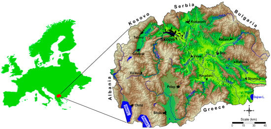
Figure 1. Topographic map of North Macedonia.
North Macedonia is geographically bounded by a central valley formed by the Vardar River and framed by mountain ranges, and the terrain is mostly rugged.
About two-thirds of the country’s territory is mountainous; they belong partly to the old Rodope Group in the eastern part and to the young Dinaric Group in the western part of the country. The eastern mountains are generally lower than 2000 m, while the Dinaric Group over 2500 m high, with Golem Korab, 2764 m, as the highest peak in North Macedonia.
Valleys and plains cut through the mountainous relief structures and cover about a third of the country. The most pronounced valleys are those along the Vardar River, including the Skopje Valley (1840 km2), while the largest plain in North Macedonia is the Pelagonian Plain in the southwest, which covers an area of about 4000 km2 at an average altitude of 600 m. North Macedonia also has scenic mountains, belonging to two different mountain ranges: the Šar Mountains (Dinaric Mountains) and the Osogovo–Belasica mountain chain (Rhodope Mountains) [28].
Due to the characteristic natural and geographical conditions, North Macedonia has two distinct climatic zones: a modified Mediterranean climate and a temperate continental climate. It also features two distinct seasons: cold, wet winters and dry, hot summers, associated with the transitional seasons of spring and autumn [93]. The complex relief structure and differences in altitude significantly alter the Mediterranean influence on the climate. The average annual temperature depends mainly on the altitude of the respective areas; the average annual variation can be up to 20 °C. In the mountain regions, the average annual temperatures are relatively low and range between 4.7 °C (1750 m) and 8.2 °C (1230 m). The highest average annual temperature of 14.5 °C is found in the lower reaches of the Vardar, which is influenced by the Aegean Sea.
The annual rainfall in North Macedonia is very unevenly distributed, with the lowest amounts, often less than 500 mm, falling in the central part of the country. Areas with higher rainfall are Skopje, Kumanovo and the Kočani-Radoviš valleys, with an average rainfall of 500–550 mm. The highest amounts of precipitation were found in the Debar Valley (870 mm) and in the mountainous regions of Bistra and Šar Mountains with over 1000 mm.
North Macedonia is rich in minerals, with deposits of various metals (Cr, Cu, Fe, Pb, Zn, Ni and Mn). Based on these mineral deposits, three mines for lead–zinc ore, one for copper ore and mines for iron, nickel and chrome ore have been opened in the past. In addition, smelters have been built for the extraction of various metals: iron and steel in Skopje, ferronickel in Kavadarci, ferrochromium and ferrosilicon in Jegunovce, and lead and zinc in Veles. The country also has gypsum, limestone, marble, lignite and granite mines.
Based on previous studies, it has been established that North Macedonia has a complex geology, comprising many geological formations of different ages and geological composition, which has led to a great variety of soil types. From a tectonic point of view, North Macedonia comprises six major tectonic units (Figure 2A), including the Vardar Zone (VZ) (Figure 2, IV) in the central region, the Pelagonian Massif (PM) (Figure 2, III), West-Macedonian Zone (WMZ) (Figure 2, II), a small part of the Cukali-Krasta Zone (CKZ) (Figure 2, I) in the west, the Serbo-Macedonian Massif (SMM) (Figure 2, V) and the Kraishtide Zone (KZ) (Figure 2, VI) in the east of the country [28,94,95,96,97].
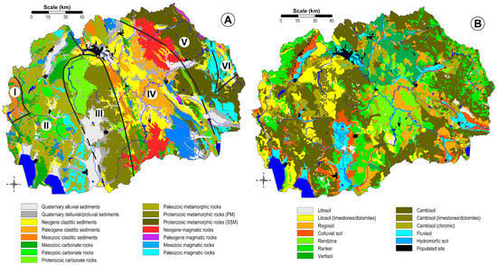
The Cukali-Krasta Zone (CKZ) is mainly distributed in Albania, with a small part in North Macedonia. This zone consists of Upper Cretaceous, conglomerates–sandstones, claystones and limestones with olistostromes and rudist limestones. Evaporites and minor Paleogene sediments can be found in this zone. The West-Macedonian Zone (WMZ) has an internal tectonic structure that was mainly formed during the Hercynian and Laramide compressions. The West-Macedonian Zone is lithologically composed of low-grade metamorphic rocks and anchi-metamorphic Paleozoic rocks and magmatites, Triassic and Jurassic sediments and magmatites, and Tertiary sediments. The Vardar Zone separates the Pelagonian Massif and the WMZ in the west from the Serbo-Macedonian massif in the east. It is an old structure that dates back to the Lower Palaeozoic. The Serbo-Macedonian Massif (SMM) is an accretionary wedge on the eastern edge of the Eurasian plate, which lies in the Carpatho-Balkanides and was pulled down over the Vardar Zone. The main mass consists of a complex of the lower or overthrusted Proterozoic and the Upper Riphean-Cambrian. The Kraishtide Zone (KZ) represents the southernmost segment of the Carpatho-Balkanides, which are part of the Serbo-Macedonian Massif. The largest part of the zone is located in Bulgaria and is characterised by a particular type of Alpine development.
The territory of North Macedonia is covered by the following 15 main geological units: Quaternary alluvium, Quaternary deluvium/proluvium, Neogene clastites, Paleogene clastites, Mesozoic clastites, Mesozoic carbonates, Paleozoic carbonates, Proterozoic carbonates, Paleozoic metamorphic rocks, metamorphic rocks from the Pelagonian Massif, metamorphic rocks from the Serbo-Macedonian Massif, Neogene, Paleogene, Mesozoic and Paleozoic magmatic rocks.
North Macedonia has a very heterogeneous land cover, consisting of many soil types and lower taxonomic units. According to the pedological map of the country [98,99], the following soil types are predominant: lithosol, lithosol (limestone/dolomite), regosol, colluvial soil, rendzina, ranker, vertisol, cambisol, cromic cambisol, cambisol (limestone/dolomite), fluvisol, hydromorphic soil and anthrosol (Figure 2B).
This entry is adapted from the peer-reviewed paper 10.3390/min14030325
This entry is offline, you can click here to edit this entry!