Road Design for Wind Farms: Comparison
Please note this is a comparison between Version 3 by Sirius Huang and Version 2 by Lu SHEN.

Wind power plays an important role in the development of new energy era, and the road of wind farm is also the early preparation for the construction of wind power facilities. The complex terrain conditions of wind farm, large weight, long volume of wind turbine equipment, high economic requirement of road transportation, and lack of relevant standards and specifications lead to difficulty in road design and route selection of wind farm. In addition, frequent excavation and landfills during the construction of wind farm seriously destroy the original surface vegetation cover and soil structure, resulting in a large number of water and soil losses and ecological damage of wind farm.

  • wind farm road
  • circular curve
  • vertical section
  • water and soil loss

1.b Brief iIntroduction

With the increasing demand for energy conservation and emission reduction and the reduction of power generation costs from renewable energy sources, the global wind energy and other new energy power generation industries are developing rapidly. In terms of wind power, according to the data of the Global Wind Energy Association, the total installed capacity of wind power in the world was 837 GW by the end of 2021, with China ranking first with 338.31 GW. According to the data of the State Energy Administration, the accumulated installed capacity of wind power in China reached 5.2021 GW in 328, accounting for 13.8% of the total installed capacity of domestic power generation, next only to hydropower and thermal power. Wind power is a green energy source. Compared with other new energy generation technologies, wind power has the advantages of short construction period, mature technology, high reliability and low cost, and has a very broad development prospect.

Domestic and foreign scholars have carried out relevant research on the construction of wind farms and concluded that the difficulty of road construction in mountainous wind farms directly affects the cost of wind farm construction. Road construction of mountain wind farms only accounts for a small part of the investment cost of wind farms, generally about 10%. However, it accounts for more than 50% of the construction cost of civil engineering and is a very important part of the project cost control. On the other hand, with the large-scale development of wind power projects in recent years, terrain resources which are very beneficial to wind power construction are becoming increasingly scarce. The type of onshore wind farm is promoted in areas with good wind resources such as hills and mountainous areas and a large increase in relative investment in wind power project construction. During the equipment transportation during the construction of wind power plant, the tower, blade, engine room, wheel hub and transformer of wind power unit are all heavy parts, which have special requirements for wind power road, making road design difficult. Therefore, it is very important to systematically study the path of wind farms.

2. Research on Line Selection Method Optimization

Traditional route selection is divided into paper route determination and field survey route selection. Indoor route selection is carried out on small-scale topographic map. According to collected data, several better schemes are determined after comparative analysis, and the best route is finally determined after field survey. The topographic map is restricted by such disadvantages as small scale and poor current situation, and the topographic features are quite different from the actual situation. To solve this problem, many scholars have improved and optimized the route selection method, which can be divided into three types: airborne surveying equipment auxiliary survey, professional software auxiliary design and road intelligent route selection model.

2.1.Auxiliary Survey of Aerial Surveying Equipment 

2.1. Auxiliary Survey of Aerial Surveying Equipment 

The wind farm topographic survey is an important link in the whole road design stage. The accuracy of the topographic survey indirectly affects the overall cost of road engineering and the construction difficulty of wind farms. The traditional way of wind power road design is that the designer uses measuring equipment to carry out the on-site survey, but is the work of external mapping heavy and can some special terrain not be precisely measured? In order to improve the quality of the electric power survey and design and the progress of the survey and design, aviation survey technology, as a survey means, has been widely used in the electric power industry survey and design.

Wei Liu [1] and others combined the application example of unmanned aerial vehicle

(UAV) aerial survey technology in a wind farm in Inner Mongolia and completed the

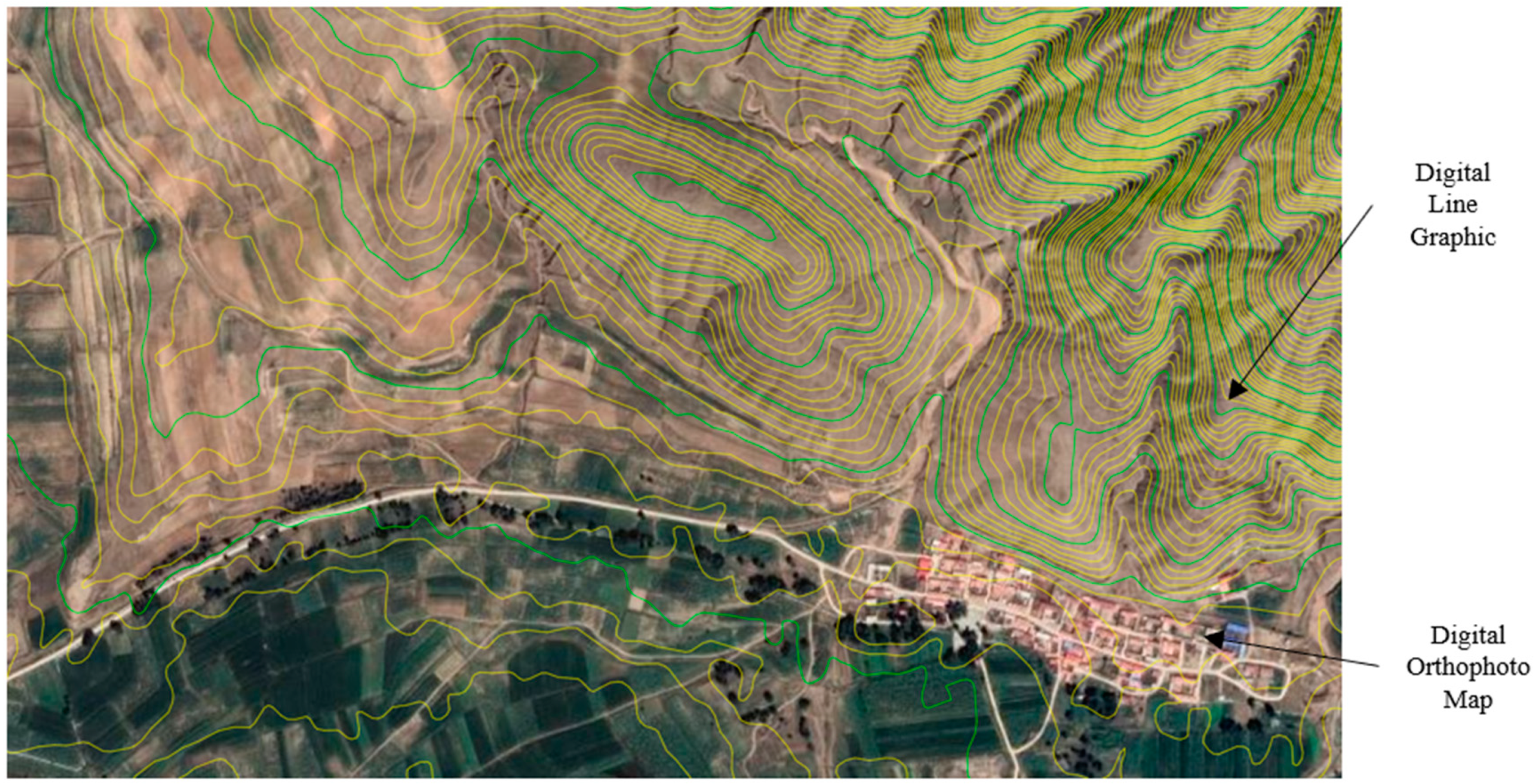
aerial survey work of the wind farm once by using the aerial survey technology. The effect diagram of the digital elevation model generated by this technology is shown in Figure 1.
Figure 1.Effect diagram of digital elevation model.
Effect diagram of digital elevation model.

Jie Zhang [2] proposed the generation of a digital wind farm corridor by unmanned aerial vehicle (UAV) on-board radar. By introducing the practical application of LiDAR technology in the Hunan Dama wind farm project, the feasibility of the application of LiDAR technology in the wind farm project is explained. The workflow is shown in Figure 2.

Figure 2.
LiDAR workflow
[2]
.

2.2. Professional software aided design

2.2. Professional Software-Aided Design

Mohamed El Masry et al. [3] used the STROBOSCOPE simulation tool to simulate the construction process of the wind farm. The simulation result of the tool can calculate the excavation and filling quantity generated according to different routes when the approach road is constructed, which significantly reduces the construction cost and time. Feng-yu Ma [4] and others attached the design results to the Google Earth satellite image (Figure 3) and corrected the position of the road path on the digital topographic map according to the actual natural terrain, thus improving the design quality. Jian Xiao et al. [5] used BIM and topographic information systems to carry out three-dimensional modeling of the proposed site and buildings and realized automatic route selection and collection line planning and design based on three-dimensional real-world modeling of unmanned aerial vehicles. Ke-ren Chen [6] and others integrated GIS with BIM for the first time, applied a three-dimensional design mode to wind power design, developed a three-dimensional digital design platform for wind farms, assisted professional designers to design synchronously, and guided field installation and construction of equipment by a three-dimensional digital model, which improved the precision of project construction.
Figure 3.
Path design on a digital topographic map.

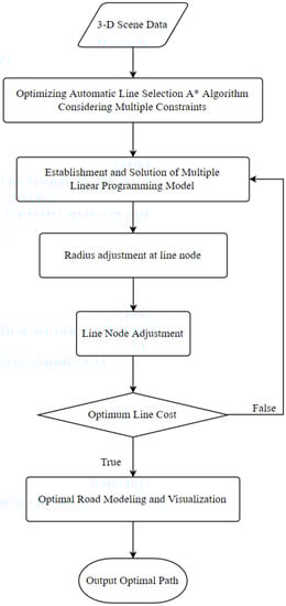
2.3. Intelligent Road Routing Model

Shi-qing Zeng et al. [7] established a road centerline planning network model considering the multi-dimensional and complex terrain environment of wind farms in order to meet the demand for intelligent road design for the safe transportation of fan equipment. Based on the traditional GIS routing algorithm, they proposed a method for road optimization design of wind farms with multi-dimensional terrain and fan parameter constraints. The algorithm flow of this method is shown in Figure 4. It breaks through the limitation of traditional road design, mainly relying on CAD-aided mapping technology in the overall expression of multi-dimensional space and realizes the complete expression of three-dimensional real-world information of wind farm roads.
Figure 4.
Algorithm flow.
Tao Zhou [8] and others utilized the method of road optimization design based on the multiple linear programming (LP) model. The model’s algorithm flow is shown in Figure 5, which realizes the rapid construction of planar roads taking into account the construction cost of wind power projects and the road alignment design specifications in the three-dimensional GIS environment, and finally obtains the route design scheme with the best construction cost and standardized revision.
Figure 5.
LP model's algorithm flow.
Yue-shuang Wang [9] and others used GIS to collect, store, manage, and analyze geospatial information. Based on the intelligent route selection model of mountain wind farm road based on the improved A* algorithm (Figure 6), the road route selection was optimized according to the characteristics of mountainous areas. Finally, the intelligent route selection was realized through GIS by Python programming.
Figure 6.
Flow chart of an improved A* algorithm.
M. Kotb et al. [10] proposed an optimal approach road route solution formula based on genetic algorithm (GA) technology for precise and fast planning of the construction process. An illustrative example was implemented in M ATLAB to verify the applicability of this formula and reduce time costs. Long-fei Wang et al. [11] established the extended network structure of wind power units based on vehicle-mounted GPS data and combined it with wind power operation and maintenance business scenarios using the SOM clustering method, and then used the Dijkstra algorithm to find the optimal path between units, solving the road planning problem between units in operation and maintenance of the wind farm and reducing the operation and maintenance costs. The logic of the algorithm is shown in Figure 7.
Figure 7.
GA algorithm logic
[10]
.
Kui-bin Yang [12] and other wind farm layout optimization problems based on the Jensen wake model are modeled as objective functions and constraints. Considering the influence of the wake superposition area, they are solved by the genetic algorithm and mathematical programming method. A joint automatic optimization method for road position in the wind farm field based on a software algorithm is proposed.
Aerial surveying equipment and professional software aids improve the design only by improving the accuracy of topographic maps and reducing field operations. However, the establishment of the intelligent road route selection model can consider the local geographical environment, road level, vertical and horizontal combination, design specifications, and other aspects of comprehensive route selection. Therefore, the intelligent road route selection model is more suitable for road route selection than the two methods mentioned above.

3. Problems in Road Design of Wind Farms

3.1. Unclear Constraints of Intelligent Line Selection Models

The function of the intelligent route selection model is to organically integrate the abstract and difficult-to-understand spatial information and solve the optimal route of the road by using the A* algorithm, genetic algorithm, Dijkstra algorithm, and other technologies, and taking the interference factors existing in the process of route selection as constraints. At present, the researcher holds their own views on the selection of constraints for the intelligent route selection model in China. Shi-qing Zeng [7] and others have designed an intelligent route selection model based on the constraints of distance, slope, and the amount of filling and excavation. Tao Zhou [8] waits to reconsider the road alignment design specifications and the influence of road transportation safety on route selection. Yue-shuang Wang [9] takes the longitudinal slope gradient, the length of the longitudinal slope, the vertical curve corner, and the allowable passing area of prohibited obstacles as the constraints. M. Kotb [10] and Long-fei Wang [11] pay more attention to the impact of time cost on road routing. The constraints selected by Kui-bin Yang [12] are time cost, unoccupied area, and area of wake superposition area. It can be seen that the research experts in the field of intelligent route selection of wind power roads in China have not yet formed a unified and clearly defined model of interference factors.

3.2. The Variety of Design Vehicles Used in Circular Curve Design Index Research Is Relatively Single

In road geometry design, the characteristics of vehicle profile size, weight, and running characteristics are used as the basis of road geometry design and play a decisive role in road geometry design. There are many kinds of wind power equipment transporting vehicles. At present, flat-blade transporting semi-trailers, low-flat semi-trailers, wind-blade lifting vehicles, and rear wheel steering transporters are mainly used. As the outline dimensions of different types of vehicles vary greatly, the requirements for road design parameters are also very different. In the research field of circular curve design index, Yong-hong Yang [13] selected a vane flat semi-trailer and a rear wheel steering vehicle as design vehicles. Ying-fu Guo [14] selected the vane lift vehicle as the design vehicle. Xin-liang Yao [15], Kang-dong Chen [16], Jian-wen Du [17], Mei-xuan Ji [18], Yi-ming Zhao [19], La-chun Ren [20], and other scholars designed vehicles with a bladed flat semi-trailer. It can be seen that the vehicles used in this field are relatively single, and there is no research on the influence of special vehicles on road design indicators.

3.3. The Incomplete Forecasting Model of Soil and Water Loss Intensity

Soil and water losses in wind farms are closely related to environmental conditions. Local meteorological, vegetation, and topographic factors of wind farms have different effects on water and soil losses in wind farms. Currently, the research on water and soil loss prediction mainly predicts the intensity of wind farm water and soil loss from one of the three impacts as a key parameter. In terms of meteorological factors, Wang Wan-zhong [21],[22] analyzed the spatiotemporal variation characteristics of water and sediment in relevant regions with hydrological data analysis. Zhi-lin Huang [23] analyzed the difference in water and soil losses in different slope gradients, land use patterns, and precipitation changes using precipitation data. In terms of vegetation factors, Linda Cyr et al. [24], Sanjay K. Jain et al. [25], Hong-ping Zhong [26], Jin-ding Guo, etc., [27] used the NDVI index as the vegetation factor index. In terms of topographic factors, Xin-hua Liu et al. [28] proposed an alternative index based on the theory of erosion geomorphology. Therefore, in the field of forecasting soil and water loss intensity, the existing forecasting model of soil and water loss intensity is not perfect, and there is no model of soil and water loss considering the influence of comprehensive factors.

References

  1. Liu, W.; Zhu, R. Application of UAV aerial photogrammetry technology in wind farm survey and design. Inn. Mong. Power Technol. 2013, 31, 75–79. (In Chinese)
  2. Zhang, J. Research on the Application of UAV LiDAR in Road Survey and Design of Wind Farm. Wind. Energy 2019, 03, 66–71.(In Chinese)
  3. El Masry, M.; Nassar, K.; Osman, H. Simulating the Effect of Access Road Route Selection on Wind Farm Construction.Comput. Civ. Eng. 2011.
  4. Ma, F.; Li, K.; Meng, X. Research on the Application of Satellite Images and Digital Topographic Maps in Wind Power Plants. Wind. Energy 2014, 03, 66–69. (In Chinese)
  5. Xiao, J.; Cong, O.; Hao, H.; Wang, H. Development and application of BIM technology in wind farm construction. Life Sci. J.2018, 02, 56–59. (In Chinese)
  6. Chen, K.; Wang, Y. Research on 3D Digital Design System of Wind Farm Based on GIS + BIM. Energy Technol. 2021, 19, 50–53.(In Chinese)
  7. Zeng, S.; Xie, X.; Zhang, Y.; Zeng, H.; Zhu, Q.; Cao, Z. Multi Dimensional Terrain Environment and Fan Parameter Constraint Wind Farm Road Optimal Design Method. Geogr. Inf. World 2018, 25, 54–59. (In Chinese)
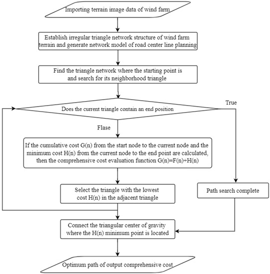
  8. Zhou, T.; Zhu, Q.; Zeng, H.; Xie, X.; Ding, Y.L. Wind Farm Road Optimization Design Method Based on Multiple Linear Programming Model. Geogr. Inf. World 2019, 26, 61–65. (In Chinese)
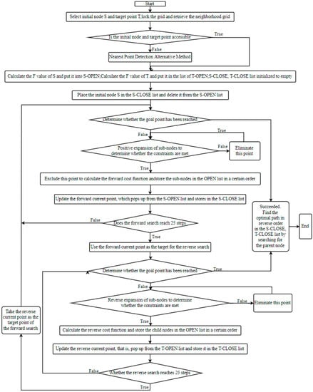
  9. Wang, Y. Intelligent Route Selection Method of Wind Farm Road in the Mountain Based on Improved A* Algorithm. Master’s Thesis, Shijiazhuang Railway University, Shijiazhuang, China, 2021. (In Chinese)
  10. Kotb, M.; Elhelloty, A.; Shaaban, M. Selecting Optimal Access Roads for Mobile Crane in Wind Farm Project. Life Sci. J. 2019, 16,28–31.
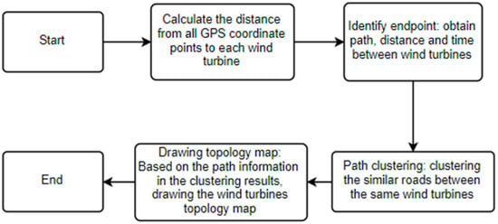
  11. Wang, L.; Liu, J. Route Optimization of Wind Turbines Based On Vehicle Gps Data. In 2020 Global Reliability and Prognostics and Health Management (PHM-Shanghai); IEEE: New York, NY, USA, 2020
  12. Yang, K.; Du, H.; Wang, Q.; Liu, P. Research and Application of Optimal Road Design Algorithm for Wind Farm. Distrib. Energy 2022, 7, 56–62. (In Chinese)
  13. Yang, Y.; Chen, Z.; Wang, X.; Mao, G. Study of Highway Horizontal Curve Radius for Large Air Blower Transportation in Wind Farm. Highw. Eng. 2014, 39, 73–75. (In Chinese)
  14. Guo, Y.; Liu, Y.; Liu, H.; Xu, H.; Tang, W. Analysis on Turning Radius and Road Occupation of Mountain Transport Vehicles withFan Blades. Highw. Automob. Transp. 2013, 04, 11–14. (In Chinese)
  15. Yao, X. Research on Road Design of Wind Farm. Master’s Thesis, Zhejiang University, Hangzhou, China, 2013. (In Chinese).
  16. Chen, K.; Li, X. Road Route Design and Key Points Analysis of Wind Farm in Hilly Areas. Sol. Energy 2013, 24, 57–60. (In Chinese)
  17. Du, J.; Qi, J. Design of Widening the Turning Radius of Wind Farm Roads. Low Carbon World 2014, 23, 57–60. (In Chinese)
  18. Ji, M. Selection of road parameters and paths for wind farms. Wind. Energy 2016, 03, 52–54. (In Chinese)
  19. Zhao, Y. Study on Design Index of Circle Curve Radius and Pavement Width in Mountain Wind Farm. Highw. Eng. 2018, 43,124–128. (In Chinese)
  20. Ren, L.; Xu, N.; Chai, L. Application of AutoTURN in Road Design of Southwest Mountain Wind Farm. Hydropower Stn. Des.2019, 35, 23–25. (In Chinese)
  21. Wang, W.; Jiao, J.; Ma, L. Changes in erosion and sand production intensity in different erosion types of the Loess Plateau and their management objectives. Soil Water Conserv. Bull. 2012, 32, 1–7. (In Chinese)
  22. Wang, W.; Jiao, J. Temporal and Spatial Variation Features of Sediment Yield Intensity on Loess Plateau. Acta Geogr. Sin. 2002, 57,210–217. (In Chinese)
  23. Hang, Z.; Bo, B.; Chen, L. Soil and Water Loss Differentiation of Different Slopes, Land Use Types and Precipitation Changes in Loess Hilly Area. Sci. Soil Water Conserv. 2005, 3, 11–18. (In Chinese)
  24. Cyr, L.; Ferdinand, B.; Alain, P. Vegetation indices derived from remote sensing for an estimation of soil protection against water erosion. Ecol. Model. 1995, 79, 277–285.
  25. Jain, S.K.; Goel, M.K. Assessing the vulnerability to soil erosion of the Ukai Dam catchments using remote sensing and GIS.Int. Assoc. Sci. Hydrol. 2002, 47, 31–40.
  26. Zhong, H.; Wang, H. Analysis on Spatio-temporal Change Characteristics of Normalized Vegetation Index in Hubei Province from 2007 to 2016. J. Cent. China Norm. Univ. (Nat. Sci.) 2018, 52, 582–588. (In Chinese)
  27. Guo, J.; Hu, Y.; Xiong, Z. Spatio-temporal changes of NDVI during vegetation growth season in permafrost region of Northeast China and its response to climate change. Chin. J. Appl. Ecol. 2017, 28, 2413–2422. (In Chinese)
  28. Liu, X.; Yang, Q.; Tang, G. Extraction and Application of Relief of China Based on DEM and GIS Method. Bull. Soil Water Conserv. 2001, 21, 57–62. (In Chinese)
More
ScholarVision Creations