风电在新能源时代发展中发挥着重要作用,风电场道路也是风电设施建设的早期准备。风电场地形条件复杂,风电机组设备重量大、体积长、道路运输经济性要求高、相关标准规范缺失等,导致风电场道路设计和路线选择困难。此外,风电场建设中频繁的开挖和填埋,严重破坏了原地表植被覆盖和土壤结构,造成大量水土流失和风电场生态破坏。Wind power plays an important role in the development of new energy era, and the road of wind farm is also the early preparation for the construction of wind power facilities. The complex terrain conditions of wind farm, large weight, long volume of wind turbine equipment, high economic requirement of road transportation, and lack of relevant standards and specifications lead to difficulty in road design and route selection of wind farm. In addition, frequent excavation and landfills during the construction of wind farm seriously destroy the original surface vegetation cover and soil structure, resulting in a large number of water and soil losses and ecological damage of wind farm.
1.brief 简介introduction
With the increasing demand for energy conservation and emission reduction and the reduction of power generation costs from renewable energy sources, the global wind energy and other new energy power generation industries are developing rapidly. In terms of wind power, according to the data of the Global Wind Energy Association, the total installed capacity of wind power in the world was 837 GW by the end of 2021, with China ranking first with 338.31 GW. According to the data of the State Energy Administration, the accumulated installed capacity of wind power in China reached 5.2021 GW in 328, accounting for 13.8% of the total installed capacity of domestic power generation, next only to hydropower and thermal power. Wind power is a green energy source. Compared with other new energy generation technologies, wind power has the advantages of short construction period, mature technology, high reliability and low cost, and has a very broad development prospect.
随着节能减排需求的日益增加和可再生能源发电成本的降低,全球风能等新能源发电产业发展迅速。风力发电方面,根据全球风能协会的数据,截至2021年底,全球风电总装机容量为837吉瓦,其中中国以338Domestic and foreign scholars have carried out relevant research on the construction of wind farms and concluded that the difficulty of road construction in mountainous wind farms directly affects the cost of wind farm construction.31吉瓦排名第一。根据国家能源局的数据,328年我国风电累计装机容量达到5.2021吉瓦,占国内发电总装机容量的13.8%,仅次于水电和火电。风力发电是绿色能源。与其他新能源发电技术相比,风电具有建设周期短、技术成熟、可靠性高、成本低等优点,具有非常广阔的发展前景。
国内外学者对风电场建设进行了相关研究,得出的结论是,山区风电场道路建设的难度直接影响到风电场建设的成本。山区风电场的道路建设仅占风电场投资成本的一小部分,一般在10%左右。但是,它占土木工程建设成本的 Road construction of mountain wind farms only accounts for a small part of the investment cost of wind farms, generally about 10%. However, it accounts for more than 50%以上,是工程成本控制中非常重要的一部分。另一方面,随着近年来风电项目的规模化开发,对风电建设非常有利的地形资源日益紧张。陆上风电场类型在丘陵、山区等风资源较好、风电项目建设相对投资大幅增加的地区推进。在风力电厂建设期间的设备运输过程中,风电机组的塔架、叶片、机舱、轮毂、变压器均为重件,对风电道路有特殊要求,使道路设计困难。因此,系统研究风电场的道路非常重要。 of the construction cost of civil engineering and is a very important part of the project cost control. On the other hand, with the large-scale development of wind power projects in recent years, terrain resources which are very beneficial to wind power construction are becoming increasingly scarce. The type of onshore wind farm is promoted in areas with good wind resources such as hills and mountainous areas and a large increase in relative investment in wind power project construction. During the equipment transportation during the construction of wind power plant, the tower, blade, engine room, wheel hub and transformer of wind power unit are all heavy parts, which have special requirements for wind power road, making road design difficult. Therefore, it is very important to systematically study the path of wind farms.
2. 择线方法优化研究Resarch on Line Selection Method Optimization
传统的路线选择分为纸质路线确定和野外调查路线选择。室内路线选择是在小比例尺地形图上进行的。根据收集到的数据,经过对比分析后确定几种较好的方案,经过实地调查最终确定最佳路线。地形图受到比例尺小、现状差等缺点的限制,地形特征与实际情况有很大不同。为了解决这个问题,许多学者对路线选择方法进行了改进和优化,可分为机载测量设备辅助测量、专业软件辅助设计和智能道路路线选择模型三种类型。
Traditional route selection is divided into paper route determination and field survey route selection. Indoor route selection is carried out on small-scale topographic map. According to collected data, several better schemes are determined after comparative analysis, and the best route is finally determined after field survey. The topographic map is restricted by such disadvantages as small scale and poor current situation, and the topographic features are quite different from the actual situation. To solve this problem, many scholars have improved and optimized the route selection method, which can be divided into three types: airborne surveying equipment auxiliary survey, professional software auxiliary design and road intelligent route selection model.
2.1.Auxiliary 航空测量设备的辅助测量Survey of Aerial Surveying Equipment
风电场地形勘察是整个道路设计阶段的重要环节。地形测量的准确性间接影响道路工程的整体成本和风电场的建设难度。风电道路设计的传统方式是设计者使用测量设备进行现场勘测,但是外部测绘的工作是否繁重,一些特殊的地形不能精确测量吗?为了提高电力勘测设计的质量和勘察设计进度,航空勘测技术作为一种勘测手段,在电力行业勘察设计中得到了广泛的应用。The wind farm topographic survey is an important link in the whole road design stage. The accuracy of the topographic survey indirectly affects the overall cost of road engineering and the construction difficulty of wind farms. The traditional way of wind power road design is that the designer uses measuring equipment to carry out the on-site survey, but is the work of external mapping heavy and can some special terrain not be precisely measured? In order to improve the quality of the electric power survey and design and the progress of the survey and design, aviation survey technology, as a survey means, has been widely used in the electric power industry survey and design.
Wei Liu [1] and others combined the application example of unmanned aerial vehicle
(UAV) aerial survey technology in a wind farm in Inner Mongolia and completed the
aerial survey work of the wind farm once by using the aerial survey technology. The effect diagram of the digital elevation model generated by this technology is shown in Figure 1.
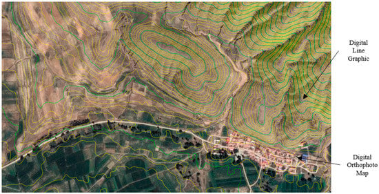
刘伟[1]等人结合无人机航测技术在内蒙古某风电场的应用实例,利用航测技术一次性完成了风电场的航测工作。该技术生成的数字高程模型的效果图如图1所示。
图Figure 1.数字高程模型效果图.Effect diagram of digital elevation model.
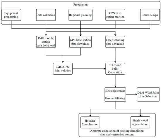
张杰[2]提出利用无人机(UAV)车载雷达生成数字风电场走廊。通过介绍激光雷达技术在湖南达玛风电场项目中的实际应用,阐述了激光雷达技术在风电场项目中应用的可行性。工作流如图 2 所示。 Jie Zhang [2] proposed the generation of a digital wind farm corridor by unmanned aerial vehicle (UAV) on-board radar. By introducing the practical application of LiDAR technology in the Hunan Dama wind farm project, the feasibility of the application of LiDAR technology in the wind farm project is explained. The workflow is shown in Figure 2.
图Figure 2.激光雷达工作流程 LiDAR [2]。workflow[2].
2.2. Professional 专业软件辅助设计software aided design
Mohamed El Masry
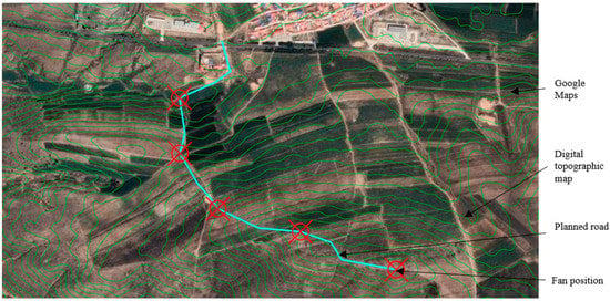
等人[3]使用频闪仪模拟工具来模拟风电场的建设过程。该工具的仿真结果可以计算出进场道路施工时根据不同路线产生的开挖和充填量,大大降低了施工成本和时间。马凤玉[4]等人将设计结果附在谷歌地球卫星图像(图 et al. [3] used the STROBOSCOPE simulation tool to simulate the construction process of the wind farm. The simulation result of the tool can calculate the excavation and filling quantity generated according to different routes when the approach road is constructed, which significantly reduces the construction cost and time. Feng-yu Ma [4] and others attached the design results to the Google Earth satellite image (Figure 3
)上,并根据实际自然地形校正了数字地形图上道路路径的位置,从而提高了设计质量。肖健等[5]利用) and corrected the position of the road path on the digital topographic map according to the actual natural terrain, thus improving the design quality. Jian Xiao et al. [5] used BIM
和地形信息系统对拟建场地和建筑物进行三维建模,实现基于无人机三维实景建模的自动路线选择和收集线规划设计。陈克仁[6]等首次将 and topographic information systems to carry out three-dimensional modeling of the proposed site and buildings and realized automatic route selection and collection line planning and design based on three-dimensional real-world modeling of unmanned aerial vehicles. Ke-ren Chen [6] and others integrated GIS
与 with BIM
集成,将三维设计模式应用于风电设计,开发风电场三维数字化设计平台,辅助专业设计人员同步设计,以三维数字模型指导现场安装施工设备,提高了工程施工精度。 for the first time, applied a three-dimensional design mode to wind power design, developed a three-dimensional digital design platform for wind farms, assisted professional designers to design synchronously, and guided field installation and construction of equipment by a three-dimensional digital model, which improved the precision of project construction.
图Figure 3.数字地形图上的路径设计。 Path design on a digital topographic map.
2.3. 智能道路路径模型Intelligent Road Routing Model
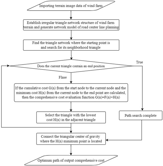
曾世清等[7]建立了考虑风电场多维复杂地形环境的道路中心线规划网络模型,以满足风机设备安全运输对智能道路设计的需求。基于传统的Shi-qing Zeng et al. [7] established a road centerline planning network model considering the multi-dimensional and complex terrain environment of wind farms in order to meet the demand for intelligent road design for the safe transportation of fan equipment. Based on the traditional GIS
路径算法,提出了一种多维地形和风机参数约束的风电场道路优化设计方法。该方法的算法流程如图 routing algorithm, they proposed a method for road optimization design of wind farms with multi-dimensional terrain and fan parameter constraints. The algorithm flow of this method is shown in Figure 4. It breaks through the limitation of traditional road design, mainly relying 4on 所示。突破传统道路设计的局限,在多维空间的整体表达中主要依靠CAD
辅助测绘技术,实现风电场道路三维真实世界信息的完整表达。-aided mapping technology in the overall expression of multi-dimensional space and realizes the complete expression of three-dimensional real-world information of wind farm roads.
图Figure 4.算法流。 Algorithm flow.
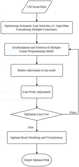
周涛[8]等人利用了基于多重线性规划(Tao Zhou [8] and others utilized the method of road optimization design based on the multiple linear programming (LP
)模型的道路优化设计方法。模型的算法流程如图5所示,在三维) model. The model’s algorithm flow is shown in Figure 5, which realizes the rapid construction of planar roads taking into account the construction cost of wind power projects and the road alignment design specifications in the three-dimensional GIS
环境下,在考虑风电项目建设成本和道路路线设计规范的情况下,实现了平面道路的快速建设,最终得到施工成本最优、标准化修订的路线设计方案。 environment, and finally obtains the route design scheme with the best construction cost and standardized revision.
图Figure 5. LP 模型的算法流。model's algorithm flow.
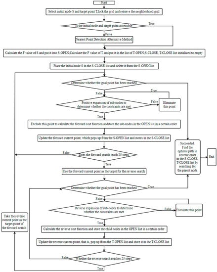
Yue-shuang Wang
[9] and others used GIS to collect, store, manage, and analyze geospatial information. Based on the intelligent route selection model of mountain wind farm road based on the improved A* algorithm (
Figure 6), the road route selection was optimized according to the characteristics of mountainous areas. Finally, the intelligent route selection was realized through GIS by Python programming.
Figure 6. Flow chart of an improved A* algorithm.
M. Kotb et al.
[10] proposed an optimal approach road route solution formula based on genetic algorithm (GA) technology for precise and fast planning of the construction process. An illustrative example was implemented in M ATLAB to verify the applicability of this formula and reduce time costs. Long-fei Wang et al.
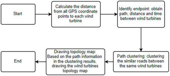
[11] established the extended network structure of wind power units based on vehicle-mounted GPS data and combined it with wind power operation and maintenance business scenarios using the SOM clustering method, and then used the Dijkstra algorithm to find the optimal path between units, solving the road planning problem between units in operation and maintenance of the wind farm and reducing the operation and maintenance costs. The logic of the algorithm is shown in
Figure 7.Figure 7.
图7. GA
算法逻辑algorithm logic [10]。[10].
将杨奎斌[12]和其他基于詹森尾流模型的风电场布局优化问题建模为目标函数和约束。考虑尾流叠加区的影响,采用遗传算法和数学规划方法求解。提出了一种基于软件算法的风电场场道路位置联合自动优化方法。Kui-bin Yang [12] and other wind farm layout optimization problems based on the Jensen wake model are modeled as objective functions and constraints. Considering the influence of the wake superposition area, they are solved by the genetic algorithm and mathematical programming method. A joint automatic optimization method for road position in the wind farm field based on a software algorithm is proposed.
航空测量设备和专业软件辅助工具只能通过提高地形图的准确性和减少野外作业来改进设计。但是,智能道路路线选择模型的建立可以考虑当地的地理环境,道路水平,纵横组合,设计规范以及综合路线选择等方面。因此,智能道路路线选择模型比上述两种方法更适合道路路线选择。Aerial surveying equipment and professional software aids improve the design only by improving the accuracy of topographic maps and reducing field operations. However, the establishment of the intelligent road route selection model can consider the local geographical environment, road level, vertical and horizontal combination, design specifications, and other aspects of comprehensive route selection. Therefore, the intelligent road route selection model is more suitable for road route selection than the two methods mentioned above.
三、风电场道路设计存在的问题3. Problems in Road Design of Wind Farms
3.1. 智能选线模型的不明确约束Unclear Constraints of Intelligent Line Selection Models
智能选路模型的作用是利用The function of the intelligent route selection model is to organically integrate the abstract and difficult-to-understand spatial information and solve the optimal route of the road by using the A*
算法、遗传算法、 algorithm, genetic algorithm, Dijkstr
a算法等技术,以选路过程中存在的干扰因素为约束,将抽象的、难以理解的空间信息有机地整合,求解道路的最优路线。目前,研究者对我国智能路线选择模型的约束选择持有自己的看法。曾世清[7]等人基于距离、坡度、填挖量等约束,设计了智能选路模型。周涛[8]等待重新考虑道路路线设计规范以及道路运输安全对路线选择的影响。王岳双[9]以纵向坡度、纵向坡度长度、垂直曲线拐角、禁止障碍物允许通过面积为约束条件。a algorithm, and other technologies, and taking the interference factors existing in the process of route selection as constraints. At present, the researcher holds their own views on the selection of constraints for the intelligent route selection model in China. Shi-qing Zeng [7] and others have designed an intelligent route selection model based on the constraints of distance, slope, and the amount of filling and excavation. Tao Zhou [8] waits to reconsider the road alignment design specifications and the influence of road transportation safety on route selection. Yue-shuang Wang [9] takes the longitudinal slope gradient, the length of the longitudinal slope, the vertical curve corner, and the allowable passing area of prohibited obstacles as the constraints. M. Kotb
[10] 和and Long-fei Wang
[11] pay more attention to the impact [11]of time cost on road routing. The constraints selected by Kui-bin Yang [12] are time cost, unoccupied area, and area of wake superposition area. It can be seen that the research experts in the field of intelligent route selection of wind power roads in China have not yet formed a unified and clearly defined model of interference 更关注时间成本对道路路线的影响。杨奎斌[12]选择的约束条件是时间成本、未占用面积和尾流叠加面积。由此可见,我国风电道路智能选路领域的研究专家尚未形成统一明确的干扰因素模型。factors.
3.2. 圆曲线设计指标研究中使用的设计车辆种类相对单一The Variety of Design Vehicles Used in Circular Curve Design Index Research Is Relatively Single
在道路几何设计中,车辆轮廓尺寸、重量和运行特性等特征作为道路几何设计的基础,在道路几何设计中起着决定性的作用。风电设备运输车辆种类繁多。目前主要采用平叶运输半挂车、低平半挂车、风力叶片起重车、后轮转向运输车。由于不同类型车辆的外形尺寸差异很大,因此对道路设计参数的要求也有很大差异。在圆曲线设计指标研究领域,杨永红[17]选用叶片扁平半挂车和后轮转向车作为设计车辆。郭英福[13]选择了叶片升降车作为设计车。姚新良[14]、陈康东[15]、杜建文[16]、纪美轩[18]、赵一明[20]、任拉春[22]等学者设计了带叶片平板半挂车的车辆。由此可见,该领域使用的车辆比较单一,目前还没有关于特种车辆对道路设计指标影响的研究。In road geometry design, the characteristics of vehicle profile size, weight, and running characteristics are used as the basis of road geometry design and play a decisive role in road geometry design. There are many kinds of wind power equipment transporting vehicles. At present, flat-blade transporting semi-trailers, low-flat semi-trailers, wind-blade lifting vehicles, and rear wheel steering transporters are mainly used. As the outline dimensions of different types of vehicles vary greatly, the requirements for road design parameters are also very different. In the research field of circular curve design index, Yong-hong Yang [13] selected a vane flat semi-trailer and a rear wheel steering vehicle as design vehicles. Ying-fu Guo [14] selected the vane lift vehicle as the design vehicle. Xin-liang Yao [15], Kang-dong Chen [16], Jian-wen Du [17], Mei-xuan Ji [18], Yi-ming Zhao [19], La-chun Ren [20], and other scholars designed vehicles with a bladed flat semi-trailer. It can be seen that the vehicles used in this field are relatively single, and there is no research on the influence of special vehicles on road design indicators.
3.3. The 水土流失强度的不完全预测模型Incomplete Forecasting Model of Soil and Water Loss Intensity
风电场的土壤和水损失与环境条件密切相关。风电场局部气象、植被、地形因子对风电场水土流失的影响不同。目前,水土流失预测研究主要以预测风电场水土流失强度为关键参数,从三种影响之一。在气象因子方面,王万忠[66,67]通过水文数据分析分析了相关区域水和沉积物的时空变化特征。黄志林[68]利用降水资料分析了不同坡度、土地利用模式和降水变化下水土流失的差异。在植被因子方面,Soil and water losses in wind farms are closely related to environmental conditions. Local meteorological, vegetation, and topographic factors of wind farms have different effects on water and soil losses in wind farms. Currently, the research on water and soil loss prediction mainly predicts the intensity of wind farm water and soil loss from one of the three impacts as a key parameter. In terms of meteorological factors, Wang Wan-zhong [21],[22] analyzed the spatiotemporal variation characteristics of water and sediment in relevant regions with hydrological data analysis. Zhi-lin Huang [23] analyzed the difference in water and soil losses in different slope gradients, land use patterns, and precipitation changes using precipitation data. In terms of vegetation factors, Linda Cyr
等[69], et al. [24], Sanjay K. Jain
等[70],钟红平[71],郭金鼎等[72]使用 et al. [25], Hong-ping Zhong [26], Jin-ding Guo, etc., [27] used the NDVI
指数作为植被因子指数。在地形因素方面,刘新华等[73]提出了基于侵蚀地貌理论的替代指标。因此,在水土流失强度预测领域,现有的水土流失强度预测模型并不完善,不存在考虑综合因素影响的土流失模型。 index as the vegetation factor index. In terms of topographic factors, Xin-hua Liu et al. [28] proposed an alternative index based on the theory of erosion geomorphology. Therefore, in the field of forecasting soil and water loss intensity, the existing forecasting model of soil and water loss intensity is not perfect, and there is no model of soil and water loss considering the influence of comprehensive factors.