Your browser does not fully support modern features. Please upgrade for a smoother experience.
Please note this is a comparison between Version 2 by Catherine Yang and Version 1 by Xiuquan Hu.
The requirements for the accurate characterization of shoal sediments have increased in view of the fact that strata are eroded due to uplift and it is difficult to calculate the real thickness of granular shoal. To solve this problem, with the shoal-to-strata ratio, the type and distribution range of carbonate rock shoal facies are described, and the characterization of sedimentary facies is subsequently presented.
- shoal-to-strata ratio
- carbonate rock shoal facies
- Eastern Sichuan area
1. Introduction
As development and research related to the oil and gas sector continuously increase, it is necessary to carry out sedimentary facies analysis to identify favorable reservoir facies belts. The study of sedimentary facies and sub-facies, especially microfacies, is vital for the development of subtle oil and gas reservoirs [1,2][1][2]. In recent years, it has been found that a large amount of oil and gas is stored in the reservoirs of shoal facies [3[3][4][5],4,5], indicating that favorable shoal facies are important for the formation of oil and gas reservoirs [3,6,7,8,9,10,11,12,13][3][6][7][8][9][10][11][12][13]. An important factor restricting the progress of oil and gas exploration is the poor understanding of the distribution regularity of shoal facies [14,15][14][15]. Many researchers have conducted extensive research on shoals, including the study of sedimentary environments [16], controlling factors [17[17][18],18], and types and depositional patterns of shoals [19]. The results from previous studies have shown that shoal facies can be formed in sedimentary environments of carbonate platforms, platform edges, gentle slopes, and tidal flats [16,20,21,22][16][20][21][22]. The quality of carbonate shoal facies reservoirs is controlled by sedimentary microfacies and micro-paleo-geomorphic fluctuations.
2. Geological Background
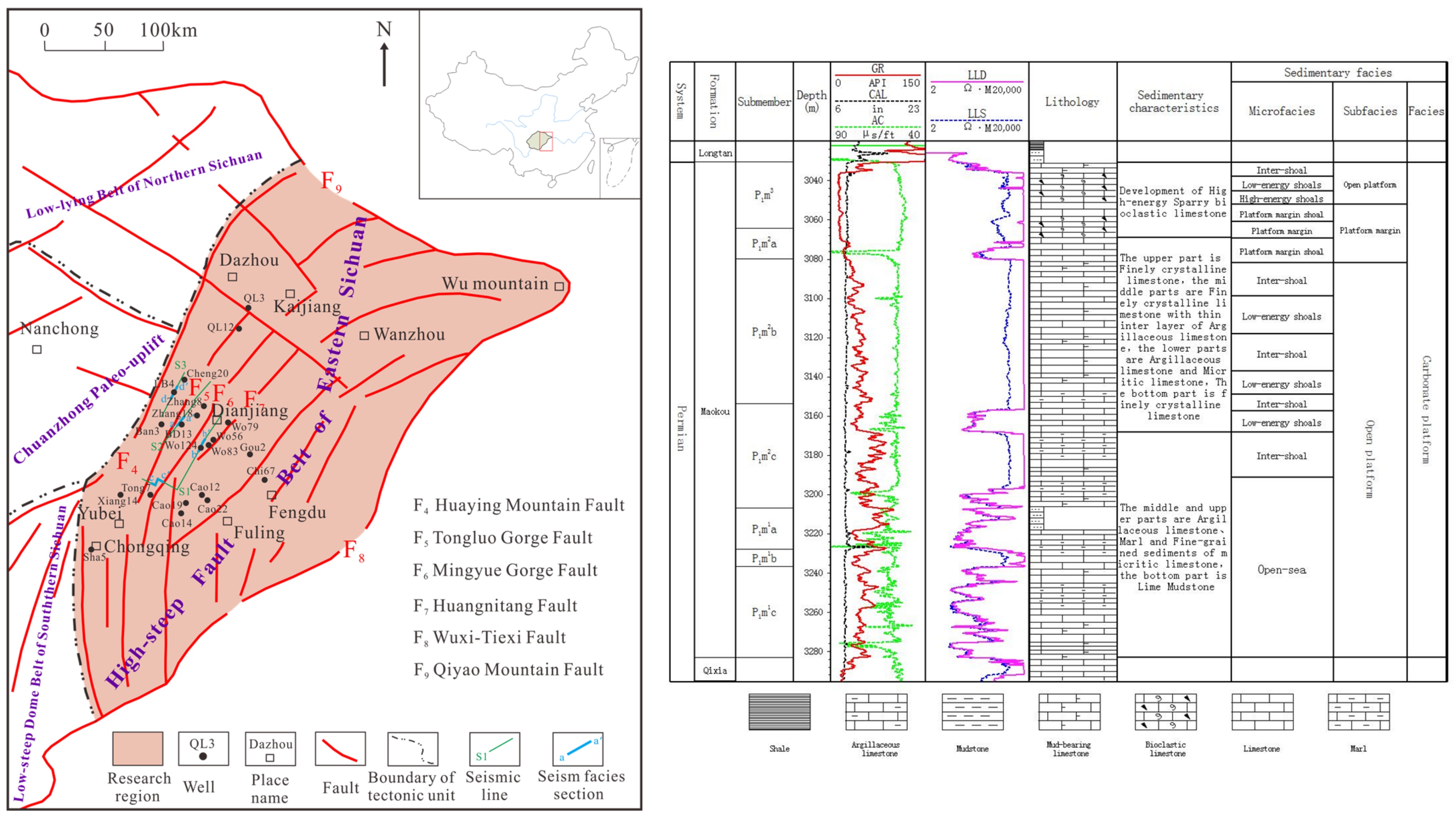
The Eastern Sichuan region is under the jurisdiction of the Chongqing–Fuling Line and includes counties such as Kaijiang, Wanzhou, Dazhu, Dianjiang, Fengdu, Yubei, and Fuling in Chongqing (Figure 1). It is located in the southern Sichuan Basin, among Mounts Huaying, Qiyao, and Daba. There are numerous ejective folds trending northeast–southwest in Eastern Sichuan from west to east. This abnormally developed fault belt includes Tongluo Gorge, Mingyue Gorge, and Huangnitang [25,27,28,29][23][24][25][26].
Figure 1.
Geographical location map of study area showing relevant fault lines and wells (modified from [21]), and comprehensive histogram of Well Ban3.
3. The Technical Workflow for the Method of the Shoal-to-Strata Ratio
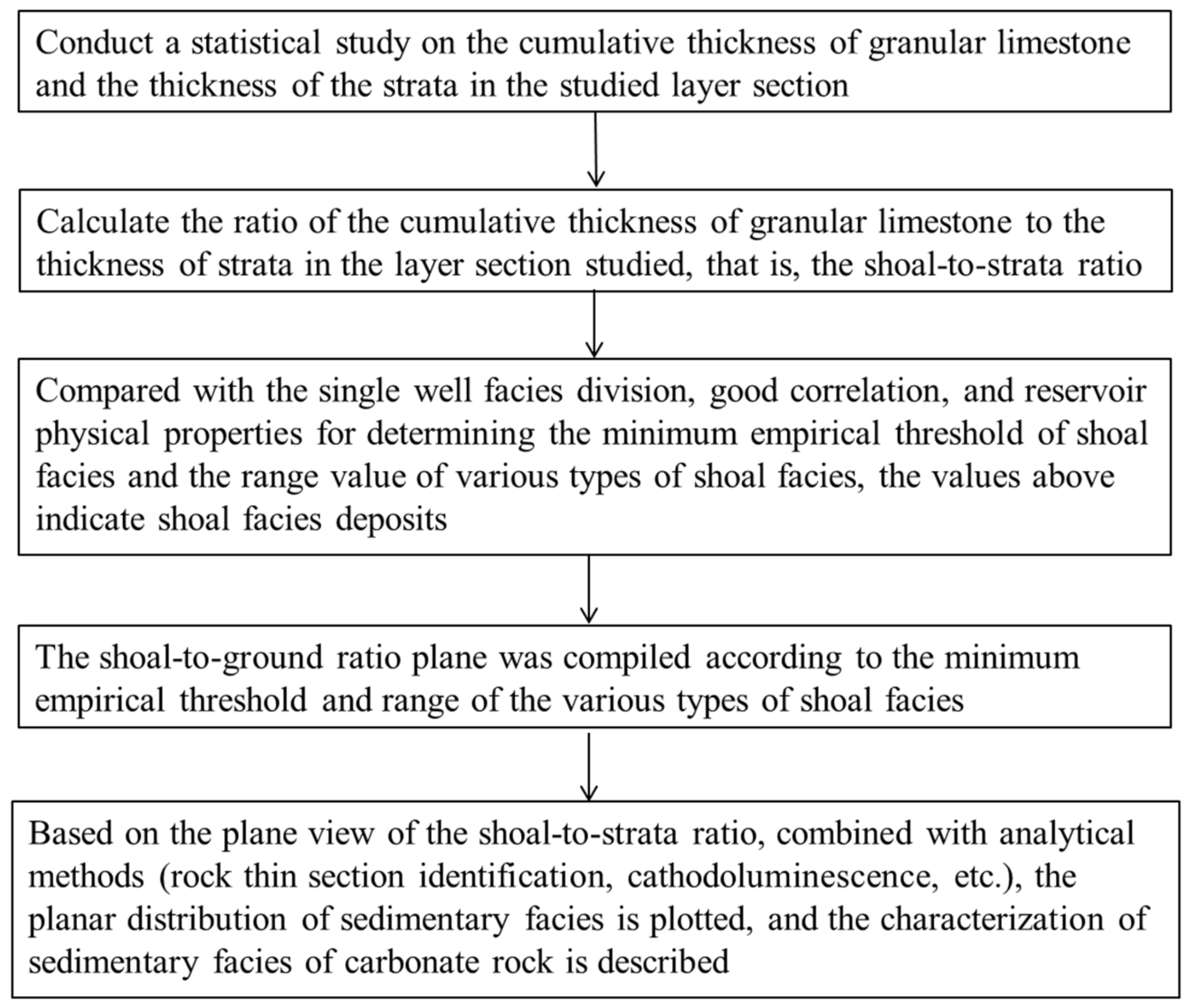
The workflow for the characterization of carbonate rock sedimentary facies using the shoal-to-strata ratio as a technical method is as follows (Figure 2):- (1)
-
Conduct a statistical study on the cumulative thickness of the granular limestone and the thickness of the strata in the studied layer section.
-
where h is the cumulative thickness of the granular limestone, n is the number of granular limestone layers, and hi is the thickness of the ith layer of granular limestone.h=∑ni=1hiwhere H is the thickness of the strata, D1 is the bottom depth of the studied layer section, and D2 is the top depth of the studied layer section.H=D1−D2
- (2)
-
Calculate the ratio of the cumulative thickness of the granular limestone to the thickness of the strata in the layer section under study, that is, the shoal-to-strata ratio.where R is the shoal-to-strata ratio, H is the thickness of the strata, and h is the cumulative thickness of granular limestone.R=hH
- (3)
-
Compared with the single-well facies division, good correlation, and reservoir physical properties for determining the minimum empirical threshold of shoal facies and the range value of various types of shoal facies, the values above indicate shoal facies deposits.
- (4)
-
The shoal-to-ground ratio plane was compiled according to the minimum empirical threshold and range of the various types of shoal facies.
- (5)
-
Based on the plane view of the shoal-to-strata ratio combined with analytical methods (rock thin section identification, cathodoluminescence, etc.), the planar distribution of sedimentary facies is plotted, and the characterization of sedimentary facies of carbonate rock is described.
 Figure 2.Flowchart of characterization of sedimentary facies of carbonate rocks using shoal-to-strata ratio.
4. Conclusions
- (1)
-
In areas where carbonate rock strata are eroded, the shoal-to-strata ratio can accurately reflect the types and distribution of granular shoals compared with the use of shoal thickness to classify the sedimentary facies of carbonate rocks. By comparing the ratio values, the types of shoal bodies can be determined more accurately, and the development of granular shoals in the studied layer section can be analyzed.
- (2)
-
A new view of the platform margin development in the Maokou Formation in Eastern Sichuan is proposed, and the platform margin shoal is an important reservoir. In the Eastern Sichuan area, the distribution of sedimentary facies belts of P2m2a is in the sequence of open platform, platform margin, slope, and basin, from southwest to northeast. Intra-platform low-energy shoals and sloping low-energy shoals are mainly distributed in areas with a shoal-to-strata ratio of 0.3–0.5, intra-platform high-energy shoals are distributed in areas with a ratio of 0.5–0.6, and platform margin shoals are mainly distributed in areas with a ratio of 0.6–0.8. The gas production test results show that deposits of shoal facies control oil and gas production, and platform margin shoals have greater exploration potential than intra-platform high-energy shoals.
- (3)
-
The planar distribution diagram of the shoal-to-strata ratio can be used as an important supporting map for compiling sedimentary facies. It can help researchers quickly and accurately determine sedimentary environments and make plans for future exploration. The application results are positive, indicating that this method is worth popularizing and applying in related research fields.
-
References
- Chen, G.H.; Wang, Z.W.; Li, D.Y.; Zhang, J.Y.; Xu, S.S. Auomatic discriminant sedimentary microfacies by means of multivarite statistics analysis. Pet. Geophys. 1997, 36, 71–76.
- Deng, R.; Meng, F.S. On Logging Curves Fine Delamination to Identify Sedimentary Microfacies. Well Logging Technol. 2010, 34, 554–558.
- Ruf, M.; Aigne, T. Facies and poroperm characteristics of a carbonate shoal (Muschelkalk South German Basin): A reservoir analogue investigation. J. Pet. Geol. 2004, 27, 215–239.
- Bádenas, B.; Aurell, M. Facies models of a shallow-water carbonate ramp based on distribution of non-skeletal grains (Kimmeridgian, Spain). Facies 2010, 56, 89–110.
- Kargarpour, M.A. Carbonate reservoir characterization: An integrated approach. J. Pet. Explor. Prod. Technol. 2020, 10, 2655–2667.
- Mancini, E.A. Integrated Geologic-Engineering Model for Reef and Carbonate Shoal Reservoirs Associated with Paleohighs: Upper Jurassic Smackover Formation, Northeastern Gulf of Mexico; University of Alabama: Tuscaloosa, AL, USA, 2003.
- Petrovic, A.; Aigner, T. Are shoal reservoirs discrete bodies: A coquina shoal outcrop analogue from the mid Triassic upper muschelkalk, SW Germany. J. Pet. Geol. 2017, 40, 249–275.
- Yu, Y.; Sun, L.; Song, X.; Guo, R.; Gao, X.; Lin, M.; Yi, L.; Han, H.; Li, F.; Liu, H. Sedimentary diagenesis of rudist shoal and its control on reservoirs: A case study of Cretaceous Mishrif Formation, H Oilfield, Iraq. Pet. Explor. Dev. 2018, 45, 1075–1087.
- Idan, R.M.; Salih, A.L.; Al-Khazraji, O.N.; Khudhair, M.H. Depositional Environments, Facies Distribution, and Porosity Analysis of Yamama Formation in Majnoon Oilfield. Sequence Stratigraphic Approach. Iraqi Geol. J. 2020, 53, 38–52.
- Abbas, L.K.; Mahdi, T.A. Reservoir Modeling of Mishrif Formation in Majnoon Oil Field, Southern Iraq. Iraqi Geol. J. 2020, 53, 89–101.
- Wang, H.; Zhou, Q.M.; Zhou, W.; Zhang, Y.D.; He, J.H. Carbonate Platform Reef-Shoal Reservoir Architecture Study and Characteristic Evaluation: A Case of S Field in Turkmenistan. Energies 2022, 15, 226.
- Lv, H.T.; Ding, W.L.; Yun, L.; Liu, Q. Middle-lower Ordovician carbonate reservoir karst-fracture characteristics in the southwest region of Tahe Oilfield. Geoscience 2009, 24, 699–708.
- Duan, J.B.; Ji, C.H.; Zhang, X.F. Development mechanism of reef reservoir of the Permian and Triassic strata in northern Sichuan Basin, China. J. Chengdu Univ. Technol. Nat. Sci. Ed. 2016, 43, 423–430.
- Li, R.B.; Fan, T.L.; Gao, Z.Q.; Hu, X.L. Characteristics and influencing factors of reservoirs in the Ordovician Yinshan Formation of the ka1 three dimensional seismic area within Katake uplift, Tarim basin. Geol. China 2011, 38, 1016–1025.
- Liu, H. The Development and Distribution Characteristics of Bank of Reservoir Changxing Formation in Yuanba Area. Master’s Thesis, Chengdu University of Technology, Chengdu, China, 2012.
- Tucker, M.E.; Wright, V.P. Carbonate Sedimentology; Blackwell Publishing: London, UK, 1990.
- Gao, Z.Q.; Fan, T.L.; Li, Y.; Liu, W.H.; Chen, Y.L. Study on Eustatic Sea-Level Change Rule in Cambrian-Ordovician in Tarim Basin. J. Jilin Univ. Earth Sci. Ed. 2006, 36, 50–552.
- Tan, X.C. Geological Model of Complicated Carbonate Reservoir with Multi-Cycle: Exampled by Jia2 Gas Pool of Moxi Structrue of Middle Sichuan. Ph.D. Thesis, Chengdu University of Technology, Chengdu, China, 2007.
- Zhao, J.X.; Li, F.J.; Liu, Q.; Jiang, B. Analysis on Permian Sedimentary Facies and Its Lithofacies Palaeogeographic Evolution, Northeast Sichuan Basin. Nat. Gas Sci. 2008, 19, 444–451.
- Flügel, E. Microfacies Analysis of Limestones; Springer: Berlin/Heidelberg, Germany, 1982; pp. 1–633.
- Balthaser, L.H. Microfacies Analysis of Limestones. Mar. Geol. 1983, 52, 303–304.
- Flügel, E. Microfacies of Carbonate Rocks; Springer: Berlin/Heidelberg, Germany, 2010.
- Chen, Y.Q. Distribution Regularity of Grain Beach of Middle Permian Maokou Formation in Eastern Sichuan and Its Control on Weathering Crust Karst. Master’s Thesis, Southwest Petroleum University, Chengdu, China, 2014.
- Luo, B.; Wang, W.F.; Chen, Y.Q.; Xiao, D.; Cheng, Y.; Li, S.; Xu, F.B.; Tan, X.C. Sedimentary Characteristics of Middle Permian Maokou Algal Framework Reef Rock in the East of Sichuan Basin. Mar. Orig. Pet. Geol. 2015, 20, 53–61.
- Wang, X.Z.; Tang, Y.; Yu, T.; Chen, J.Z. Restoration of karst landform of Maokou Formation in eastern Sichuan and its geological significance. China Pet. Chem. Stand. Qual. 2019, 39, 191–192.
- Chen, H. The Restoration of Sedimentary Paleogeomorphology of Maokou Formation of Lower Permian in East Sichuan and Karst Reservoir Research. Master’s Thesis, Chengdu University of Technology, Chengdu, China, 2020.
- Wang, H.; Shen, H.; Huang, D.; Shi, X.W.; Li, Y.; Yuan, X.L.; Yang, Y.R. Origin and distribution of hydrothermal dolomites of the Middle Permian in the Sichuan Basin. Nat. Gas Ind. 2014, 34, 25–32.
- Wang, L.J.; Yang, C.; Wang, Q.B.; Jia, G.G. Hydrothermal dolomite reservoir prediction for Maokou formation in Fuling area, Sichuan basin. Comput. Tech. Geophys. Geochem. Explor. 2018, 40, 298–305.
More
