Knowledge of river engineering impacts on water discharge is significant to flow guidelines
and sustainable water resource managements for balancing human consumption and the natural
environment. In this study, based on the collected multi-decadal discharge data at Yichang,
Hankou, and Datong stations, we determined that in October, Three Gorges Dam contributed
34.4%, 24.5%, and 18.7% to the discharge decrease in the upper, middle, and lower reach, respectively,
while Gezhouba Dam contributed 14.5%, 10.7%, and 10%. Danjiangkou Reservoir caused the
discharge ratio of Hanjiang to Changjiang to decline from 7.2% during 1954–1973 to 6.3% during
1973–2014. Owing to growing water withdrawal and consumption, we suggest that the distribution
of water diversion and consumption should be regulated to prevent the probable occurrence of the
severe issue of salt water intrusion in the Changjiang Estuary in 2028.
- river engineering
- water discharge
- Changjiang river
- influence factors
The water discharge of large rivers plays an important role in the economic development of drainage basins and the balance between continental freshwater and oceanic saltwater [1][2][3]. However, river engineering—such as dam construction and flow diversion, which have been carried out to control floods and meet the water, energy, and transportation needs of cities—has extensively altered mainstream discharge and caused changes in water resources all over the world [4][5][6][7][8]. Accordingly, it is of vital importance to determine how water discharge responds to the impacts of river engineering.
Dear author, the following contents are excerpts from your papers. They are editable.
Since the beginning of the Anthropocene, intensive human activities, especially a series of river projects, have exerted profound impacts on water discharge. Nilsson et al. [4] showed that over half of the large rivers worldwide (mean annual discharge anywhere in the catchment ≥350 m
3/s) were affected by dams so that the river systems were constrained and fragmented. Grill et al. [9] noted that only 37% of large rivers worldwide remain free-flowing without engineering interference and that 23% flow to the ocean uninterrupted. In the Eurasian Arctic, McClelland et al. [10] found that the dams of the six largest rivers dramatically changed the seasonality of the discharge but were irrelevant to the annual increase in discharge. Botter et al. [11] found a notable decrease in water discharge in response to the operation of the dam in the Piave River in Italy. In North America, Burke et al. [12] found that the minimum discharge increased and the duration of the dry season changed clearly under the impact of the operation of the Libby Dam in the Kootenai River. Mix et al. [13] concluded that building reservoirs in the upper Colorado River basin, Texas, USA, reduced the streamflow notably and exacerbated downstream hydrological droughts. In Southern Africa, agricultural water use accounts for nearly 33% of the water used from the Orange-Senqu River, which is much larger than the amount of water consumed through evaporation and riverine vegetation [14]. Although previous studies have paid attention to the impacts of dams or water use on discharge [13][14][15][16], few have conducted a comprehensive analysis of discharge variation in response to integrated river engineering involving dams, irrigation, water diversion projects, etc.
The Changjiang River is the longest river on the Asian continent and the third longest river in the world, and it receives substantial runoff at 905.5 billion m
3 [4][17]. It originates from the Qinghai-Tibet Plateau at an elevation of 6600 m, flowing into the East China Sea with a catchment area of 1.8 × 10
6
Figure 1). By convention, the Changjiang River is divided into three subsections: the upper section (from the source to Yichang), the middle section (from Yichang to Hankou), and the lower section (from Hankou to Datong) [16][20]. As Datong is the upstream limit of tidal influence, the section from Datong to the river mouth is defined as the estuary reach [21]. In China, nowhere has the impact of river engineering been more significant than the Changjiang River because almost half of the world’s large dams—of which the vertical depths are higher than 15 m—have been built here since 1950 [16]. In particular, the Changjiang River basin, where there are more than 400 million inhabitants, has the world’s largest dam, Three Gorges Dam (TGD), and large flow diversions, such as the South-to-North Water Diversion Project (SNWDP) (
In addition to the TGD, the Gezhouba Dam (GD) and the Danjiangkou Reservoir (DR) were constructed in the upper and middle reaches, respectively [16]. The expected capacity of these reservoirs is 300 billion m
3 by 2030 [22]. In addition, various types of water usage are noticeably increasing through intensive pumping in the Changjiang Basin [15]. With the operation of these large projects, the original pattern of Changjiang River water resources in the flood or dry season and different months has already changed [16][19][22][23][24][25][26][27]. Therefore, a holistic analysis of the impacts of river engineering on the water discharge of Changjiang is urgently required. Based on the available collected data, the aims of this research are (1) to examine the decadal water discharge variation in the Changjiang watershed, (2) to determine how river engineering influences the characteristics of discharge, and (3) to determine the variation trend in Changjiang water discharge in the future.
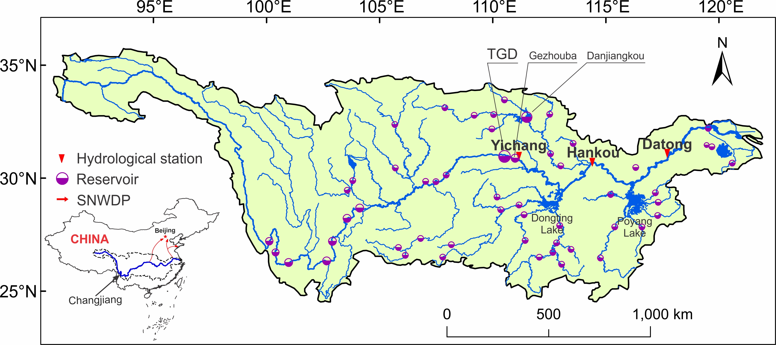
Figure 1.