The active emission of gas (mainly methane) from terrestrial and subsea permafrost in the Russian Arctic has been confirmed by ample evidence. A generalization and some systematization of gas manifestations recorded in the Russian Arctic is carried out. The published data on most typical gas emission cases have been summarized in a table and illustrated by a map. All events of onshore and shelf gas release are divided into natural and man-caused and the natural ones are further classified as venting from lakes or explosive emissions in dryland conditions that produce craters on the surface. a description of the observed man-caused gas manifestations associated with the drilling of geotechnical and production wells in the Arctic region is given.
- Russian Arctic
- Permafrost
- Gas Emissions
1. Introduction
Please note: Below is an entry draft based on your paper, which is wrirren tightly around the entry title. Since it may not be very comprehensive, we kindly invite you to modify it (both title and content can be replaced) according to your extensive expertise. We believe this entry would be beneficial to highlight your work.
Definition
The active emission of gas (mainly methane) from terrestrial and subsea permafrost in the Russian Arctic has been confirmed by ample evidence.
1. Introduction
The significant increase in atmospheric greenhouse gases, especially methane, in the Arctic regions is among the major causes of climate change and related environmental risks [1][2]. Warming in the Arctic induces degradation of permafrost and the ensuing dissociation of intra- and subpermafrost gas hydrates that maintain voluminous methane fluxes to the atmosphere [1][2][3][4][5][6]. Most natural methane emission occurs in water-logged depressed landforms, such as dried thaw lakes locally called khasyreys, or poorly flowing river arms and thermokarst sinkholes turned into lakes and swamps, etc. [7][8][9][10]. Active gas emission from the Arctic permafrost was observed during gas surveys of the near-surface atmosphere [8][11], the active layer, and water bodies [10][12][13][14][15][16][17][18][19]. Crater features on the surface record explosive emission of deep methane [20][21][22][23][24][25][26].
The significant increase in atmospheric greenhouse gases, especially methane, in the Arctic regions is among the major causes of climate change and related environmental risks [1,2]. Warming in the Arctic induces degradation of permafrost and the ensuing dissociation of intra- and subpermafrost gas hydrates that maintain voluminous methane fluxes to the atmosphere [1,2,3,4,5,6]. Most natural methane emission occurs in water-logged depressed landforms, such as dried thaw lakes locally called khasyreys, or poorly flowing river arms and thermokarst sinkholes turned into lakes and swamps, etc. [7,8,9,10]. Active gas emission from the Arctic permafrost was observed during gas surveys of the near-surface atmosphere [8,11], the active layer, and water bodies [10,12,13,14,15,16,17,18,19]. Crater features on the surface record explosive emission of deep methane [20,21,22,23,24,25,26].
The evidence of more or less intense gas release reported since the onset of petroleum exploration includes ejection of cuttings and mud, and even expulsion of drilling tools, from boreholes, drilling fluid degassing, etc. [27][28][29][30][31][32][33][34]. Gas shows of this kind were observed in northern West Siberia, Taymyr Peninsula, northern Yakutia, and northern Chukchi Peninsula.
The evidence of more or less intense gas release reported since the onset of petroleum exploration includes ejection of cuttings and mud, and even expulsion of drilling tools, from boreholes, drilling fluid degassing, etc. [27,28,29,30,31,32,33,34]. Gas shows of this kind were observed in northern West Siberia, Taymyr Peninsula, northern Yakutia, and northern Chukchi Peninsula.
Gas releases from both terrestrial and subsea permafrost, and numerous cases have been observed in the Arctic shelf for two recent decades. They are gas seeps and pockmarks found in the Barents and Kara Seas, nonpoint methane emissions in the Laptev and East Siberian Seas, local methane plumes in the East Siberian Sea, as well as gas blows while sampling from bottom sediments. Gas venting from shelf sediments has been attributed to the dissociation of gas hydrates in paleopermafrost [35][36][37][38]. The relation of methane venting from bottom sediments with gas hydrates on the Russian Arctic shelf has received no direct proof though, in the absence of test boreholes [39][40], but it was recently reported regarding the continental slope of the Russian Arctic in Chukchi Sea [41], and from other Arctic areas (Spitsbergen, Beaufort Sea, etc.) [42][43].
Gas releases from both terrestrial and subsea permafrost, and numerous cases have been observed in the Arctic shelf for two recent decades. They are gas seeps and pockmarks found in the Barents and Kara Seas, nonpoint methane emissions in the Laptev and East Siberian Seas, local methane plumes in the East Siberian Sea, as well as gas blows while sampling from bottom sediments. Gas venting from shelf sediments has been attributed to the dissociation of gas hydrates in paleopermafrost [35,36,37,38]. The relation of methane venting from bottom sediments with gas hydrates on the Russian Arctic shelf has received no direct proof though, in the absence of test boreholes [39,40], but it was recently reported regarding the continental slope of the Russian Arctic in Chukchi Sea [41], and from other Arctic areas (Spitsbergen, Beaufort Sea, etc.) [42,43].
2. Gas Emissions in the Russian Arctic
Purposeful studies of gas emissions in the Russian Arctic began about 60 years ago when the Urengoy (1966), Yamburg (1969), Bovanenkovo (1971), and other large gas fields were discovered in northern West Siberia. Many exploration and development people engaged in building infrastructure facilities and roads, drilling, and laying pipelines witnessed gas release from shallow monolith permafrost. It was the spontaneous blowout or prolonged release of combustible gas from geotechnical boreholes, or natural emission from Arctic Seas and lakes, which attracted the attention of geoscientists.
The reported cases can be conventionally divided into emissions from terrestrial and subsea (shelf) permafrost according to the place and into natural and anthropogenic according to the origin. Natural gas release on the land often occurs in river valleys, lakes, or swamps, or leaves traces as craters discovered in recent decades during exploration in the West Siberian Arctic.
Having reviewed the available relevant publications, we compiled a table showing the location, signatures, and possible gas sources for major known cases of gas release (
) and illustrated it with a map of gas emission sites in the Russian Arctic (
). Note that gas generation in the active layer is beyond the consideration in this study.
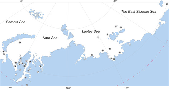
Figure 1.
Table 1. Known gas emission sites in the Russian Arctic.
Known gas emission sites in the Russian Arctic.
|
|
|
No. in map |
Type |
Location |
Signatures |
Possible gas sources |
Reference |
|
Onshore |
Natural |
1 |
Lakes |
Yamal Peninsula, Lake Neyto |
Gas plumes on water surface, mudflows, holes in ice |
Deep gas from Neyto field |
[10] |
|
2 |
Yamal Peninsula, Сrater Lake |
Craters and parapets on lake bottom, mudflows |
Possibly, deep gas-water fluids |
||||
|
3 |
Yamal Peninsula, group of lakes south of Bovanenkovo field |
Blue water, holes in ice, mudflows |
Active emission, possibly, deep gas |
[9] |
|||
|
4 |
Gydan Peninsula, a lake 4 km from Merkuto lake on the left bank of Yuribey River |
A crater encircled by a parapet |
Prolonged ascending flow, possibly, deep gas |
[9] |
|||
|
5 |
Yamal Peninsula, 54 km northeast of Arctic field, Otkrytie Lake |
Large craters (up to 40 m in diameter on lake bottom) |
Deep gas, possibly, from Cenomanian gas reservoirs |
[45] |
|||
|
6 |
Craters |
Yamal Peninsula, 30 km south of Bovanenkovo field |
A large crater (up to 40 m in diameter and ~70 m deep), encircled with a well-pronounced parapet; ground dispersed to a distance of 120 m |
Possibly, intrapermafrost gas |
|||
|
7 |
Gydan Peninsula, 100 km northwest of Antipayuta Village |
A crater, 10–13 m in diameter and ~15 m deep; no parapet |
Possibly, intrapermafrost gas |
[50] |
|||
|
8 |
Yamal Peninsula, floodplain of Erkuta-Yakha River |
A crater, 10–12 m in diameter and ~20 m deep, with a preserved fragment of a 2–3 m high mound and ground dispersed to a distance of 100 m |
Biogenic gas in a talik and deep gas |
[26] |
|||
|
9 |
Yamal Peninsula, 33 km northwest of Seyakha, Myudriyakha River |
Fire gas explosion that produced a 50 m deep 50 × 70 m crater in a river, with dispersed blocks of permafrost and ice-rich soil, up to 150 m3 |
Possibly, deep gas |
||||
|
|
|
10 |
|
Gydan Peninsula, north of Deryabino field, bank of Mongoche River |
Fire gas explosion that produced a 20 m deep crater, with dispersed large fragments of rock |
Possibly, deep gas |
|
|
Man-caused |
11 |
Drilling in permafrost |
North Yakutia, Anabar-Khatanga interfluve |
Gas shows at depths of 70–120 m |
Intrapermafrost gas |
[51] |
|
|
12 |
Yamal Peninsula, Yuribey River |
Gas shows at depths of 10–50 m |
Intrapermafrost gas |
||||
|
13 |
Taz Peninsula, Zapolyarny field |
Gas shows at depths of 50–120 m |
Intrapermafrost gas, possibly relict gas hydrates |
[30] |
|||
|
14 |
Taz Peninsula, Yamburg field |
Gas shows at depths of 45–55 m |
Intrapermafrost gas, possibly relict gas hydrates |
||||
|
15 |
Yamal Peninsula, Kharasavey field |
Gas shows at depths of 10–210 m |
Intrapermafrost gas, possibly relict gas hydrates |
||||
|
16 |
Yamal Peninsula, South-Tambey field |
Gas shows at depths of 40–60 m |
Intrapermafrost gas, possibly relict gas hydrates |
[57] |
|||
|
17 |
Gydan Peninsula, Pelyatka field |
Gas shows at depths of 20–30 m |
Intrapermafrost gas |
[30] |
|||
|
18 |
Gydan Peninsula, Salman (Utrenneye) field |
Gas shows at depths of 50–150 m |
Intrapermafrost gas, possibly relict gas hydrates |
[33] |
|||
|
19 |
Yamal Peninsula, Bovanenkovo field |
Gas shows at depths of 20–130 m |
Intrapermafrost gas, possibly relict gas hydrates |
||||
|
Offshore |
Natural |
20 |
Ascending flows and seeps |
Laptev Sea, Yana Delta |
Ebullition |
Deep gas |
|
|
21 |
East Siberian Sea, Bennett Island |
Gas plumes, up to 1000 km long |
Possibly, deep gas |
||||
|
22 |
Laptev Sea, between Semyonovsky Island and Lena Delta |
Gas seeps |
Possibly, deep gas |
[63] |
|||
|
23 |
Laptev Sea, Ivashkina Lagoon |
About 20 gas seeps; high concentration of methane in air |
Deep gas |
||||
|
24 |
Laptev Sea, Kotelny Island |
Gas seeps |
Possibly, deep gas |
[67] |
|||
|
25 |
Laptev Sea shelf, New Siberian Islands |
A cluster of gas seeps at 50–90 m sea depths |
Possibly, deep gas |
[68] |
|||
|
26 |
Laptev Sea (between 76.5° and 77.5° N; 121–132° E) |
More than 700 gas seeps, up to 1.3 km in diameter |
Possibly, deep gas |
||||
|
27 |
Chukchi Sea, Herald Canyon and Wrangel Island |
About 90 gas seeps at 50–95 m sea depths |
Deep gas |
||||
|
28 |
Kara Sea, near Marre-Salle polar station |
Gas seep at 6 m sea depths: 2 m in height and 15 m in width |
Biogenic gas |
[73] |
|||
|
29 |
Kara Sea, Universitetskaya structure |
Gas seeps from a depth of 80 m and pingo-like features |
Deep gas |
||||
|
Man made |
30 |
Drilling in subsea permafrost |
Pechora Sea, Kara Gates |
10 m high gas fountain from a borehole at sub-bottom depth 50 m |
Deep gas |
||
|
31 |
Pechora Sea, Vaygach Island |
10 m high gas fountain from a borehole at sub-bottom depth 50 m, with an ebullition zone up to 200 m in diameter on the sea surface |
Gas from subsea permafrost |
||||
|
32 |
Kara Sea, Baydaratskaya Bay |
Gas show from sub-bottom depth 10–50 m |
Possibly, deep gas |
[78] |
|||
|
33 |
Kara Sea, Leningrad field |
Gas show from a 200 m deep borehole |
Possibly, deep gas |
[78] |
|||
|
34 |
Laptev Sea, Lena Delta |
Gas show from a borehole at 9 m depth |
Gas from permafrost |
[79] |
|||
|
35 |
Laptev Sea, Buor-Khaya Gulf |
Gas show from a 13–16 m deep borehole |
Gas from permafrost |
[79] |
|||
|
36 |
Laptev Sea, Mamontov Klyk Cape |
Gas show from boreholes up to 80 m deep |
Gas from permafrost |
[80] |
|||
|
|
No. in map |
Type |
Location |
Signatures |
Possible gas sources |
Reference |
|
|
Onshore |
Natural |
1 |
Lakes |
Yamal Peninsula, Lake Neyto |
Gas plumes on water surface, mudflows, holes in ice |
Deep gas from Neyto field |
[10] |
|
2 |
Yamal Peninsula, Сrater Lake |
Craters and parapets on lake bottom, mudflows |
Possibly, deep gas-water fluids |
[10,44] |
|||
|
3 |
Yamal Peninsula, group of lakes south of Bovanenkovo field |
Blue water, holes in ice, mudflows |
Active emission, possibly, deep gas |
[9] |
|||
|
4 |
Gydan Peninsula, a lake 4 km from Merkuto lake on the left bank of Yuribey River |
A crater encircled by a parapet |
Prolonged ascending flow, possibly, deep gas |
[9] |
|||
|
5 |
Yamal Peninsula, 54 km northeast of Arctic field, Otkrytie Lake |
Large craters (up to 40 m in diameter on lake bottom) |
Deep gas, possibly, from Cenomanian gas reservoirs |
[45] |
|||
|
6 |
Craters |
Yamal Peninsula, 30 km south of Bovanenkovo field |
A large crater (up to 40 m in diameter and ~70 m deep), encircled with a well-pronounced parapet; ground dispersed to a distance of 120 m |
Possibly, intrapermafrost gas |
[22,44,46–49] |
||
|
7 |
Gydan Peninsula, 100 km northwest of Antipayuta Village |
A crater, 10–13 m in diameter and ~15 m deep; no parapet |
Possibly, intrapermafrost gas |
[50] |
|||
|
8 |
Yamal Peninsula, floodplain of Erkuta-Yakha River |
A crater, 10–12 m in diameter and ~20 m deep, with a preserved fragment of a 2–3 m high mound and ground dispersed to a distance of 100 m |
Biogenic gas in a talik and deep gas |
[26] |
|||
|
9 |
Yamal Peninsula, 33 km northwest of Seyakha, Myudriyakha River |
Fire gas explosion that produced a 50 m deep 50 × 70 m crater in a river, with dispersed blocks of permafrost and ice-rich soil, up to 150 m3 |
Possibly, deep gas |
[24,45] |
|||
|
|
10 |
Gydan Peninsula, north of Deryabino field, bank of Mongoche River |
Fire gas explosion that produced a 20 m deep crater, with dispersed large fragments of rock |
Possibly, deep gas |
[9,25] |
||
|
Man-caused |
11 |
Drilling in permafrost |
North Yakutia, Anabar-Khatanga interfluve |
Gas shows at depths of 70–120 m |
Intrapermafrost gas |
[51] |
|
|
12 |
Yamal Peninsula, Yuribey River |
Gas shows at depths of 10–50 m |
Intrapermafrost gas |
[52,53] |
|||
|
13 |
Taz Peninsula, Zapolyarny field |
Gas shows at depths of 50–120 m |
Intrapermafrost gas, possibly relict gas hydrates |
[30] |
|||
|
14 |
Taz Peninsula, Yamburg field |
Gas shows at depths of 45–55 m |
Intrapermafrost gas, possibly relict gas hydrates |
[30,54] |
|||
|
15 |
Yamal Peninsula, Kharasavey field |
Gas shows at depths of 10–210 m |
Intrapermafrost gas, possibly relict gas hydrates |
[55,56] |
|||
|
16 |
Yamal Peninsula, South-Tambey field |
Gas shows at depths of 40–60 m |
Intrapermafrost gas, possibly relict gas hydrates |
[57] |
|||
|
17 |
Gydan Peninsula, Pelyatka field |
Gas shows at depths of 20–30 m |
Intrapermafrost gas |
[30] |
|||
|
18 |
Gydan Peninsula, Salman (Utrenneye) field |
Gas shows at depths of 50–150 m |
Intrapermafrost gas, possibly relict gas hydrates |
[33] |
|||
|
19 |
Yamal Peninsula, Bovanenkovo field |
Gas shows at depths of 20–130 m |
Intrapermafrost gas, possibly relict gas hydrates |
[28,56,58–60] |
|||
|
Offshore |
Natural |
20 |
Ascending flows and seeps |
Laptev Sea, Yana Delta |
Ebullition |
Deep gas |
[30,61] |
|
21 |
East Siberian Sea, Bennett Island |
Gas plumes, up to 1000 km long |
Possibly, deep gas |
[61,62] |
|||
|
22 |
Laptev Sea, between Semyonovsky Island and Lena Delta |
Gas seeps |
Possibly, deep gas |
[63] |
|||
|
23 |
Laptev Sea, Ivashkina Lagoon |
About 20 gas seeps; high concentration of methane in air |
Deep gas |
[64–66] |
|||
|
24 |
Laptev Sea, Kotelny Island |
Gas seeps |
Possibly, deep gas |
[67] |
|||
|
25 |
Laptev Sea shelf, New Siberian Islands |
A cluster of gas seeps at 50–90 m sea depths |
Possibly, deep gas |
[68] |
|||
|
26 |
Laptev Sea (between 76.5° and 77.5° N; 121–132° E) |
More than 700 gas seeps, up to 1.3 km in diameter |
Possibly, deep gas |
[66,69] |
|||
|
27 |
Chukchi Sea, Herald Canyon and Wrangel Island |
About 90 gas seeps at 50–95 m sea depths |
Deep gas |
[70–72] |
|||
|
28 |
Kara Sea, near Marre-Salle polar station |
Gas seep at 6 m sea depths: 2 m in height and 15 m in width |
Biogenic gas |
[73] |
|||
|
29 |
Kara Sea, Universitetskaya structure |
Gas seeps from a depth of 80 m and pingo-like features |
Deep gas |
[74,75] |
|||
|
Man made |
30 |
Drilling in subsea permafrost |
Pechora Sea, Kara Gates |
10 m high gas fountain from a borehole at sub-bottom depth 50 m |
Deep gas |
[53,54] |
|
|
31 |
Pechora Sea, Vaygach Island |
10 m high gas fountain from a borehole at sub-bottom depth 50 m, with an ebullition zone up to 200 m in diameter on the sea surface |
Gas from subsea permafrost |
[76,77] |
|||
|
32 |
Kara Sea, Baydaratskaya Bay |
Gas show from sub-bottom depth 10–50 m |
Possibly, deep gas |
[78] |
|||
|
33 |
Kara Sea, Leningrad field |
Gas show from a 200 m deep borehole |
Possibly, deep gas |
[78] |
|||
|
34 |
Laptev Sea, Lena Delta |
Gas show from a borehole at 9 m depth |
Gas from permafrost |
[79] |
|||
|
35 |
Laptev Sea, Buor-Khaya Gulf |
Gas show from a 13–16 m deep borehole |
Gas from permafrost |
[79] |
|||
|
36 |
Laptev Sea, Mamontov Klyk Cape |
Gas show from boreholes up to 80 m deep |
Gas from permafrost |
[80] |
|||
3. Discussion
3. Discussion
The suggested inventory of the available data on gas emissions in the Russian Arctic collected for about 50 years follows a previous overview by Are of 1998 [53] which summarized the evidence available at that time. Are [53] characterized the forms and signatures of gas fluid venting in different areas of the Arctic controlled by the specificity of the gas sources. We provide more recent evidence and present the data in a table and in a map (
;
), arranged according to the location of emission sites (in lakes, on the land, or on the shelf), with the indication of specific signatures and possible sources of gas. This synthesis can provide a basis for the prediction of natural and man-caused gas release hazards for areas of observed methane emissions in the Arctic region.
Gas venting from Arctic lakes has the following signatures (for the described major cases, without considering ongoing methane generation in lake sediments):
-
− Greenish-blue transparent water, often with a visible lake bottom;
-
− Craters and similar features on the lake bottom;
-
− More or less strongly eroded parapet or rock fragments around craters as evidence of explosive emission;
-
− Mudflows in clear water associated with the release of a gas-water mixture through muddy bottom sediments;
-
− Ebullition;
-
− Bubbles of various shapes entrapped in ice;
-
− Ice holes persistent over the winter season, through which gas fluids vent to the air.
The review of published evidence on deep gas-emission craters (
), along with our field and laboratory data [26], allows a number of inferences:
-
− In the witnessed cases, gas release was accompanied by explosions and fire;
-
− All gas analyses showed the presence of methane;
-
− Many of the gas-emission events were preceded by heaving that produced meters high mounds;
-
− All discovered craters were round in shape but differed in size and depth, up to tens of m;
-
− In all cases, rocks around the craters contained ground or pore ice evident in the crater walls or in the ejected fragments;
-
− Most of the craters were encircled by parapets of ejected rock and soil; rock fragments were dispersed to distances of 100 m or farther around;
-
− Most of the craters became filled with water and transformed into lakes in two or three years after the emission event.
Gas release from geotechnical or producing boreholes in the Arctic region (especially in northern West Siberia) has the following common features:
-
− Gas most often releases from shallow permafrost at depths from 10–20 m to 150 m;
-
− Gas flux ranges from seeping to explosions at rates of hundreds to thousands of m3/d;
-
− Gas emission can last from a few minutes to a month or longer;
-
− Most of the emission events are known from oil and gas fields in northern West Siberia (Yamal, Taz, and Gydan Peninsulas);
-
− Gas released from rocks of different lithologies, but most often from sandy-loam and sandy horizons with low salinity;
-
− Gas emission occurs from ice-rich permafrost;
-
− Gas mostly consists of methane and smaller amounts of nitrogen and carbon dioxide;
-
− The carbon isotope composition of gas indicates its biogenic origin (−65 to −75‰ PDB δ13C);
-
− Intrapermafrost gas can exist in a free or hydrate form; the presence of free gas is limited by the amount of pore ice while gas hydrates can remain stable within a certain range of pressures and temperatures (hydrate stability zone); metastable relict hydrates that formed under favorable conditions in the past can survive due to self-preservation [33][81][82][83][33,85,101,102].
The available data on gas emissions in the Russian Arctic shelf show that
-
− High methane concentrations in surface waters of the Arctic shelf may have different causes, among which degradation of subsea permafrost, dissociation of intra- or subpermafrost gas hydrates, and formation of gas-permeable taliks [3][5][38][73][3,5,38,73];
-
− Methane in most of the gas seeps is of deep-seated (thermogenic) origin;
-
− Water column transfer of methane occurs by diffusive and ebullition mechanisms; gas migration in bubbles produces seeps and plumes; gas vents to the atmosphere if bubbles reach sizes at least 3–4 mm;
-
− Gas emission can arise when drilling strips intra- or subpermafrost gas accumulations or can result from the destabilization of gas hydrates;
-
− Pockmarks or plow marks are implicit indicators of gas venting on the Arctic shelf.
-
4. Conclusions
We have synthesized the available extensive published evidence on gas emissions in the continental and shelf areas of the Russian Arctic and presented the data in a table and in a map (
;
). The table shows the location, signatures, and possible sources of gas emission, with reference to relevant publications. Gas emission can be natural or anthropogenic; natural venting is possible in lakes and can be explosive, with the formation of craters. The characterized natural gas emission events have implications for gas transport mechanisms in terrestrial and subsea permafrost. Anthropogenic emission cases, which are most often related to drilling, differ in stripping depth of the gas-saturated permafrost, as well as in characteristics and duration of events.Although the tabulated and mapped gas emission data are limited to the most active, large, and well-documented cases, the overview provides an idea of the extent and main trends of the process.