The coverage path planning (CPP) algorithms aim to cover the total area of interest with minimum overlapping. The goal of the CPP algorithms is to minimize the total covering path and execution time. Significant research has been done in robotics, particularly for multi-unmanned unmanned aerial vehicles (UAVs) cooperation and energy efficiency in CPP problems. This paper presents a review of the early-stage CPP methods in the robotics field. Furthermore, we discuss multi-UAV CPP strategies and focus on energy-saving CPP algorithms. Likewise, we aim to present a comparison between energy-efficient CPP algorithms and directions for future research.
1. Introduction
In recent years, due to rapid technological development, UAVs and sensors they can carry have been developed to the extent that they can cover a wide range of applications
[1] that cannot be satisfied by other types of robots
[2]. Some of the applications are precision agriculture
[3][4][3,4], search and rescue
[5], firefighting
[6], law enforcement
[7], powerline inspection
[8], oil and gas
[9], disaster management
[10], and cell network expansion
[11]. However, a fundamental problem is the optimal use of autonomous aircraft in terms of time and space
[2].
Recently, CPP algorithms have been developed, considering the parameters required for more efficient data retrieval from remote sensing sensors
[12][13][12,13]. In addition, algorithms have been developed that use multi-UAV to cover the area, thus reducing the coverage time of the area of interest
[14][15][14,15]. The way to cover an area with autonomous robots differs depending on the algorithm
[2][16][17][2,16,17]. In the literature, CPP algorithms use different methods (e.g., grids, graphs, and neural networks) with calculations performed online or offline for known or unknown areas
[18].
The CPP algorithms can be classified into two main categories: offline and online
[19]. Offline algorithms need to know the environment and the information included, such as obstacles and the geometry of the area of interest. Of course, in a real-life environment, many dynamic parameters cannot be known in advance. Offline algorithms have prior knowledge of the coverage area environment
[20]. They also provide more efficient and convenient route plans and use less central processing unit (CPU) power than online algorithms
[21].
The online algorithms are based on real-time environment data retrieved from onboard sensors to cover the area of interest. Online algorithms do not fully understand the coverage area environment, and the coverage path is executed in real-time by the UAV after processing the data using the sensors it carries. The benefits of online algorithms are the design of the in-flight route to complete the mission regardless of unforeseen situations and the unnecessary prior detailed knowledge of the coverage area
[20][22][20,22].
Furthermore, there are two categories of problems in area coverage: single coverage and repeat coverage. The goal of single coverage is to cover the entire area of interest and, at the same time, minimize the time and distance traveled by the coverage route
[23]. On the other hand, repetitive coverage aims to repeatedly cover all points of interest in the area, maximize the frequency of visits to points of interest, and minimize time and total coverage
[24].
2. No Decomposition
T2. Methods
For the
pre
is no need for decomposition in areas with regular shapes and without complexity, such as rectangular areas. Patterns with simple path planning, such as boustrophedon or square, are adequate for total coverage of a non-complex area without overlapping. The boustrophedon method, which means “the way of the ox,” is a pattern of simple back and forth motion along the longest side of the polygon, as shown insent work, a systematic review research methodology was adopted. In that context, a range of platforms was sourced for information. Most of the sources cited in this survey were found in (a) the IEEE Xplore digital library, (b) the Google scholar platform, (c) the online Elsevier platform, and d) the online Figure 1MDPI [25][26][27].
Figure 1. Boustrophedon pattern.
The pl
iterat
ure assumform.
Ke
ywords
that the actual path is closely true to the plan when this utilized were: “Coverage Path Planning”, “Decomposition methods”, “CPP method
is executed from a ground vehicle. On the other hand, UAVs are aerodynamically directly affected by the direction and intensity of the wind, which means that the actual trajectory of the flight in most cases is not close to that planned.
The squs”, “Multi-robot CPP methods”, “Cell decomposition”, “Unmanned Aerial Vehicles”, “Energy optimal path”, “Energy-aware approaches”, “Multi-robot systems”, “Robot coverage”, “Robot kinema
re met
hod is represented by Andersen [28]ics”, and
it“UAV is a pattern for a search and rescue mission. The flight path is straight lines with right 90 degrees turns. The pattern starts from the center of the area of interest and expands until the borders, as shown inRemote Sensing”. Initially, the resulting papers (approximately 170) were filtered by choosing Figure 2.
Figure 2. Square pattern.
3. Exact Cellular Decomposition
Tthe
cellular deco
mposition methods are based on dividing an irregular space into cells. One class of these methods is the exact one. The exact cellular nes referring to CPP algorithms, decomposition method
decomposes the irregular space into cells, multi-robots, and
their connections produce an accurate free space composition. Accurate methods are complete becausmulti-UAV coverage path strategies, and energy-awareness CPP algorithms.
The
they170 guarantee the finding of an accessible path, if anyaforementioned publications [29]. The sub-are
as that arvi
se fromewed for the decomposition
can be covered from a methods, single
UAV or multi
ple UAVs. There are patterns for a single UAV, such as boustrophedon and spiral for polygon and concave areas. Nevertheless, there are strategies for the cooperation of multiple UAVs in order to minimize the coverage tim-robot CPP strategies, multi-UAV CPP methods, and UAV energy-saving algorithms. From the 170 papers, 128 were classified according to the
[30].
4. Trapezoidal Decomposition
One exact cellular decomposition technique for irregular spaces that can give a complete coverage path is trapezoidal decomposition. This method is classified in the offline category of algorithms because it does not use remote-sensing information [31][32]. Each cell is a trapezoid in this method, and simple methods such as back and forth can be used to cover every cell. The coverage can be achieved by an exhaustive walk that generates a path to cover each cell to execute the path using back and forth motions such as boustrophedon, as shown in Figure 3. Often, this method is used for agriculture applications where the fields are polygonal and clear from obstacles. Oksanen and Visala [33] introduced an algorithm for CPP in agricultural fields and used the path cost function to optimize the final path.
Figure 3. Trapezoidal decomposition.
5. Boustrophedon Decomposition
Tr
ape
zoidal decomposition produces many cells, some of which can be merged. This characteristic is a disadvantage because as many cells exist, the coverage path will be longer. To overcome this limitation, a method that creates nonconvex cells is needed. The boustrophedon cellular decomposition is similar to trapezoidal decomposition but considers vertices in the area called critical pointlevance of the survey’s scope and their overlapping information. In the end, 128 papers were analyzed for their approaches and their correlation to categorize in sub-sections
[25][27]. The bo
ustrophedonf decomposition
reduces the number of cells compared with trapezoidal decomposition,methods, CPP methods, and energy-saving algorithm, of which
means shorter path planning, as shown in Figure 4. As 88 made it into the
tr
apezoidal decomposition, this method is for polygonal areas, and the environmentefined version of the
coverage area should be knownpresent survey.
F
3. Results
Cho
r this
reason, it canet [19] be classified
as an offline method.
Figure 4. Boustrophedon decomposition.
6. Morse-Based Decomposition
Anothe CPP algorithms according to the
r cellular decomposition
method proposed by Acar et al. [34] is based on Mused. Most CPP algor
se funcit
ions [35]. Th
e Morse-bams
ed decompos
ition method has the advantage of differente the area of interest in cells
shapes such as circular and can be applied in any dimensional space, such as concave, polygon, and . This method is preferable for irregular
space. The cell decomposition is succeeded with a slice that sweeps through thareas. On the other hand, when the area of interest
. A slice is discontinued at the critical point of the Morse function, which is restricted from is a regular shape, it does not require any decomposition for single coverage of UAV. Table 1 at the
obstacle
boundaries, as shown in Figure 5. Tnd of this
mse
thod uses information concerning the area during motion planning. For this reason, the ction summarizes the decomposition method
can be classified as online [36][37].
Figure 5. Morse-based decomposition.
7. Online Topological Coverage Algorithm
Wong [38] s and present
ed an algorithm that finds the
cell boundaries online using slice decomposition. SlicCPP approach, the decomposition
is a method
for determining the cell boundaries using a sweeping line over, the algorithm processing, the shape of the area of interest
. As the line sweeps over the area, it separates the obstacles and free space in two regions or more, as shown in , and the corresponding reference.
3.1. No Decomposition
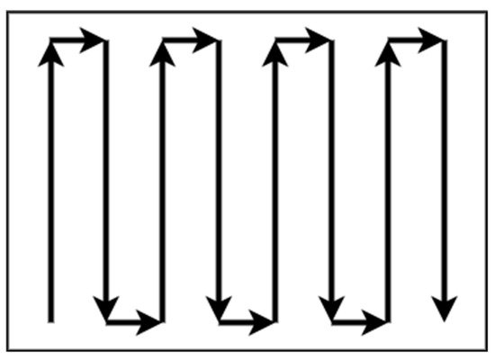
There is no need for decomposition in areas with regular shapes and without complexity, such as rectangular areas. Patterns with simple path planning, such as boustrophedon or square, are adequate for total coverage of a non-complex area without overlapping. The boustrophedon method, which means “the way of the ox,” is a pattern of simple back and forth motion along the longest side of the polygon, as shown in Figure 1 [33,34,35].
Figure 1. Boustrophedon pattern.
The literature assumes that the actual path is closely true to the plan when this method is executed from a ground vehicle. On the other hand, UAVs are aerodynamically directly affected by the direction and intensity of the wind, which means that the actual trajectory of the flight in most cases is not close to that planned.
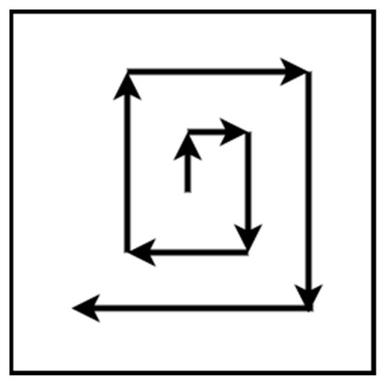
The square method is represented by Andersen [36], and it is a pattern for a search and rescue mission. The flight path is straight lines with right 90 degrees turns. The pattern starts from the center of the area of interest and expands until the borders, as shown in Figure 6. The algorithm constructs a topological map using the slice decomposition on the area of interest [39].Figure 62. Slicquare decompositiopattern.
3.2. Exact Cellular Decomposition
The cellular decomposition methods are based on dividing an irregular space into cells. One class of these methods is the exact one. The exact cellular decomposition method decomposes the irregular space into cells, and their connections produce an accurate free space composition. Accurate methods are complete because they guarantee the finding of an accessible path, if any [37]. The sub-areas that arise from the decomposition can be covered from a single UAV or multiple UAVs. There are patterns for a single UAV, such as boustrophedon and spiral for polygon and concave areas. Nevertheless, there are strategies for the cooperation of multiple UAVs in order to minimize the coverage time [38].
8. Contact Sensor-Based Coverage of Rectilinear Environments
Butl
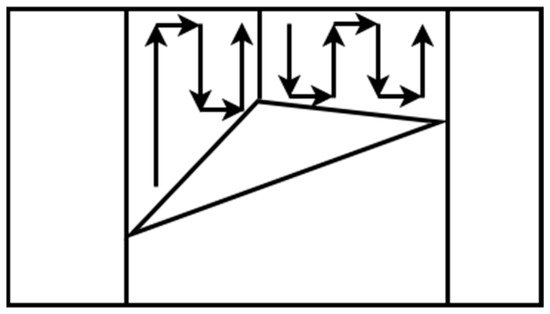
3.3. Trapezoidal Decomposition
One
r e
t al. [40] present an exact ce
ll
lular decomposition
algorithm for contact sensor-based robots for online coverage of the rectilinear environment. In contact sensor-based coverage, the robot’s path is cycling with retracing, while at the same time it repeatedly constructs a cellular decomposition of the area of interest. When a robot’s full-cycle path is unsuccessful, it chooses a newtechnique for irregular spaces that can give a complete coverage path
based on its position and environment. The robot’s motion depends on the area’s celis trapezoidal decomposition
state, updated as the CPP progresses.
9. Grid-Based Methods
Gr. Thi
d-bas
ed method
s are is classified
as approximate cellular decomposition due to the restriction of the grid’s shape, which is uniform in space. It is impossible to represent precisely the shape of the target space and its obstacles [19]. Thin the offline category of algorithms because
gri
d-based methods decomposed the space into uniform grid cells, which can be squares or other shapes, as shown in Figure 7. Moravec and Elt does not use remote-sensing inf
es [41] pro
posed a gr
id map presentmation
based[39,40]. on Ea
sonar mounted on a mobile robot mapping an indoor environment.
Figure 7. Grid-based decomposition.
9.1. Wavefront Algorithm
Tch cell is a trapezoid in th
e fi
rst CPP’s grid-based s method
was proposed by Zelinsky et al. [42]. Th, and simple
ir method
has a start cell and a goal cell. A grid represents ts such as back and forth can be used to cover every cell. The coverage
area, and a wavefront algorithm is used from the goal cell to the start cell. Its operation is based on propagating a “wavefront” from the targetcan be achieved by an exhaustive walk that generates a path to cover each cell
passing through the free cells and bypassing all obstacles to the starting cell.
More sto execute the p
ecifica
lly, the transmission of the “wavefront” from the target cell to the starting cell is used to assign specific numbers to each cell of the gridth using back and forth motions such as boustrophedon, as shown in
Figure 83.
FOften, thi
rstly, 0 is assigned to the target cell and then 1 to all adjacent cells. Then, all the other adjacent cells of 1 to which no number has been assigned ares method is used for agriculture applications where the fields are polygonal and clear from obstacles. Oksanen and Visala [41] assi
gned 2. The process repeats incrementally until the wavefront reaches the starting poinntroduced an algorithm for CPP in agricultural fields and used the path cost
[13][20]. The efun
vcti
ronment should be known in this method, so the method can be classified offlineon to optimize the final path.
Figure 3. Trapezoidal decomposition.
3.4. Boustrophedon Decomposition
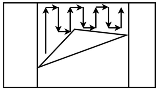
Trapezoidal decomposition produces many cells, some of which can be merged. This characteristic is a disadvantage because as many cells exist, the coverage path will be longer. To overcome this limitation, a method that creates nonconvex cells is needed. The boustrophedon cellular decomposition is similar to trapezoidal decomposition but considers vertices in the area called critical points [33,35]. The boustrophedon decomposition reduces the number of cells compared with trapezoidal decomposition, which means shorter path planning, as shown in Figure 4. As the trapezoidal decomposition, this method is for polygonal areas, and the environment of the coverage area should be known. For this reason, it can be classified as an offline method.
Figure 4. Boustrophedon decomposition.
3.5. Morse-Based Decomposition
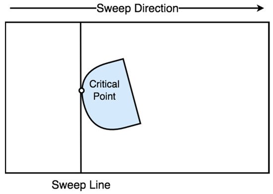
Another cellular decomposition method proposed by Acar et al. [42] is based on Morse functions [43]. The Morse-based decomposition method has the advantage of different cells shapes such as circular and can be applied in any dimensional space, such as concave, polygon, and irregular space. The cell decomposition is succeeded with a slice that sweeps through the area of interest. A slice is discontinued at the critical point of the Morse function, which is restricted from the obstacle boundaries, as shown in Figure 5. This method uses information concerning the area during motion planning. For this reason, the method can be classified as online [44,45].
Figure 5. Morse-based decomposition.
3.6. Online Topological Coverage Algorithm
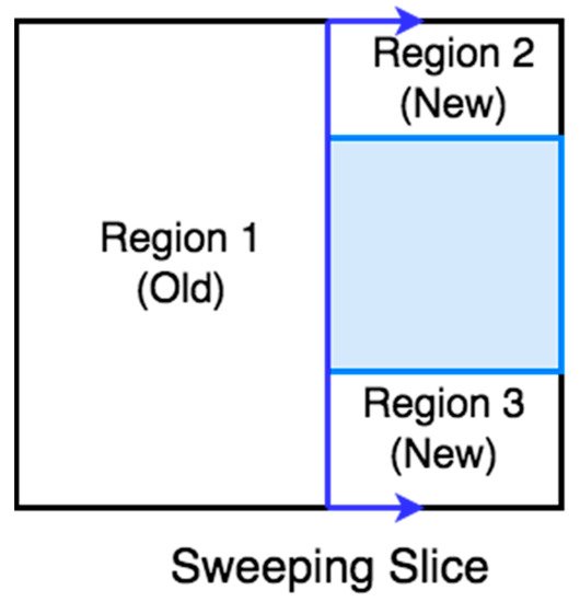
Wong [46] presented an algorithm that finds the cell boundaries online using slice decomposition. Slice decomposition is a method for determining the cell boundaries using a sweeping line over the area of interest. As the line sweeps over the area, it separates the obstacles and free space in two regions or more, as shown in Figure 6. The algorithm constructs a topological map using the slice decomposition on the area of interest [47].
Figure 6. Slice decomposition.
3.7. Contact Sensor-Based Coverage of Rectilinear Environments
Butler et al. [48] present an exact cell decomposition algorithm for contact sensor-based robots for online coverage of the rectilinear environment. In contact sensor-based coverage, the robot’s path is cycling with retracing, while at the same time it repeatedly constructs a cellular decomposition of the area of interest. When a robot’s full-cycle path is unsuccessful, it chooses a new path based on its position and environment. The robot’s motion depends on the area’s cell decomposition state, updated as the CPP progresses.
3.8. Grid-Based Methods
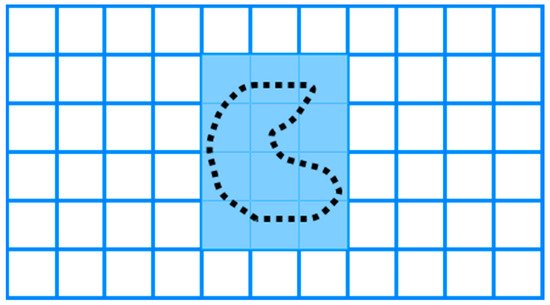
Grid-based methods are classified as approximate cellular decomposition due to the restriction of the grid’s shape, which is uniform in space. It is impossible to represent precisely the shape of the target space and its obstacles [19]. The grid-based methods decomposed the space into uniform grid cells, which can be squares or other shapes, as shown in Figure 7. Moravec and Elfes [49] proposed a grid map presentation based on a sonar mounted on a mobile robot mapping an indoor environment.
Figure 7. Grid-based decomposition.
3.8.1 Wavefront Algorithm
The first CPP’s grid-based method was proposed by Zelinsky et al. [50]. Their method has a start cell and a goal cell. A grid represents the coverage area, and a wavefront algorithm is used from the goal cell to the start cell. Its operation is based on propagating a “wavefront” from the target cell passing through the free cells and bypassing all obstacles to the starting cell.
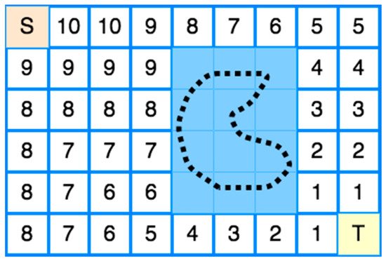
More specifically, the transmission of the “wavefront” from the target cell to the starting cell is used to assign specific numbers to each cell of the grid, as shown in Figure 8. Firstly, 0 is assigned to the target cell and then 1 to all adjacent cells. Then, all the other adjacent cells of 1 to which no number has been assigned are assigned 2. The process repeats incrementally until the wavefront reaches the starting point [13,20]. The environment should be known in this method, so the method can be classified offline.
Figure 8. Wavefront Transmission from starting cell (S) to target cell (T).
Nevertheless, Shivashankar et al. [43] proposed a wavefront algorithm to accomplish an online CPP with a mobile robot in an unknown spatial environment.Nevertheless, Shivashankar et al. [51] proposed a wavefront algorithm to accomplish an online CPP with a mobile robot in an unknown spatial environment.
9.2. Spanning Tree Coverage
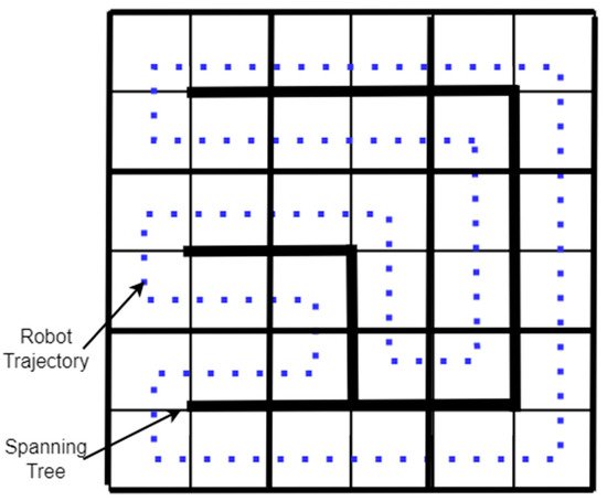
3.8.2 Spanning Tree Coverage
The spanning tree coverage (STC) algorithm solves the problem of covering an area using a robot [30]. The method used by the STC algorithm is first to decompose the region into cells and calculate a connecting tree of the resulting graph. Finally, the robot’s path starts near the “connecting tree” and follows its perimeter, as shown in The spanning tree coverage (STC) algorithm solves the problem of covering an area using a robot [38]. The method used by the STC algorithm is first to decompose the region into cells and calculate a connecting tree of the resulting graph. Finally, the robot’s path starts near the “connecting tree” and follows its perimeter, as shown in Figure 9 [29]. A Spiral-STC algorithm was proposed by Gabriely and Rimon [44]. This online method converts the space into a grid map. The mobile robots execute a spanning tree-generated spiral path using onboard sensors. [37]. A Spiral-STC algorithm was proposed by Gabriely and Rimon [52]. This online method converts the space into a grid map. The mobile robots execute a spanning tree-generated spiral path using onboard sensors.
Figure 9. Spanning Tree-based coverage.
10. Neural Network-Based Coverage on Grid Maps
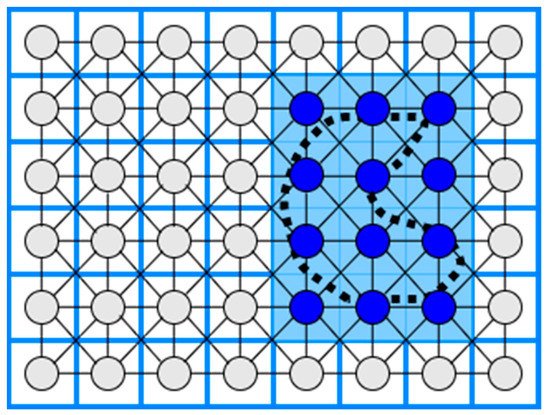
3.9. Neural Network-Based Coverage on Grid Maps
The CPP using a neural network is an online coverage method. First, in a 2D coverage area, a grid map is constructed where the length of the diagonal of each cell is equal to the coverage radius of the robot (e.g., the coverage radius of a robotic broom), and then a neuron is associated with each cell in the grid. Each neuron is connected to the eight primary neighboring neurons, as shown in
Figure 10. Finally, the robot’s path to the coverage area is executed by knowing each output value of each neuron at a given time, so that the robot is attracted to cells it has not visited while at the same time being rejected by cells it has visited [45][46].. Finally, the robot’s path to the coverage area is executed by knowing each output value of each neuron at a given time, so that the robot is attracted to cells it has not visited while at the same time being rejected by cells it has visited [53,54].
Table 1. CPP and decomposition methods.
| CPP Approach |
Decomposition Method |
Algorithm Processing |
Shape of Area |
Reference |
| Boustrophedon |
None |
Offline |
Rectangular |
[25][26] | [33 | [27] | ,34,35] |
| Square |
None |
Offline |
Square |
[28] | [36] |
| Boustrophedon, Spiral |
Exact cellular |
Offline |
Polygon, Concave |
[29] | [37] |
| Back and Forth |
Trapezoidal |
Offline |
Polygon |
[31][32] | [39,40] |
| Boustrophedon |
Boustrophedon |
Offline |
Polygon |
[25] | [33 | [27] | ,35] |
| Boustrophedon |
Morse-based |
Online |
Any dimensional |
[34] | [42] |
| Online Topological |
Slice |
Online |
Polygon |
[38] | [46] |
| Contact Sensor-based |
Exact cellular |
Online |
Rectilinear |
[40] | [48] |
| Wavefront |
Approximate cellular |
Offline |
Polygon, Concave |
[42] | [50] |
| Wavefront |
Approximate cellular |
Online |
Polygon, Concave |
[43] | [51] |
| STC |
Approximate cellular |
Offline |
Polygon, Concave |
[29] | [37] |
| Spiral-STC |
Approximate cellular |
Online |
Polygon, Concave |
[44] | [52] |
| Neural Network-based |
Approximate cellular |
Online |
Polygon, Concave |
[45][46] | [53,54] |
Figure 10. Neural Network-based coverage.
3.10. Multi-Robot CPP Strategies
Multiple robots have an advantage over single robotic systems [24]. The use of multiple robots accelerates coverage of an area of interest. The problem of covering an area with multiple robots lies in the calculation of optimal routes in order to minimize the coverage time [38]. Using multiple robots in a CPP work reduces the completion time due to workload division [20]. This section discusses multi-robot coverage methods based on single robot approaches, multi-robot strategies, and multiple UAVs to cover an area of interest. Some drawbacks of multiple UAV strategies are spatial orientation and communication difficulties. Table 2 at the end of this section summarizes the multi-robot CPP strategies and presents the CPP approach, the decomposition method, the algorithm processing, and the corresponding reference.
3.11. Multi-Robot Boustrophedon Decomposition
Rekleitis et al. [16] presented a set of online algorithms for solving the CPP using a group of mobile robots in an unknown environment. The algorithms employ the same planar cellular decomposition as the Boustrophedon single robot coverage algorithm, with additions to manage how robots cover a single cell and distribute among cells. Their solution takes into account the team members’ communication limitations. The robots serve two roles to accomplish coverage where some members, known as explorers, cover the boundaries of the actual target cell, while others, known as coverers, conduct basic back-and-forth motions to cover the cell.
3.12. Multi-Robot Spanning Tree Coverage
Their experimental data reveal that their technique outperforms multi-robot spanning tree coverage (MSTC) by a significant margin. Nevertheless, the coverage time of an area with the multi-robot forest coverage (MFC) algorithm is shorter than the MSTC algorithm [38]. Moreover, an online, robust version of MSTC was provided by Hazon et al. [55]. They show that the approach is robust analytically, providing as much coverage as a single robot can.
3.13. Multi-Robot Neural Network-Based Coverage
A neural network approach for multi-robot coverage where each robot sees all the others as obstacles and the avoidance ability of stalemate situations was proposed by Luo and Yang [54,56,57]. The multi-robot neural-network based coverage is inspired by single robot neural-network coverage. During the coverage of the irregular-shaped area of interest, the robots see each other as moving obstacles.
11. Multi-Robot CPP Strategies
3.14. Multi-Robot Graph-Based and Boundary Coverage
Easton and Burdick [58] presented a two-dimensional boundary coverage method for multiple robots. A team of robots must inspect all points on the boundary of the two-dimensional target environment, and each robot’s inspection routes are planned to use a heuristic search. The planned paths cover the entire boundary. Moreover, the algorithm has been validated by simulations. The multi-robot boundary coverage is inspired by the need to inspect the blade surfaces inside a turbine.
Table 2. Multi-robot CPP strategies.
| CPP Approach |
Decomposition Method |
Algorithm Processing |
Reference |
| Boustrophedon |
Exact cellular |
Online |
[16] |
| Spanning Tree Coverage |
Approximate cellular |
Online |
[55] |
| Neural network-based |
Approximate cellular |
Online |
[54,56,57] |
| Graph-based and Boundary |
Approximate cellular |
Offline |
[58] |
3.15. Multi-UAV CPP Methods
The number of applications where UAVs can be used is increasing as remote-sensing technology is developed. In the literature, there are a lot of multi-UAV CPP methods using different coverage algorithms with heterogeneous or homogeneous UAVs that were used in a variety of applications, such as agriculture [59], surveillance [60], mapping [61], and search and rescue missions [62]. Table 3 at the end of this section summarizes the multi-UAV CPP strategies and presents the CPP approach, the type of UAVs, the algorithm processing, the evaluation metrics, and the corresponding reference.
3.16. Multi-UAV Coverage
In the agricultural sector, Barrientos et al. [13] proposed a method for area coverage using a fleet of mini aerial robots. Their method divides the area of interest in k non-overlapping subtasks and assigns them in k UAVs. A decentralized method for surveillance missions using homogeneous UAVs was proposed by Acevedo et al. [63]. This method’s primary goal is to minimize latency, which means a short sharing time of information between the UAVs. In a later work, Acevedo et al. [64] developed a method for surveillance in urban environments with heterogeneous UAVs that fly at low altitudes and avoid obstacles. Finally, in their most recent work, Acevedo et al. [65] developed a method based on grid-shape area partition, which can readjust the area shape and UAVs’ capacity.
A terrain coverage method using a fleet of heterogeneous UAVs was presented by Maza and Ollero [61]. Their method divides the irregular-shaped area of interest per each UAV capability, such as total flight time. Each partition is assigned to a UAV that plans a zig-zag covering pattern according to the area’s characteristics to minimize the number of turns. The method was validated in simulation.
A coverage algorithm for fixed-wing UAVs with the ability for obstacle and previously scanned regions avoidance was presented by Xu et al. [23,66]. Their method uses boustrophedon cellular decomposition [33], an exact cellular decomposition, and presents better accuracy than trapezoidal decomposition. The method can be classified as online in the phase of region scanning and offline in the coverage phase.
3.17. Back-and-Forth
Maza and Ollero [61] present a cooperative technique using heterogeneous UAVs in a convex polygonal area. A ground control station divides the area into sub-regions and assigns them to every UAV by the capability and starting position. Every UAV calculates back-and-forth patterns according to the camera footprint to reduce the number of turns.
3.18. Spiral
Balampanis et al. [67,68] present a spiral CPP algorithm using multiple heterogeneous UAVs. The area of interest is divided according to UAVs sensing capabilities using a constrained Delaunay triangulation (CDT) [69]. The CDT generates triangle cells that match almost exactly the shape of the area of interest. To make the triangles more uniform, they applied Lloyd optimization [70]. Then, a spiral algorithm generates the coverage pattern for each sub-area. This method can generate smoother trajectories considering avoiding no-fly zones and the shape of the coverage area. However, it generates more extensive coverage paths and a higher number of turns than classical grid decomposition and motion methods [71,72].
3.19. Multi-Objective Path Planning (MOPP) with Genetic Algorithm (GA)
Hayat et al. [73] propose multi-objective path planning (MOPP) with a genetic algorithm (GA) for search and rescue missions using multiple UAVs. The mission is divided into two phases: search and response. The search phase monitors an event to guarantee the total coverage in a given area, and the response phase spreads detection updates on the network. The MOPP algorithm performs the planning task during the search, while the GA minimizes the mission completion time. As a result, the method can be classified as offline in the search phase and online in the response phase.
3.20. Genetic Algorithm (GA) with Flood Fill Algorithm
Based on the Trujillo et al. [74] approach, Darrah et al. [75] present a CPP method for missions over more extensive areas using multi-UAVs. The method produces equitable sub-areas of the area of interest to cover by multi-UAVs or several flights performed by a single UAV. The flood fill algorithm integrated with game theory was applied to partition the area of interest. Each UAV is a player and has a starting position. According to a predefined pattern in a diamond shape, the UAVs take turns flooding the neighbor cells. The UAVs cannot fly over building cells or cells previously occupied by other UAVs. The partitioning method guarantees an approximate amount of work for each assigned UAV by balancing the tasks. An improved version of the approach proposed by Trujillo et al. [74] was used for each sub-area’s coverage trajectories. The method can be classified initially as offline and then as online.
Table 3. Multi-UAV CPP strategies.
| CPP Approach |
Type of UAVs |
Algorithm Processing |
Evaluation Metrics |
Reference |
| Sub-perimeter method |
Homogeneous |
Online |
Minimize latency |
[63] |
| Back-and-Forth |
Homogeneous |
Online/Offline |
Total path length
Time coverage |
[23,66] |
| Back-and-Forth |
Heterogeneous |
Offline |
Number of turns |
[61] |
| Spiral |
Heterogeneous |
Offline |
Coverage path, Number of turns |
[67,68] |
| Multi-Objective Path Planning with GA |
Homogeneous |
Offline/Online |
Mission Completion Time |
[73] |
| GA with flood fill algorithm |
Homogeneous |
Offline/Online |
Path length |
[74,75] |
3.21. Energy-Saving CPP Algorithms
In the literature, there are a lot of CPP strategies for energy saving. One method for energy saving proposed by Lawrance and Sukkarieh [25] is the energy exploitation of the wind using a small gliding UAV. The authors present an algorithm that generates energy gain paths according to the UAV’s constraints, the field’s wind conditions, and static and dynamic soaring. One of the limitations of this method is the requirement for prior knowledge of the field’s wind conditions. In future research, an online stochastic wind estimation and planning method using current wind conditions of the field should be developed.
Another method for minimizing the power consumption of a UAV is reducing the number of turns of the CPP. Torres et al. [76] present an algorithm that reduces the number of turns and the total flying path to minimize battery consumption.
The effect of wind direction and intensity on the time of mission completion was presented by Coombes et al. [77]. The authors used a fixed-wing UAV and the boustrophedon method to cover the area of interest. Their simulated experiments used a constant direction of the wind and six different speeds, and for the coverage path used different directions of the fixed-wing UAV motion from 0 to 360 degrees in increments of 10 degrees. The results showed that the direction of the coverage path should be 90 degrees to the wind direction to minimize the coverage time. Furthermore, the direction of the turns is directly affected by the vertical component of the wind. In a later work, Coombes et al. [78] presented the flight time in wind (FTIW) function, which computes the total flight time for a total coverage of the area of interest. The flight time needed for the total coverage of the area is less than the previous methods. Their approach was validated after simulations and real flights.
An energy-efficient back and forth CPP algorithm proposed by Di Franco and Buttazzo [18] computes the best motion trajectory and the maximum altitude according to the ground sample distance (image resolution) to minimize the number of turns. Another approach for energy efficiency is to find an optimal constant speed according to the coverage path. An energy-aware spiral CPP algorithm uses wider angle turns to minimize the acceleration and deceleration to maintain an optimal constant speed Cabreira et al. [79]. After simulated and real flights, the most energy-efficient CPP method between energy-efficient back and forth CPP [18] and the energy-aware spiral CPP approach proposed by Cabreira et al. [79] for a convex area was the energy-aware spiral CPP method which adopted the energy model proposed by Di Franco and Buttazo [80].
Another energy-aware CPP algorithm for UAVs was proposed by Li et al. [81], where the algorithm has three stages. In the first stage, the algorithm builds a 3D terrain model. In the second stage, constant power consumption is computed by total take-off weight, flight speed, and air friction. In the third stage, a genetic algorithm generates an energy-optimal coverage path, which represents the amount of energy consumption in every part of the path.
Another problem concerning UAV energy consumption is the deceleration and acceleration at every turn of a conventional trajectory such as boustrophedon. Artemenko et al. [82] present an algorithm that modifies conventional trajectories using Bézier curves, smoothing the turns on a given path to minimize deceleration and acceleration before and after the turning point. The authors concluded that their algorithm could reduce energy spending compared to conventional algorithms. Restrictions, such as the UAV motion and camera’s location, can be overcome using integer linear programming. Ahmadzadeh et al. [83] present a cooperative coverage technique with critical time for rectangular areas utilizing several fixed-wing heterogeneous UAVs, some carrying a frontal camera, flying circular paths and some of them carrying a camera on the left side, flying straight lines with left turn paths. Their proposed method uses four fixed-wing UAVs covering 100% of the area of interest instead of the simple methods covering 80%. The proposal was validated in simulation tests and real flights.
Araujo et al. [84] propose an algorithm where the workspace is divided into sub-areas assigned to each UAV according to its relative capability. According to the kinematics constraints of the UAVs, the algorithm generates an optimal number of stripes to minimize the number of stripes and eventually the number of turns, which means less energy consumption.
Majeed and Lee [85] present a CPP method for UAV low-altitude navigation in three-dimensional urban areas with fixed convex obstacles based on footprint sweeps fitting and a sparse waypoint graph. The primary goals of the proposed approach are to reduce computational time, the number of turns, and path overlapping while minimizing the total coverage path of the area of interest. The suggested method outperforms the similarly related CPP approaches according to simulation findings.
In a later work, Majeed and Hwang [86] present a CPP algorithm for UAV navigation to cover areas of interest (AOIs) surrounded by obstacles in three-dimensional urban areas with fixed obstacles. The proposed method is applicable in a wide range of practical applications that involve computing a low-cost coverage for spatially distributed AOIs in an urban environment. However, the proposed algorithm has not incorporated and tested for constraints and limitations, such as image resolution and UAV battery.
Cheng et al. [87] present a bio-inspired method for cooperative coverage. This method represents the trajectory of each UAV as the B-spline curve containing control points. This optimization problem aims to maximize the desirability of a path by combining four variables: path distance, minimum turning angle, maximum pitch rate, and superposition of the actual trajectory over different UAV trajectories. According to the authors, the beginning and last control points are at the area’s borders because the UAV always travels from left to right. The ant colony optimization (ACO) algorithm was adapted for coverage with multiple UAVs by Kuiper and Nadjm-Tehrani [88]. The y-axis in the intermediate control points is optimized using the ACO algorithm to maximize the coverage. Several ants are launched during the algorithm repetitions, passing through the starting, intermediate, and endpoints.
Table 4 summarizes the energy-saving CPP methods reviewed in this paper according to the method used for energy saving. The table presents the CPP method, the energy-saving factor, the type of UAV, and the corresponding reference.
Table 4. CPP energy-aware methods.
| CPP Method |
Energy-Saving Approach |
Type of UAV |
Reference |
| Energy gain path |
Energy exploitation of the wind |
Fixed-wing |
[25] |
| Back and Forth |
Reducing the number of turns and the total flying path |
Rotorcraft |
[76] |
| Boustrophedon |
The direction of the UAV path and the turns according to the wind direction |
Fixed-wing |
[77] |
| Back and Forth |
Altitude maximization according to the Ground Sample Distance to reduce the number of turns |
Rotorcraft |
[18] |
| Spiral |
Wider angle turns to minimize the acceleration and deceleration |
Rotorcraft |
[79] |
| Three stages energy optimal path |
An energy-aware algorithm computes the take-off weight, flight speed, and air friction to generate an energy-optimal path |
Rotorcraft |
[81] |
| Smoothing turns |
Smoothing the turns on a given path to minimize deceleration and acceleration before and after the turning point |
Rotorcraft/Fixed-wing |
[82] |
| Circular and straight lines with left turns paths |
Cooperative coverage algorithm with critical time |
Multiple Fixed-wing |
[83] |
| Back and Forth |
Minimizing the number of stripes and eventually the number of turns |
Multiple Fixed-wing |
[84] |
| Back and Forth |
Reduce computational time, the number of turns, and path overlapping while minimizing the total coverage path |
Rotorcraft |
[85] |
| Back and Forth |
Reducing the computational time and path length for the inter-regional path, the number of turning maneuvers, and path overlapping |
Rotorcraft |
[86] |
| ACO with Gaussian distribution functions |
Path length, rotation angle, and area overlapping rate |
Rotorcraft/Fixed-wing |
[87] |
4. Discussion
Th
ave
an advantage over single robotic systemsCPP problem [24]. The us
e of multi
ple robots accelerates coverage of ang UAVs in area
s of interest
. The problem of covering an area with multiple robots lies in the calculation of optimal routes in order to minimize the coverage time [30]. Using mul with different shapes and environmental conditi
ple ro
bots in a CPP work reduces the completion time due to workload division [20]. This sns has been studie
ction d
iscusses multi-robot coverage methods based on single robot approaches, multi-robot strategies, and multiple UAVs to cover an area by several authors. Standard-shaped areas of interest
. Some drawbacks of multiple UAV strategies are spatial orientation and communication difficulties. Table 2 at, such as polygons and rectangles, the end
of this section summarizes the multi-robot CPP strategies and presents the CPP approach, the o not require decomposition
method, the algorithm processing, and the corresponding reference.
12. Multi-Robot Boustrophedon Decomposition
Rekleitiand can be covered by bous
et
al. [16] rop
rhe
sented a set of online algorithms for solving the CPP using a group of mobile robots in an unknown environment. The algorithms employ the same planar cellular don and spiral patterns. Generally, no decomposition
as the Boustrophedon single robot coverage algorithm, with additions to manage how robots cover a single cell and distribute among cells. Their solution takes into account the team members’ communication limitations. The robots serve two roles to accomplish coverage where some members, known as explorers, cover the boundariesmethods, such as back-and-forth, require low computational cost to find the path trajectory. The main issue of the
actual target cell, while others, known as coverers, conduct basic back-and-forth motions to cover the cell.
13. Multi-Robot Spanning Tree Coverage
Theirse patterns is not considering that the UAVs expear
imental data reveal that their technique outperforms multi-robot spanning tree coverage (MSTC) by a significant margin. Nevertheless, the coverage time of an area with the multi-robot forest coverage (MFC) algorithm is shorter than the MSTC algorithme directly aerodynamically affected by the environmental [30]. Moreco
ver, an
online, robust version of MSTC was provided by Hazon et al. [47]. They ditions, which means
how th
at the approach is robust analytically, providing as much coverage as a single robot can.
14. Multi-Robot Neural Network-Based Coverage
A neue actual tral njetwork approach for multi-robot coverage where each robot sees all the others as obstacles and the avoidance ability of stalemate situations was proposed by Luo actory of the flight in most cases is not close to that planned.
In
d Yang [46][48][49]. The m
ulti-robo
t neural-network based coverage is inspired by single robot neural-network coverage. During the coverage of the irre complex and irregular
-shaped area areas of interest,
the robots see each other as moving obstacles.
15. Multi-Robot Graph-Based and Boundary Coverage
Ea cellula
ston and Bur
dick [50] presented
a two-dimensional boundary coverage method for multiple robots. A team of robots must inspect all points on the boundary of the two-dimensional target environment, and each robot’s inspection routes are planned to use a heuristic search. The planned paths cover the entire boundary. Moreover, the algorithm has been validated by simulatiecomposition method may be applied to split the area of interest into subregions. The
multi-robot boundary coverage is inspired by the need to inspect the blade surfaces inside a turbine.
Table 2. Multi-robot CPP strategies.
| CPP Approach |
Decomposition Method |
Algorithm Processing |
Reference |
| Boustrophedon |
Exact cellular |
Online |
[16] |
| Spanning Tree Coverage |
Approximate cellular |
Online |
[47] |
| Neural network-based |
Approximate cellular |
Online |
[46][48][49] |
| Graph-based and Boundary |
Approximate cellular |
Offline |
[50] |
16. Multi-UAV CPP Methods
Thesubregions can numbe
r of applications where UAVs can be used is increasing as remote-sensing technology is developed. In the literature, there are a lot of multi-UAV CPP methods using different coverage algorithms with heterogeneous or homogeneous UAVs that were used in a variety of applications, such as agriculture [51], surveillance covered by different CPP methods to obtain the optimum path to minimize the total [52], mapp
ing [53], a
nd searcth and
rescue missions [54]. Table 3 the tota
tl the end of this section summarizes the mcoverage flight time. Multi-UAV
CPP strategies and presents the CPP approach, the type of UAVs, the algorithm processing, the evaluation metrics, and the corresponding reference.
17. Multi-UAV Coverage
In cooperative strategies are also being studied using the
agricultural sdec
tor, Barrientos et al. [13] prompositio
posedn a method
for area coverage using a fleet of mini aerial robots. Their method divides the area of interest in k non-overlapping subtasks and assigns them in kaccording to the capabilities of the UAVs.
A dec
When
tralized method for surveillance missions using homogeneous UAVs was the vehicle used for the proposed
by Acevedo et al. [55]. This methCPP algo
d’s pri
mary goal is to minimize latency, which means a short sharing time of information between the UAVs. In a later work, Acevedo et al. [56] dthms is a UAV, the
veloped a method for
surveillance in urban environments with heterogeneous UAVs that fly at low altitudes and avoid obstacles. Finally, in their most recent work, Acevedo et al. [57] developed a method based oe is the limitation of the motion con
grid-s
hape area partition, which can readjust the area shape and UAVs’ capacity.
A tetraints, such as the feasible tr
ra
in coverage method using a fleet of heterogeneous UAVs was presented by Maza and Ollerojectory of fixed-wing UAVs. However, [53]. Tthe
ir CPP metho
d divides the irregular-shaped area of interest per each UAV capability, such as total flight time. Each partition is assigned to a UAV that plans a zig-zag covering patternds plan the coverage path according to
the area’s characteristics to minimize the number of turns. The method was validated in simulation.
A a performance metric. These approaches do not co
vnsider
age algorithm for fixed-wing UAVs with the ability for obstacle and previously scanned regions avoidance was presented by Xu et al. [23][58]. The the UAVs’ environmental factors and aerodynamic and flight li
r m
ethod usesitations.
A bofu
strophedon cellular decompositionrther study is [25], an
e
xact cellular decomposition, and presents better accuracy than trapezoidal decomposition. Thecessary for the area of CPP method
can be classified as online in the phase of region scanning and offline in ts using UAVs. The coverage
phase.
18. Back-and-Forth
Maza and Oal
lergo
[53] pr
esent a cooperati
ve technique using heterogeneous UAVs in a convex polygonal area. A ground control station divides the area into sub-regions and assigns them to every UAV by the capability and starting position. Every UAV calculates back-and-forth patterns according to the camera footprint to reduce the number of turns.
19. Spiral
Bthms should consider the constraints of the aerial vehicles, such as the actual path trajectory rather tha
lampan
is et al. [59][60] presen that
a spiral CPP algorithm using multiple heterogeneous UAVs. The area of interest is divided according to UAVs sensing capabilities using a constrained Delaunay triangulation (CDT) [61]. The CDT geneplanned. Moreover, the environmental factor
ates
triangle cells that match almost exactly the shape of the ain the area of interest
. To make the triangles more uniform, they applied Lloyd optimization [62]. T that affect the path, the time, and the
n, a
spiral algorithm generates the coverage pattern for each sub-area. This method can generate smoother trajectoriesctual flight path should also be consider
ing avoiding no-fly zones and the shape of the coverage area. However, it generates more extensive coverage paths and a higher number of turns than classical grid decomposition and motion methods [63][64].
20. Multi-Objective Path Planning (MOPP) with Genetic Algorithm (GA)
Hayed. According to all these mutable factors, an offline CPP method will not achieve optima
t et al
. [65] p
ropose multi-objective path planning
(MOPP) with a genetic algorithm (GA) for search and rescue missions using multiple UAVs. The mission is divided into two phases: search and response. The search phase monitors an event to guarantee the tot, but an online CPP method considering all these factors and re-planning the trajectory will achieve the optimal coverage
in a givepath within minimum time.
In area, and the response phase spreads detection updates on the network. The MOecent years, many new CPP algorithm performs the planning task during the search, while the GA minimizes the mission completion time. As a result, the method can be classified as offline in the search phase and online in the response phases have been developed for energy-efficiency and awareness.
21. Genetic Algorithm (GA) with Flood Fill Algorithm
Based on tThe
Trujillo et al. [66] approach
, Darrah et al. [67] preus
ein
t a CPP method for missions over more extensive areas using multi-UAVs. The method produces equitable sub-areas of the area of interest to cover by multi-UAVs or several flights performed by a single UAV. The flood fill algorithm integrated with game theory was applied to partition the area of interest. Each UAV is a player and has a starting position. According to a predefined patterng a glider UAV for soaring limits early knowledge of the field’s wind conditions. Otherwise, the method is less effective in a
diamond shape, the UAVs take turns flooding the neighbor cells. The UAVs cannot fly over building cells or cells previously occupied by other UAVs. The partitioning method guaranteessituation where the knowledge of wind conditions is limited [25]. aIn appro
ximate amount of work for each assigned UAV by balancing the tasks. An improved version of the approach proposed by Trujillo et al. [66] waaches where engine-driven UAVs are us
used
for each sub-area’s coverage trajectories. Th, there are some method
can be classified initially as offline and then as online.
Table 3. Multi-UAV CPP strategies.
| CPP Approach |
Type of UAVs |
Algorithm Processing |
Evaluation Metrics |
Reference |
| Sub-perimeter method |
Homogeneous |
Online |
Minimize latency |
[55] |
| Back-and-Forth |
Homogeneous |
Online/Offline |
Total path length
Time coverage |
[23][58] |
| Back-and-Forth |
Heterogeneous |
Offline |
Number of turns |
[53] |
| Spiral |
Heterogeneous |
Offline |
Coverage path, Number of turns |
[59][60] |
| Multi-Objective Path Planning with GA |
Homogeneous |
Offline/Online |
Mission Completion Time |
[65] |
| GA with flood fill algorithm |
Homogeneous |
Offline/Online |
Path length |
[66][67] |
22. Energy-Saving CPP Algorithms
In the literature, there are a lot of CPP s or combinations
trategies for energy saving.
OneA method for
energypower saving
proposed by Lawrance and Sukkarieh [68] iin non-complex areas is
the ener
gy exploitation of the wind using a small gliding UAV. The authors present an algorithm that generates energy gain paths according to teducing the number of turns in the UAV’s
constraints, the field’s wind conditions, and static and dynamic soaring. One of the limitations of this method is the requirement for prior knowledge of the field’s wind conditions. In future research, an online stochastic wind estimation and planning method using current wind conditions of the field should be developed.
Anothetrajectory to minimize the total path and the acceler
meat
hod for minimizing the ion’s power consumption
of a UAV is reducing the number of turns of the CPP. Torres et al. [69] pres after eve
nt an algor
ithm that reduces the number of turns and the total flying path to minimize battery consumption.
The effect of wind direction y turn, and eventually the tota
ndl intensity on the time of mission completion was presented by Coombes et al. [70]. Thcoverage
aut
hors used a fixed-wing UAV and the boustrophedon method to cover ime of the area of interest
[20,76].
TheirIn simulated experiments used a constant direction of the wind and six different speeds, and for the coverage path used different directions of the fixed-wing UAV motion from 0 to 360 degrees in increments of 10 degrees. The results showed that the direction of the coverageapproaches for energy saving, considering the direction and intensity of the wind was validated as the UAV’s path should be
90 degrees tovertical in the wind direction
to minimize the coverage time. Furthermore, the direction of the turns is directly affected by the vertical component of , and the turning maneuvers against the wind
. In a later work, Coombes et al. [71] presente d
the fli
ght time in wind (FTIW) functionrection [77,
78]. wThi
ch computes the total flight time for a total coverage of the area of interest. The flight time needed for the total coverage of the area is less thans approach can be combined with the previous method
s. Their approach was validated after simulations and real flights.
A for greater en energy-efficient back and saving.
Two fmor
th CPP algorithm proposed by Di Franco and Buttazzo [18] e approac
omputhes th
e best motion trajectory and the maximum altitude according to the ground sample distance (image resolution) to minimize the number of turns. Another approach for at can be used in combination with the previous methods for further energy
efficiency is to find an optimal constant speedsaving include minimizing the UAV’s turns according to the
coverage pathGSD [18]. A
n energy-aware spiral CPP algorithm uses wider angle turns to m
inimize the acceleration and deceleration to maintain an optimal aintain a constant speed
Cabreira[67] et al. [72]. Afteor
simula
ted and real flights, the most energy-efficient CPP method between energy-efficient back and forth CPP [18] an algorithm for a con
d the ven
ergy-aware spiral CPP approach proposed by Cabreira et al. [72] tional trajectory that modif
or a convie
x area was the
energy-aware spiral CPP method which adopted the energy model proposed byturns for smoother motion [70] Di Francto
and Buttazominimize [73].
Anothe
r energy-aware CPP algorithm for UAVs was proposed by Li et al. [74], whdeceleration and acceler
eation the algorithm has three stages. In the first stage, the algorithm builds a 3D terrain model. In the second stage, constant power consumption is before and after the turning point. Another energy-aware algorithm compute
d by totals the take-off weight, flight speed, and air frictio
n. In the third stage, a genetic algorithmn to generate
s an energy-optimal
coverage path, which represepath [81].
Ints the amount of energy consumption in every part of the path.
Anothconvex areas, there are
r problem concerning UAV energy consumption is the decelerationapproaches using multiple UAVs to divide into sub-areas and a
cceleration at every turn of a conventional trajectoryssign each sub-area according to the UAV’s capability, such as
boustrophedon. Artemenko et al. [75] pmotion, sensor
es
ent an algorithm that modifies conventional trajectories using Bézier curves onboard, and total endurance flight time [83,
smoothing t84].
The
tupr
ns on a given path oposed energy-efficient UAV CPP methods aim to minimize
deceleration and acceleration before and after the turning point. The authors concluded that their algorithm could reduce energy spending compared to conventional algorithms. Restrictionthe total flight time and the coverage path length to save energy. However, the performance metrics are based on the path trajectory without considering other constraints, such as
the UAV motion and camera’s location, can be overcome using integer linear programming. Ahmadzadeh et al. [76] pUAV aerodynamics and environmental conditions. For example, in a convex are
senta, a
cooperative coverage techniqueCPP method with
critical time for rectangular areas utilizing several fixed-wing heterogeneous UAVs, some carrying a frontal camera, flying circular paths and some of them carrying a camera on the left side, flying straight lines with left turn paths. Their proposed method uses four a performance metric for minimum path trajectory may produce very sharp turns. Meanwhile, it is infeasible for a fixed-wing UAV
s covering 100% of the area of interest instead of the simple methods covering 80%. The proposal was validated in simulation tests and real flights.
A to obtain the planned tra
uj
o et al. [77] precto
pose an algor
ithm where the workspace is divided into sub-areas assigned to each UAV according to its relative capability. According to the kinematy due to its aerodynamics constraints
of the UAVs, the algorithm generates an optimal number of stripes to minimize the number of stripes and eventually the number of turns, which means less energy consumption.
Majeed and Lee [78] pre. Another variable affecting the UAV’s actual trajectory is
ent a CPP method for UAV low-altitude navigation in three-dimensional urban areas with fixed convex obstacles based on footprint sweeps fitting and a sparse waypoint graphthe wind’s direction and intensity. The
primary goals of the proposed approach are to reduce computational time, the number of turns, and path overlapping while minimizing the total coveragUAV will consume more energy than a more extensive path
of the area of interest. The suggested method outperforms the similarly related CPP approaches according to simulation findings.
Inlength with smoother turns considering a
ll later work, Majeed and Hwang [79] prethese
nt a CPP algorithm for UAV navigation to cover areaslimitations.
A of interest (AOIs) surrounded by obstacles in three-dimensional urban areas with fixed obstacles. The proposed method is applicable in a wide range of practical applications that involve computing a low-cost coverage for spatially distributed AOIs in an urban environment. However, the proposed algorithm has not incorporated and tested for constraints and limitationurther study is necessary to combine all of the above constraints to develop new energy-efficient UAV CPP methods that consider variables, such as image resolution and UAV battery.
Chthe vehicle kinematics and environmen
g et
al.al [80] presecon
dit
a bio-inspired method for cooperative coverage. This method represents the trajectory of each UAV as the B-spline curve containing control points. This optimization problem aimions offline and online. A research direction to develop UAV CPP methods to maximize
the desirability of a path by combining four variables: path distance, minimum turning angle, maximum pitch rate, and superposition of the actual trajectory over different UAV trajectories. According to the authors, the beginnenergy-saving should combine machine learning or deep learning and
last control points are at the area’s borders because the UAV always travels from left to right. The ant colony optimization (ACO) algorithm wasIoT onboard sensors in order to develop a CPP approach that will plan offline and adapt
ed for online the coverage
with multiple UAVs by Kuiper and Nadjm-Tehranipath trajectory [81]. The y-a
xis in the intermediate cco
ntrol points is optimized using the ACO algorithm to maximize the coverage. Several ants are launched during the algorithm repetitions, passing through the starting, intermediaterding to the main performance metrics, such as UAV kinematics constraints, and
endpoints.
Table 4 summarizes tthe einergy-saving CPP methods reviewed in this paper according to the method used for energy saving. The table presents the CPP method, the energy-saving factor, the type of UAV, and the corresponding referenceformation retrieved from onboard sensors such as wind conditions.
Table 4. CPP energy-aware methods.
| CPP Method |
Energy-Saving Approach |
Type of UAV |
Reference |
| Energy gain path |
Energy exploitation of the wind |
Fixed-wing |
[68] |
| Back and Forth |
Reducing the number of turns and the total flying path |
Rotorcraft |
[69] |
| Boustrophedon |
The direction of the UAV path and the turns according to the wind direction |
Fixed-wing |
[70] |
| Back and Forth |
Altitude maximization according to the Ground Sample Distance to reduce the number of turns |
Rotorcraft |
[18] |
| Spiral |
Wider angle turns to minimize the acceleration and deceleration |
Rotorcraft |
[72] |
| Three stages energy optimal path |
An energy-aware algorithm computes the take-off weight, flight speed, and air friction to generate an energy-optimal path |
Rotorcraft |
[74] |
| Smoothing turns |
Smoothing the turns on a given path to minimize deceleration and acceleration before and after the turning point |
Rotorcraft/Fixed-wing |
[75] |
| Circular and straight lines with left turns paths |
Cooperative coverage algorithm with critical time |
Multiple Fixed-wing |
[76] |
| Back and Forth |
Minimizing the number of stripes and eventually the number of turns |
Multiple Fixed-wing |
[77] |
| Back and Forth |
Reduce computational time, the number of turns, and path overlapping while minimizing the total coverage path |
Rotorcraft |
[78] |
| Back and Forth |
Reducing the computational time and path length for the inter-regional path, the number of turning maneuvers, and path overlapping |
Rotorcraft |
[79] |
| ACO with Gaussian distribution functions |
Path length, rotation angle, and area overlapping rate |
Rotorcraft/Fixed-wing |
[80] |
