“Flood management” refers to the general method involved in flood prevention and subsequent flood loss, whereas “risk-based flood management” is the combination of all of the actions that aim at the amelioration of the overall activities in a floodplain.
- Risk
- flood management
- Flood risk management
- flood standards
1. Introduction
Risk-based flood management provides a rationale to spend resources on flood management options. Resources can be spent proportional to the risk involved. Risk arises because of the combined environmental, social, and economic impacts of flooding. These impacts can be positive or negative. Thus, risk-based flood management facilitates the effective selection of different options.
Human society must adopt a risk management strategy in order to coexist harmoniously with flood events. In fact, it will never be possible to eliminate the risk of floods. Nevertheless, appropriate actions and behaviors can mitigate the consequences of flooding[1] [29]. Complete abandonment of floodplains or full flood control could be extreme reactions to flooding, but these reactions could either be practically impossible or emphatically uneconomical. The basic principle of flood risk management should be “adjusting from both ends to achieve moderation”[2] [30]. Vulnerability and/or hazard parameters can be adjusted to improve the floodplains’ functions. A proposed framework is explained in Figure 1 to explore all available options in a systematic way to reduce the flood risk.
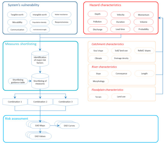
Figure 1. A proposed basic framework for risk-based flood management.
The advantage of a risk-based strategy is that it trades outcomes, which separates it from other design or decision-making methods[3] [31]. Risk-based land-use planning in a floodplain is capable of providing a non-structural means of lowering flood losses and harmonizing floodplain activities. There is a strong need for more comprehensive studies on flood vulnerability[4] [11]. Therefore, recent research indicates a risk-based approach to flood management[5][6][7][8] [10,32–34]. Risk-based management counts every aspect of risk (flood impacts) and also considers all options to manage it the most efficiently[9] [35]. In this way, risk-based assessment not only leads to an optimum flood management plan, but also creates an understanding of the mechanism generating the risk.
2. Flood Impacts
Flood impacts may include damage, disruptions, restructuring, compensation, and management expenses. There are a significant number of positive and adverse consequences of floods[10] [24]. These consequences can be classified according to the following criteria:
- Type of impact: Whether flooding is causing a positive impact or a negative
- Connection with the flood:
- Direct: Whether there was a physical connection with the flood?[11][12] [36,37]
- Indirect: In case the damage occurs spatially and temporally out of a flood event[11][13]
- Primary: Not direct, but still occurred within the floodplain
- Secondary: The impact is not within the floodplain
- Primary: Not direct, but still occurred within the floodplain
- Secondary: The impact is not within the floodplain
- Induced: Efforts to manage floods
- Capability of expression in monetary terms[14][15]
[39,40]- Tangible: Whether it can be expressed simply in currency terms
- Intangible: If the impacts have a social and/or emotional value
- Tangible: Whether it can be expressed simply in currency terms
- Intangible: If the impacts have a social and/or emotional value
Practical examples are provided in Table 1.
Table 1. Flood impact classification.
|
Tangible |
Intangible |
|||
|
Positive |
Negative |
Positive |
Negative |
||
|
Direct |
High nutrient water to crops reducing water and fertilizer costs, flushing of salt from the land’s surface |
Capital loss (houses, crops, cars, factory buildings), deposition of pollution and debris or salts |
Increased biodiversity, archaeological discoveries |
Victims, ecosystems, pollution, monuments, culture loss |
|
|
Indirect |
Primary |
Replenishing lakes and ponds for fishing production |
Production losses, income loss, theft, and robbery during an evacuation |
Groundwater recharge |
Social disruption, emotional damage |
|
Secondary |
Increase in production and sales of competitors in an outside area |
Production losses for supplier from outside the flooded area, unemployment, inflation |
Occlusion of seawater intrusion in estuaries and coastal areas, aquifer recharging of outside areas |
Transmission of vector-borne diseases to an outside area, migration |
|
|
Induced |
Increased business & production for relief & rehabilitation, insurance business |
Costs for relief aid, flood protection measures, and all management costs |
Raised patriotism & regional cooperation in relief and rehabilitation |
Evacuation stress Land-use restrictions/regulations |
|
3. Flood Risk: Definitions and Parameters
The main objective of this research is to provide a basic framework to develop a risk-based flood management strategy for a floodplain. A first task is to put together various views of what constitutes “risk” in general, and flood risk in particular. The research also discusses how flood risk evolves, what the causes of this development are, how they can be affected so as to mitigate the risks (by what points of attack and by what measures), and how these can be combined. A detailed explanation of risk-based management is carried out in order for a better understanding of the approach. In addition, for clear comprehension and to avoid ambiguity and misconceiving, the basic terms involved have been defined here. Although there is a general agreement on most of the definitions, some terms are used for different meanings by some scientists.
4. Risk Perception
The term risk has been defined and understood in many instances to have somewhat similar meanings. Emphasis has been placed on various elements when being defined by different scientists, as follows:
- Risk = hazard × vulnerability[16] [41]
- Risk = impact of hazard × elements at risk × vulnerability of elements at risk [17][18][42,43]
- Risk = hazard × vulnerability × value (of the threatened area)/preparedness[19][20][21][22][23] [44–48]
- Risk = probability × consequences[24][25] [49,50]
- Risk = hazard × consequences[26][27][28] [51–53]
Overall, the term “risk” is somehow is related with the vulnerability, hazard, impacts values, elements at risk, preparedness of the people, results or the consequences, and the chances of all of these happening (these factors have also been differently defined). Risk may be generally envisioned as “an estimate of potential consequences associated with a hazard”. The following section provides further understanding of risk, and proves how various definitions of risk are representing the same concept, just in different terms.
5. Risk Parameters
Risk-based assessment evaluates flood measurements based on potential impacts, while reducing negative impacts of floods, such as socioeconomic and environmental factors. This method provides a logical ground to shortlist and finalize flood management options. Understanding risk concepts, elaboration of the role of the river process, and societal activities should be considered during the assessment. Risk can be broadly defined as “an estimation of expected results connected to a hazard”.
|
Risk ($ year−1) = Probability (year−1) × Consequences ($) |
(1) |
Also, the risk is a function of how vulnerability interacts with hazard or vice versa.
|
Risk ($ year−1) = Hazard (m year−1) × Vulnerability ($m−1) |
(2) |
The above-stated term indicates that the hazard itself is not the only cause for risk induction. Everyday vulnerability and hazards shape trends of rising risk, which can end in a catastrophe arising from an exceptionally natural incident[29] [54]. Therefore, two independent variables are considered for risk analysis—hazard and vulnerability. In flood management, the term “hazard” indicates the occurrence of a high-water-level event with a given probability of exceedance[30] [55]. Thus, the hazard may be classified by its intensity and probability.
|
Hazard (m year−1) = Probability (P) (year−1) × Intensity (I) (m) |
(3) |
Probability can be defined as the chance of a hazard to occur that can be defined annually for a flood event. While some negative intensity features (depth, velocity, etc.) of hazards cause damage, vulnerability is the outcome of susceptibility and exposure.
|
Vulnerability ($m−1) = Susceptibility (S) (m−1) × Exposure (E) ($) |
(4) |
Where people and value currently exist in an under-threat region is known as exposure. Susceptibility is generally defined as the relative loss function[31][32] [56,57]. The ability to recognize the losses from the hazard is susceptibility. The extent of loss is based on the susceptibility of vulnerable items and life, and indeed the magnitude of hazard. In order to comprehend the role of both sides, risk in terms of vulnerability and hazard needs to be articulated, as illustrated in Equation (2). Thus, we get Equation (5) by substituting vulnerability and hazard by their components in Equation (2). Likewise, expressing probability alone will result in Equation (6).
|
Risk = [P × I] (m year −1) × [S × E] ($m −1) |
(5) |
|
Risk = P × [I × S × E] ($ year −1) |
(6) |
If the chance of the mutual interaction of vulnerability and hazard is considered separately, the consequences are definitely as a result of a hazard’s intensity, and the total exposures of assets and how much they accept the damage from the hazard (the susceptibility). It can be observed that Equation (6) is an elaborated expression of Equation (2). A graphical demonstration is shown in Figure 2 below.
Figure 2. Graphical explanation of risk into its components and demonstration equivalency of different definitions of risk (source[33]).
Graphical explanation of risk into its components and demonstration equivalency of different definitions of risk (source [18]).
6. Scheme of Measures
Flood management options can be defined as those that reduce challenges and those that enhance the individual and societal ability to cope with a flood. Typically, a mixture of methods would be the most effective management technique. There is an inversely proportional impact of probability on vulnerability. Normally, floods that occur more frequently are more adequately responded to, and therefore cause less harm. Quite rarely, (extreme) floods can cause significant harm. In areas that are located away from the river, these types of losses primarily occur. Because of more exposure and higher susceptibility, vulnerability rises as people who live far from the river do not expect a flood. The risk of occurrence primarily defines the magnitude of the protection measures initiated in a floodplain. Flood-suffering areas also implement infrastructure steps, such as floodproofing, etc. Flood interventions are highly dependent on risk factors, as well as technological, financial, and social constraints, for their efficacy and suitability.
Therefore, comparisons are made between alternatives, and evaluations are usually comparative. Therefore, the advantages and drawbacks of one alternative exist only in comparison with those of another. Identifying the potential role of one strategy in managing flood hazards includes identifying the potential roles of all other flood hazard management strategies at the same time. Compared with the best choices, the solution found through the evaluation process cannot be any better. Therefore, it is important to allow a sufficient range of options if the best choice among them is to be sought. While some guidelines have been suggested to maximize the probability of choosing the best alternative among those considered, the most effective method is to include the public in defining both important problems and potential solutions early on.
7. Assorting Suitable Measures
Detailed risk assessment of all possible flood management measures is not economically feasible. A competent professional with knowledge of the domain of flood management while using available data can discard certain flood management options without going into a deep analysis[34] [58]. Similarly, certain measures are preferable under certain prevailing conditions. For example, floodproofing of individual areas within the floodplain has been proven to be more economically feasible compared with flood protection by constructing dykes under conditions where the floodplain is not densely populated. Some measures are highly counterproductive in certain situations. One example is constructing a dyke in a mountainous area, where flood levels fluctuate more rapidly and chances of dyke failure are high. In this case, the dyke prevents the floodwaters from receding once the flood peak has passed. The selection of a suitable measure is done by considering the appraisal needs and the contribution of the measures in achieving appraisal objectives.
Different flood management options should be evaluated one by one by approximation. Developing options correctly can save time and resources. The following steps are recommended in order to develop the most suitable combination suited to appraisal needs:
- Identification of a wide range of options considering the topographical, environmental, social, and cost-effective constraints
- Screening out impractical and infeasible options
- Shortlisting options that most probably can achieve the best use of resources
- Development of a wide range of options by combining different combinations of measures
Figure 3 provides a rule-of-thumb guideline example in order to shortlist the measures under the predominant conditions of the floodplain. The data are compiled based on extensive literature review[35][36][37][38][7][39][40][41][42][43][44] [2,5,16,19,29,33,59–64] and field experts’ opinions. Plenty of case studies were observed and their preferred approaches were noted. Figure 4 is developed after detailed brainstorming sessions with field experts. This guidance is tentative and is based on a range of typical benefits, including reduced costs and additional socio-environmental benefits.
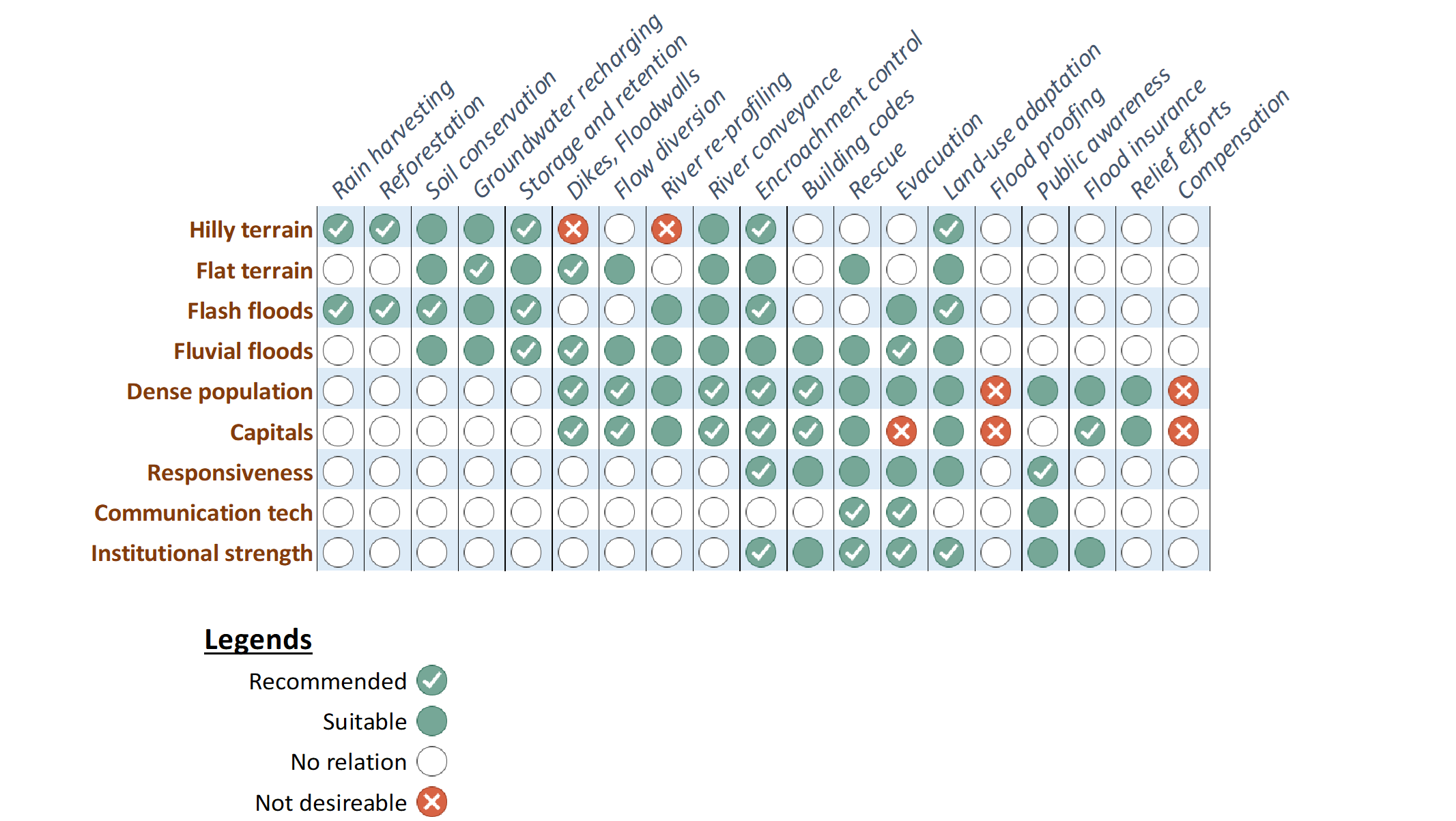
Figure 3.
A practical example of flood management option priorities about different characteristics of the floodplain.
7.1. Suitable Measures at Catchment
Catchment management can be an effective option with or without the support of other measures. Some land-use practices can increase the tendency of rapid and high peak runoff, especially if the soil surface is left bare for long periods of the year, or periods when heavy drainage is more likely[39][45] [59,65]. Not only land use, but also installing meteorological and hydrometric telemetric stations in the basin, is important for an effective flood forecast-warning system. It is important to record meteorological and hydrometric data in real-time[46] [66]. In most cases, there is ample time to identify and notify the local authorities of an oncoming significant flood event[40] [60].
Agricultural activities play a significant role in the generation of total volume and peak flow. For example, livestock above certain densities can lead to soil compaction (which increases rapid surface runoff) and the loss of water to evapotranspiration is minimized by reducing biomass, thereby increasing the runoff[47] [67]. The way the catchment’s surface is controlled by tillage will influence rapid runoff for a given land-use[48] [68]. Through evapotranspiration, trees can increase water loss and increase infiltration via their root networks, both reducing overland flow generation[49] [69]. Watershed protection steps can also be seen in watershed planning from the perspective of soil conservation, economic and agricultural aspects, and recreational concerns[50] [70].
In the case of hill torrents/flash floods, the most effective measures lie with catchment management. A sudden increase in torrent kinetic energy may occur in the high regions. Technical interventions, such as tanks and inhibitory dams, can be designed for flood interception before the floods start heading to the low regions[46] [66]. Steps taken at the catchment may help to de-synchronize the accumulation of water at points where the torrent’s kinetic energy is increased. Furthermore, forest conservation measures should be considered, as they play a significant role in the prevention of flood phenomena[46] [66].
7.2. Suitable Measures at the River
There are fewer options that can be taken at the river to interrupt the floods, such as shielding banks from erosion and increasing the conveyance of the channel[46] [66]. The rate of flow conveyance, an inverse function of the attenuation rate in the absence of tributary inflows, depends on river and floodplain roughness; by increasing river roughness, the flow tends to deepen in the river and more easily cause flooding. As floodplain flows are generally shallow, they appear to be sluggish, and so attenuation will increase[39][51] [59,71]. Excavation should be easily feasible; that is, no bedrock should be found within the diversion excavation depth. Another important consideration is that either a natural body of water should be available to dispose of the diverted water, or enough gradient should be available to drop the water back into the river without having a significant backwater effect[34] [58].
7.3. Suitable Measures at Floodplain
Densely populated and high economic growth areas have been protected by building dykes. The construction and maintenance cost of dykes can be justified for the level of protection they provide to the floodplain[52] [72]. Klijn et al.[53] [73] investigated the enhanced exposure and increased vulnerability of The Netherlands’ defense system and found that the risk was increased because of increased vulnerability. However, floodproofing or relocation can be considered if it is a small town or if there are only a few houses in the region to be covered from potential flooding. Relocation is an option only when damage is high and there is no economic reason for any other choices. Medium–low economic growth limits the deployment of costly defense systems to high-risk areas[42] [62]. In addition, in a region with a clay soil type, the construction of a dyke is not the preferred choice[34] [58]. Because of environmental concerns, a dyke is not recommended where there are wetlands or marshes in the region, because they dry out in the absence of regular recharging by natural floods[34] [58].
Water storage, artificial groundwater recharging basins, and wetlands have multiple benefits in addition to flood attenuation. Artificial groundwater recharging is one of the effective options to handle flash flooding[46] [66]. However, many considerations are required in order to implement the option. For a single location to be protected from flooding, reservoirs are not an option, unless the project can be economically justified by considering additional uses, such as hydropower generation, water supply, recreation, etc. Most essential of all, a suitable place should be available for building a reservoir[34] [58]. Farmers’ willingness to allow flooding to their land is very necessary for the option of the retention basin. Water-logging (high groundwater levels) in the region should not be serious. There should be no historical site of significance, or it should be possible to protect the site from the damage caused by managed flooding by building a dyke around it or by any other steps[34] [58].
7.4. Interconnected Suitability of Measures
Flood management measures are strongly connected, and their performance is affected when applied in combination. For example, if the majority of the watershed is barren ground, dredging should not be considered, as surface runoff would carry tons of sediment. Water-logging should not be serious, as there will be a lack of additional capacity due to increased groundwater flow into the system. Dredging is not an option if the river has a serious sedimentation problem. Preferably, the additional river capacity needed to handle damaging floods should be equal to or less than 50% of the current river capacity[34] [58].
In addition, few measures are alternative and exclusive to each other. For example, Hsieh et al. [41][61] evaluated three mitigation steps for flood-prone lowlands with a high population density along the Keelung River in Taiwan, including dykes, a drainage channel, and a storage reservoir. A diversion channel was proven to be more feasible than the other two flood mitigation options because of the high population and economic activity concentration in the floodplain. Where budgets are too poor to support defenses, successful, controlled realignment, or planned destruction will occur, with habitat recreation where necessary[42] [62]. Dixon et al.[39] [59] found that for smaller drainage basins, usually less than 100 km2, the restoration of the river channel morphology and floodplain forest can be the basis of flood risk mitigation.
8. Software Tools
Several tools/software programs have been developed to carry out flood simulations in order to estimate flood damage/risk. The methodology/approaches of these tools vary at a large scale, extending from hydrodynamic modeling to statistical, artificial intelligence-based, and even stage-damage or discharge damage empirical models. The majority of tools are hydrodynamic models that simulate the flood wave in 1D, 2D, and 3D[54][55] [74,75]. These include models that have compatibility with geographic information systems (GIS)[56] [76]. A few tools have additional extensions/modules to perform statistical analysis and damage calculations as well. The inclusion of GIS capabilities has become more popular in recent years in hydrodynamic models. However, damage estimation tools recognize GIS capabilities on a larger scale. Most common software takes basic hydrologic, hydraulic, and topographical inputs to simulate flooding, while others estimate the flood damage considering the depth of flood and land-uses parameters in an empirical way. Table 2 lists a few software tools, along with their capability for GIS and country of origin.
Table 2.
Popular software tools, their compatibility to geographic information systems (GIS), and their country of origin.
|
Software |
GIS-based |
Country |
|
ANUFLOOD |
No |
Australia |
|
ESTDAM |
No |
UK |
|
FAT |
Yes |
Czech Republic |
|
FDAM |
Yes |
Japan |
|
FLODSIM |
No |
South Africa |
|
FloodAUS |
Yes |
Australia |
|
HAZUS - MH |
Yes |
USA |
|
HEC-FDA |
No |
USA |
|
HIS-SSM |
Yes |
Netherlands |
|
HWSCalc |
No |
Germany |
|
TEWA |
Yes |
South Africa |
|
MDSF |
Yes |
UK |
9. Practical Examples
A few case studies are already being carried out under the defined framework. However, there are some good examples that can explain parts of the framework with real examples of flood management. Klijn, F. et al.[53] [73] explained various concepts of risk-based flood management and provided initial suggestions to approach towards risk reduction. Two case studies have been referred to in order to demonstrate flood adaptations (vulnerability adjustments). Jukrkorn, N.[57] [77] performed an ex-post analysis of a 2011 flood in central Thailand, and discussed the selection of various flood measures and their integration to a well-connected system. Agent-based modeling was performed by Yared, A. A. et al.[58] [78], where they studied the impact of hazard reduction and vulnerability control in Sint Maarten. Another case study conducted by Rogger, M. et al. [59][79] explained land use effects in catchment on flood management with supporting options. Serre, D. et al.[60] [80] explained the effectiveness of structural and non-structural measures regarding a few historic floods in Europe and the USA.