Your browser does not fully support modern features. Please upgrade for a smoother experience.
Please note this is a comparison between Version 1 by Norhan Bayomi and Version 3 by Jessie Wu.
The proliferation of drone technologies has revealed new frontiers for climate change research and analysis in urban environments. Drones, also known as unmanned aerial vehicles (UAVs), provide scientists with unprecedented abilities to collect detailed spatial and temporal data about the built environment, enabling for more robust studies on the impacts of climate change on cities. Whereas satellite imagery was previously allowed for large-scale data accessibility, drones at present facilitate close-range data capture, monitoring, and mapping at new scales and from multiple angles.
- UAVs
- AI
- climate change research
1. Unmanned Aerial VehicleVs in Climate Change Research
The potential of unmanned aerial vehicles (UAVs) in climate change research emerged in the early 2000s as miniaturized sensors, global positioning systems (GPS) GPS navigation, and battery technology enabled lightweight remote sensing platforms. NASA scientists first demonstrated the utility of small fixed-wing UAVs for studying atmospheric dynamics, composition, and thermodynamics in the early 2000s [1][124]. This pioneering work sparked the recognition that UAVs could fill in the gaps in climate observation networks, given their flexibility, cost-effectiveness, and ability to sample hazardous environments.
UAVs were first deployed for humanitarian action in the early 2000s by nonprofit organizations seeking aerial damage assessments after disasters when manned aircraft flights were limited. In 2004, humanitarian groups operated small UAVs to survey post-hurricane flooding outcomes and assess infrastructure damage from the Haitian earthquake [2][125]. These initial efforts highlighted the potential for UAVs to support disaster relief by providing rapid emergency mapping when access was constrained. The early demonstrations of UAVs for post-disaster mapping and relief accelerated into more operational deployments in the early 2010s. By 2015, UNICEF also tested UAVs in Malawi and the Dominican Republic for transporting medical samples, vaccines, and other cargo as part of the agency’s UAV evaluation initiative [3][126]. This was followed by the launch of the Kazakhstan Drone Corridor as a testing ground for drone delivery systems [4][127]. These initiatives helped pave the way for more robust and ethical frameworks for using UAVs for humanitarian aid and crisis responses. Figure 1 illustrates UAVs’ innovation timeline and integration in humanitarian research since the early 2000s.
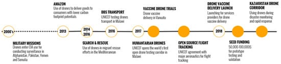
Figure 1.
UAV innovation timeline and integration with humanitarian action research.
In climate change research, UAVs are emerging as a valuable tool for monitoring environmental impacts through flexible high-resolution aerial mapping, and have been deployed in multiple climate change research domains, as shown in Figure 2, as exemplified by a case study conducted in the Yukon–Kuskokwim Delta region of Alaska [5][128]. The researchers implemented multi-sensor-equipped UAVs to autonomously survey and map the challenging terrain, acquiring high-resolution visible, multispectral, and thermal infrared images. The versatility and customizability of the UAV platforms allowed the research team to tailor the systems to the specific scientific requirements of evaluating the landscape changes related to permafrost degradation. Geospatial data analytics generated from the UAV-acquired remote sensing datasets provided the efficient monitoring of the impacts of global warming on critical cultural and ecological heritage sites in the Arctic tundra ecosystem. The study demonstrated the emerging potential of UAV remote sensing to enable rapid, cost-effective, and frequent landscape characterizations, furthering the capabilities for climate change assessment and adaptation strategies.
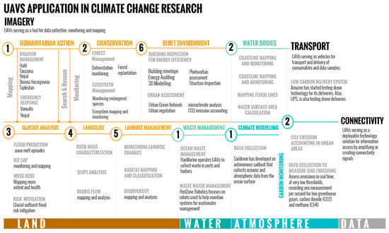
Figure 2.
Summary of UAV applications in climate change research.
Recent urban expansion coupled with the impacts of climate change have created a need for enhanced methods of monitoring and managing sustainable city developments, as investigated by Djimantoro and Suhardjanto [6][129]. The researchers experimentally implemented UAVs equipped with photogrammetric imaging payloads to autonomously survey and reconstruct 3D digital surface models of building infrastructures at sub-meter resolutions. Compared to the existing means of geospatial data acquisition, UAV mapping demonstrated a greater flexibility, higher cost-efficiency, improved time-effectiveness, and increased safety versus conventional manned aerial mapping. The study results highlighted the emerging potential of UAVs to provide city planning departments with rapid, up-to-date 3D-mapping capabilities to better control urban development amidst the constraints of limited governmental budgets and personnel. The findings emphasize the importance of developing UAV and photogrammetric innovations to support frequent, precise 3D urban infrastructure mapping to inform data-driven policies for sustainable city growth and resilience.
Additionally, UAVs with multispectral imagery have been used to assess losses as a result of herbicide-induced stress by monitoring decreased vegetation greenness as indicative of stress [7][130]. Furthermore, UAVs have found numerous applications in Antarctic environmental research. By capturing detailed imagery and data, UAVs provide valuable insights into the impacts of climate change on Antarctic ecosystems, including changes in vegetation distribution, ice dynamics, and wildlife habitats [8][131]. UAVs have been used to monitor erosion and sediment control practices [1][124]. In addition, UAVs have been deployed to assist in mapping shrubland structural attributes, monitoring grassland ecosystems, and studying cryospheric components, such as glaciers and ice shelves [9][132]. Using UAVs in Antarctic environmental research has enhanced data collection capabilities, improved spatial resolution, and the enabled efficient monitoring and assessment of the unique and fragile Antarctic environment.
UAVs have proven useful for mapping the erosion and accretion patterns in coastal environments vulnerable to sea-level rise. A study in Ghana combined LiDAR elevation data and visual imagery to analyze shoreline changes from extreme storms [10][133]. UAVs also enable the rapid assessment of coastal flooding extents during storm surges and tide cycles using visual cameras or thermal sensors to identify inundated areas [11][134]. These high-resolution shoreline data help improve coastal flood modeling and predictions. In the domain of emission monitoring, researchers have used UAV-based methane detection and quantification to track wetland emissions and offshore gas seeps [12][135]. Moreover, multiple studies have utilized UAVs to measure carbon dioxide concentrations and fluxes in complex urban environments [13][14][15][136,137,138]. Such flexible aerial sampling can improve emissions inventories and our understanding of climate feedback. Furthermore, UAVs equipped with gas sensors have been used to monitor and evaluate the environmental impacts of specific industries, such as mining operations. These UAV-based monitoring systems enable the measurement of greenhouse gases and particulate matter, providing insights into the emissions generated by mining activities and their potential effects on the surrounding environment [16][139].
UAVs are emerging as a critical tool for wildfire agencies to map active blazes and their progression in real time. Equipped with visual and infrared cameras, UAVs flown over fires provide continuous video footage and imagery to track the leading edge of the fire perimeter [17][140]. This helps personnel on the ground identify threatening spread directions and allocate resources effectively. Thermal sensors on UAVs enable penetrating smoke to pinpoint hotspots and flare-ups [18][141]. Immediate aerial views of unfolding wildfires aid the tactical planning and maintenance of responder safety.
In climate hazard assessments, UAVs provide a versatile tool for studying landslide hazards and terrain instability exacerbated by climate change. High-resolution orthomosaic and digital surface model reconstructions from aerial photogrammetry enable the detection and measurement of ground deformations indicative of landslide activity [19][20][142,143]. Furthermore, UAVs have been proven to be effective in mapping landslides in highly dense vegetation areas [21][144]. Combining LiDAR scans and visual data allows mapping discontinuities in rock masses to model failure potentials [22][145]. UAVs contribute to the characterization of rock masses by extracting the geometric properties of rock mass discontinuities, such as orientation and spacing, providing insights into the stability conditions of rock slopes [23][146]. Recently, a considerable amount of research has deployed UAVs with infrared thermography, further enhancing the monitoring capabilities, identifying thermal anomalies, assessing rock mass conditions in complex environments, and identifying slope hydrology dynamics influencing instability [24][25][147,148]. For characterizing debris flows, UAVs can capture high-resolution images and generate digital terrain models (DTMs) that identify and map debris flow paths, help estimate deposited volumes, and quantify torrent evolution [26][149].
UAVs have also been deployed for climate modeling and air-quality monitoring, providing access to more granular data. Combining microclimate sensors and air-quality instruments allows UAVs to relate local weather, pollution, and environmental factors to community health. For instance, a study in California gathered hyper-local air-quality data to model pollution exposure risks and guide the policies for protecting vulnerable populations. UAVs can also be integrated with advanced technologies, such as artificial intelligence and computer vision, to analyze and interpret the collected data, which can identify pollution hotspots, predict air-quality trends, and develop early warning systems for potential health risks. As climate change leads to more frequent extreme heat and air pollution episodes, UAV sensor networks can enable real-time monitoring to issue health warnings.
2. Urban Challenges and Unmanned Aerial VehicleVs Opportunities
As previously mentioned, climate change places a lot of pressure on the built environment with escalating impacts, ranging from climate hazards, such as floods, severe storms, and heatwaves, to infrastructure vulnerabilities. UAVs have emerged as a transformative technology to meet cities’ sustainability challenges. With flexible deployment and data capture at neighborhood scales, UAVs enable cities to monitor their built environments and climate risks in real time, while helping diagnose and evaluate the solutions. The rich spatial and temporal perspectives offered by UAVs have become integral across diverse urban climate research domains, unlocking actionable intelligence needed by cities on the frontlines of climate disruption. UAVs are indispensable tools for developing resilient and sustainable cities. They provide critical data that enable informed decision making, efficient resource management, and proactive measures to address climate change challenges. As urbanization continues to occur, leveraging drone technology is essential in creating cities that are not only better prepared for climate-related threats, but also more sustainable and livable for their residents. Their capacity to furnish critical insights through drone-based climate change research is pivotal for enhancing urban planning, infrastructure design, and policy making. The precision and real-time monitoring capabilities of drones, equipped with advanced sensors, facilitate the acquisition of high-quality data on climate parameters, pollution levels, and environmental factors. This high-resolution data accessibility is critical to empower decision makers with the necessary information to navigate climate challenges. In a world marked by increasing urbanization and environmental challenges, UAVs emerge as a cornerstone for crafting cities that are both well-prepared for climate-induced threats and genuinely sustainable for their inhabitants.
- A.
-
Urban Microclimate Assessment
One of the main domains where UAVs play an integral role in climate change research in cities is mapping and analyzing localized phenomena, such as urban heat islands. UAVs with thermal infrared cameras can rapidly map fine-scale urban surface temperature variations to delineate heat islands and cooler areas linked to land cover. Flights at altitudes below 300 meters provide pixel resolutions down to 10–50 cm, capturing microclimate gradients within neighborhoods. A study by Naughton [27][68] leveraged drone thermal cameras to map micro-scale temperature variations down to individual city blocks in Texas, USA. By combining these UAV thermal data with land-cover information, the researchers identified localized hotspots correlated with limited greenery, ineffective roofs, and urban materials. This granular UHI quantification and diagnosis assisted targeted interventions in the built environment to mitigate heat risks. Moreover, UAV thermal data have been used to correlate temperatures with vegetation, impervious surfaces, building density, and road types across cities coupled with satellite imagery to provide a comprehensive assessment of the dynamics of urban microclimates [28][150]. This helps model microclimate interactions with the built environment and identify the localized areas most vulnerable to extreme heat.
In addition to thermal imaging applications, UAVs have been deployed to collect high-resolution aerial imagery and LiDAR data to construct detailed 3D models of urban morphology. Photogrammetry processing generates point clouds, mesh models, and orthomosaic classifying features, such as buildings, roads, and vegetation [29][2]. LiDAR complements the visual data with urban elevation mapping [30][151]. Classified 3D models enable the analysis of urban geometry, including sky view factors, building heights, and canyon orientations influencing solar exposure and heat retention [31][152]. By correlating land-surface temperatures with land-cover types derived from UAV-based 3D models, the researchers can gain insights into the factors contributing to urban heat island formations and develop strategies for mitigating their effects [32][153]. Furthermore, a study by Yang et al. [33][154] examined the spatial and temporal variations of heat islands in Zhengzhou, China, considering the influence of urbanization and urban forestry. The drone imagery helped assess the effectiveness of urban forest construction in mitigating the urban heat island effect.
- B.
-
Building Envelope Performance
UAVs empowered with infrared sensors have emerged as an essential tool for building envelope inspections and building energy audits. One major application is using thermographic cameras mounted on drones to detect heat leaks, air infiltration, exfiltration, and insulation deficiencies in roofs and facades. UAVs can be easily deployed to survey every side of a building’s structure from optimal proximity compared to the ground-based thermography providing more accurate insights into the thermal performance of building envelopes [34][155]. A study by Rathinam et al. [35][156] presented a comprehensive exploration of the utilization of UAVs for real-time structure detection and tracking, focusing on linear structures, such as roads, highways, and canals, based on the visual feedback. The research tackled two critical components of this challenge: vision-based structure detection and controlling the UAV to follow the structure accurately. The insights provided by this rpapesearch hr have broad applications in different domains. For instance, in infrastructure monitoring, the paper highlights the potential for autonomous UAVs to inspect and monitor structures, such as pipelines, roads, and power grids. This capability can enhance safety and reduce the operational costs. The paper also emphasizes the significance of this technology in disaster responses. Following events, such as earthquakes or natural disasters, where infrastructures can be severely affected, autonomous UAVs can rapidly assess the damage and provide real-time visual feedback, aiding in efficient recovery efforts. Additionally, the ability to autonomously monitor the critical infrastructure can have implications for homeland security, ensuring the integrity of key assets, such as bridges, roads, railways, and power transmission corridors
Producing orthorectified thermal maps reveals the location and severity of envelope flaws causing energy waste, which can be addressed through suitable retrofit strategies. A study by Falorca and Lanzinha [36][157] explored the use of drones for facade inspections and building envelope pathology diagnoses. Drone technology proved to be an effective and promising alternative methodology for supporting the technical inspection and diagnosis of building envelope pathologies. UAVs also enable low-cost frequent inspections to monitor repairs or catch new leaks as they emerge post-occupancy or post-retrofit. Moreover, UAVs can help facilitate rapid scanning to map cracking and spalling that undermine structural integrity. The photogrammetry processing of visual imagery can construct 3D point clouds capable of millimeter-scale crack detections [37][158]. Utilizing infrared sensors also highlights areas of moisture intrusion within wall systems signaled by temperature differentials [38][119]. A study by Alzarrad et al. [39][159] presented a promising approach to automating sloped roof inspections using UAVs and deep learning. It highlighted the significance of such technology in enhancing efficiency, reducing safety risks, and providing accurate assessments of roof conditions. While acknowledging the limitation of a small dataset, the paper suggested that, with more data, the model’s accuracy could be further improved. Overall, this researchtudy contributed to the advancement of automated inspection techniques, paving the way for more efficient and safer practices in the construction and insurance industries.
Detailed UAV-based envelope inspections enable proactive maintenance to avoid expensive repairs and enhance resilience to climate impacts. In addition, hyperspectral data can detect moisture content and vegetation health in green roofs [40][160]. Photogrammetry models produced from UAV data help quantify surface buckling, blistering, and deformation over large areas. For a moisture intrusion diagnosis, combining thermal and visible imagery allows a precise inspection. Thermal sensors lack a visual context, while moisture below surfaces remains invisible in visible bands. However, fused thermal–visible data confirm and localize the anomalous heat signatures related to water damage [41][161]. UAVs also enable safer roof inspections versus human-based auditing and inspections, which provides a safer setting for building envelope inspections and, as a result, reduces the time and cost spent on traditional manual envelope inspections.
- C.
-
Inspection and Monitoring of Urban Infrastructures
UAVs play a significant role in urban infrastructure assessments as they can rapidly map infrastructure conditions at high resolutions to identify the risks and needs before failures occur. For example, UAVs enable the detailed inspection of bridges, roads, railways, and waterways to detect corrosion, cracks, scour, or structural issues exacerbated by escalating extreme weather [35][42][156,162]. Multi-angle imagery provides a comprehensive documentation of asset states across otherwise challenging to inspect surfaces. UAVs similarly facilitate assessing power grid assets, such as above-ground transmission towers and lines, for weathering and vegetation overgrowth under altered climate conditions [43][36]. Integrating electromechanical sensors on drones enables electromagnetic field measurements around components to detect developing faults. For pipeline rights of way, LiDAR and hyperspectral UAV data help maintain vegetation clearing for asset access and safety, and can thus provide further rapid damage assessments of utilities after severe climate events.
UAVs are useful for periodic inspections and their automated flight capabilities enable the continuous monitoring of infrastructure conditions to identify issues as they emerge. For example, UAVs equipped with thermal and visible cameras can autonomously conduct weekly flights over bridges to track the progression of fatigue cracks or corrosion damage on concrete and steel elements [44][163]. This frequent imaging creates time-series data to identify when deterioration exceeds the allowable thresholds, triggering needed repairs. UAVs similarly facilitate the regular assessment of road surfaces, rail tracks, buried pipelines, and canal levees to quantify incremental weathering, subsidence, or erosion [45][164]. Operators can implement more frequent inspections of assets identified as higher priority or already in degraded states. Researchers have explored various approaches for UAV-based traffic monitoring, as surveyed in “A Survey of Unmanned Aerial Vehicles (UAV) for Traffic Surveillance” [46][165]. With their mobility and sensor integration, UAVs offer new opportunities to continuously assess road conditions and traffic flows beyond what static systems allow. The data timelines provided by repeat UAV flights can assist in modeling climate impact accumulation rates and target retrofits to extend asset lifetimes. Continuous monitoring also supports the evaluation of repair durability and new materials under actual field conditions. By enabling a low-cost persistent oversight, UAVs are a pivotal tool for adaptive infrastructure management amidst intensifying climate stresses.
- D.
-
Assessment of Climate Hazard Impacts and Emergency Response Coordination
In the domain of climate hazard assessments, UAVs are emerging as an invaluable tool for rapidly assessing infrastructure damage and the environmental impacts following climate-related disasters. Following floods, storms, wildfires, and other events, UAVs provide rapid aerial-based assessments when manual assessments are restricted due to safety concerns [47][48][166,167]. Visible and multispectral UAV sensors supply detailed visual evidence of the destruction critical for compiling robust post-disaster reports [49][50][168,169]. UAVs also enable the scoping of disaster extents across neighborhoods and cities to allocate a response capacity. Another application is coordinating emergency response logistics using UAVs as communication relays and cargo transporters. UAVs can provide wireless connectivity to areas with destroyed infrastructures and monitor personnel deployments [51][170]. Using thermal and multispectral sensors, UAVs help locate victims during search-and-rescue operations, especially in inaccessible urban areas [52][171]. For cargo delivery, UAVs assist in transporting critical supplies, such as medical samples, water testing kits, radio equipment, and batteries, when ground transport is hindered post-disaster [53][172].
Furthermore, UAVs can be utilized to assess flood events and their impacts on urban areas. By collecting high-resolution images and mapping the extent of flooding, UAVs provide valuable information for estimating direct tangible losses to residential properties and assessing the overall impact of floods. These data can support emergency response coordination, aid in resource allocation, and inform decision-making processes for future flood mitigation and adaptation measures [54][173]. Another critical value of deploying UAVs is providing real-time information on the behavior and impacts of natural hazards, such as wildfires, landslides, and coastal erosion. These data are crucial for emergency response coordination, enabling authorities to make informed decisions and perform actions in a timely manner to protect communities and critical infrastructure [55][174]. UAVs also aid impact attribution studies by providing baseline mapping to compare with post-disaster conditions. As the climate risks increase, UAVs are becoming integral to assessing hazards, coordinating responses, and building climate resilience.
3. Data Collection and Processing Platforms
As outlined above, UAVs provide ample opportunities for a more accurate and rapid monitoring and assessment of numerous climate change challenges in the built environment. The existing literature reveals various frameworks to structure UAV operations and data collection workflows. Khan et al. [56][175] proposed a comprehensive multi-stage model for UAV-based sensing encompassing: (i) defining the operational scope and objectives, (ii) flight planning and route design, (iii) UAV deployment for planned data acquisition, (iv) sensor data gathering, (v) the processing and analysis of the collected data, and (vi) interpretation and communication of analysis results. Similar staged methodologies aim to provide end-to-end guidance for executing UAV remote sensing missions from initial planning through data extraction and interpretation methods. A systematic workflow is critical for effectively leveraging UAV capabilities across diverse monitoring and inspection applications. This multistep framework can be aggregated into three primary stages: (1) mission planning, (2) data acquisition, and (3) data output or processing. Figure 3 illustrates the key parameters associated with each stage and the average time spent.
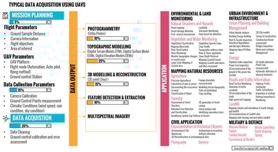
Figure 3.
Typical data acquisition and processing frameworks and output needs for different UAV application categories.
The mission planning step involves flight planning based on the sensing objectives. Key mission parameters, such as altitude, speed, overlap, and routing, are determined to ensure the desired area is covered at an appropriate resolution. This frames key mission parameters, such as sensor payload, flight duration, altitudes, and required resolution. Sensor payload selection is also critical to gather relevant information, whether RGB, multispectral, thermal, or LiDAR systems. With the flight mapped out, the UAV is deployed to autonomously follow the programmed path and trigger sensor recording [57][176]. After mission scoping, the flight planning process includes the design of detailed flight plans specifying automated flight routes, sensor triggering locations, altitudes, and speed. The flight parameters ensure full coverage at the desired resolutions, orientations, and overlap percentages between each captured image. Additionally, mission planning includes data collection parameters, such as sensor calibrations and ground control point (GCP) design. The mission planning time ranges from hours to weeks depending on the mission scale and complexity, representing around 5% of the overall data acquisition process [57][176]. Thorough planning is crucial for successful data acquisition.
The data acquisition stage encompasses UAV deployment, in-field pre-flight checks, data capture flights, recording sensor data, and calibration of GCPs. The UAV-certified pilot operates UAVs according to the mission plan. Test flights validate the aircraft performance before conducting the full flights. The UAV then autonomously navigates the planned routes using GPS, while recording imagery, video, LiDAR, or other sensor data. The total flight time depends on the sampling scale, from less than an hour for a small site to days for large areas. Sensor and telemetry data are retrieved post-flight for cleaning and processing, which is a process that can take up to 20% of the total process time.
In the data processing stage, the collected aerial data enter processing workflows to generate analysis-ready outputs. As shown in Figure 3, the processing steps vary by data type, but often involve photogrammetry, geospatial referencing, 3D modeling, topography modeling, feature detection and classification, and/or index calculation. For example, overlapping UAV images are stitched into orthomosaic maps and digital surface models through structure-from-motion algorithms. LiDAR point clouds also undergo classification and terrain modeling. Specialized software streamlines the processing; however, a skilled analysis is required to ensure the data quality. The results are interpreted to derive actionable insights based on the mission objectives and different application needs, as shown in Figure 3.
The proliferation of UAV-based aerial mapping sparked the development of specialized photogrammetry software to process the captured imagery into 3D reconstructions, point clouds, and orthomosaic maps. As UAV adoption expands across sectors ranging from construction to conservation, selecting the appropriate data processing workflow is pivotal to efficiently transforming raw sensor data into actionable ideas. A range of photogrammetry solutions exists at present, ranging from user-friendly commercial packages designed for simplified mapping workflows to open-source options offering advanced customizations, as shown in Figure 4. Cloud computing has also created new web-based processing capabilities. Determining the optimal solutions requires aligning processing capabilities with program needs and resources. However, as sensors and airframes advance, the continued evolution of computation power and algorithms will further unleash the great potential of UAV-derived data across applications.
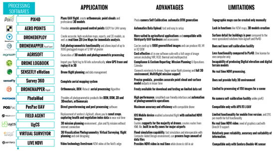
Popular commercial platforms include Pix4D, DroneDeploy, PrecisionMapper, and ArcGIS Drone2Map for general mapping needs [61][1]. These streamline workflows for common applications, such as agriculture, surveys, and inspections. Photogrammetry-focused, open-source options, such as OpenDroneMap, provide more flexibility for advanced users. Some sensor manufacturers also offer specialized processing suited to visual, thermal, LiDAR, or spectral data, as illustrated in the review provided in Figure 4.
Cloud-based processing through web services offered by industry leaders, such as Pix4D and DroneDeploy, allows rapid analysis without local computing resources [29][62][2,46]. However, cloud processing incurs ongoing subscription fees versus one-time software purchases. For projects dealing with sensitive data, local processing may be preferred or required to ensure security and prevent external data storage [63][40]. However, this requires an investment in high-performance workstations for intensive computation. Selecting optimal processing platforms depends on weighing factors, such as usage costs, processing times, data security needs, analysis requirements, and team experience level. For most inspection and mapping applications, user-friendly commercial photogrammetry suites require minimal training while providing speed, scalability, and robust outputs [58][64][24,177]. Open-source tools better suit research needs for a customized analysis, such as environmental monitoring applications and climate change research. Cloud platforms offer convenience, but may lack security; however, weighing these tradeoffs is important to match processing solutions to application goals.