Your browser does not fully support modern features. Please upgrade for a smoother experience.
Please note this is a comparison between Version 1 by Thorsten Uthmeier and Version 3 by Jessie Wu.
Both the nature and the scope of fire use by Neanderthals in Europe are often debated, as some scholars advocate limited use, without the capability to produce fire at will and with full reliance on natural fire occurrences, while others suggest advanced use, including fire-production knowledge and the application of pyrotechnologies.
- Neanderthals
- fire use
- heat treatment
- lithics
- Bavaria
- Middle Paleolithic
1. Introduction
Of special interest in this debate is the necessity, or lack thereof, of control over fire in northern latitudes, where harsher conditions occurred. While indeed considered important for coping with cold climatic conditions, the earliest sites in such regions currently lack evidence of fire use (e.g., [1][2][9,10]), with the first evidence of fire use dated to 400 kya onwards [3][8].
On the other hand, there are suggestions for the anthropogenic use of fire far earlier than this date in Africa. In Wonderwerk Cave (South Africa), for example, it was suggested, based on the identification of an ash layer and charred bones, that early humans were using fire for cooking already 1 mya [4][11]. There are other suggestions of fire evidence in Africa concerning Chesowanja [5][12] and Koobi Fora at site FxJj 20 [6][7][13,14], both of which are in Kenya, dated to ~1.5–1.6 mya. In Swartkrans (South Africa), fire use by early humans is implied based on the presence of burnt bones dated to ~1.0–0.6 mya [8][9][15,16]. Yet, none of these cases provide direct evidence for the involvement of humans in the production or exploitation of these fires [3][8].
Outside Africa, early cases of human use of fire are known from Gesher Benot Ya’aqov (Israel) [10][11][12][17,18,19] and Cueva Negra (Spain) [13][20], both dated to ~780 kya. However, both cases are followed by a long time gap in which no fire use is currently known until around 400 kya, with the identification of fire at Qesem Cave (Israel) [14][21] in the Levant and Beeches Pit (England) [15][22] in Europe. Starting from this point, fire becomes more evident in the European and Levantine archaeological records [3][16][8,23].
Roebroeks and Villa [3][8] argue that Neanderthals had advanced fire-related capabilities, including the ability to produce fire at will, preserve it and transport it. Moreover, several studies demonstrate the application of pyrotechnology by Neanderthals for the production of composite tools (e.g., [17][18][5,6]), implying advanced technological knowledge among Neanderthals (however, see [19][24]). Based on this, Roebroeks and Villa [3][8] suggest that the nature of fire use among Neanderthals resembles that of Upper Paleolithic societies.
Contrary to this, Sandgathe et al. [20][21][3,4] suggest, based on the analysis of the stratigraphy from two Middle Paleolithic sites in France, Pech de l’Azé IV and Roc de Marsal, that well-preserved hearths can be found during periods of warm climatic conditions. Conversely, during periods of cold climatic conditions, evidence of fire becomes rare. They further argue that, while late Middle Paleolithic Neanderthals were indeed capable of using fire, at least some Neanderthals were unable to produce fire and therefore relied exclusively on natural fire occurrences. The link between warm climatic periods and fire use among Neanderthal populations in Europe is further advocated by Abdolahzadeh et al. [22][1] based on data collected from the Middle Paleolithic sites Abric Romani (Spain), Abri du Maras (southeast France), Kulna (Czech Republic) and Sesselfelsgrotte (Germany).
To further contribute to this ongoing debate, reswearchers present the results of a lithic analysis classifying flint artifacts from the late Neanderthal site Sesselfelsgrotte (Germany). ResearchersWe analyze flint artifacts found in the lower-layer complex and G-layer complex of the site, evaluating their possible exposure to fire via examining for macroscopic traits associated with exposure of flint to fire (see details below). Based on these traits, researcherswe divide the artifacts into three groups: unburnt, burnt (i.e., demonstrating unmonitored exposure to fire), and possibly intentionally heated (i.e., showing alterations which are associated with intentional heat treatment, but not alterations which are associated with thermal damage). The collected data are used to establish the frequency of fire in both complexes as well as the possible application of intentional heat treatment of flint. ResearchersWe then discuss the implications of these results for the understanding of fire use by late Neanderthals and their cognitive and technological capabilities in comparison with early modern humans.
2. The Site of Sesselfelsgrotte
Sesselfelsgrotte (Figure 1) is a Paleolithic rock shelter located in the valley of the lower Altmühl River (Bavaria), a tributary of the Danube, in southwest Germany. It was excavated by Gisela Freund from 1964 to 1977 and in 1981 [23][25]. About seven meters of sedimentary deposits were excavated [23][25]. The layers are mainly composed of limestone debris from the roof of the shelter and from the slope above the cave. The small rock shelter yielded a unique sequence of 22 Middle Paleolithic and several Upper Paleolithic occupations [23][24][25,26]. The lower-layer complex was occupied during MIS 5c to MIS 5a under moderate climatic conditions and yielded eight Mousterian assemblages, while the G-layer complex was deposited under the cool climatic conditions of MIS 3. The two stratigraphic complexes are separated by archaeologically sterile layers correlating to the cold and arid period of MIS 4. The onset of cold climatic conditions is indicated by the occurrence of mammoths in the uppermost part of the lower-layer complex (Layer M1 and M2: [25][27], close to the interface with the first glacial maximum of the Weichselian glaciation (MIS 4).
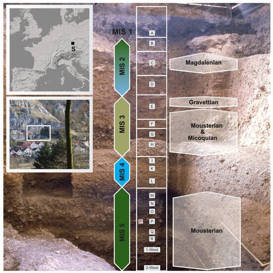
Figure 1. Location of the site (insert on the top left), view from South to the Jurassic limestone formation of the Sesselfelsgrotte with Sesselfelsgrotte in the center (white square in the insert on the left), and view into the section (with labels indicating geological layers of the Eastern profile) (photo: FAU Erlangen–Nürnberg).
The upper G-layer complex (which includes layers I, H, G5, G4, G4a, G3, G2 and G1) consists of a series of archaeological horizons containing approximately 85,000 lithic artifacts along with abundant faunal remains, consisting mainly of mammoth, reindeer, and horse remains [24][26]. The identification of the layers, including those which have yielded archaeological materials, was based on macroscopic sedimentological attributes observed during the excavations, such as the size and angularity of gelifraction debris, as well as the grain size of the sediment matrix and its color. The Label “G4a” indicates that, based on the criteria listed below, this layer was recognized in newly excavated parts of the site after the identification of G5. The archaeological finds are assigned to 13 assemblages (G-A01 to G-A13), all of which are classified as Mousterian or Micoquian [26][27][28,29]. Radiocarbon dating of charcoal and bone has yielded conventional (i.e., uncalibrated) ages of between ~48 ka BP (unit G4a/5) and ~40 ka BP (unit G2), with most of the Micoquian assemblages dating to 48–47 ka BP [27][29]. The chronological position of the G-layer complex being in an early part of MIS 3 is supported by TL dating on burnt flints, which gave a mean TL age (N = 4) of 56.0 ± 4.7 ka [27][28][29,30]. Several archaeological horizons of the G-layer complex represent living floors (i.e., layers G4 and G2), as indicated by evident features such as fireplaces [24][26].
The lower-layer complex consists of eight archaeological levels (3-West to M) and has yielded a total of 10,000 lithic artifacts (assemblages A01 to A08), all belonging to Mousterian production [29][31]. A mean TL age (N = 7) of 73.2 ± 11.7 ka for layer M [28][30] supports the assignment of the lower-layer complex to MIS 5. This chronological model is in accordance with a correlation of the overlying, archaeologically sterile deposits of units L and K, which separate the Lower-Levels complex from the G-layer complex, with MIS 4 (~71 ka) [27][29].
Human remains found at the site include the remains of immature Neanderthal individuals [30][31][32,33]. These include two deciduous teeth from Layers G2 and M2, which seem to correspond to 12-year-old children, and 12 limb bones. Additionally, rwesearchers found the ribs of a fetus or a neonate (Sesselfelsgrotte 1) in Layer G5. It has been proposed that the remains of the fetus/neonate may reflect an intentional burial [31][33].
3. On the Integrity of the Stratigraphic Units
The entire Sesselfelsgrotte sequence is mainly composed of local sediments and mostly includes limestone debris from the slope above the shelter and from the roof of the shelter. Occasionally, sedimentation was accompanied by humic and anthropogenic components. There was one large exception, and rwesearchers discovered exogenous loess deposited during the last glacial maximum. The whole sequence shows a steady accumulation of sediments on top of layer E, with only one dramatic erosion event that has been recognized [23][32][25,34].
In the lower-layer complex, traces of human activity have been found in spots within sediment lenses limited to parts of the available horizontal surface [29][31]. Moreover, lithic artefacts, charcoal, and faunal remains, objects corresponding to one and the same human occupation stage, span some vertical distance, thus bracketing several sedimentary units [25][33][34][27,35,36]. With sedimentary units widely undisturbed, such observations indicate natural sedimentation, occurring very quickly, in parallel with human occupation. Human activities were limited to the exterior part of the present shelter, before the erosion of the previous dripline diminished the interior of the shelter to its present size [29][31]. The lower-layer complex consequently became sealed by more than half a meter of angular limestone debris, completely devoid of any traces of human activity, and rich in small animal bones, indicating that the cave was inhabited by owls [35][36][37][37,38,39]. It is currently correlated with the first maximum of the last glacial period (MIS 4) [27][28][29,30]. The debris layers, called L and K layers, horizontally cover the whole surface of the shelter, with no visible interruption on top of the lower-layer complex, and are continuously covered by the G-layer complex [26][28].
The artifact-bearing G-layer complex is clearly marked by two darkly colored horizons that cover the entire surface of the shelter. These are called the G4 layer and the G2 layer [23][25]. Much of those sediments display anthropogenic impact and show, or are altered by, traces of fire (cf. [33][35]). At the time of G4 and G2 accumulation, the sedimentation rate was low, thus allowing for the preservation of such occupation surfaces [26][28]. Layers G4 and G2 accordingly served the archaeologists as two darkish marker horizons, supporting the further subdivision of the G-layer complex. The sediments of the G-layer complex comprise the H and G5 layers; the G4a layer, limited to the front of the shelter; the G4 marker layer; the G3 layer, which is also limited to the front of the shelter; the G2 marker layer; and the G1 layer on top [26][28]. Layer G1 consists of light-colored limestone debris quite similar to the covering F and E layers [23][25]. Major events of erosion occurred after the deposition of layer E, the surface of which displays various signs of evacuation and the disturbance of sediments [32][34]. Sediments must have been washed out at this time, and eventually a deep erosional channel was left behind, cutting into the C/D line of square meters. It is difficult to estimate the date(s) and the duration of the erosional event(s). They postdate Layer E3 with the latest Middle Paleolithic occupation of the site (first half of MIS 3), and they predate the overlying loess deposits, indicating the second glacial maximum of the Weichselian (MIS 2). In absolute dates, this would comprise a time span of 20–30 ka, somewhere between 50–45 ka BP and 25–20 ka BP (cf. [27][32][29,34]). Because some Gravettian artefacts were found in the upper part of Layer E, the most serious erosional event must have occurred afterwards, perhaps roughly around 25 ka BP. The nearby “Abri-1” site, a large cavity only some meters east of Sesselfelsgrotte, yielded one human occupation, exclusively of Gravettian age [38][40], which was possibly connected to the Gravettian traces from Sesselfelsgrotte [32][34].
The subsequent deposition of loess ended in Layer D, which is completely void of any traces of human presence, much like the K/L layers. Layer D has thus been correlated with the 2nd glacial maximum (26–18 ka BP). The archaeological record resumed afterward with six occupations attributed to the Upper and Late Paleolithic, all of them connected by an uninterrupted sequence of deposits [39][41].
4. Regarding the Presence/Absence of Fire and the Climatic Conditions
As mentioned above, a link has been proposed between the frequency of evidence of fire in Neanderthal sites in Europe and the climatic conditions at the time of occupation (e.g., [20][22][1,3]). According to these suggestions, during warm climate periods, evidence of fire is more abundant than in layers associated with cold climates, at least in some Neanderthal sites.
According to Henry [40][42], such patterns may imply that the costs of fire maintenance exceeded the benefits of fire use and that therefore Neanderthals found other solutions to cope with the cold conditions. Sandgathe et al. [20][21][3,4], on the other hand, argue that Neanderthals, at least those of southwestern France, were incapable of producing fire, and instead relied entirely on the gathering of fire from natural fire occurrences. They propose this based on the possible higher frequency of natural fire events caused by lightning strikes during warmer and more temperate periods compared to colder and drier periods [41][2].
Sorensen [42][43] suggests, based on marine microcharcoal data from the Bay of Biscay (southwest France), that the frequency of natural fire events did not decline significantly during glacial periods compared to interglacial periods. Moreover, Sorensen et al. [43][44][44,45] argue, based on use–wear analyses of material from multiple Middle Paleolithic sites throughout Europe, as well as from experimental data, that Neanderthals were in fact capable of producing fire independently, as indicated by the use of pyrite in conjunction with flint, a procedure known to assist in the ignition of fire.
Given the inconsistency of the evidence for fire, Sandgathe et al. [21][4] and Dibble et al. [41][45][46][2,46,47] propose that the rarity of fire use among Neanderthals during cold climate periods may reflect a regional pattern relevant specifically to southwest France, rather than a pattern true to all Neanderthals, and suggest that Neanderthals were not “obligate fire users” [41][2]. On the other hand, Abdolahzadeh et al. [22][1], studying several Middle Paleolithic sites that span a territory of 900 km in latitude and over 1600 km in longitude, including Sesselfelsgrotte, advocate for a broader phenomenon, further stressing a possible link between the warm periods and Neanderthal fire use, a link that extends, in their view, beyond the region of southwestern France.
However, it is ouresearchers' view that the diachronic analysis of fire technology in general, and a comparison that aims at incorporating climatic and environmental conditions, as presented, for example, in Abdolahzadeh et al. [22][1], is difficult in several aspects. One problem lies in the need for long stratigraphic sequences, which often come from larger caves or rock shelters, such as Kulna Cave [47][48], Abri Pataud [48][49] or Combe Grenal [49][50]. In large Paleolithic sites that originate from processes of the dissolution of rock formations via gelifraction and/or karstic phenomena, long stratigraphic sequences are often complex and show local differences that make intra-site correlations difficult. In addition, the often-large amounts of excavated materials make the post-excavation analysis of the sedimentological record and the environmental data (such as large and small mammal fauna, pollen etc.) complex. However, sources of data other than the large mammal fauna, which often consist of species insensible to climatic changes, are needed for inferring causation rather than correlation between the archaeological and the environmental data.
Despite its long stratigraphical sequence, Sesselfelsgrotte offers an advantageous context for diachronic comparisons: (1) the site is a small rock shelter, measuring only ~40 square meters behind the dripline; (2) the complete site is in the daylight zone; (3) the steep limestone surrounding walls is almost devoid of large vegetation (affecting the analysis of malacofauna and small mammal fauna: see [35][50][37,51]), preventing the accumulation of guano or rotten vegetation and, thus, protecting the site from natural fires; and (4) the excavated area includes large parts of the potential occupation area in front of the dripline, minimizing the possibility of leaving parts used by prehistoric humans unexcavated. In addition, the stratigraphic sequence is highly resolved, with many layers being thinner than 10 cm. This includes several “living floors” excavated in natural layers wherever possible. After almost 40 years of research since the end of the last excavation campaign, the sequence has been integrated into a robust chronological model based on radiocarbon dates, TL dates and, equally important, environmental studies based on large mammal fauna [25][27], small mammal fauna [35][37], avifauna [37][39], and the analysis of pollen and the macro remains of plants [33][35].