Your browser does not fully support modern features. Please upgrade for a smoother experience.
Please note this is a comparison between Version 2 by Peter Tang and Version 1 by Anastasios Kesidis.
Modeling the perception and evaluation of landscapes from the human perspective is a desirable goal for several scientific domains and applications. Human vision is the dominant sense, and human eyes are the sensors for apperceiving the environmental stimuli of our surroundings. Therefore, exploring the experimental recording and measurement of the visual landscape can reveal crucial aspects about human visual perception responses while viewing the natural or man-made landscapes. Landscape evaluation (or assessment) is another dimension that refers mainly to preferences of the visual landscape, involving human cognition as well, in ways that are often unpredictable.
- landscape perception
- landscape evaluation
- landscape characterization
- egocentric/exocentric landscape perspectives
- sensor-based experimental techniques
- eye tracking
- fMRI
- EEG
- GIS
1. Introduction
Humans have evolved in close interaction with their surrounding natural environment [1]. Our survival and well-being depend on actively experiencing and engaging with the landscape around us [2,3,4,5][2][3][4][5]. As vision has become the dominant human sense [6], the composition and spatial configuration of landscape elements, relative to our field of vision have become crucial for our survival and thriving [7,8,9,10][7][8][9][10].
Landscape perception depends heavily on human vision [11,12,13][11][12][13]. The ‘ocular toolkit’ of vision and, particularly, the eyes can be considered as a compound biological light-sensitive sensor and system [6]. This system enables the separation of spectral—that is luminance and chromatic (color)—information in the visual system [14], while it also facilitates the encoding and representation in the human eye retina of both high-resolution spatial (‘achromatic’) and lower resolution color (‘chromatic’) signals [15]. Ungerleider and Mishkin [16] have suggested two separate pathways or streams (and cortical areas) by which the visual information is processed: the ventral stream which mediates the recognition of objects (‘what’ an object is) and the dorsal stream which mediates the objects’ spatial configuration identification (‘where’ an object is) [16,17][16][17]. Later on, Goodale and Milner [18] put forward a modified version of the “what/where” model, proposing a similar distinction between “perception” versus “action”, for ventral and dorsal processing streams, respectively [17,18][17][18]. Recently, the clear-cut separation of the “what/where” model has been challenged, mainly because the ventral stream’s role is not only confined to object recognition, and because the dorsal stream is not solely responsible for spatial vision; it also contributes to visual and spatial attention [19]. As an affect, the dorsal stream is mainly engaged in the visual “exploration” of our environment, while the ventral stream is engaged in the “exploitation” of a focused area/part of our environment [19].
In a nutshell, in landscape visual experience, both streams process our surroundings, executing different but complementary functions or tasks. While the dorsal stream sets under process all of our visual space, the ventral one emphasizes the central/focal part of this field; “salient, moving and/or changing parts of the scene in the visual periphery are vying for the observer’s focus and attention, and decisions are being made on where in space to move the eye.” [19] (p. 37). Figure 1 illustrates how the two functions/tasks interact while viewing a landscape image or scene. Functions related to the dorsal stream are suited to coarsely explore the entirety of the landscape, detecting stimuli and features occurring all over the landscape, while at the same time executing plans to bring stimuli and features into focus for further, more refined processing through functions related to the ventral stream; such functions are particularly appropriate for extracting structured and high-level information about stimuli and landscape features located at the center of focus [19].
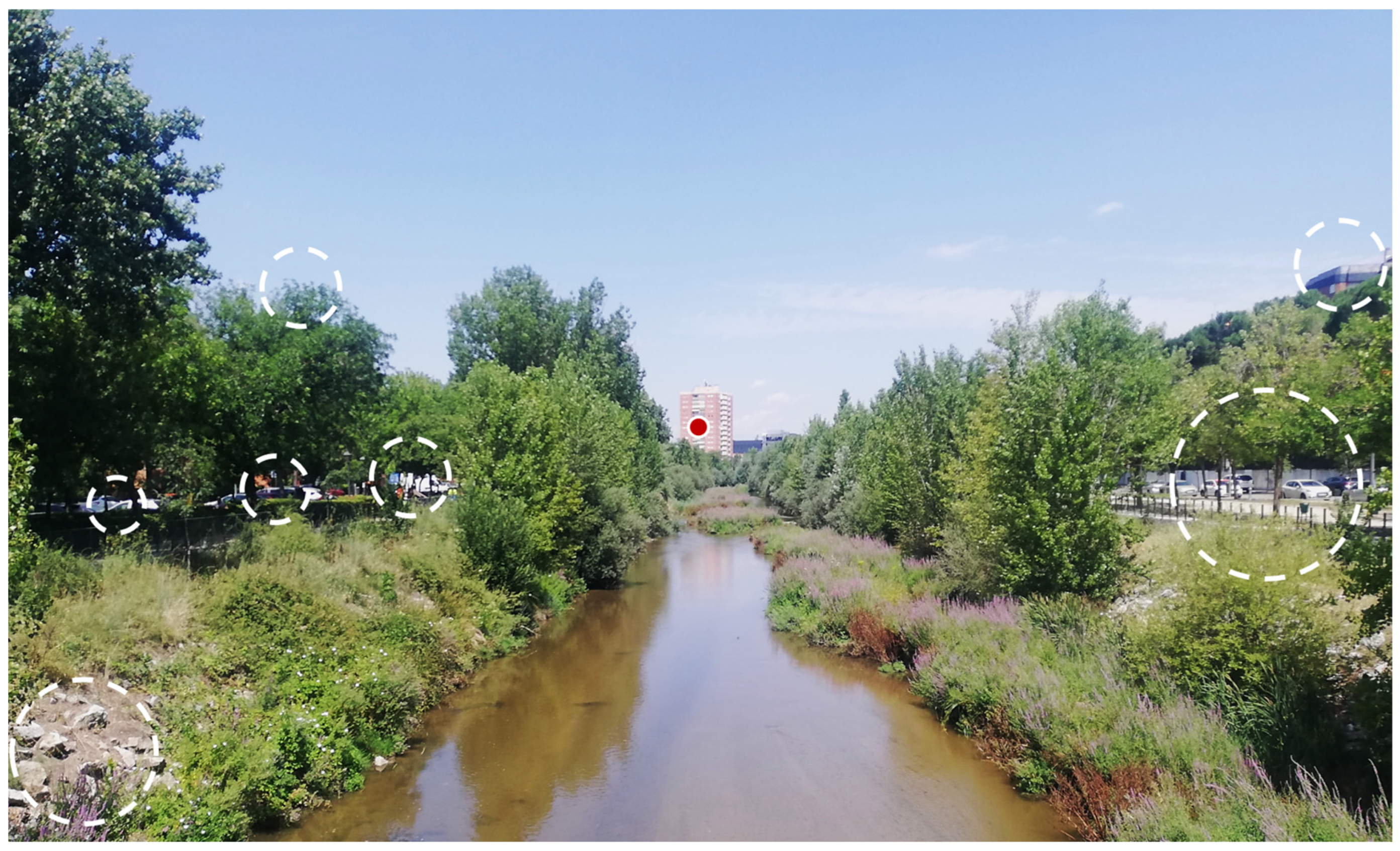
Figure 1. Illustration of the separate functions of the dorsal and ventral pathways/streams during the observation of a landscape scene: the dorsal stream mainly engages with the entirety of salient areas all over the visual field (hollow circles with white, dashed outlines), and the ventral stream emphasizes the central part of the visual field (red circle with white outline in the center of the figure). The figure has been created according to [19].
The exact behavioral tasks and their explicit interconnections with the responding visual pathways/streams and cortical areas are not thoroughly examined here. Yet, the distinctions made in the aforementioned paragraphs are a prerequisite in order to further proceed to the modeling of landscape visual experience (perception) from the human perspective, which is considered by several researchers an essential endeavor (e.g., [20,21,22,23][20][21][22][23]). Towards this direction, several research studies have recently been dedicated to the experimental recording and quantification of landscape visual perception, using mainly methods and sensor-based techniques known as eye tracking and eye movement analysis (e.g., [24,25,26,27,28,29,30,31,32,33,34,35,36,37,38,39,40,41,42][24][25][26][27][28][29][30][31][32][33][34][35][36][37][38][39][40][41][42]). Other research studies have employed other sensor-based experimental techniques and technologies to register and quantify the brain activity during the observation of landscapes (scenes) such as functional Magnetic Resonance Imaging (fMRI) (e.g., [43,44,45,46,47][43][44][45][46][47]) and Electroencephalography (EEG) (e.g., [48,49,50,51,52,53][48][49][50][51][52][53]).
A multitude of other scientific studies have focused—in the last four decades or so—on how to register and quantify visual landscape evaluation (or assessment), mainly using participants/correspondents who observe and rate landscape photographs, by employing several empirical techniques (e.g., [54,55,56,57,58,59,60,61,62,63,64,65,66,67,68,69,70,71,72,73,74,75,76,77][54][55][56][57][58][59][60][61][62][63][64][65][66][67][68][69][70][71][72][73][74][75][76][77]). A recent review article systematically describes and classifies existing landscape evaluation approaches and methodologies adopted, along with indicators developed/selected and technologies used [78].
The visual landscape can be approached/modeled either from the human (ground) standpoint, i.e., the way people experience their surroundings in everyday life (as they stand, walk, etc.), or from a standpoint whereby land is vertically projected from above, i.e., the way maps portray parts of the landscape (in cartographic products and geovisualizations). The first perspective is defined as egocentric while the second one as exocentric (e.g., [21,23,79,80,81][21][23][79][80][81]).
Perhaps the most well-established scientific ‘discipline’ or tradition that adopts the exocentric approach in landscape research is that of Landscape Ecology. Within this tradition, landscapes are considered extensive land mosaics, “over which local ecosystems recur” [82] (p. 20). The inherent structure and the spatial patterns of the ecosystems within a landscape are intertwined with the function and ecological processes of these ecosystems [7[7][83][84][85][86],83,84,85,86], while landscape description and analysis are based on metrics and indices quantifying the planimetric (and vertical) heterogeneity of landscape’s constituent elements [7,8,83,87,88][7][8][83][87][88]. In this sense, landscapes are considered as mind-independently defined geographical entities (i.e., “ecological meaningful units” [89]) characterized by intrinsic heterogeneity (diversity of landscape elements), being described by an exocentric perspective. As a consequence, according to this tradition, landscapes can be objectively analyzed, without the implication of human presence/perception, while criteria, methods, and techniques have been proposed and developed in order to analyze/classify/assess the character of landscapes mainly in Europe, or elsewhere [89,90,91,92,93,94,95,96][89][90][91][92][93][94][95][96].
As mentioned above, these two perspectives are connected to different scientific traditions, as well as to different methods, techniques, indices and metrics, (sensor-based) technologies, and software tools for registering, recording, quantifying, and visualizing the (possible experience of the) landscape. Thus, visual landscape perception and evaluation are, in fact, and can be potentially modeled in different ways, depending on the perspective; even more fundamentally, they have different meanings.
2. The Two Modalities of Approaching the Visual Landscape: Concepts, Methods and Metrics
Exploring whether perception involves concepts and/or cognition (i.e., knowledge) has been a subject of acute philosophical debate in the tradition of the philosophy of mind [102,103,104,105,106,107,108,109,110,111][97][98][99][100][101][102][103][104][105][106] and a subject of scientific debate in the tradition of cognitive science [112,113,114,115,116,117][107][108][109][110][111][112]. Early vision (system) is a very crucial term in this debate, regarding the cognitive (im)penetrability of perception. Early vision can be defined as being “identical to the pure bottom-up (stimulus-driven) visual processes”—corresponding “to the first neural processing stages in the retina and the visual cortex”—“without being influenced by the top-down stream of semantic information” or by the “higher cognitive and semantic cues” [118][113] (p. 740). According to [112][107] (p. 343), “if a system is cognitively penetrable then the function it computes is sensitive, in a semantically coherent way, to the organism’s goals and beliefs, that is, it can be altered in […] relation to what the person knows”. The defenders of cognitive impenetrability of perception argue that during early vision—that is, for the first milliseconds in which only bottom-up processes take place—visual perception is not influenced by cognition (e.g., [112,116][107][111]); as a result, the way one perceives a visual scene, or the world as whole, is distinct from her/his beliefs, expectations, evaluative judgements, etc. This postulation has been refuted by several scholars and researchers, resorting mainly to the fact that visual perception is not limited to early vision [117][112], and that the actual phenomenology of visual experience cannot be described and explained only by the content (i.e., representations) of early vision [115][110]. This divergence between researchers who adopt a bottom-up approach, focusing on the rich array of stimulus from the external world, and those who advocate a top-down approach, emphasizing the cognitive functions inside the brain (e.g., perceiver’s expectations and previous information) in constructing a likely account of what is out there has been characterized by [119][114] (p. 25) as the “major theoretical divide”. In the realm of landscape research, perception and cognition are also present as distinct concepts. The plethora of definitions and meanings for landscape reveals the ambiguity for delineating what a landscape is. Landscapes carry multiple meanings (e.g., [120][115]) which can, for example, refer to a bordered territory, a territorial identity, a scenery, an expression of ideas, etc. [121,122][116][117]. More concisely, Unwin [123][118] (p. 130) defines landscape as “the appearance of the land at the interface of the earth’s surface and atmosphere”. In the noted definition of the European Landscape Convention (ELC), a landscape is: “an area, as perceived by people, whose character is the result of the action and interaction of natural and/or human factors” [124][119]. According to alternative approaches, landscape is conceived as a process or interaction rather than as an object or a finalized product [125[120][121],126], “subjectively ‘in the making’ rather than as an assemblage of physical features” [126][121] (p. 119). “Landscape experience, then, is not just how a given view comes to be represented, but how its viewer stakes a claim to perception and to presence” [127][122] (p. 104). The same ambiguity arises when it comes to the definition of landscape perception. Dupont [122][117] identifies three major meanings for visual perception: (1) The first one refers just to visual sensation: that is the physiological process of collecting information from the environment through senses (e.g., sight (vision)); (2) The second one extends this physiological process, by attaching to sensation other mental or cognitive processes such as understanding or interpretation; (3) The third one solely refers to interpretation or understanding processes, pointing to mental states such as opinions or beliefs. As far as our everyday landscape experience encompasses both a physiological and a psychological (cognitive) component (second meaning), landscape visual perception and landscape evaluation are modalities that may also appear indistinguishable. Landscape observation is influenced by cognition, while landscape evaluation requires the existence of a perceivable area of land; however, several methods and techniques for registering these two different modalities have been developed—albeit, it is not always clear which exact modality is registered each time. As Gobster et al. [128][123] have pointed out, the aesthetic experience type with regard to the landscape emerges from the interaction between the following: (i) The “landscape context”, referring to the different geometric patterns and features of the landscape—potentially eliciting attention to different visual patterns; (ii) The ‘‘situational context’’, referring to the socio-cultural and personal factors influencing the observer (Figure 2).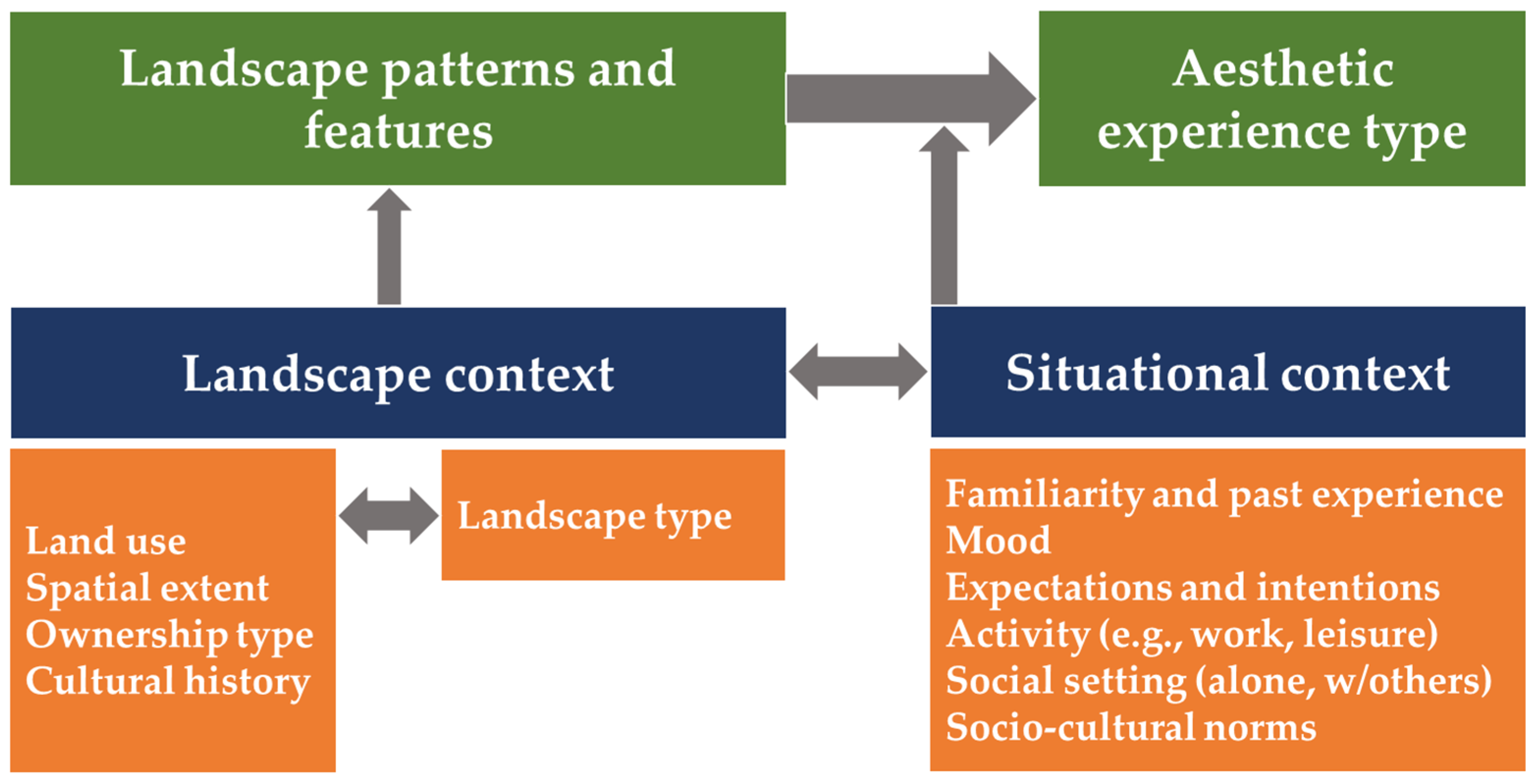
-
Landscape perception is by and large equivalent to the occurring behavioral patterns of visual activity and/or brain activity, while visually experiencing a landscape (scene);
-
Landscape evaluation refers mainly to the people’s judgements or appraisal of landscape, meaning landscape (visual quality) preferences and ratings, while visually experiencing a landscape (scene).
3. Descriptive and Normative Approaches in the Framework of the Two ‘Divergent’ Perspectives for Conceiving/Managing Landscape
3.1. The Two ‘Divergent’ Perspectives for Landscape: Egocentric vs. Exocentric
Fifty years ago, Rimbert [195][124] (pp. 234–235) suggested a generic classification for conceiving and conceptualizing landscapes. According to this classification, there are two essential landscape approaches or perspectives:
-
The one that “apprehends the individual or the human as the starting point”; this approach refers to the philosophical attitude that places the self or the humans at the center of the world; according to this approach “what each individual directly perceives is not a neutral space, but rather an imaginary sphere of personal signs and signals”;
-
The other that “considers space as an object of observation”; this perspective pertains to the philosophical reflection of the Cartesian extension whereby the adopted attitude is that of “an observer that is voluntarily detached from the space-object”.
In this ‘dipole’, there exist two poles/perspectives: the subjective egocentric and the objective exocentric. At the first pole, the subjective experience of each individual is shaped via the egocentric (i.e., human) perspective. Methods, techniques, and metrics for registering and modeling the subjective experience; i.e., human perception and evaluation of the visual landscape have been presented in the previous sub-section. In this sub-section, methods, techniques, and metrics for modeling landscapes regarding the second pole (exocentric perspective) are described.
As previously mentioned, from an egocentric (or ‘anthropocentric’) perspective, landscape is ‘‘an area, as perceived by people, whose character is the result of the action and interaction of natural and/or human factors’’ (European Landscape Convention (ELC) definition) [124][119] or “a geographical area, characterised by its content of observable, natural and human-induced, landscape elements” [196,197][125][126] (p. 559). Landscape elements are “natural or human-induced objects, categories or characteristics, including ecosystem types, which are observable at landscape scale” [197][126].
According to Jones et al. [198][127] (p. 210), the ELC landscape conceptualization contrasts with how landscape is conceptualized and typically defined by Landscape Ecology as “a tangible area of a certain given size and/or related to a certain spatial scale, with specific, pre-defined characteristics”. While the ELC definition emphasizes the culturally-driven manner based on which each human observer ‘constructs’ landscapes from the material environment [198,199][127][128], in “Landscape Ecology a landscape is [rather] defined from the viewpoint from different species including humans” [198][127] (p. 210) or from the ‘view from above’.
Therefore, instead of ceding the primacy to the subjective, egocentric human perspective, one can adopt another approach which lies in studying the landscape itself, as the latter is represented in an exocentric (i.e., vertical) perspective, by quantitatively analyzing its elements and its ‘intrinsic’ properties [21]. As previously mentioned, from the viewpoint of Landscape Ecology landscapes are regarded as extensive, heterogeneous land mosaics composed of clusters of interacting ecosystems which recur in similar form throughout [82,86,198][82][86][127]. Landscape Ecology explicitly studies how ecological processes—the behavior and distribution, i.e., function, of organisms—are affected by landscape pattern [7,200,201][7][129][130]. What is explicitly and quantitatively studied refers to both composition (“how much there is of a particular component”) and spatial form or configuration (“how it is arranged”) [83] (p. 4).
The explicit manner whereby landscape pattern is studied is based on geospatial quantitative analyses employing metrics and/or indices (The terms ‘landscape metrics’ and ‘landscape indices’ are often used interchangeably, as there are no specific rules for when to use the one term over the other [202][131]. The term ‘landscape indices’ appears more frequently when used in a broader sense, while the term ‘landscape metrics’ appears more frequently for metrics calculated within computer programs and software packages (e.g., FRAGSTATS), and it has also become the prevalent term in the last two decades [202][131]. For simplicity, the term ‘landscape metrics’ will be used exclusively in the rest of the paperntry.) that assign values to the planimetric (and vertical) heterogeneity of landscape’s constituent elements and/or patches [7,8,83,87,88][7][8][83][87][88]. Expressing spatial heterogeneity by means of metrics is needed in order to establish quantitative relationships between spatial patterns and ecological processes and spatial patterns [202][131]. In general, the metrics either for quantifying landscape composition or configuration/structure occur by initially either taking into consideration individual grid cells or by identifying and extracting land patches in classified/categorized georeferenced images or maps. A patch is theoretically defined as a relatively uniform surface area that differs from its surroundings in nature or appearance [83,86][83][86]. In practice, patches can be areas of “similar vegetation or land cover” [83] (p. 72) or homogeneous habitat types, while a more technical definition for algorithmically identifying patches on a landscape represented by a rasterized or gridded format consists in delineating “a contiguous group of cells of the same mapped category” [83] (p. 106).
As Uuemaa et al. [202][131] state, a wide variety (hundreds) of metrics have been developed for quantifying categorical map patterns in terms of landscape composition and spatial configuration. Landscape composition metrics—such as relative richness, areal percentage (%) of specific (land, vegetation, habitat) cover types, or Shannon’s diversity index, etc.—and landscape structure metrics—such as contagion (of cell cover types), patch size, shape index of patches, or proximity among patches of the same cover type, etc.—have been employed in a plethora of case studies. These metrics appear in a variety of different themes and applications in the field of landscape ecology such as biodiversity and habitat analysis (e.g., [203,204][132][133]), urban landscape pattern (e.g., [205,206][134][135]), aesthetics of landscape, (e.g., [207,208][136][137]), etc.—according to the way [202][131] summarize and classify the pertinent research studies.
Aside from the multitude of different domains where landscape metrics are used, there are several software packages and tools dedicated to the computation of these metrics. Thus, the most common usage of landscape metrics refers to indices developed for quantifying categorical map patterns [202][131] by using these software packages and tools. In the last three decades, stand-alone software packages specifically designed to compute a variety of landscape metrics for categorical map patterns have been developed, such as FRAGSTATS released in different versions [88,209,210][88][138][139]; add-on modules or plug-ins into existing GIS and image processing/analysis software, including module patterns in IDRISI and Patch Analyst in ArcGIS, LecoS in QGIS [211][140], Arc_LIND in ArcGIS [212][141], etc.; or open source programming libraries such as PyLandStats for automatedly computing landscape metrics in interactive environments [213][142].
3.2. Descriptive Approach: Classification/Characterization Process in Landscape Character Assessment
Landscape Ecology has significantly aided—with the operationalization of its definitions—in creating and defining “one or several ‘landscape categories’ that are to be subjected to management or other actions” [197][126]. In essence, Landscape Ecology enables the classification/characterization and mapping of landscape at a local, national, or continental (e.g., E.U.) level, making use of the exocentric perspective.
The fundamental concept in terms of landscape management and policy making is Landscape Character Assessment (LCA). The basic principles and terminology of LCA (with reference to England and Scotland) have been introduced by Swanwick [90]: “LCA is concerned primarily with landscape character, rather than with landscape quality or value”, while character itself refers to “a distinct, recognisable and consistent pattern of elements in the landscape that makes one landscape different from another, rather than better or worse” [90] (p. 8). In this sense, the process of characterization includes the identification of landscape character types (generic in nature) and of landscape character areas (unique/discrete areas of a particular type), while the end product of characterization is typically a map that classifies a geographic region in landscape types/areas [90].
As a consequence, according to this process, landscapes can be objectively described and analyzed at the sub-national, national, or super-national level, without the implication of human presence/perception and evaluative judgements. To this end, objective/quantitative criteria, methods, and techniques have been developed in order to assess the character of landscapes mainly in Europe or elsewhere [89,90,91,92,93,94,95,96,197][89][90][91][92][93][94][95][96][126]. Such projects have been implemented primarily by employing a GIS-based procedure. Fundamental aspects in this procedure include the choice of key parameters (e.g., topography, parent material, land use, etc.) that are readily available as geospatial data layers and the systematic and traceable combination of these layers into one overarching landscape concept [95]. For instance, European Landscape Classification (LANMAP), as described by [89] (p. 100) “has been used in the initial phase of a Landscape Character Assessment, in order to facilitate the analyses of the structure and pattern of landscapes”, and further aids in covering “the need for a common and geo-referenced classification system of landscapes for Europe”. The final result is the European Landscape Map, LANMAP, a Pan-European geo-referenced, multi-resolution (multiple levels) landscape classification scheme based on geospatial data on climate, altitude, parent material, and land use, mainly derived from satellite imagery [89]. Other similar attempts for classifying the landscape character have been conducted for other regions, e.g., New Zealand [93,94,96][93][94][96]. For an extensive review of other worldwide LCA approaches see [196,214][125][143].
As previously mentioned, LCA “is primarily concerned with documenting landscape character rather than assigning quality or value” [91]. The act of documenting is a value-free process and a rather objective and quantitative one. However, there are two stages in LCA: the characterization, “which is relatively value-free and is concerned with identifying, classifying and describing areas of distinctive character”, and the making-judgements (evaluation) stage “to inform particular decisions, which may use one or a combination of approaches depending on the purpose of the exercise” [90] (p. 16).
3.3. Normative Approach: Evaluation Process in Landscape Character Assessment
The process of characterization or classification provides the central, rather objective framework on which subsequent evaluative judgements about landscape character are to be based [90]. Therefore, assigning value or quality to the landscape (i.e., evaluation) is a separate, normative process which requires the involvement of human cognition and judgement. This process engages, in principle, subjectivity.
In the literature, and in practice, it has been shown that attempts for landscape evaluation adopting the exocentric perspective in a direct manner is a tricky venture. For instance, Tveit et al. [215][144] developed concepts (dimensions, attributes, and indicators) for analyzing the visual character of landscape towards further evaluating the landscape change. This indirect manner of proceeding to landscape evaluation from the exocentric perspective is shown in that “each of these [selected] concepts focuses on different aspects of the landscape important for visual quality, where visual quality is an holistic experience of them all” [215][144] (p. 229). As they explicitly put it, “the visual concepts presented are used to describe different characteristics of visual landscapes, rather than presenting a normative value for visual quality” [215][144] (p. 229). In the same vein, Ode et al. [216][145] claim that a visual assessment that is objective in its nature can form a robust basis for the subsequent evaluation of landscape visual quality; they suggest an approach for describing visual concepts through measurable visual indicators and for further linking visual indicators to theories of landscape perception and preferences (aesthetics). On the contrary, in a very recent review article, Lothian [217][146] concludes that the vast majority of academic research and institutional regulations, particularly in Britain and Europe, fixate on the landscape character and not on landscape quality; due to the allegedly intricate manner of measuring landscape/scenic quality (which also encompass subjectivity), landscape character has become the objectively-measured substitute instead. Yet, this pronounced focus on landscape character alone, and the simultaneous neglect of quality or scenic value, “loses the plot” [217][146] (p. 451).
As it may appear, there is a rather inherent incompatibility of proceeding to landscape evaluation from the exocentric approach without resorting to the visual landscape—i.e., to the landscape as it can be visually perceived via the egocentric perspective. This apparent incompatibility “between the ELC landscape definition” (egocentric perspective) and ‘natural science-based landscape definitions’ (exocentric perspective) has been clearly noted by Erikstad et al. [197][126] (p. 11); besides, this lack of compatibility poses a challenge for both scientific research and planning processes [197][126]. The ‘biophysical landscape concept’ introduced by Simensen et al. [196][125] for methods concerned with the material content (i.e., natural and man-made elements) of the landscape is aligned to ‘natural science-based landscape definitions’ and is compatible with “basic typification, characterisation and mapping of landscapes” which is linked to important practical aspects for landscape management [197][126] (p. 11). Yet, the stage of evaluation transcends the landscape characterization stage which solely “concentrates on what makes one area different from another” [214][143] (p. 53) by resorting to the general (intrinsic) properties of landscape per se. Landscape evaluation entails the expression of judgements about landscape character, further “leading to decisions concerning the management, planning, and protection of the various landscape types/areas” [214][143] (p. 53). Without the verbalized human judgements about the landscape, the characterization of landscape can remain just another useful but inactivate piece of scientific evidence; instead, the scientifically informed evaluative judgements of active citizens can promote and enable the practical implementation of planned actions towards the proper management and protection of landscape types or areas. Thus, landscape evaluation must encompass human perception and citizen participation in processes leading to landscape management [197][126]. Meanwhile, the ‘holistic concept’ of landscape has to be adopted, including “human perception and cultural relations to areas” [196][125].
In order to avoid this impasse (see [214,218][143][147] for the ‘debates’ regarding objective vs. subjective and quantitative vs. qualitative)—since clear-cut natural science-based landscape definitions limit the inclusion of human perception and citizen involvement [197][126]—a viable solution lies in utilizing LCA for objectively/quantitatively specifying and delineating the different geographical areas to be further subjected to the scrutiny of subjective human perception and evaluative judgements. In other words, when it comes to landscape evaluation for pragmatic decision making pertaining to land management and planning, one has to initially comply with the current “classification of landscape description units-LDUs” [214][143] (p. 53), and then resort to judgements of the public which rate/rank the different LDUs based on perceptual, cognitive/emotional, or functional criteria. Yet, rating/ranking the landscape can be attained by means of encompassing the subjective experience of these LDUs in some way.
In their recent conceptual article, Terkenli et al. [214][143] summarize and classify a wide variety of practiced or proposed LCA methodologies according to the way they negotiate the interplay between objective and subjective landscape dimensions, by employing quantitative or qualitative approaches and data. One of the ‘most subjective’ and ‘qualitative’ approaches is the one adopted by Scott [219][148] using LANDMAP for identifying distinctive landscape areas on the one hand, and properly selected photographic material conveyed via household questionnaires/focus groups for evaluating public perception; the results provided important insights into public perception, allowing for particular landscape types and areas to be evaluated—quantitatively and qualitatively. Another ‘very subjective’, but also ‘very quantitative’ approach has been adopted by Atik and Karadeniz [220][149] which integrate the ELC definition into the LCA methodology in order to evaluate the importance and to further identify landscape functions and potentials for different land use of two landscape areas in Turkey based on the evaluation of different biophysical layers and without neglecting the subjectivity of visual characteristics.
In other similar approaches [221][150], various types of landscape characters in specific regions of Turkey are examined in order to determine the visual quality and visual preferences of these different landscape types; nine different landscape character types conveyed via representative photographs/images were evaluated (in terms of landscape scenic beauty, and other parameters, such as vitality, safety, impressiveness, degradation, worth being protected, etc.) by a large number of participants using a questionnaire-based survey. In the recent paper of Criado et al. [222][151] (p. 6395), landscape evaluation is treated as a complementary tool in the assessment of the environment; after identifying the characteristic/distinctive landscape units in urban areas of Spain, the landscape is ‘diagnosed’ based on an objective and quantitative GIS-based evaluation of the landscape situation in each of the identified landscape units, “according the extension (ha) and percentage (%) of each degree (very high, high, moderate, low and very low) of quality, fragility or need for protection in each unit”.
References
- Orians, G.H. Habitat Selection: General Theory and Applications to Human Behavior. In The Evolution of Human Social Behavior; Elsevier: Amsterdam, The Netherlands, 1980.
- Appleton, J. Prospects and Refuges Revisited. In Environmental Aesthetics: Theory, Research, and Application; Nasar, J.L.E., Ed.; Cambridge University Press: Cambridge, UK, 1988; pp. 27–44.
- Appleton, J. The Experience of Landscape; Wiley: Chichester, UK, 1996.
- Gibson, J.J. The Ecological Approach to Visual Perception; Hardcover; Houghton, Mifflin and Company: Boston, MA, USA, 1979; ISBN 0-39527-049-9.
- Kaplan, S.; Kaplan, R. Cognition and Environment: Functioning in an Uncertain World; Praeger: New York, NY, USA, 1982.
- Schwab, I.R. The Evolution of Eyes: Major Steps. the Keeler Lecture 2017: Centenary of Keeler Ltd. Eye 2018, 32, 302–313.
- Turner, M.G. Landscape Ecology: The Effect of Pattern on Process. Annu. Rev. Ecol. Syst. 1989, 20, 171–197.
- O’Neill, R.V.O.; Krumme, J.R.; Gardner, R.H.; Sugihara, G.; Jackson, B.; Deangelist, D.L. Indices of Landscape Pattern. Landsc. Ecol. 1988, 1, 153–162.
- Ware, C. Information Visualization: Perception for Design; Morgan Kaufmann: Burlington, MA, USA, 2019.
- Lothian, A. Landscape and the Philosophy of Aesthetics: Is Landscape Quality Inherent in the Landscape or in the Eye of the Beholder? Landsc. Urban Plan. 1999, 44, 177–198.
- USDA Forest Service. National Forest Landscape Management, Volume 1: Agriculture Handbook No 434; U.S. Government Printing Office: Washington, DC, USA, 1973.
- Bell, S. Elements of Visual Design in the Landscape, 2nd ed.; Spon Press: London, UK, 2004.
- Guo, X.; Qian, Y.; Li, L.; Asano, A. Assessment Model for Perceived Visual Complexity of Painting Images. Knowl.-Based Syst. 2018, 159, 110–119.
- Kingdom, F.A.A.; Mullen, K.T. Separating Colour and Luminance Information in the Visual System. Spat. Vis. 1995, 9, 191–219.
- Sabesan, R.; Schmidt, B.P.; Tuten, W.S.; Roorda, A. The Elementary Representation of Spatial and Color Vision in the Human Retina. Sci. Adv. 2016, 2, e1600797.
- Ungerleider, L.G.; Mishkin, M. Two Cortical Visual Systems. In Analysis of Visual Behavior; Ingle, D.J., Goodale, M.A., Mansfield, R.J.W., Eds.; MIT Press: Cambridge, MA, USA, 1982; pp. 549–586.
- Ungerleider, L.G.; Pessoa, L. hat and Where Pathways. Scholarpedia 2008, 3, 5342.
- Goodale, M.A.; Milner, A.D. Separate Visual Pathways for Perception and Action. Trends Neurosci. 1992, 15, 20–25.
- Sheth, B.R.; Young, R. Two Visual Pathways in Primates Based on Sampling of Space: Exploitation and Exploration of Visual Information. Front. Integr. Neurosci. 2016, 10, 37.
- Schirpke, U.; Tasser, E.; Tappeiner, U. Landscape and Urban Planning Predicting Scenic Beauty of Mountain Regions. Landsc. Urban Plan. 2013, 111, 1–12.
- Misthos, L.-M.; Menegaki, M. Identifying Vistas of Increased Visual Impact in Mining Landscapes. In Proceedings of the 6th International Conference on Computer Applications in the Minerals Industries (CAMI 2016), Istanbul, Turkey, 5–7 October 2016.
- Kent, M.; Schiavon, S. Evaluation of the Effect of Landscape Distance Seen in Window Views on Visual Satisfaction. Build. Environ. 2020, 183, 107160.
- Misthos, L.-M. Development of a Geospatial, Multiparametric Model for Assessing Landscape Impacts from Mining; National Technical University of Athens: Athens, Greece, 2022.
- Berto, R.; Massaccesi, S.; Pasini, M. Do Eye Movements Measured across High and Low Fascination Photographs Differ? Addressing Kaplan’s Fascination Hypothesis. J. Environ. Psychol. 2008, 28, 185–191.
- Dupont, L.; Van Eetvelde, V. The Use of Eye-Tracking in Landscape Perception Research. In Proceedings of the ETRA’14: Proceedings of the Symposium on Eye Tracking Research and Applications, Safety Harbor, FL, USA, 26–28 March 2014; pp. 387–388.
- Kang, Y.; Kim, E.J. Differences of Restorative Effects While Viewing Urban Landscapes and Green Landscapes. Sustainability 2019, 11, 2129.
- Guo, S.; Sun, W.; Chen, W.; Zhang, J.; Liu, P. Impact of Artificial Elements on Mountain Landscape Perception: An Eye-Tracking Study. Land 2021, 10, 1102.
- Li, Z.; Sun, X.; Zhao, S.; Zuo, H. Integrating Eye-Movement Analysis and the Semantic Differential Method to Analyze the Visual Effect of a Traditional Commercial Block in Hefei, China. Front. Archit. Res. 2021, 10, 317–331.
- Misthos, L.; Pavlidis, A.; Karabassakis, E.; Menegaki, M.; Krassanakis, V.; Nakos, B. Exploring the Visual Impact from Open Pit Mines Applying Eye Movement Analyses on Mining Landscape Photographs. Int. J. Min. Reclam. Environ. 2020, 34, 609–624.
- Misthos, L.-M.; Pavlidis, A.; Menegaki, M.; Krassanakis, V. Exploring the Perception of Mining Landscapes Using Eye Movement Analysis. In Proceedings of the 3rd International Workshop on Eye Tracking for Spatial Research, Zurich, Switzerland, 14 January 2018; Kiefer, P., Giannopoulos, I., Göbel, F., Raubal, M., Duchowski, A.T., Eds.; ETH Zurich: Zurich, Switzerland, 2018.
- Huang, A.S.; Lin, Y. The Effect of Landscape Colour, Complexity and Preference on Viewing Behaviour. Landsc. Res. 2020, 45, 214–227.
- Misthos, L.-M.; Menegaki, M. Novel Techniques for Anticipating the Focus of Visual Attention across Different Mining Landscapes. Mater. Proc. 2021, 20, 5020.
- Nordh, H.; Hagerhall, C.M.; Holmqvist, K. Exploring View Pattern and Analysing Pupil Size as a Measure of Restorative Qualities in Park Photos. In Proceedings of the II International Conference on Landscape and Urban Horticulture 881, Bologna, Italy, 25 November 2009; pp. 767–772.
- Ren, X. Consensus in Factors Affecting Landscape Preference: A Case Study Based on a Cross-Cultural Comparison. J. Environ. Manag. 2019, 252, 109622.
- Pihel, J.; Ode Sang, Å.; Hägerhäll, C.; Nyström, M.; Sandström, E. Assessments and Eye Movements Compared between Photographs and Visualizations of Logged Forest Vistas—For What Kind of Assessments Are Visualisations a Good Representation of Photographs? In Peer Reviewed Proceedings of Digital Landscape Architecture 2014 at ETH Zurich; Herbert Wichmann Verlag/VDE Verlag GMBH: Berlin, Germany; Offenbach, Germany, 2014; pp. 344–351.
- Pihel, J.; Ode, Å.; Hagerhall, C.; Nyström, M. Forest Policy and Economics Expert and Novice Group Differences in Eye Movements When Assessing Biodiversity of Harvested Forests. For. Policy Econ. 2015, 56, 20–26.
- Nordh, H.; Hagerhall, C.M.; Holmqvist, K.; Nordh, H.; Hagerhall, C.M.; Tracking, K.H.; Nordh, H.; Hagerhall, C.M. Tracking Restorative Components: Patterns in Eye Movements as a Consequence of a Restorative Rating Task Tracking Restorative Components: Patterns in Eye Movements as a Consequence of a Restorative Rating Task. Landsc. Res. 2013, 6397, 101–116.
- Dupont, L.; Antrop, M.; Van Eetvelde, V. Does Landscape Related Expertise Influence the Visual Perception of Landscape Photographs? Implications for Participatory Landscape Planning and Management. Landsc. Urban Plan. 2015, 141, 68–77.
- Ren, X.; Kang, J. Interactions between Landscape Elements and Tranquility Evaluation Based on Eye Tracking Experiments. J. Acoust. Soc. Am. 2015, 138, 3019–3022.
- Dupont, L.; Ooms, K.; Antrop, M.; Van Eetvelde, V. Comparing Saliency Maps and Eye-Tracking Focus Maps: The Potential Use in Visual Impact Assessment Based on Landscape Photographs. Landsc. Urban Plan. 2016, 148, 17–26.
- Devillez, H.; Guérin-Dugué, A.; Guyader, N. How a Distractor Influences Fixations during the Exploration of Natural Scenes. J. Eye Mov. Res. 2017, 10, 1–13.
- Dupont, L.; Ooms, K.; Duchowski, A.T.; Antrop, M.; Van Eetvelde, V. Investigating the Visual Exploration of the Rural-Urban Gradient Using Eye-Tracking. Spat. Cogn. Comput. 2017, 17, 65–88.
- Zhang, W.; Lai, S. Neural Correlates of Appreciating Natural Landscape and Landscape Garden: Evidence from an FMRI Study. Brain Behav. 2019, 9, e01335.
- Tang, I.; Tsai, Y.; Lin, Y.; Chen, J.; Hsieh, C.; Hung, S.; Sullivan, W.C.; Tang, H.; Chang, C. Landscape and Urban Planning Using Functional Magnetic Resonance Imaging (FMRI) to Analyze Brain Region Activity When Viewing Landscapes. Landsc. Urban Plan. 2017, 162, 137–144.
- Seiyama, A.; Yamada, K.; Osaki, K.; Nakai, R.; Matsumoto, J.; Yoshimura, A. IMedPub Journals Neural Bases on Cognitive Aspect of Landscape Evaluation: A Study Using Functional Magnetic Resonance Imaging. J. Neurol. Neurosci. 2018, 9, 1–6.
- Zhao, X.; Wang, J.; Li, J.; Luo, G.; Li, T.; Chatterjee, A.; Zhang, W.; He, X. The Neural Mechanism of Aesthetic Judgments of Dynamic Landscapes: An FMRI Study. Sci. Rep. 2020, 10, 20774.
- Isik, A.I.; Vessel, E.A. From Visual Perception to Aesthetic Appeal: Brain Responses to Aesthetically Appealing Natural Landscape Movies. Front. Hum. Neurosci. 2021, 15, 414.
- Roe, J.J.; Aspinall, P.A.; Coyne, R. Engaging the Brain: The Impact of Natural versus Urban Scenes Using Novel EEG Methods in an Experimental Setting. Environ. Sci. 2013, 1, 93–104.
- Wang, Y.; Wang, S.; Xu, M. Landscape Perception Identification and Classification Based on Electroencephalogram (EEG) Features. Int. J. Environ. Res. Public Health 2022, 19, 629.
- Kim, M.; Cheon, S.; Kang, Y. Use of Electroencephalography (EEG) for the Analysis of Emotional Perception and Fear to Nightscapes. Preprints 2018, 11, 233.
- Hwang, J.-W.; Hong, C.-U.; Chong, W.-S. SD and EEG Evaluation of the Visual Cognition to the Natural and Urban Landscape. Korean Environ. Sci. Soc. 2006, 15, 305–310.
- Wu, J.; Zhong, Y.; Wang, Y.; Gong, C. Investigating the Relation between Visitor Attention and Visual Quality of Forest Landscape: A Mobile EEG Study. Forests 2022, 13, 1668.
- Wang, Y.; Wang, S.; Xu, M. The Function of Color and Structure Based on EEG Features in Landscape Recognition. Int. J. Environ. Res. Public Health 2021, 18, 4866.
- Hammitv, W.E.; Pattersonb, M.E.; Noe, F.P. Identifying and Predicting Visual Preference of Southern Appalachian Forest Recreation Vistas. Landsc. Urban Plan. 1994, 29, 171–183.
- López-martínez, F. Visual Landscape Preferences in Mediterranean Areas and Their Socio-Demographic Influences. Ecol. Eng. 2017, 104, 205–215.
- Tempesta, T. The Perception of Agrarian Historical Landscapes: A Study of the Veneto Plain in Italy. Landsc. Urban Plan. 2010, 97, 258–272.
- Lindemann-Matthies, P.; Briegel, R.; Schüpbach, B.; Junge, X. Aesthetic Preference for a Swiss Alpine Landscape: The Impact of Different Agricultural Land-Use with Different Biodiversity. Landsc. Urban Plan. 2010, 98, 99–109.
- Bulut, Z.; Yilmaz, H. Determination of Landscape Beauties through Visual Quality Assessment Method: A Case Study for Kemaliye (Erzincan/Turkey). Environ. Monit. Assess. 2008, 141, 121–129.
- Han, K. Environment and Behavior Responses to Six Major Terrestrial Biomes in Terms of Scenic Beauty, Preference. Environ. Behav. 2007, 39, 529–556.
- Arriaza, M. Assessing the Visual Quality of Rural Landscapes. Landsc. Urban Plan. 2004, 69, 115–125.
- Swanwick, C. Land Use Policy Society’s Attitudes to and Preferences for Land and Landscape. Land Use Policy 2009, 26, 62–75.
- Strumse, E. Perceptual Dimensions in the Visual Preferences for Agrarian Landscapes in Western Norway. J. Environ. Psychol. 1994, 14, 281–292.
- Sklenicka, P.; Molnarova, K. Visual Perception of Habitats Adopted for Post-Mining Landscape Rehabilitation. Environ. Manag. 2010, 46, 424–435.
- Misgav, A. Visual Preference of the Public for Vegetation Groups in Israel. Landsc. Urban Plan. 2000, 48, 143–159.
- den Berg, A.E.; Koole, S.L. New Wilderness in the Netherlands: An Investigation of Visual Preferences for Nature Development Landscapes. Landsc. Urban Plan. 2006, 78, 362–372.
- Naspetti, S.; Mandolesi, S.; Zanoli, R. Land Use Policy Using Visual Q Sorting to Determine the Impact of Photovoltaic Applications on the Landscape. Land Use Policy 2016, 57, 564–573.
- Kaltenborn, B.P.; Bjerke, T. Association between Environmental Value Orientations and Landscape Preferences. Landsc. Urban Plan. 2002, 59, 1–11.
- Kellomäki, S.; Savolainen, R. The Scenic Value of the Forest Landscape as Assessed in the Field and the Laboratory. Landsc. Plan. 1984, 11, 97–107.
- Coeterier, J.F. Dominant Attributes in the Perception and Evaluation of the Dutch Landscape. Landsc. Urban Plan. 1996, 34, 27–44.
- Sevenant, M.; Antrop, M. Cognitive Attributes and Aesthetic Preferences in Assessment and Differentiation of Landscapes. J. Environ. Manag. 2009, 90, 2889–2899.
- Browning, M.H.E.M.; Rigolon, A.; Mcanirlin, O.; Violet, H. Landscape and Urban Planning Where Greenspace Matters Most: A Systematic Review of Urbanicity, Greenspace, and Physical Health. Landsc. Urban Plan. 2022, 217, 104233.
- Huai, S.; Van de Voorde, T. Which Environmental Features Contribute to Positive and Negative Perceptions of Urban Parks? A Cross-Cultural Comparison Using Online Reviews and Natural Language Processing Methods. Landsc. Urban Plan. 2022, 218, 104307.
- Svobodova, K.; Sklenicka, P.; Vojar, J. International Journal of Mining, How Does the Representation Rate of Features in a Landscape Affect Visual Preferences? A Case Study from a Post-Mining Landscape. Int. J. Min. Reclam. Environ. 2015, 29, 37–41.
- Svobodova, K.; Sklenicka, P.; Molnarova, K.; Vojar, J. Does the Composition of Landscape Photographs Affect Visual Preferences? The Rule of the Golden Section and the Position of the Horizon. J. Environ. Psychol. 2014, 38, 143–152.
- Barroso, F.L.; Pinto-Correia, T.; Ramos, I.L.; Surová, D.; Menezes, H. Dealing with Landscape Fuzziness in User Preference Studies: Photo-Based Questionnaires in the Mediterranean Context. Landsc. Urban Plan. 2012, 104, 329–342.
- Howley, P.; Donoghue, C.O.; Hynes, S. Exploring Public Preferences for Traditional Farming Landscapes. Landsc. Urban Plan. 2012, 104, 66–74.
- Howley, P. Landscape Aesthetics: Assessing the General Publics’ Preferences towards Rural Landscapes. Ecol. Econ. 2011, 72, 161–169.
- Kang, N.; Liu, C. Towards Landscape Visual Quality Evaluation: Methodologies, Technologies, and Recommendations. Ecol. Indic. 2022, 142, 109174.
- Aznar-Casanova, J.; Matsushima, E. Interaction between Egocentric and Exocentric Frames of Reference Assessed by Perceptual Constancy Parameters. Cogn. Stud. 2008, 15, 22–37.
- Harrower, M.; Sheesley, B. Moving beyond Novelty: Creating Effective 3-D Fly-over Maps. 2002. Available online: https://icaci.org/files/documents/ICC_proceedings/ICC2005/htm/pdf/oral/TEMA15/Session%205/MARK%20HARROWER.pdf (accessed on 5 June 2022).
- Misthos, L.-M. Mountainous Landscape Exploration Visualizing Viewshed Changes in Animated Maps. Master’s Thesis, National Technical University of Athens, Athens, Greece, 2014.
- Forman, R.T.; Forman, R.T.T.; Forman, R.T.T. Land Mosaics: The Ecology of Landscapes and Regions; Cambridge University Press: Cambridge, UK, 1995.
- Turner, M.G.; Gardner, R.H.; O’neill, R.V.; O’Neill, R.V. Landscape Ecology in Theory and Practice; Springer: Berlin/Heidelberg, Germany, 2001; Volume 401.
- Gardner, R.H.; Milne, B.T.; Turner, M.G.; Neill, R.V.O. Neutral Models for the Analysis of Broad-Scale Landscape Pattern. Landsc. Ecol. 1987, 1, 19–28.
- Turnerl, M.G.; Neill, R.V.O.; Gardner, R.H.; Milne, B.T. Effects of Changing Spatial Scale on the Analysis of Landscape Pattern. Landsc. Ecol. 1989, 3, 153–162.
- Forman, R.T.T.; Godron, M. Landscape Ecology Wiley New York; John Wiley and Sons Ltd.: New York, NY, USA, 1986.
- Morzaria-Luna, L.; Callaway, J.C.; Sullivan, G.; Zedler, J.B. Relationship between Topographic Heterogeneity and Vegetation Patterns in a Californian Salt Marsh. J. Veg. Sci. 2004, 15, 523–530.
- McGarigal, K.; Cushman, S.A.; Ene, E. Spatial Pattern Analysis Program for Categorical and Continuous Maps. Computer Software Program Produced by the Authors at the University of Massachusetts, Amherst. FRAGSTATS v4. 2012. Available online: http://www.umass.edu/landeco/research/fragstats/fragstats.html (accessed on 12 September 2016).
- Mücher, C.A.; Klijn, J.A.; Wascher, D.M.; Schaminée, J.H.J. A New European Landscape Classification (LANMAP): A Transparent, Flexible and User-Oriented Methodology to Distinguish Landscapes. Ecol. Indic. 2010, 10, 87–103.
- Swanwick, C. Landscape Character Assessment: Guidance for England and Scotland; Countryside Agency: London, UK, 2002.
- Wascher, D.M. European Landscape Character Areas: Typologies, Cartography and Indicators for the Assessment of Sustainable Landscapes; Landscape Europe: Zeist, The Netherlands, 2005.
- Mücher, S.; Wascher, D. European Landscape Characterisation. In Europe’s Living Landscapes; KNNV Publishing: Zeist, The Netherlands, 2007; pp. 36–47.
- Brabyn, L. Landscape Classification Using GIS and National Digital Databases Landscape Classification Using GIS and National Digital Databases. Landsc. Res. 2007, 21, 37–41.
- Brabyn, L. Classifying Landscape Character. Landsc. Res. 2009, 34, 37–41.
- Mücher, C.A.; Bunce, R.G.H.; Jongman, R.H.G.; Klijn, J.A.; Koomen, A.J.M.; Metzger, M.J.; Wascher, D.M. Identification and Characterisation of Environments and Landscapes in Europe; Alterra: Denver, CO, USA, 2003.
- Brabyn, L. Solutions for Characterising Natural Landscapes in New Zealand Using Geographical Information Systems. J. Environ. Manag. 2005, 76, 23–34.
- Peacocke, C. Perceptual Content; Cambridge University Press: Cambridge, UK, 1989.
- Peacocke, C. A Study of Concepts; The MIT Press: Cambridge, MA, USA, 1992.
- Peacocke, C. Nonconceptual Content Defended. Philos. Phenomenol. Res. 1998, 58, 381.
- McDowell, J.H. Mind and World; Harvard University Press: Cambridge, MA, USA, 1994.
- McDowell, J. Reply to Peacocke on Mind and World. Philos. Phenomenol. Res. 1998, 5, 414–419.
- Fodor, J.A. The Modularity of Mind; MIT Press: Cambridge, MA, USA, 1983.
- Fodor, J. Observation Reconsidered. Philos. Sci. 1984, 51, 23–43.
- Churchland, P.M. Matter and Consciousness; MIT Press: Cambridge, MA, USA, 1984.
- Churchland, P.M. Scientific Realism and the Plasticity of Mind; Cambridge University Press: Cambridge, UK, 1979.
- Churchland, P.M. Perceptual Plasticity and Theoretical Neutrality: A Reply to Jerry Fodor. Philos. Sci. 1988, 55, 167–187.
- Pylyshyn, Z. Is Vision Continuous with Cognition? The Case for Cognitive Impenetrability of Visual Perception. Behav. Brain Sci. 1999, 22, 341–423.
- Pylyshyn, Z.W. Seeing and Visualizing: It’s Not What You Think; MIT Press: Cambridge, MA, USA, 2003; ISBN 0262162172.
- Raftopoulos, A.; Zeimbekis, J. The Cognitive Penetrability of Perception: An Overview. In The Cognitive Penetrability of Perception: New Philosophical Perspectives; Oxford University Press: Oxford, UK, 2015.
- Pagondiotis, C. Cognitive (Im)Penetrability of Vision: Restricting Vision versus Restricting Cognition. In The Cognitive Penetrability of Perception: New Philosophical Perspectives; Zeimbekis, J., Raftopoulos, A., Eds.; Oxford University Press: Oxford, UK, 2015.
- Raftopoulos, A. The Cognitive Impenetrability of Perception and Theory-Ladenness. J. Gen. Philos. Sci. 2015, 46, 87–103.
- Moore, C.M. Cognitive Impenetrability of Early Vision Does Not Imply Cognitive Impenetrability of Perception. Behav. Brain Sci. 1999, 22, 385–386.
- Julesz, B. Early Vision and Focal Attention. Rev. Mod. Phys. 1991, 63, 735.
- Thompson, C.W. Landscape Perception and Environmental Psychology. In The Routledge Companion to Landscape Studies; Routledge: London, UK, 2013; pp. 43–60.
- Talento, K.; Amado, M.; Kullberg, J.C. Landscape-A Review with a European Perspective. Land 2019, 8, 85.
- Antrop, M. Antrop, M. A Brief History of Landscape Research. In The Routledge Companion to Landscape Studies; Routledge: London, UK, 2018; pp. 1–15.
- Dupont, L. Take a Look at the Landscape!: An Eye-Tracking Study of Landscape Observation and Its Influencing Factors. Ph.D. Thesis, Ghent University, Flanders, Belgium, 2016.
- Unwin, K.I. The Relationship of Observer and Landscape in Landscape Evaluation. Trans. Inst. Br. Geogr. 1975, 130–134.
- Council of Europe. The European Landscape Convention—Firenze, 20X; (ETS No. 176) Official Text in English; Council of Europe: Strasbourg, France, 2000.
- Wylie, J. Landscape and Phenomenology. In The Routledge Companion to Landscape Studies; Routledge: London, UK, 2013; pp. 72–83.
- Crouch, D. Landscape, Performance and Performativity. In The Routledge Companion to Landscape Studies; Routledge: London, UK, 2013; pp. 137–146.
- DeLue, R.; Elkins, J. Landscape Theory; Routledge: London, UK, 2010; Volume 6.
- Gobster, P.H.; Nassauer, J.I.; Daniel, T.C.; Fry, G. The Shared Landscape: What Does Aesthetics Have to Do with Ecology? Landsc. Ecol. 2007, 22, 959–972.
- Rimbert, S. Approches Des Paysages. Espace. Geogr. 1973, 2, 233–241.
- Simensen, T.; Halvorsen, R.; Erikstad, L. Methods for Landscape Characterisation and Mapping: A Systematic Review. Land Use Policy 2018, 75, 557–569.
- Erikstad, L.; Uttakleiv, L.A.; Halvorsen, R. Characterisation and Mapping of Landscape Types, a Case Study from Norway. Belgeo. Rev. Belg. Géogr. 2015.
- Jones, M.; Howard, P.; Olwig, K.R.; Primdahl, J.; Jones, M.; Howard, P.; Olwig, K.R.; Primdahl, J.; Jones, M.; Howard, P.; et al. Multiple Interfaces of the European Landscape Convention Multiple Interfaces of the European Landscape Convention. Nor. Geogr. Tidsskr.—Nor. J. Geogr. 2007, 61, 207–216.
- Fairclough, G. ‘The Long Chain’: Archaeology, Historical Landscape Characterization and Time Depth in the Landscape. Landsc. Interfaces Cult. Herit. Chang. Landsc. 2003, 1, 295–318.
- Fahrig, L. When Is a Landscape Perspective Important. In Issues and Perspectives in Landscape Ecology; Cambridge University Press: Cambridge, UK, 2005; pp. 3–10.
- Wiens, J.A. Landscape Mosaics and Ecological Theory. In Mosaic Landscapes and Ecological Processes; Springer: Dordrecht, The Netherlands, 1995; pp. 1–26.
- Uuemaa, E.; Antrop, M.; Marja, R. Landscape Metrics and Indices: An Overview of Their Use in Landscape Research Imprint/Terms of Use. Living Rev. Landsc. Res. 2009, 3, 1–28.
- Henner, C.M.; Chamberlain, M.J.; Leopold, B.D.; Burger Jr, L.W. A Multi-Resolution Assessment of Raccoon Den Selection. J. Wildl. Manag. 2004, 68, 179–187.
- Kindall, J.L.; Van Manen, F.T. Identifying Habitat Linkages for American Black Bears in North Carolina, USA. J. Wildl. Manag. 2007, 71, 487–495.
- Tang, J.; Wang, L.; Yao, Z. Analyzing Urban Sprawl Spatial Fragmentation Using Multi-Temporal Satellite Images. GIScience Remote Sens. 2006, 43, 218–232.
- Gonzalez-Abraham, C.E.; Radeloff, V.C.; Hammer, R.B.; Hawbaker, T.J.; Stewart, S.I.; Clayton, M.K. Building Patterns and Landscape Fragmentation in Northern Wisconsin, USA. Landsc. Ecol. 2007, 22, 217–230.
- Lee, S.-W.; Ellis, C.D.; Kweon, B.-S.; Hong, S.-K. Relationship between Landscape Structure and Neighborhood Satisfaction in Urbanized Areas. Landsc. Urban Plan. 2008, 85, 60–70.
- Sang, N.; Miller, D. Landscape Metrics and Visual Topology in the Analysis of Landscape Preference. Environ. Plan. B Plan. Des. 2008, 35, 504–521.
- McGarigal, K.; Marks, B.J. : Spatial Pattern Analysis Program for Quantifying Landscape Structure; U.S. Department of Agriculture, Forest Service, Pacific Northwest Research Station: Portland, OR, USA, 1995.
- McGarigal, K.; Cushman, S.A.; Neel, M.C.; Ene, E. FRAGSTATS: Spatial Pattern Analysis Program for Categorical Maps; University of Massachusetts: Amherst, MA, USA, 2002.
- Jung, M. Ecological Informatics LecoS—A Python Plugin for Automated Landscape Ecology Analysis. Ecol. Inform. 2016, 31, 18–21.
- Yu, M. Ecological Informatics An ArcMap Plug-in for Calculating Landscape Metrics of Vector Data ☆. Ecol. Inform. 2019, 50, 207–219.
- Id, B. PyLandStats: An Open-Source Pythonic Library to Compute Landscape Metrics. PLoS ONE 2019, 14, e0225734.
- Terkenli, T.S.; Gkoltsiou, A.; Kavroudakis, D. The Interplay of Objectivity and Subjectivity in Landscape Character Assessment: Qualitative and Quantitative Approaches and Challenges. Land 2021, 10, 53.
- Tveit, M.; Ode, Å.; Fry, G. Key Concepts in a Framework for Analysing Visual Landscape Character Key Concepts in a Framework for Analysing Visual Landscape Character. Landsc. Res. 2006, 31, 229–255.
- Ode, Å.; Tveit, M.S.; Fry, G. Using Indicators: Touching Base with Landscape Aesthetic Theory Capturing Landscape Visual Character Using Indicators: Touching Base with Landscape Aesthetic Theory. Landsc. Res. 2008, 33, 89–117.
- Lothian, A. Visual Resource Stewardship—An International Perspective. Land 2022, 11, 451.
- Mahan, A.; Mansouri, S.A. Developing a Landscape Assessment Model. Sci. J. NAZAR Res. Cent. (Nrc) Art Archit. Urban. 2017, 14, 31–40.
- Scott, A. Assessing Public Perception of Landscape: The LANDMAP Experience LANDMAP Experience. Landsc. Res. 2002, 27, 271–295.
- Atik, M.; Karadeniz, N. New Approaches for New Regions. In Routledge Handbook of Landscape Character Assessment; Fairclough, G., Herlin, I.S., Swanwick, C., Eds.; Routledge: Abingdon, VA, USA, 2018; pp. 69–79.
- Asur, F.; Deniz Sevimli, S.; Yazici, K. Visual Preferences Assessment of Landscape Character Types Using Data Mining Methods (Apriori Algorithm): The Case of Alt{\i}nsaç and Inkoy (Van/Turkey). J. Agric. Sci. Technol. 2020, 22, 247–260.
- Criado, M.; Mart, A.; Santos-franc, F.; Merch, L. Landscape Evaluation as a Complementary Tool in Environmental Assessment. Study Case in Urban Areas: Salamanca (Spain). Sustainability 2020, 12, 6395.
More