 +1 credit
| Version | Summary | Created by | Modification | Content Size | Created at | Operation |
|---|---|---|---|---|---|---|
| 1 | Eva Hernández Gress | -- | 2064 | 2024-01-09 19:36:11 |
Video Upload Options
In humanitarian logistics, efficiently evacuating people during disasters poses a significant challenge. Comprehensive plans are essential for moving individuals from affected areas, encompassing both pre- and post-disaster phases. These plans must optimize resource usage, including public transportation, and consider those with mobility challenges.
1.Introduction
1.1. Problem Statement
Hazard events, exacerbated by climate change, present an escalating threat to humanity, with 90% of extreme events linked to climate change, potentially increasing in frequency year after year [1]. In 2021, 401 disasters occurred globally, with storms and floods being the most frequent, causing substantial economic impacts and loss of human lives. Latin America and the Caribbean faced significant challenges, particularly with floods, as illustrated in Figure 1.
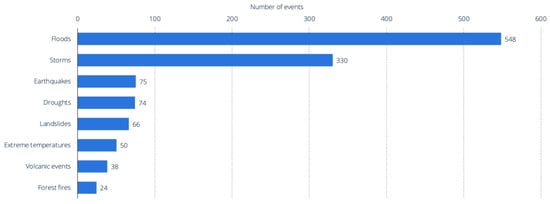
Figure 1. Most common hazard events in Latin America and the Caribbean from 2000 to 2019, by number of occurrences. Source: [2]
Facility location involves strategically positioning warehouses and distribution centers for emergency resources, while distribution studies focus on forming the distribution network, selecting transportation modes, and determining required capacities [4],[5],[6],[7]. Inventory-related challenges revolve around resource levels, availability, cost minimization, and demand forecasting [8]. Mass evacuation planning encompasses shelter location, evacuation point concentration, transport selection, traffic management, and the time required for evacuation [9],[10].
Despite the growing interest in the HSC, the pre-disaster phase, particularly concerning mass evacuation, has received relatively less attention [4],[11] .This phase is crucial for effective disaster management, and the literature on post-disaster decision-making often lacks a systematic examination of multilevel service networks [10]. Future research should explore characterizing victims' needs and systematically examining service networks for comprehensive disaster preparedness.
Effective evacuation planning in disaster scenarios must consider both pre- and post-disaster phases, ensuring efficient resource utilization, including public transportation, and addressing the needs of individuals with mobility difficulties and disabilities [12],[13],[14],[15],[16]. In Mexico, various HSC initiatives have been undertaken across different domains, such as food banks, vaccine distribution, and food and donation collection, utilizing diverse solution approaches. This study focuses on a case study methodology for evacuating people in a flood scenario, employing a mathematical optimization model utilizing integer linear programming (ILP). Additionally, the study utilizes the vehicle routing problem (VRP) to assess various strategies for delivering humanitarian aid.
In the State of Hidalgo, Mexico, the Tula River poses a continuous flood threat to the municipalities it traverses. Despite annual flood events being common, one of the most severe floods in recent memory occurred on 6 September 2021, claiming 15 lives and severely affecting over 31,000 homes [19,20]. The disaster was precipitated by heavy rains in Mexico City and the State of Mexico, leading to the saturation of the drainage system. The National Water Commission activated the Joint Operation Protocol for Deep Drainage of the Valley of Mexico, causing the Tula River to swell, overflow its banks, and significantly increase its flow. This overflow affected several municipalities, including Tula de Allende, Ixmiquilpan, Tlaxcoapan, Tezontepec de Aldama, Chilcuautla, Tasquillo, Tlahuelilpan, Tepeji del Río, and Mixquiahuala [21].
The drainage system in the Valley of Mexico is interconnected through tunnels and canals, facilitating water discharge into the Mezquital Valley via the Tula River. However, this setup has adverse consequences for managing urban stormwater, requiring a comprehensive approach involving public policy, defense structures, diversion gates, river realignment, dredging, damage control, and mitigation efforts. Public awareness and preparedness are crucial, ensuring the population is well-informed about flood risks and aware of evacuation and safety zones to protect human lives [22,23].
1.2. Problem Description
This paper presents a comprehensive strategy to evacuate residents from Tula River-impacted municipalities before a disaster and offer humanitarian assistance in shelters afterward. The approach aims to minimize costs and collaboratively plan essential resources, including determining the number and placement of shelters based on calculations of the affected population and establishing routes for delivering aid to these shelters. Importantly, this strategy is grounded in real-world data, incorporating distances and costs, providing valuable decision-making tools for state and federal governments.
In Section 2, we review the existing literature on evacuation strategies, focusing on both pre- and post-disaster stages. While some works have presented case studies encompassing both phases, their solutions often involve complex methodologies [24]. The proposed strategy aims to offer a more straightforward approach to planning shelters, evacuating vulnerable individuals, and distributing aid.
2. Literature Review
In recent years, there has been a substantial surge in publications pertaining to humanitarian supply chains (HSCs). These publications have addressed various key aspects, including facility location, distribution models, inventory management, and mass evacuation procedures. Furthermore, different mathematical models have been put forth for the evacuation of people, employing a range of algorithmic solutions tailored to the unique characteristics of the specific problem at hand. Within the context of HSCs, there exist conditions of uncertainty, particularly in relation to the demand for assistance. Addressing such uncertainty is crucial when devising evacuation models.
In the field of humanitarian logistics, various models have been developed to address diverse objectives. These objectives include the allocation of ambulances under uncertain conditions, the minimization of vehicle numbers, travel cost reduction, limiting maximum latency, optimizing shelter locations, and efficient distribution of aid. Additionally, challenges related to facility location, distribution, inventory management, and mass evacuation have been tackled using multi-objective optimization and multi-period distribution planning, often employing metaheuristic techniques like the Non-Dominated Sorting Genetic Algorithm III, simulated annealing (SA), and variable neighborhood search (VNS) due to the inherent complexity [24–29].
The humanitarian supply chain (HSC) is characterized by four distinct phases: prevention, preparedness, response, and reconstruction and recovery. Decisions made in the pre-disaster phase significantly influence those in the post-disaster phase. The location of distribution centers, the availability of inventory, and the positioning of shelters all play pivotal roles in the distribution of relief supplies and the evacuation of people. Concerning both the pre-disaster and post-disaster phases, problems related to stock prepositioning, facility placement, evacuation planning, and hospital and distribution center locations have been addressed. These complex challenges have been approached using various metaheuristics, including classical approaches (CAs), pattern search algorithms (PSAs), genetic algorithms (GAs), and Non-Dominated Sorting Genetic Algorithm III [15,28–30].
One of the most critical issues within the HSC domain is the efficient mass evacuation of people for providing timely care to victims. The literature offers proposals to minimize the costs of rescue operations while giving priority to injured individuals. These proposals also cover scheduling and assigning rescue teams, taking into account factors like fatigue and deprivation time. Metaheuristic methods, such as genetic algorithms (GAs) and particle swarm optimization (PSO), have been employed to solve these models [16–18].
Among the recent contributions, Shehadeh and Tucker [31] focused on determining the location of humanitarian aid warehouses in both the pre- and post-disaster phases, considering uncertainty, and positioning inventory. Seraji et al. [32] optimized the placement of emergency shelters and coordinated the movement of aid vehicles using two-stage multi-objective metaheuristics. Table 1 provides a summary of the articles found in the literature that explore approaches in both pre- and post-disaster scenarios, along with the solution methods, some of which have been applied in real-world cases.
| Author(s) | Problem | Phase (Pre- or Post- Disaster) | Solution Method (Approach) | Case Study |
|---|---|---|---|---|
| Babaei and Shahanaghi [25] | Multilevel location allocation and emergency routing problem in uncertain conditions | Post-disaster | Monte Carlo simulation and simulated annealing | No |
| Molina [26] | Multi-objective capacitated vehicle routing problem to deal with the lack of available vehicles and the need for quick evacuation | Post-disaster | MultiStart algorithm with intelligent neighborhood selection (NSGA-II) | No |
| Molla et al. [24] | Relief distribution during flooding and the evacuation of people | Pre- and post-disaster | Mixed-integer programming and genetic algorithms | Yes |
| Jha et al. [27] | Humanitarian relief chain that includes a relief goods supply chain and an evacuation chain in case of natural disaster | Pre- and post-disaster | Mixed-integer programming and NSGA-II | No |
| Doodman et al. [28] | Relief item prepositioning and multi-period distribution planning | Post-disaster | Multi-objective two-stage stochastic programming and TH method | No |
| Seraji et al. [32] | Location of shelters in the first phase and demands after accommodation in the second phase | Pre- and post-disaster | Two-stage stochastic programming | No |
| Zhu et al. [16] | Emergency relief routing optimization considering equity and priority issues | Post-disaster | Metaheuristic based on ant colony optimization | Yes |
| Mansoori et al. [18] | Minimize (a) the total number of people not transferred to hospitals and homeless not evacuated, and (b) total relief commodities | Post-disaster | Multi-objective mathematical model | Yes |
| Nayeri et al. [17] | Allocate and schedule rescue teams considering deprivation costs and times | Pre-disaster | Multi-objective mixed-integer programming using the LP method and a metaheuristic algorithm | No |
| Shehade and Tucker [31] | Determine where to open warehouses and how much inventory to preposition in each | Pre- and post-disaster | Two-stage stochastic programming and distributionally robust optimization (DRO) models | No |
| Madani et al. [33] | Multi-echelon and multi-objective relief network, location of hospitals, local warehouse hybrid centers, and evacuation of people | Pre- and post-disaster | Hybrid non-dominated sorting genetic algorithm and variable neighborhood search | No |
| Agarwal et al. [30] | Logistics stock prepositioning and evacuation planning | Pre- and post-disaster | Mathematical model for decision making with pattern simulated annealing and genetic algorithms | Yes |
| Seraji et al. [32] | Optimize the location of emergency shelters and coordinate the movement of relief vehicles considering distributive injustice and dissatisfaction | Pre- and post-disaster | Two stage multi-objective metaheuristics: multi-objective vibration damping and NSGA II | No |
Other works involving individuals with disabilities include the one by Yazdani and Haghani [34], where they presented a case study in Australia for evacuating the elderly using optimization algorithms combined with behavioral training. The same authors also introduced an emergency plan for relocating vulnerable individuals to shelters in response to heatwaves, presenting a method that they tested in a set of randomly generated locations [35].
While more methods with a broader scope exist, involving larger networks and traffic modeling, and considering human behavior [36], in the case of the Tula River, the network only encompasses 50 possible shelters, 9 assembly points, and 2 distribution centers for aid, also without different route options. Thus, integer programming models are sufficient for making quick decisions. The concept of nearest and safest allocation, as outlined by Southworth [37] and Barrett et al. [38], is employed, and this planning is conducted in advance of flooding.
3.Methodology
The proposed strategy involves data collection, building an evacuation model using integer linear programming (ILP), solving the model, and generating aid distribution options. The simplicity of the decision-making model, utilization of real demographic data, consideration for vulnerable individuals, and coverage of both pre- and post-disaster phases are key contributions.
The mathematical optimization model aims to determine the optimal number and location of shelters, evacuation routes, and aid distribution strategies. By using ILP, the model can efficiently handle the decision variables, constraints, and objectives associated with the evacuation process. The methodology also includes the utilization of the vehicle routing problem (VRP) to assess various strategies for delivering humanitarian aid to the identified shelters.
4.Results and Discussion
The results of the proposed strategy showcase a straightforward approach to planning shelters, evacuating vulnerable individuals, and distributing aid. Real-world data enhance the reliability of the proposed strategy, ensuring its applicability in practical scenarios. The study emphasizes demographic and social factors, specifically targeting individuals over 60 and those with physical disabilities.
The simplicity of the decision-making model makes it accessible for implementation by state and federal governments. The consideration of real demographic and social data adds a layer of realism to the model, improving its accuracy in predicting the needs of the affected population. By encompassing both pre- and post-disaster phases, the strategy provides a holistic approach to evacuation planning.
5. Conclusions
This paper presents a comprehensive strategy for evacuating flood-prone areas, focusing on the Tula River case in Mexico. By incorporating both pre- and post-disaster phases and leveraging real-world data, the proposed model offers a practical and effective decision-making tool for governments. The study underscores the importance of addressing the specific needs of vulnerable populations in evacuation planning.
In conclusion, the proposed strategy provides a valuable contribution to the field of humanitarian supply chain research. Emphasizing simplicity, real-world applicability, and inclusivity in disaster management, the strategy can serve as a blueprint for other regions facing similar challenges. Future research should continue exploring ways to optimize evacuation planning, considering various scenarios and demographic factors, to enhance the resilience of communities facing natural disasters. The implementation of the proposed strategy in collaboration with relevant authorities could significantly improve the efficiency and effectiveness of evacuation processes in flood-prone areas.
References
- Los desastres son la nueva normalida. Organización de las Naciones Unidas. Retrieved 2024-1-9
- Common Natural Disasters in Latin America and the Caribbean from 2000 to 2019.. UNOCHA. Retrieved 2024-1-9
- Chiappetta, C.J.; Sobreiro, V.A.; de Sousa Jabbour, A.B.L.; Campos, L.M.S.; Mariano, E.B.; Renwick, D.W.S. An analysis of the literature on humanitarian logistics and supply chain management: Paving the way for future studies. Ann. Oper. Res. 2019, 283, 289–307. https://doi.org/10.1007/s10479-017-2536-x.. Ann. Oper. Res. 2019, 283, 289-307.
- Hezam, I.M.; Nayeem, M.K. A Systematic Literature Review on Mathematical Models of Humanitarian Logistics. Symmetry. 2020, 13, 11.
- Nunes, R.M.S.; Pereira, S.C.F. Intellectual structure and trends in the humanitarian operations field. Ann. Oper. Res. 2022, 319, 1099–1157. https://doi.org/10.1007/s10479-021-04022-2.. Ann. Oper. Res.. 2022, 319, 1099-1157.
- Witkowski, J.; Marcinkowski, J. Initiators and motives for cooperation in humanitarian supply chains. LogForum 2022, 18, 263–274. 2022, 18, 263-274.
- Repík, D.; Foltin, P. Applications of Performance Indicators for Optimization of Humanitarian Chains. LogForum. 2022, 18, 495-504.
- Shafiq, M.; Soratana, K. Humanitarian Logistics and Supply Chain Management-A Qualitative Study. LogForum 2019, 15, 19–38. 2019, 15, 19-38.
- 11. Habib, M.S.; Lee, Y.H.; Memon, M.S. Mathematical models in humanitarian supply chain management: A systematic literature review. Math. Probl. Eng.. 2016, 3212095, 1-10.
- Zhang, L.; Cui, N. Humanitarian logistics and emergency relief management: Hot perspectives and its optimization approach, 5th International Conference on Advances in Energy. . J. Environ. Chem. . 2021, 245, 03036.
- Santana-Robles, F.; Hernández-Gress, E.S.; Hernández-Gress, N.; Granillo-Macias, R. Metaheuristics in the Humanitarian Supply Chain. Algorithms. 2021, 14, 364.
- Baou, E.; Koutras, V.P.; Zeimpekis, V.; Minis, I. Emergency evacuation planning in natural disasters under diverse population and fleet characteristics. J. Humanit. Logist. Supply Chain Manag. . 2018, 8, 447-476.
- Seraji, H.; Tavakkoli-Moghaddam, R.; Soltani, R. A two-stage mathematical model for evacuation planning and relief logistics in a response phase.. Int. J. Ind. Syst. 2019, 12, 129–144. 2019, 12, 129-144.
- Zhu, L.; Gong, Y.; Xu, Y.; Gu, Y. Emergency relief routing models for injured victims considering equity and priority. Ann. Oper. . 2019, 283, 1573-1606.
- Nayeri, S.; Tavakkoli-Moghaddam, R.; Sazvar, Z.; Heydari, J. Solving an Emergency Resource Planning Problem with Deprivation Time by a Hybrid MetaHeuristic Algorithm. . J. Qual. Eng. Prod. . 2020, 5, 65-86.
- Mansoori, S.; Bozorgi-Amiri, A.; Pishvaee, M.S. A robust multi-objective humanitarian relief chain network design for earthquake response, with evacuation assumption under uncertainties. Neural Comput. Appl. . 2020, 32, 2183-2203.

