 +1 credit
| Version | Summary | Created by | Modification | Content Size | Created at | Operation |
|---|---|---|---|---|---|---|
| 1 | Langping LI | -- | 2590 | 2023-12-22 15:11:03 | | | |
| 2 | Langping LI | Meta information modification | 2590 | 2023-12-22 15:14:46 | | | | |
| 3 | Jessie Wu | Meta information modification | 2590 | 2023-12-25 03:52:37 | | | | |
| 4 | Jessie Wu | Meta information modification | 2590 | 2023-12-25 04:06:04 | | | | |
| 5 | Jessie Wu | Meta information modification | 2590 | 2023-12-25 04:06:51 | | | | |
| 6 | Jessie Wu | + 13 word(s) | 2603 | 2023-12-25 04:18:26 | | | | |
| 7 | Jessie Wu | -111 word(s) | 2492 | 2023-12-25 04:21:18 | | |
Video Upload Options
Natural hazards constantly threaten the sustainable construction and operation of railway engineering facilities, making railway disaster risk assessment an essential approach to disaster prevention. Despite numerous studies that have focused on railway risk assessment, few have quantified specific damages, such as economic losses and human casualties. Meanwhile, the mechanism of impact damage from various disasters on railway facilities and the propagation of functional failure in railway systems have not been thoroughly summarized and addressed. Thus, it is essential to conduct effective quantitative risk assessments (QRAs) to facilitate the sustainable design, construction, and operation of rail infrastructure.
1. Introduction
Railway traffic incidents related to disasters can disrupt traffic operations and cause irreparable damage and casualties. Natural disasters, including landslides, rockfalls, and floods, have caused serious physical and functional damage to railway structures, even resulting in the paralysis of the entire railway system. A detailed risk assessment is urgently needed to improve the safety of and reduce the maintenance costs of railway construction. Such an assessment can provide scientific support for risk prevention and emergency plans. However, the majority of risk assessment methods rely on a qualitative assessment approach, which usually requires experienced experts to judge items, such as the analytic hierarchy process (AHP) method and index weight method. Even some studies that claim to use quantitative risk assessment (QRA) methods fail to quantify specific economic losses or casualties, particularly for railway engineering with complex facilities and exposure to multi-hazard risks. The problem stems from three main factors. Firstly, railway infrastructures are classified into various facilities, such as tunnels, bridges, and roadbeds, each containing a wide range of detailed components with varying attributes based on geometry and material properties. Secondly, the impact damage of disasters on railway engineering infrastructure is a highly complicated changing process of interaction between the engineering components and disasters. Thirdly, due to the complexity and interdependence of railway systems, it is particularly important to evaluate the damage and failure sequence of components of a track–bridge system for railways under disasters. In recent years, building information modeling (BIM) has become a popular tool for infrastructure construction projects due to its digital and automated capabilities. This necessitates the integration of geographic information systems (GIS) with BIM to provide geographic querying, spatial analysis, and dynamic simulation capabilities. A QRA approach for residential buildings based on BIM+GIS technology has been proposed to produce risk maps and predict specific disaster losses. Despite BIM+GIS having been applied to risk management in many domains, there remains a paucity of previous research on refined disaster QRA for the complex structures and facilities of railway engineering. This research provides a comprehensive review of the issues related to disaster QRA for the railway engineering system.
2. Overview of Disaster Risk Assessment for Railways
2.1. Disaster Risk Assessment for Railway Bridges
2.2. Disaster Risk Assessment for Railway Tunnels
2.3. Disaster Risk Assessment for Railway Roadbeds
3. Limitations of Quantitative Disaster Risk Assessment for Railways
- (1)
-
The physical and functional characteristics of railway facility components vary. As a result, changes in the indicators of various components do not indicate variation in the tendency of entire engineering facilities.
- (2)
-
There are no detailed studies about the damage (e.g., impact energy) caused by disasters to railway facilities, especially complex structural components. The dissipation of impact energy and the resulting variations in component damage are still unclear.
- (3)
4. Challenges in Quantitative Disaster Risk Assessment for Railways
The TQRA is obtained by evaluating the probability of a disaster occurring as well as the specific losses suffered by the disaster-bearing entity, including economic losses and human casualties. The main reason for limitations has been attributed to a lack of advanced fine modeling approaches to express the diverse characteristics of components in engineering facilities, an investigation of the relationship between engineering facility structures and environmental conditions, and a system that includes the entire facility as well as the surrounding environment. Figure 1 shows the main study methodologies and challenges for QRA in railway systems.
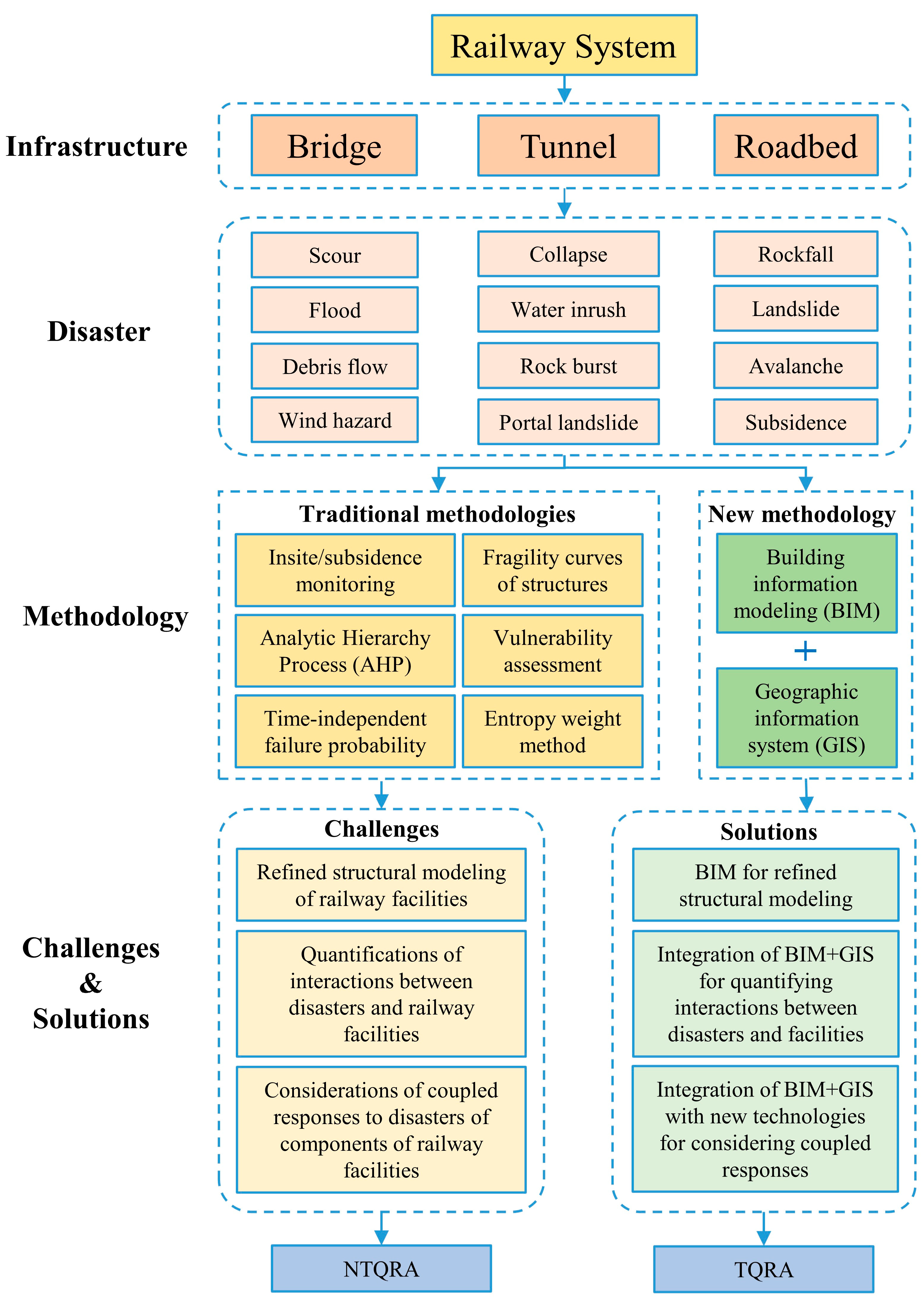
Figure 1. Flowchart of this research about QRA for railway engineering.
4.1. Refined Structural Modeling of Railway Facilities
Due to their complicated structures, engineering facilities with linear properties, such as railway bridges, tunnels, and roadbeds, are difficult to represent using simple 3D shapes. So, employing refined modeling representation is particularly crucial in the context of railway project planning, since these structures not only have a very large extent (hundreds of kilometers) but also the structural components must be designed in the scope of only a few cm in length to provide the required connections and avoid spatial conflicts.
4.2. Quantifications of Interactions between Disasters and Railway Facilities
To achieve a more accurate quantitative susceptibility assessment, both the material characteristics of the risk-bearing body and the physical processes of disasters must be incorporated into the susceptibility calculation. For railway facilities, the catastrophe damage is mostly caused by the interaction process between the disaster and the engineering structure. These interactions include the impact of geological hazards on engineering facilities, the scouring effect of floods on bridge piers, the destructive processes of rock burst and water inrush in tunnels, the diffusion processes of fire and smoke, etc.
4.3. Considerations of Coupled Responses to Disasters of Components of Railway Facilities
Large-scale engineering as we know it in the modern world is more and more dependent on a complex network of essential infrastructure systems. Recent disasters have demonstrated that the most hazardous vulnerability is hidden in the interdependencies across various infrastructures. Damage in one system may cause failure in another, resulting in a disruptive cycle of cascading and increasing failures. Disaster-risk-induced consequences can quickly spread through heterogeneous infrastructure systems due to explicit and implicit interdependencies as infrastructure systems become more sophisticated and complex.
5. A Promising Solution Based on Building Information Modeling+Geographic Information Systems
BIM and GIS are tools for digitally representing architectural and environmental entities. BIM is concerned with the micro-scale representation of architectural details, whereas GIS is focused on the macro-scale investigation of environmental elements. BIM+GIS may create a comprehensive representation of the built environment that includes both the building’s regional environmental aspects and information on its particular characteristics. Based on their functional properties, BIM+GIS can be a significant tool for risk assessment of disaster-affected construction facilities.
5.1. Potential of BIM in Refined Structural Modeling
BIM is defined in various circumstances and from different perspectives. According to a widely recognized definition offered by the US National Building Information Modeling Standard (NBIMS-US™, formerly buildingSMART alliance), BIM is “a digital representation of physical and functional characteristics of a facility. BIM is a shared knowledge resource for information about a facility forming a reliable basis for decisions during its life-cycle; defined as existing from earliest conception to demolition.”Figure 2 shows a high-precision 3D BIM model that can express the railway building facilities (such as bridges, tunnels, and roadbeds) from the inside to the outside and query the related attributes.
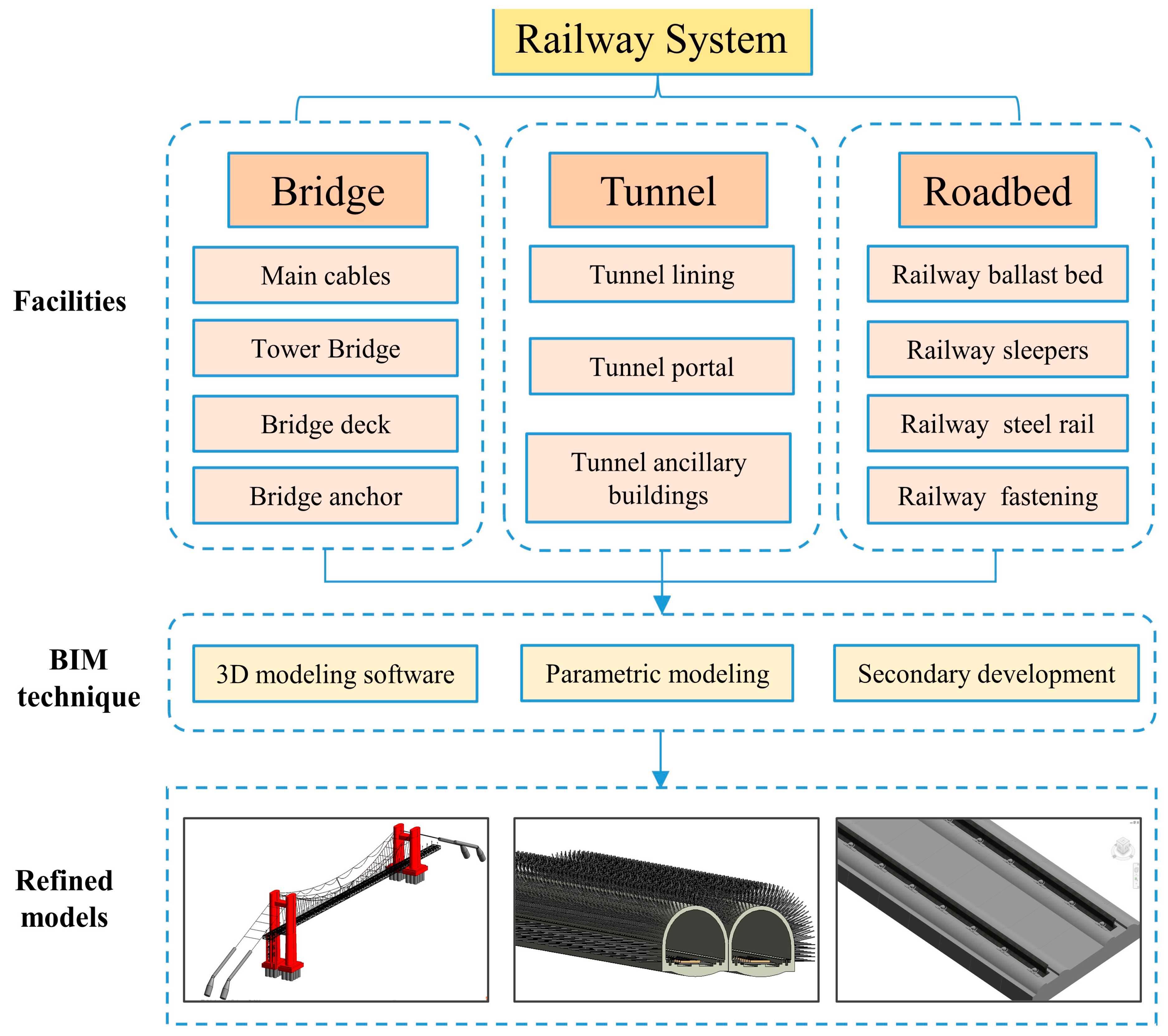
Figure 2. Process flow of refined BIM modeling for railway facilities.
5.2. Integration of Building Information Modeling+Geographic Information Systems for Quantifying Interactions between Disasters and Facilities
GIS involves surface information as well as data information related to the spatial distribution of geographic elements. Within the area of macro geography, GIS can provide several useful geographic queries and analytical services. GIS has become an essential tool for natural disaster analysis and simulation due to its strong investigation of natural environmental elements in large regions. Figure 3 shows that GIS can effectively simulate the movement process and effect scope of geological hazards. It also shows the characteristics of BIM and . The integration of GIS and BIM can make up for the shortcomings of GIS, such as the incomplete presentation of single-model details. At the same time, it will compensate for shortcomings of BIM such as the effect of the surrounding macro geographical environment not being considered.
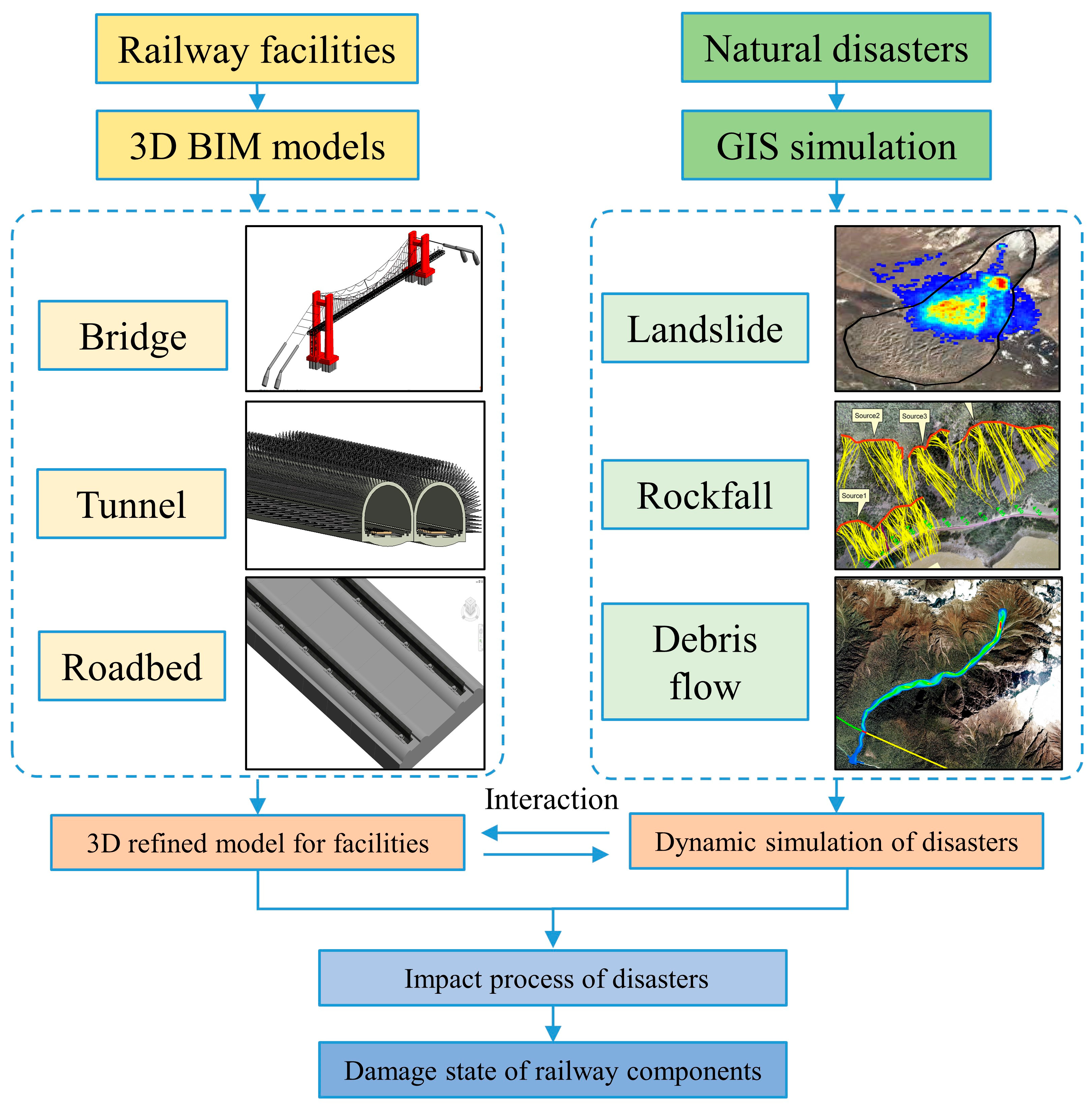
Figure 3. Integration of BIM+GIS for analyzing the interaction between railway facilities and disasters.
5.3. Integration of Building Information Modeling+Geographic Information Systems with New Technology for Considering Coupled Responses of Railway Components to Disasters
New technologies can be applied to the management system of BIM+GIS for coupled responses of railway components to disasters (Figure 4). Based on sensing, recognition, and communication technologies, the Internet of Things (IoT) was regarded as an ideal emerging technology to collect information on numerous indicators in the natural environment or infrastructure system. This real-time collection of information on the operating status of components can not only reflect the extent of damage caused by natural disasters, but also determine which components need to be overhauled in short order, effectively reducing the negative consequences caused by human error. BIM combined with real-time monitoring data from IoT sensors is a powerful framework to make construction and operation more efficient. BIM, GIS, and many kinds of IoT devices can be useful tools in emergency response for disaster risk management.In consideration of the interdependencies between networked infrastructure systems, a BIM, GIS, and domain-specific computational engine (DCE) integrated approach was proposed to assess the vulnerability of infrastructures
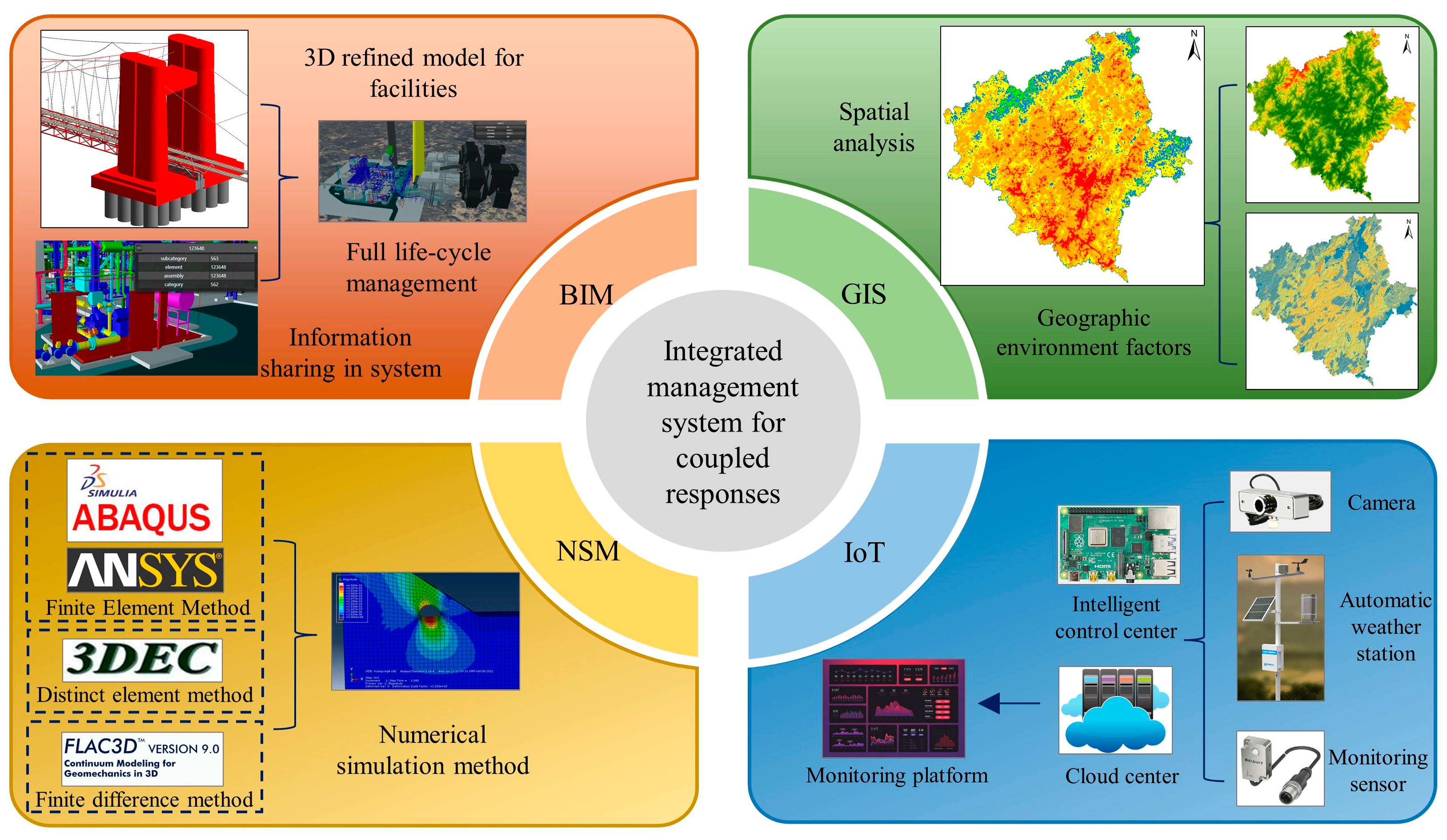
Figure 4. Interaction of BIM+GIS with new technologies for coupled responses of railway components to disasters.
6. Conclusions
This paper reviewed different disaster risk assessments adopted in railway engineering construction, owing to the complicated physical and functional characteristics of its facilities, multiple hazards surrounding their construction, and interdependencies between infrastructure and components. Moreover, the summarization of risk assessments focusing on railway bridges, tunnels, and roadbeds is a crucial factor that should be considered when estimating QRA based on new technologies. Based on an overview of disaster risk assessment for major railway facilities (e.g., bridges, tunnels, and roadbeds), this research highlights the limitations of previous studies and presents three significant challenges for the practical application of TQRA, which are (1) the refined structural modeling of railway facilities, (2) the quantifications of interactions between disasters and railway facilities, and (3) the considerations of coupled responses to disasters of components of railway facilities. These issues severely limit the implementation of TQRA in railway construction and make achieving a refined and accurate disaster risk assessment for railway facilities problematic. Therefore, it is urgent to establish a highly effective and refined QRA approach based on new technology, which will reduce the damage of hazards and allow scientific research on disaster prevention measures. Despite BIM+GIS technology being the current technological development trend for the AEC industry, certain issues should still be addressed. The present cost of digital 3D modeling visualization is expensive, including the precise data required for modeling, labor cost, software and hardware equipment expenditures required for modeling, and so on. In the future, lightweight and practical modeling approaches may be developed. Dynamic monitoring on the status of the surrounding environment and the inside system may be dependent on the IoT. Computer numerical simulation techniques may be employed in analytical computations for complicated structural facilities. Nevertheless, BIM+GIS technology presently lacks a unified interface technique and rules with these new technologies. Future work will concentrate on improving BIM+GIS compatibility with other innovative technologies.

