Your browser does not fully support modern features. Please upgrade for a smoother experience.
Submitted Successfully!
 +1 credit
Thank you for your contribution! You can also upload a video entry or images related to this topic.
For video creation, please contact our Academic Video Service.
| Version | Summary | Created by | Modification | Content Size | Created at | Operation |
|---|---|---|---|---|---|---|
| 1 | Bong-Joo Jang | -- | 2257 | 2023-11-24 09:24:19 | | | |
| 2 | Lindsay Dong | + 2 word(s) | 2259 | 2023-11-27 06:25:19 | | |
Video Upload Options
We provide professional Academic Video Service to translate complex research into visually appealing presentations. Would you like to try it?
Cite
If you have any further questions, please contact Encyclopedia Editorial Office.
Jang, B.; Jung, I. Urban Flood Monitoring Technology. Encyclopedia. Available online: https://encyclopedia.pub/entry/52022 (accessed on 25 June 2026).
Jang B, Jung I. Urban Flood Monitoring Technology. Encyclopedia. Available at: https://encyclopedia.pub/entry/52022. Accessed June 25, 2026.
Jang, Bong-Joo, Intaek Jung. "Urban Flood Monitoring Technology" Encyclopedia, https://encyclopedia.pub/entry/52022 (accessed June 25, 2026).
Jang, B., & Jung, I. (2023, November 24). Urban Flood Monitoring Technology. In Encyclopedia. https://encyclopedia.pub/entry/52022
Jang, Bong-Joo and Intaek Jung. "Urban Flood Monitoring Technology." Encyclopedia. Web. 24 November, 2023.
Copy Citation
Owing to rapid climate change, large-scale floods have occurred yearly in cities worldwide, causing serious damage. General flooding and overflow modeling was performed based on a model that utilizes the flow of water and its geographical characteristics. More detailed geographical data and drainage network information are utilized in urban regions.
disaster response
flood monitoring
urban flood
1. Introduction
Owing to global warming, climate change, including rising ocean temperatures and outbreaks of extremely severe weather, is increasingly occurring worldwide. Large-scale storms such as typhoons and hurricanes occur frequently, whereas incidents of sudden heavy and local torrential rainfall, which were previously uncommon, are increasing exponentially. Consequently, record-breaking rainfalls have been observed in major cities with high population densities worldwide, resulting in severe casualties. In particular, during the summer of 2020 in South Korea, the longest rainy season in history (54.3 d) was recorded, and the national average precipitation during the rainy season was 687 mm, which is nearly twice the average during the same period in different years [1]. Numerous disasters have occurred; in particular, flood damage during the summer worsened as Typhoons Maysak and Haishen hit the Korean Peninsula. At least 50 people were killed or missing [2], and severe damage occurred as rivers flooded and banks were lost in major basins throughout Korea, including the tributaries of the Hantangang, Seomjingang, Hapcheon Hwanggang, and Nakdonggang rivers [3][4]. Furthermore, damage of various magnitudes has been reported across the country. To prevent flood disasters due to climate change, many countries or cities have introduced early warning systems; however, the scale and frequency of damage from flood disasters are sharply increasing globally.
Rapidly developing cities often face difficulties in expanding their drainage facilities despite the frequent heavy rainfall every year, thus experiencing severe damage from inundation. In 2020, three people died in an underpass in Choryang-dong, Busan, because of flooding [5]. In August 2022, a family of three living in a semi-underground housing unit in Sillim-dong, Seoul, was killed owing to flooding caused by heavy rainfall; further, nine people died in an underground parking lot in Indeok-dong, Pohang, which was suddenly flooded by rainfall as Typhoon Hinnamnor hit Korea in September 2022 [6]. These incidents prove that flood damage induced by heavy rainfall can occur in rural areas, river basins, and urban areas.
In particular, the risk of flooding in cities is high because of the fast water flow on well-paved roads or in residential and living areas can cause people to fall or drift away easily, even at a low water level, owing to the lack of obstacles that can reduce the water velocity. Furthermore, rainwater overflowing from drainpipes does not permeate the ground, and instead, flows into the lowlands, thus causing sudden flooding. The probability of people being isolated owing to the characteristics of buildings or complex urban structures is high, even when the flood level is low.
2. Urban Flood Management
The Han River Flood Control Office, under the supervision of the Ministry of Environment [7], intensively monitors national streams and regions with high population densities. The Han River Flood Control Office established a flood-season response system to forecast floods, manage quality, and propagate forecast information before the occurrence of damage. The Han River Flood Control Office monitors major rivers and streams prone to flooding in real time, thus establishing a more effective proactive response system.
Recently, several studies have investigated methods for determining flood risk by employing ML [8][9][10][11]. Park and Kim [8] built an artificial intelligence (AI) model that utilized recurrent neural networks to predict river flooding by measuring the water level at two upstream points. They applied an AI model to predict the water level of rivers; however, the dependence on the performance of a water level measurement instrument is extremely high, and its applicability to real-time warning notification systems for sudden flooding is yet to be validated.
Another study utilized a hydraulic model to calibrate and validate previous flood events to estimate the appropriate roughness coefficient for various flood discharge conditions. A method was established to extrapolate a water level–flow velocity curve by adopting a calibrated and validated model [12]. This method estimates the unmeasured sections by utilizing extrapolations when the flow velocity measurements have missing values. Therefore, this method is limited in terms of the immediate response to sudden floods caused by local torrential rainfall.
As mentioned earlier, national rivers and major cities with water basins or streams have well-established flood forecasting or warning systems, which allow for quick, responsive actions to secure the optimal time for evacuation in urgent situations and prompt recovery through national resources. However, in the case of inundating lowlands or road culverts in cities, the technology applied to rivers cannot be readily utilized in complex urban environments.
Guo et al. [12] investigated various river flooding models for predicting urban flooding. When a river flooding dynamic model is applied to urban flooding and inundation, several numerical issues arise due to the representation of urban terrain, processing method of urban river water, calculation efficiency, and complicated environmental characteristics. Xia et al. [13] introduced a numerical system to model the flow of river flooding on complicated ground terrain to maintain numerical stability and prediction accuracy. Unlike common river basins, urban regions comprise complicated terrain and underground infrastructures, significantly influencing urban flooding. To overcome this problem, a porosity-based shallow water equation (SWE) model is proposed to generalize the effects of high-density buildings within a city. This model focuses on numerical analysis to solve the urban flooding dynamics caused by the water inflow of rivers around cities rather than on the direct influence of heavy rains. Hence, the practical application of this model to urban flooding caused by heavy downpours is challenging.
Glenis et al. [14] proposed a drainage simulation module and a two-dimensional SWE model for major buildings and city infrastructure based on a high-resolution digital elevation model (DEM). Owing to the increased calculation complexity of street-level or meter-scale high-resolution models, various technologies, such as graphics processing units, distributed processing, and parallel algorithms, are required to improve speed.
Despite such attempts, considering all the details of urban environments that may influence flooding caused by heavy rain or overflows remains challenging because urban environments experience rapid transformation. Accordingly, their reliability and efficiency require improvement considering the development of currently available urban flooding models. As mentioned earlier, urban environments have complex underlying surface characteristics, and abrupt changes occur when applying the model because of the nature of cities. Therefore, most numerical models often employ empirical equations that lack stability and accuracy or directly utilize simplified methods.
To reduce the risk of sudden urban flooding caused by heavy downpours, a novel urban flooding prediction model must be developed based on direct and immediate flood-monitoring technology with high accuracy, and the data obtained from such technology should be utilized rather than relying on previous model-based flood-risk-judgment and -prediction technologies.
3. Urban Flood-Monitoring Technology
As previously explained, general flooding and overflow modeling was performed based on a model that utilizes the flow of water and its geographical characteristics. More detailed geographical data and drainage network information are utilized in urban regions.
Because urban flooding mainly results from heavy rain, the amount of rainfall is utilized as an input parameter when developing flood prediction models. The amount of rainfall was computed using a rain gauge, weather radar, and satellite images and was applied as the representative rainfall value in each domain of the geographical model.
Elkhrachy [15] applied an ML regression algorithm that utilized several remote sensing datasets, including those from the Sentinel-1 and Sentinel-2 satellites, and a digital surface model to detect unexpected flooding. The flood water depth was estimated based on ML by detecting the edges and key point features utilizing remote sensing SAR images. When various ML techniques were applied in Cairo, Egypt, the RMSE accuracy ranged from 0.18 to 0.22 m at a depth of less than 1 m. However, the utilization of macroscopic methods based on satellite images and ML results in less accurate observations and predictions in urban environments, which are complicated and change frequently. This technique is also based on a flood model explained in the previous section; thus, it cannot be practically applied as a direct monitoring and warning method in flood-prone areas in cities.
To reduce flood damage that occurs suddenly in cities with high population density and floating populations, the most accurate method is to directly monitor flooding for sites with a high possibility of flooding. Urban flood-monitoring equipment can be categorized into contact and non-contact types depending on whether the equipment is in contact with water. The contact-type equipment, which is most commonly utilized, includes float, reed, pressure, and bubble types. Recently, non-contact equipment has been utilized, including sound waves, ultrasonic waves, radar, LED elements, and closed-circuit television (CCTV) footage. Table 1 presents detailed descriptions of the various types of water meters [16].
Table 1. Various types of water meters according to operation principle.
| Division | Type | Description |
|---|---|---|
| Direct reading | Staff gauge | Water level readings indicated by a staff gauge |
| Float | Float | Water level read by the flute in line with buoyancy |
| Reed switch | Reed contacts utilized by the buzzer | |
| Pressure | Differential pressure | Atmospheric pressure utilizing differential pressure measurement |
| Air purge | Air pressure utilization | |
| Electronic | Electrostatic capacity | Capacitance measurement utilizing the dielectric constant of the aforementioned liquid |
| Electrode | Electrical conductivity measured by utilizing the electrodes | |
| Ultrasonic | Ultrasonic wave | Ultrasonic transit time measurement |
| Sound wave | Transmission time measurement of the sound wave | |
| Radiation | Irradiation | Utilization of radiation-reflected waves |
| Transmission | Radiation transmittance measurement | |
| Microwave | Transmission propagation time measurement of the microwave | |
| Laser | Transmission time difference measurement of the laser | |
| Radar | Echo time difference measurements of radar signals | |
Conventional non-contact-type water level gauges/velocimeters are mostly developed for installation in rivers or dams with high flow volumes; thus, they are difficult to install in urban ecological streams, roads, and lowlands that are exposed to interference caused by changes in the surrounding environment. Conventional contact-type water level gauges/velocimeters result in poor management efficiency if installed and operated in places that do not often flood or require additional infrastructure, and cannot be relocated easily if installed at urban drainage facilities.
Surface image velocimeters (SIVs) involve the installation of a surveillance camera at rivers, and the computation and calibration/validation of the moving speed of a tracking particle by setting a reference point in the images and letting the tracking particle flow in the absence of rainfall [17]. SIVs are sensitive to changes in the environment of rivers, such as illuminance and shade, and entail increased observation errors based on the assumption that the river surface undergoes relatively few changes. Furthermore, this equipment cannot be utilized in dry urban areas.
Owing to the significant evolution in computational speed and deep learning technology since 2010, studies on urban flooding utilizing non-contact methods, such as CCTV footage, have been conducted [18][19][20][21][22]. Qiao et al. [19] proposed a deep learning-based (YOLOv5s and convolutional neural network (CNN)) method to measure the water level to resolve the problem of poor scene adaptability and weak robustness, which is a drawback of conventional water level gauge reading methods based on images. However, this method is ineffective in places without rivers because it involves reading the number of water level indicators in a river.
Lopez-Fuentes et al. [20] proposed a multimodal deep learning model to detect flooding in social media posts; this model comprised a CNN, which extracted visual features and a bi-directional long short-term memory network, which extracted semantic features from text metadata. Han et al. [21] proposed a puddle detection method based on reflection attention units and a fully convolutional network. Sarp et al. [22] proposed an automatic overflow detection and segmentation method utilizing a Mask-R-CNN, a type of region-based CNN, for object detection and semantic segmentation. Most deep learning algorithms that employ CCTV footage are aimed at crime prevention and security; thus, they cannot be effectively utilized to detect rainwater flowing into lowlands. Other issues, such as glare, flare, and ghosting in cameras, may result in poor resolution. Heavy rain and trees may block the view, or image quality can be significantly degraded at night, which will also cause difficulty in determining flooding.
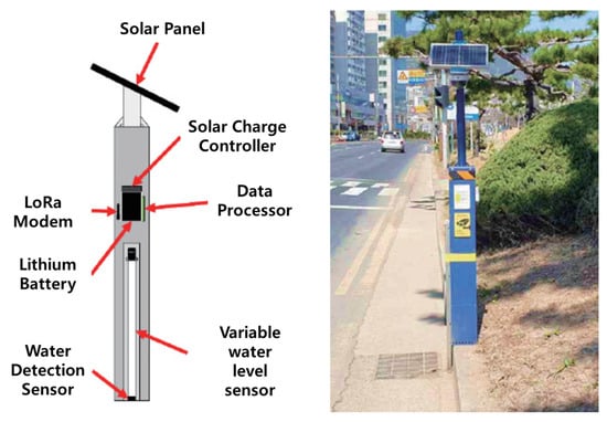
To explain the differentiation of the proposed technology in more detail, the urban flooding sensor currently in operation in the Republic of Korea [23] is shown as a conceptual diagram and an example of an actual installation site in Figure 1.
Figure 1. Concept and installation example of urban flooding sensor currently in operation in Republic of Korea [23].
The urban flooding sensor shown in Figure 1 is a technology developed and currently in operation by the National Disaster and Safety Research Institute. Much research is being done to use the data observed from these sensors to determine the presence or absence of flooding in a specific location and use it as the basis for an urban flood model. However, as can be seen from the field-installed sensor device in Figure 1, this method obtains a response by directly exposing the sensor to water, so the observation range and installation range for flooding are extremely limited. In addition, because the structure of the sensor requires direct contact with water, there is a high possibility of errors due to trash or floating objects, so continuous maintenance is essential. Additionally, because it must be installed in the form of a pole, there are administrative and legal restrictions on the installation of public infrastructure. Crucially, it is difficult to install near urban rivers where inland water flooding is likely to occur. So, when a river floods and sensors detect flooding, the risk level may already be high. In addition, because it cannot detect the flow rate or speed of flood water, it is difficult to expect that it will be of much use in responding to and predicting water disasters.
References
- Monthly Climate Analysis Information. August 2020. Available online: http://www.kma.go.kr/download_02/ellinonewsletter_2020_08.pdf (accessed on 4 October 2023).
- Article Dated. 9 August 2020. Available online: https://www.etoday.co.kr/news/view/1927331 (accessed on 6 October 2023).
- Article Dated. 5 August 2020. Available online: http://www.hani.co.kr/arti/area/gangwon/956584.html (accessed on 6 October 2023).
- Article Dated. 5 August 2020. Available online: http://news.khan.co.kr/kh_news/khan_art_view.html?artid=202008081620001 (accessed on 6 October 2023).
- Article Dated. 20 July 2023. Available online: http://www.bbc.com/korean/news-66224398 (accessed on 30 October 2023).
- Article Dated. 7 September 2022. Available online: https://www.ntoday.co.kr/news/articleView.html?idxno=93654 (accessed on 30 October 2023).
- Realtime River Monitoring Data. 2023. Available online: http://www.hrfco.go.kr/sumun/waterlevelList.do# (accessed on 23 October 2023).
- Park, S.H.; Kim, H.J. Design of Artificial Intelligence Water Level Prediction System for Prediction of River Flood. J. Korea Inst. Inf. Commun. Eng. 2020, 24, 198–203.
- Zarei, M.; Bozorg-Haddad, O.; Baghban, S.; Delpasand, N.; Goharian, E.; Loáiciga, H.A. Machine-learning algorithms for forecast-informed reservoir operation (FIRO) to reduce flood damages. Sci. Rep. 2021, 11, 24295.
- Mateo-Garcia, G.; Veitch-Michaelis, J.; Smith, L.; Vlad Oprea, S.; Schumann, G.; Gal, Y.; Baydin, A.G.; Backes, D. Towards global flood mapping onboard low cost satellites with machine learning. Sci. Rep. 2021, 11, 7249.
- Shafizadeh-Moghadam, H.; Valavi, R.; Shahabi, H.; Chapi, K.; Shirzadi, A. Novel forecasting approaches using combination of machine learning and statistical models for flood susceptibility mapping. J. Environ. Manag. 2018, 217, 1–11.
- Guo, K.; Guan, M.; Yu, D. Urban surface water flood modelling—A comprehensive review of current models and future challenges. Hydrol. Earth Syst. Sci. 2021, 25, 2843–2860.
- Xia, X.; Liang, Q.; Ming, X.; Hou, J. An efficient and stable hydrodynamic model with novel source term discretization schemes for overland flow and flood simulations. Water Resour. Res. 2017, 53, 3730–3759.
- Glenis, V.; Kutija, V.; Kilsby, C.G. A fully hydrodynamic urban flood modelling system representing buildings, green space and interventions. Environ. Model. Softw. 2018, 109, 272–292.
- Elkhrachy, I. Flash Flood Water Depth Estimation Using SAR Images, Digital Elevation Models, and Machine Learning Algorithms. Remote Sens. 2022, 14, 440.
- Hong, S.T.; Shin, G.W. Development of Portable Calibration System for Non-contact Water Meters. J. Korea Inst. Inf. Commun. Eng. 2016, 20, 1808–1815.
- Kim, Y.S.; Yang, S.K. Error Rate Analysis According to Setting of the Reference Point for Calculating the Flood Runoff that Using Surface Image Velocimeter. J. Environ. Sci. Int. 2016, 25, 799–815.
- Korea Institute of Civil Engineering and Building Technology. Demonstration Project of Inundation Monitoring System for Inland Inundation Preparedness; KICT Research Report; Korea Institute of Civil Engineering and Building Technology: Goyang-si, Republic of Korea, 2020.
- Qiao, G.; Yang, M.; Wang, H. A Water Level Measurement Approach Based on YOLOv5s. Sensors 2022, 22, 3714.
- Lopez-Fuentes, L.; van de Weijer, J.; Bolanos, M.; Skinnemoen, H. Multi-modal Deep Learning Approach for Flood Detection. In Proceedings of the MediaEval’17, Dublin, Ireland, 13–15 September 2017.
- Han, X.; Nguyen, C.; You, S.; Lu, J. Single Image Water Hazard Detection using FCN with Reflection Attention Units. In Proceedings of the ECCV (European Conference on Computer Vision), Munich, Germany, 8–14 September 2018; pp. 105–121.
- Sarp, S.; Kuzlu, M.; Cetin, M.; Sazara, C.; Guler, O. Detecting Floodwater on Roadways from Image Data Using Mask-R-CNN. In Proceedings of the 2020 International Conference on INnovations in Intelligent SysTems and Applications (INISTA), Novi Sad, Serbia, 24–26 August 2020.
- Moon, H.; Kang, H.; Lee, H.; Hwang, G. Development of Urban Flooding Sensor and its utilization method. J. Korea Water Resour. Assoc. Water Future 2020, 53, 55–59.
More
Information
Contributors
MDPI registered users' name will be linked to their SciProfiles pages. To register with us, please refer to https://encyclopedia.pub/register
:
View Times:
721
Revisions:
2 times
(View History)
Update Date:
27 Nov 2023
Table of Contents


Notice
You are not a member of the advisory board for this topic. If you want to update advisory board member profile, please contact office@encyclopedia.pub.
OK
Confirm
Only members of the Encyclopedia advisory board for this topic are allowed to note entries. Would you like to become an advisory board member of the Encyclopedia?
Yes
No
${ textCharacter }/${ maxCharacter }
Submit
Cancel
Back
Comments
${ item }
|
${ item.createdUser.fullName }
${ item.createdAt }
${ item.vote }
${ item.reply }
Delete
${ reply.createdUser.fullName }
${ reply.createdAt }
${ reply.vote }
Delete
There is no reply to this comment~
${ item.replyTextCharacter }/${ item.replyMaxCharacter }
Submit
Cancel
More
No more~
There is no comment~
${ textCharacter }/${ maxCharacter }
Submit
Cancel
${ selectedItem.replyTextCharacter }/${ selectedItem.replyMaxCharacter }
Submit
Cancel
Confirm
Are you sure to Delete?
Yes
No