Your browser does not fully support modern features. Please upgrade for a smoother experience.
Submitted Successfully!
 +1 credit
Thank you for your contribution! You can also upload a video entry or images related to this topic.
For video creation, please contact our Academic Video Service.
| Version | Summary | Created by | Modification | Content Size | Created at | Operation |
|---|---|---|---|---|---|---|
| 1 | Aleksandar Dimitrijevic | -- | 1044 | 2023-09-06 15:50:05 | | | |
| 2 | Sirius Huang | Meta information modification | 1044 | 2023-09-07 02:55:28 | | |
Video Upload Options
We provide professional Academic Video Service to translate complex research into visually appealing presentations. Would you like to try it?
Cite
If you have any further questions, please contact Encyclopedia Editorial Office.
Dimitrijević, A.; Milosavljević, A.; Rančić, D. Development of Discrete Global Grid Systems. Encyclopedia. Available online: https://encyclopedia.pub/entry/48881 (accessed on 25 June 2026).
Dimitrijević A, Milosavljević A, Rančić D. Development of Discrete Global Grid Systems. Encyclopedia. Available at: https://encyclopedia.pub/entry/48881. Accessed June 25, 2026.
Dimitrijević, Aleksandar, Aleksandar Milosavljević, Dejan Rančić. "Development of Discrete Global Grid Systems" Encyclopedia, https://encyclopedia.pub/entry/48881 (accessed June 25, 2026).
Dimitrijević, A., Milosavljević, A., & Rančić, D. (2023, September 06). Development of Discrete Global Grid Systems. In Encyclopedia. https://encyclopedia.pub/entry/48881
Dimitrijević, Aleksandar, et al. "Development of Discrete Global Grid Systems." Encyclopedia. Web. 06 September, 2023.
Copy Citation
The rapid growth in Earth’s global geospatial data necessitates an efficient system for organizing the data, facilitating data fusion from diverse sources, and promoting interoperability. Mapping the spheroidal surface of the planet presents significant challenges as it involves balancing distortion and splitting the surface into multiple partitions. The distortion decreases as the number of partitions increases, but, at the same time, the complexity of data processing increases since each partition represents a separate dataset and is defined in its own local coordinate system.
discrete global grid system
equidistant cylindrical projection
distortion
1. Introduction
Organizing and referencing geospatial data pose increasingly complex challenges due to the sheer volume and rapid growth of the data collected. For example, the daily influx of high-resolution satellite imagery alone amounts to terabytes of data. It is important to store these data in a format that allows easy access, referencing, sharing, and analysis without frequent re-projections to maintain accuracy.
Addressing these challenges requires the development of a spatial reference frame capable of fusing data from diverse sources into a global mosaic at multiple resolutions. Discrete Global Grid Systems (DGGSs) have emerged as a promising class of such reference frames. They use hierarchical tessellation to partition and address the entire planet without gaps or overlaps. The development of DGGS began in the mid 20th century [1] but only became popular at the turn of the century [2][3][4]. A prominent subclass of DGGSs are Geodesic DGGSs (GDGGSs) [4], which project the surface of the planet onto the faces of regular or semi-regular circumscribed polyhedra. Commonly used base polyhedra are the five Platonic solids, in particular the hexahedron (cube), while the most common semi-regular polyhedron is the truncated icosahedron. The appearance of unfolded regular polyhedra, the number and shape of faces, and the way they partition Earth’s surface can be observed in Figure 1.
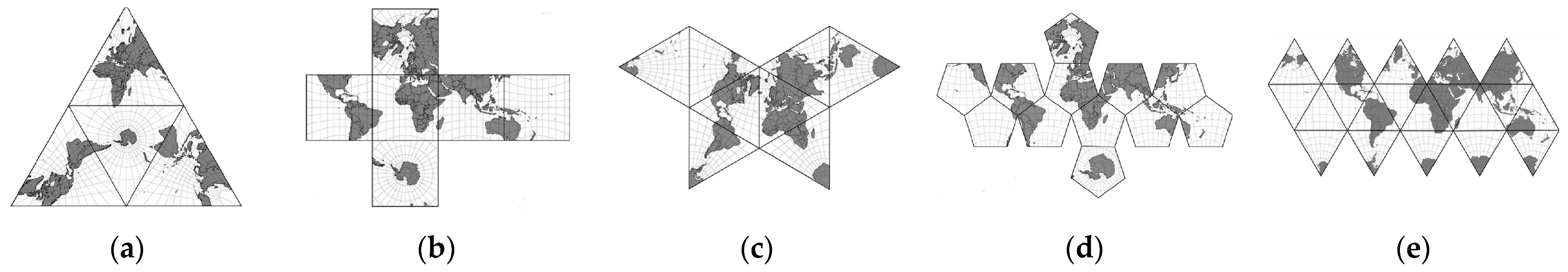
Figure 1. Unfolded regular polyhedra used in GDDGSs: (a) tetrahedron; (b) hexahedron; (c) octahedron; (d) dodecahedron; (e) icosahedron.
While increasing the number of faces in a polyhedron improves its approximation of a spherical surface, it introduces complications when merging adjacent partitions due to separate coordinate systems and datasets. Moreover, memory and CPU consumption increase with the number of partitions in systems handling streaming geospatial data, like out-of-core planet-scale terrain rendering applications [5]. Therefore, minimizing the number of partitions becomes desirable.
2. Development of Discrete Global Grid Systems (DGGSs)
The need to develop a system for organizing global geospatial data is not new. One of the first studies on the feasibility of implementing the Earth Data Base System [6] was conducted in the early 1970s for the needs of the US Navy. The system was based on Quadrilateralized Spherical Cube (QSC), one of the first hexahedral projections implemented on digital computers. The proposed system was soon modified [7], and, in the following years, it was also used as part of the Cosmic Background Explorer (COBE) project at NASA.
Due to the regular and uniform structure of the grid consisting of square cells, consistency with the Cartesian coordinate system, ease of interpolation and extrapolation, and straightforward visualization, hexahedral projections have gained wide popularity and are used in many different fields.
Hierarchical Equal-Area isoLatitude Pixelization (HEALPix) is a class of spherical projections with the property of distributing 12N2 points as uniformly as possible over the surface of the unit sphere [8]. These hybrid projections combine the Lambert cylindrical equal-area projection for the equatorial region with the interrupted Collignon projection for the polar regions. Of this infinite class of projections, only the projection with three base resolution pixel layers between the north and south poles and four equatorial base resolution pixels can be rearranged to a hexahedral projection.
Rotated HEALPix (rHEALPix) [9] is an extension of the HEALPix scheme that introduces rotation capabilities, is better adapted to standards, and inherently combines polar triangles into quadratic partitions. Further, rHEALPix has found wide application in organizing global geospatial data [9][10][11]. All the previously mentioned projections are equal-area, but with significant angular distortions and even discontinuities. Due to their simpler implementation and relatively good balance between angular and areal distortion, many hexahedral projections also find application in computer graphics [12] and, in particular, in planet-scale terrain visualization [13]. Among the best known are Adjusted Spherical Cube (ASC) [14], Continuous Cube Mapping (CCM) [15], and Cartesian Spherical Cube (CSC) [16].
In addition to polyhedral projections, the UTM and Equi7 grid systems and equidistant cylindrical projection, also known as plate carree, are commonly used today. Equidistant cylindrical projection, despite its considerable distortion, is still widely used to organize global data because it is simple, has a regular grid structure, and can cover the entire world in a single rectangular map. The Universal Transverse Mercator (UTM) grid system, on the other hand, divides Earth into 60 zones, which reduces distortion but limits its application to medium-scale mapping. Equi7 [17] is an example of a compromise that combines seven continental grids based on equidistant azimuthal projections.
The expansion of the system for organizing and referencing global geospatial data occurs at the turn of the century, when the first classifications appear and the term Discrete Global Grid System (DGGS) is introduced for a very significant class of such systems. The importance of DGGSs is also reflected in the fact that the Open Geospatial Consortium (OGC) established the DGGS Standard and Domain Working Groups to support the standardization of these systems. In 2017, the OGC published the first version of the DGGS Abstract Specification [18]. The standardization process continued, resulting in a formal specification defined by ISO 19170-1:2021 standard [19] and a revised version of the OGC Abstract Specification [20]. The popularity of DGGS has also increased due to numerous open source implementations [21].
A recent trend in geospatial data processing involves the implementation of datacubes based on DGGSs [22], enabling efficient management of big data workflows. DGGSs, as a standardized representation of Earth, provide the foundational platform for Digital Earth [23]. Digital Earth is a concept that aims to create an interactive digital replica of the entire planet, fostering a shared understanding of the relationships between the physical and natural environment and society [24].
The design of GDGGSs is characterized by five fundamental elements [4]:
- A regular base polyhedron;
- The orientation of the base polyhedron with respect to the planet;
- A hierarchical spatial partitioning of the polyhedron faces;
- The mapping of a spherical or ellipsoidal surface to polyhedral faces and vice versa;
- Methods for indexing and addressing cells.
References
- Vestine, E.H.; Sibley, W.L.; Kern, J.W.; Carlstedt, J.L. Integral and Spherical-Harmonic Analyses of the Geomagnetic Field for 1955.0, Part 2. J. Geomagn. Geoelectr. 1963, 15, 73–89.
- Kimerling, A.J.; Sahr, K.; White, D.; Song, L. Comparing Geometrical Properties of Global Grids. Cartogr. Geogr. Inf. Sci. 1999, 26, 271–288.
- Alborzi, H.; Samet, H. Augmenting SAND with a spherical data model. In Proceedings of the First International Conference on Discrete Global Grids, Santa Barbara, CA, USA, 26–28 March 2000.
- Sahr, K.; White, D.; Kimerling, A.J. Geodesic Discrete Global Grid Systems. Cartogr. Geogr. Inf. Sci. 2003, 30, 121–134.
- Dimitrijević, A.; Rančić, D. Ellipsoidal Clipmaps—A planet-sized terrain rendering algorithm. Comput. Graph. 2015, 52, 43–61.
- Chan, F.K.; O’Neill, E.M. Feasibility study of a quadrilateralized spherical cube earth data base. In Technology Report EPRF 2-75 (CSC); Naval Environmental Prediction Research Facility: Monterey, CA, USA, 1975.
- O’Neill, E.M.; Laubscher, R.E. Extended studies of a quadrilateralized spherical cube earth data base. In Technology Report NEPRF 3-76 (CSC); Naval Environmental Prediction Research Facility: Monterey, CA, USA, 1976.
- Górski, K.M.; Hivon, E.; Banday, A.J.; Wandelt, B.D.; Hansen, F.K.; Reinecke, M.; Bartelmann, M. HEALPix: A framework for high-resolution discretization and fast analysis of data distributed on the sphere. Astrophys. J. (ApJ) 2005, 622, 759–771.
- Gibb, R.G. The rHEALPix Discrete Global Grid System. IOP Conf. Ser. Earth Environ. Sci. 2016, 34, 012012.
- Bowater, D.; Stefanakis, E. The rHEALPix Discrete Global Grid System: Considerations for Canada. Geomatica 2018, 72, 27–37.
- Béjar, R.; Lacasta, J.; Lopez-Pellicer, F.J.; Nogueras-Iso, J. Discrete Global Grid Systems with quadrangular cells as reference frameworks for the current generation of Earth observation data cubes. Environ. Model. Softw. 2023, 162, 105656.
- Lambers, M. Survey of Cube Mapping Methods in Interactive Computer Graphics. Vis. Comput. 2020, 36, 1043–1051.
- Dimitrijević, A.; Lambers, M.; Rančić, D. Comparison of Spherical Cube Map Projections Used in Planet-Sized Terrain Rendering. Facta Univ. Ser. Math. Inform. 2016, 31, 259–297.
- Lerbour, R.; Marvie, J.-E.; Gautron, P. Adaptive real-time rendering of planetary terrains. In Proceedings of the Full Papers Proceedings: 18th International Conference in Central Europe on Computer Graphics, Visualization and Computer Vision, Plzen, Czech Republic, 1–4 February 2010; pp. 89–96.
- Grimm, C.; Niebruegge, B. Continuous Cube Mapping. J. Graph. GPU Game Tools 2007, 12, 25–34.
- Nowell, P. Mapping a Cube to a Sphere. Available online: http://mathproofs.blogspot.de/2005/07/mapping-cube-to-sphere.html (accessed on 24 May 2023).
- Bauer-Marschallinger, B.; Sabel, D.; Wagner, W. Optimisation of global grids for high-resolution remote sensing data. Comput. Geosci. 2014, 72, 84–93.
- Purss, M. (Ed.) Topic 21: Discrete Global Grid Systems Abstract Specification, OGC 15-104r5. 2017. Available online: http://docs.ogc.org/as/15-104r5/15-104r5.html (accessed on 24 May 2023).
- ISO 19170-1:2021; Geographic Information—Discrete Global Grid Systems Specifications—Part 1: Core Reference System and Operations, and Equal Area Earth Reference System. 2021. Available online: https://www.iso.org/standard/32588.html (accessed on 24 May 2023).
- Gibb, R. (Ed.) Topic 21—Discrete Global Grid Systems—Part 1 Core Reference system and Operations and Equal Area Earth Reference System, OGC 20-040r3. 2021. Available online: https://docs.ogc.org/as/20-040r3/20-040r3.html (accessed on 24 May 2023).
- Kmoch, A.; Matsibora, O.; Vasilyev, I.; Uuemaa, E. Applied open-source Discrete Global Grid Systems. AGILE GIScience Ser. 2022, 3, 41.
- Purss, M.B.J.; Peterson, P.R.; Strobl, P.; Dow, C.; Sabeur, Z.A.; Gibb, R.G.; Ben, J. Datacubes: A Discrete Global Grid Systems Perspective. Cartogr. Int. J. Geogr. Inf. Geovisualization 2019, 54, 63–71.
- Alderson, T.; Purss, M.; Du, X.; Mahdavi-Amiri, A.; Samavati, F. Digital Earth Platforms. In Manual of Digital Earth, 1st ed.; Guo, H., Goodchild, M.F., Annoni, A., Eds.; Springer: Singapore, 2020; pp. 25–54.
- Digital Earth. Available online: https://joint-research-centre.ec.europa.eu/scientific-activities-z/digital-earth_en (accessed on 24 May 2023).
More
Information
Subjects:
Computer Science, Information Systems
Contributors
MDPI registered users' name will be linked to their SciProfiles pages. To register with us, please refer to https://encyclopedia.pub/register
:
View Times:
708
Revisions:
2 times
(View History)
Update Date:
07 Sep 2023
Table of Contents


Notice
You are not a member of the advisory board for this topic. If you want to update advisory board member profile, please contact office@encyclopedia.pub.
OK
Confirm
Only members of the Encyclopedia advisory board for this topic are allowed to note entries. Would you like to become an advisory board member of the Encyclopedia?
Yes
No
${ textCharacter }/${ maxCharacter }
Submit
Cancel
Back
Comments
${ item }
|
${ item.createdUser.fullName }
${ item.createdAt }
${ item.vote }
${ item.reply }
Delete
${ reply.createdUser.fullName }
${ reply.createdAt }
${ reply.vote }
Delete
There is no reply to this comment~
${ item.replyTextCharacter }/${ item.replyMaxCharacter }
Submit
Cancel
More
No more~
There is no comment~
${ textCharacter }/${ maxCharacter }
Submit
Cancel
${ selectedItem.replyTextCharacter }/${ selectedItem.replyMaxCharacter }
Submit
Cancel
Confirm
Are you sure to Delete?
Yes
No