Submitted Successfully!
To reward your contribution, here is a gift for you: A free trial for our video production service.
Thank you for your contribution! You can also upload a video entry or images related to this topic.
Version Summary Created by Modification Content Size Created at Operation
1 -- 1568 2023-01-04 11:55:34 |
2 update layout Meta information modification 1568 2023-01-05 02:39:11 | |
3 update layout -32 word(s) 1536 2023-01-06 08:00:34 |

Video Upload Options

Do you have a full video?

Confirm

Are you sure to Delete?
Cite
If you have any further questions, please contact Encyclopedia Editorial Office.
Lisowski, J.A. Artificial Intelligence in Safe Marine Environment. Encyclopedia. Available online: https://encyclopedia.pub/entry/39726 (accessed on 15 May 2024).
Lisowski JA. Artificial Intelligence in Safe Marine Environment. Encyclopedia. Available at: https://encyclopedia.pub/entry/39726. Accessed May 15, 2024.
Lisowski, Józef Andrzej. "Artificial Intelligence in Safe Marine Environment" Encyclopedia, https://encyclopedia.pub/entry/39726 (accessed May 15, 2024).
Lisowski, J.A. (2023, January 04). Artificial Intelligence in Safe Marine Environment. In Encyclopedia. https://encyclopedia.pub/entry/39726
Lisowski, Józef Andrzej. "Artificial Intelligence in Safe Marine Environment." Encyclopedia. Web. 04 January, 2023.
Artificial Intelligence in Safe Marine Environment
Edit

This research presents a combination of remote sensing, an artificial neural network, and game theory to synthesize a system for safe ship traffic management at sea. Serial data transmission from the ARPA anti-collision radar system are used to enable computer support of the navigator’s maneuvering decisions in situations where a large number of ships must be passed.

environmental remote sensing neural network computer simulation

1. Introduction

The ARPA anti-collision system allows for the automatic tracking of detected echoes from ships and their follow-up and generates alarms in dangerous situations. The ARPA device calculates the time to the nearest TCPA (time to closest point of approach) and the closest distance for each tracked vessel DCPA (distance of point of approach), and then compares the obtained values with the distance and approach time limits set by the navigator. When the distance and time-to-proxim values exceed the set limits, a DANGEROUS TARGET alarm occurs. Then, the TRIAL MANEUVER can be simulated using the ARPA device. This process consists of checking the effects of the designed anti-collision maneuver under thirty-fold acceleration. The ARPA device serves as a computer-aided decision support tool for the navigator, and thus contributes to increasing the safety of navigation [1].
However, the basic structure of the ARPA system does not take into account many factors affecting the safety of navigation, such as the subjectivity of navigators in making final maneuvering decisions and the uncertainty of real navigational situations resulting from the impacts of disturbances. Therefore, there is a need to supplement this system with appropriate computer-assisted navigator software.
The implementation of anti-collision maneuvers must be subordinated to the requirements of COLREGs [2][3][4][5][6].
Consequently, among the many possibilities for describing the anti-collision process, optimal control models with neural constraints of the process state are the most useful [7][8][9].
The control of such an anti-collision process is greatly facilitated by the use of computer decision support. The works of Pietrzykowski and Wołejsza [10], Ożoga and Montewka [11], and Aylward et al. are devoted to this issue [12].
An analysis of the support methods developed so far using evolutionary and particle swarm algorithms shows that these methods do not take into account human subjectivity and the properties of navigational uncertainty in real anti-collision problems for the ship, which can be represented by an artificial neural network [13][14][15][16][17]. The factors of human subjectivity and the indefiniteness of the environment can be presented and described using the methods of artificial intelligence and game theory.
Figure 1 presents a graphical presentation of the operation of the navigator support system that takes into account both the subjectivity of the situation assessment and the uncertainty of its development, leading to a possible collision of ships.
Figure 1. Graphical presentation of the functioning of the navigator support system tested on a research and training vessel r/v HORYZONT II in a real marine environment in the Skagerrak–Kattegat Straits: V, ψ is the speed and course of one’s own ship; Vj, ψj is the encountered j ship speed and course; Dj, Nj is the distance and bearing to j the encountered ship; D is the safe passing distance for ships in real conditions of visibility at sea; Djmin, Tjmin is the distance and time to the closest approach of the ships.

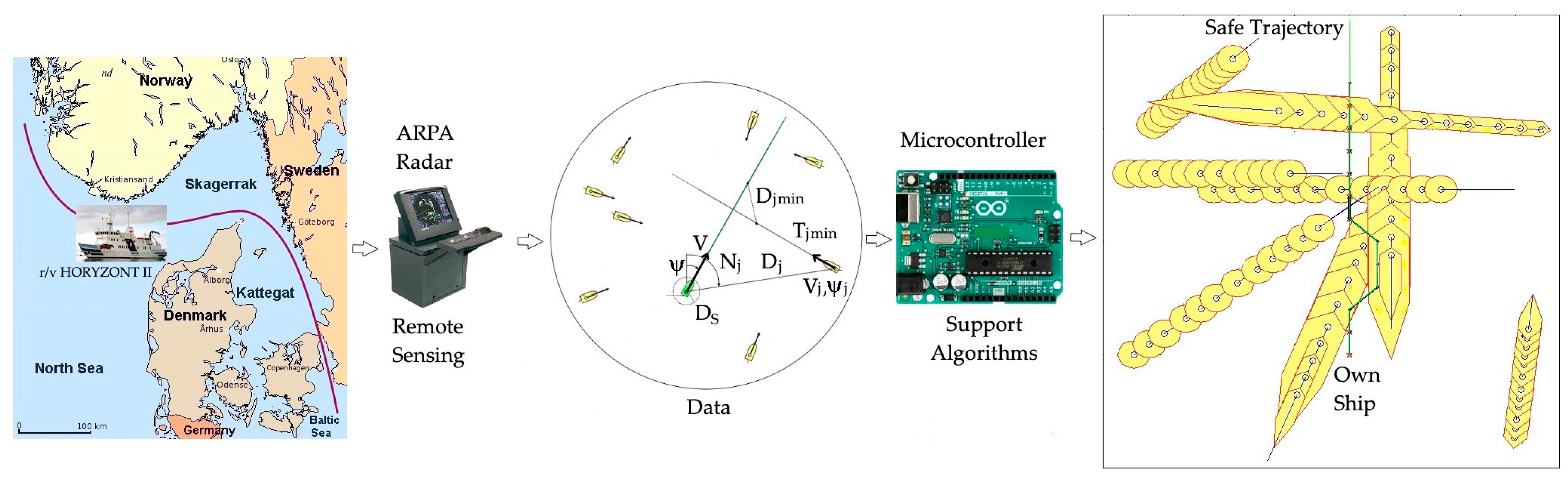
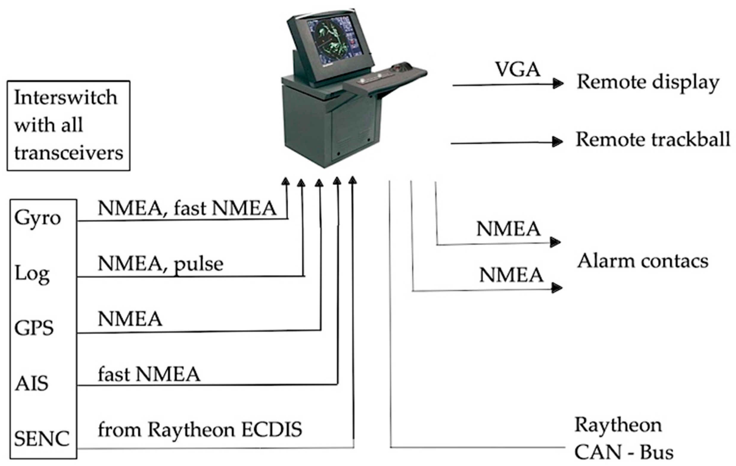
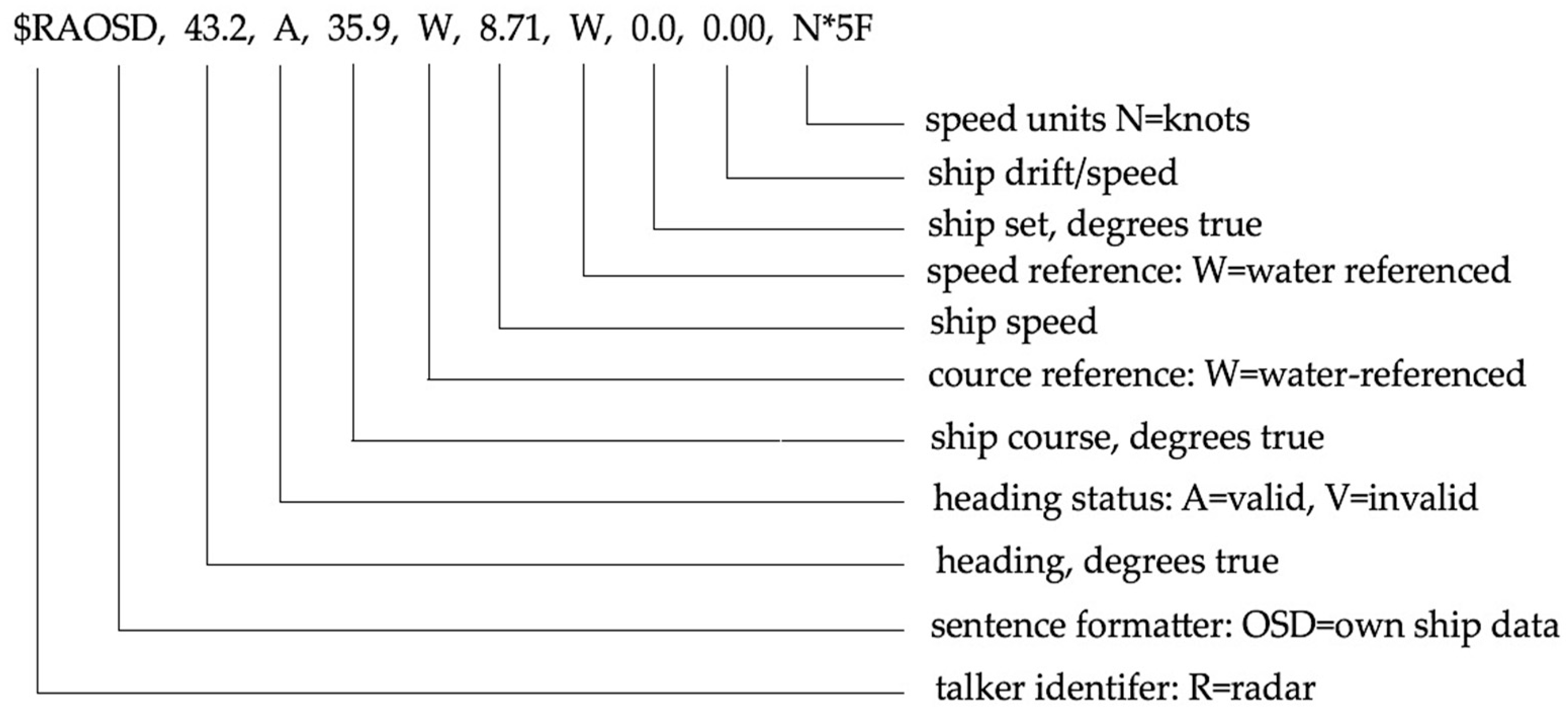
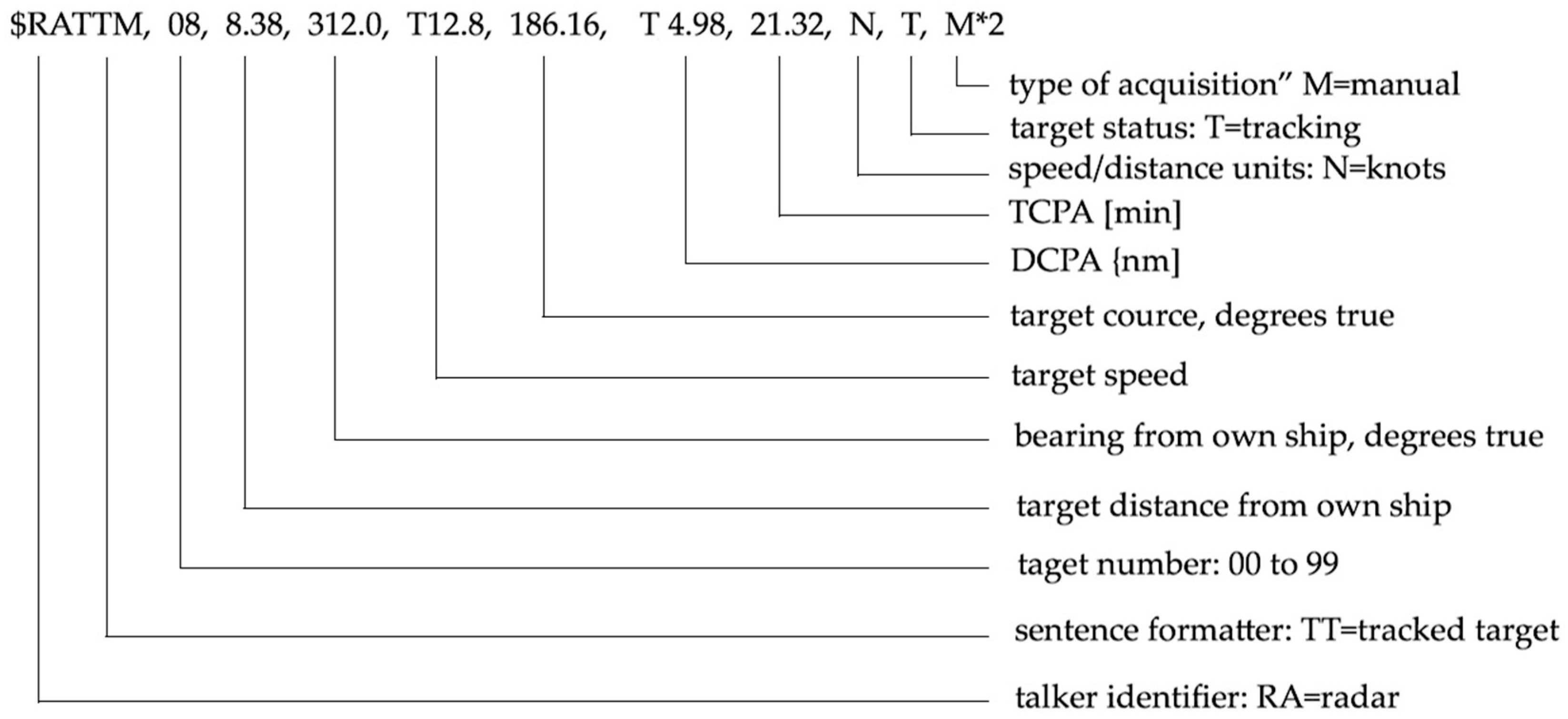
2. Marine Environment Remote Sensing Using a Radar ARPA System

The task of the navigator’s decision support system is to present a maneuver proposal determined as a result of anti-collision calculations. These calculations are carried out through specific algorithms for determining the safe trajectory of the ship based on input data describing the current navigational situation.
The data for the calculations are the data of one’s own ship, such as the actual course ψ of the ship and the actual speed V of the ship, as well as data on the ships encountered, such as the j-th ship distance Dj, bearing Nj, speed Vj, course ψj, and quantities characterizing the moment of the shortest distance between ships: Djmin = DCPAj, which is the Distance of the Closest Point of Approach, and Tjmin = TCPAj, which is the closest point of approach.
The operation of the system consists of transmitting data from the ARPA radar system to the microcontroller, entering this data into the program implementing the selected algorithm, and finally illustrating the calculation results in the form of a safe trajectory for one’s own ship (Figure 2).
Figure 2. Diagram of standard Raytheon Anschutz radar system interfaces.
Data from radar ARPA are downloaded in NMEA 0183 format (IEC 61162-1). Asynchronous serial transmission according to the RS 232 standard is used to transmit these data with a transmission speed of 4800 bods. Here, there are eight bits of data and one stop bit with no parity bit. Before commencing communication, it is necessary to define the above parameters with the help of an application that supports the transmission so that the data transfer process can proceed correctly. The NMEA 0183 standard (IEC 61162-1), in addition to the transmission parameters, also determines the format of the data frame. This standard also defines a set of sentences that can be registered from different devices.
The data needed for the anti-collision calculations performed in the designed navigator decision support system are provided in the form of sentences described by tags, including OSD (one’s own ship data) and TTM (tracked target message). In front of these markers in the sentence there is also an identifier to mark the device from which the data are sent. In the designed system, the data are collected from ARPA Radar Anti-collision (RA) and are, thus, described with the RA symbol (Figure 3 and Figure 4).
Figure 3. The format of the data frame with the sample parameters of one’s own ship.
Figure 4. The format of the data frame containing the sample information about the tracked ship.
The designed system consisted of the ARPA radar system and a microcontroller device that managed data transmission and performed calculations to determine the ship’s safe trajectory in the MATLAB software. To start the application, the MATLAB directory was set to include algorithms that can determine a safe ship trajectory using artificial intelligence methods and then enter the appropriate algorithm shortcut in the command window.
First, the input parameters for the calculations are set, including the time of one trajectory stage, the time of advance for course or speed change maneuvers, the safe distance between ships, and the allowable deviation of the trajectory from the set course, causing the speed to decrease by the indicated percentage level. The above values are entered manually or set to default. The default values are as follows: the duration of one trajectory stage, 1 to 12 min; time to advance the speed or course change maneuver, 0 to 18 min; safe passing distance between ships, 0.1 to 3 nautical miles; and acceptable course deviation at which speed must be reduced, 361 degrees, with speed reduced by 25%.
The next stage includes communication with the ARPA system and downloading the information necessary to determine the ship’s safe trajectory. Sending the signal is preceded by setting the identifier of the communication port. Then, the baud rate is set to 4800 baud. Next, the port for transmission is opened, and the corresponding data frames defined by OSD and the TTM tags are initiated.
The values sent are classified as the necessary parameters to calculate the ship’s safe trajectory and are saved in the required format. After the data transmission is completed, the communication port is closed, and the program is used to calculate the safe trajectory of the ship.
The last stage of the application operation is presenting the calculation results in the form of a safe trajectory of one’s own ship and the value of the optimal time or course deviation after leaving the collision situation.
  1. Artificial Intelligence Methods in the Synthesis of Safe Control Algorithms in a Marine Environment

To ensure safe navigation, ships are required to respect the rules of COLREGs. However, these rules are limited to only two vessels under good conditions and restricted visibility at sea. These rules, moreover, only give recommendations of a general nature and are not able to cover all of the necessary conditions for the actual process [18].

Thus, the actual process of ships passing each other often takes place under conditions of indeterminacy and conflicts with the inexact cooperation of ships in accordance with COLREGs. Therefore, it is advisable to present the process and develop and test, for practical purposes, methods of safe ship control using elements of game theory.

Several studies have indicated that in order to take into account the possible maneuvering strategies of passing ships and their dynamic properties, it is best to use a description of this control process in a differential game model.

For the synthesis of control algorithms, models simplifying the complex differential game model and artificial intelligence models are used. On the basis of such approximate models, appropriate algorithms for computer-aided maneuvering decisions of the navigator under collision situations are synthesized (Table 1).

Table 1. Types of algorithms for determining the ship’s safe trajectory in a collision situation at sea.

Artificial Intelligence Method

Control Synthesis Method

Algorithm

Artificial Neural Network

Dynamic Programming

Dynamic Trajectory DT

Positional Game

Triple Linear Programming

Game Positional Trajectory GPT

Matrix Game

Dual Linear Programming

Game Risk Trajectory GRT

Multi-stage optimization

Linear Programming

Kinematic Trajectory KT

References

  1. Lazarowska, A. Safe Trajectory Planning for Maritime Surface Ships; Springer: Berlin/Heidelberg, Germany, 2022; Volume 13, pp. 1–185.
  2. Li, J.; Zhang, G.; Shan, Q.; Zhang, W. A Novel Cooperative Design for USV-UAV Systems: 3D Mapping Guidance and Adaptive Fuzzy Control. IEEE Trans. Control. Netw. Syst. 2022, 11, 1–11.
  3. Zhong, S.; Wen, Y.; Huang, Y.; Cheng, X.; Huang, L. Ontological Ship Behavior Modeling Based COLREGs for Knowledge Reasoning. J. Mar. Sci. Eng. 2022, 10, 203.
  4. Kim, H.-G.; Yun, S.-J.; Choi, Y.-H.; Ryu, J.-K.; Suh, J.-H. Collision Avoidance Algorithm Based on COLREGs for Unmanned Surface Vehicle. J. Mar. Sci. Eng. 2021, 9, 863.
  5. Zhang, G.; Li, J.; Liu, C.; Zhang, W. A robust fuzzy speed regulator for unmanned sailboat robot via the composite ILOS guidance. Nonlinear Dyn. 2022, 110, 2465–2480.
  6. Zhou, X.; Huang, J.; Wang, F.; Wu, Z.; Liu, Z. A Study of the Application Barriers to the Use of Autonomous Ships Posed by the Good Seamanship Requirement of COLREGs. J. Navig. 2020, 73, 710–725.
  7. Lebkowski, A. Evolutionary methods in the management of vessel traffic. In Proceedings of the International Conference on Marine Navigation and Safety of Sea Transportation, Gdynia, Poland, 17–19 June 2015; pp. 259–266.
  8. Borkowski, P. The Ship Movement Trajectory Prediction Algorithm Using Navigational Data Fusion. Sensors 2017, 17, 1432.
  9. Tomera, M. Ant Colony Optimization Algorithm Applied to Ship Steering Control. 18th Annual International Conference on Knowledge-Based and Intelligent Information and Engineering Systems KES, Gdynia, Poland. Procedia Comput. Sci. 2014, 35, 83–92.
  10. Pietrzykowski, Z.; Wołejsza, P. Decision support system in marine navigation. In Challenge of Transport Telematics, Proceedings of the 16th International Conference on Transport Systems Telematics, Katowice-Ustroń, Poland, 16–19 March 2016; Springer: Berlin/Heidelberg, Germany, 2016; Volume 640, pp. 462–474.
  11. Ożoga, B.; Montewka, J. Towards a decision support system for maritime navigation on heavily trafficked baśni. Ocean Eng. 2018, 159, 88–97.
  12. Aylward, K.; Weber, R.; Lundh, M.; MacKinnin, S.N.; Dahlman, J. Navigators’ views of a collision avoidance decision support system for maritime navigation. J. Navig. 2022, 75, 1035–1048.
  13. Szlapczynski, R.; Szlapczynska, J. A method of determining and visualizing safe motion parameters of a ships navigating in restricted waters. Ocean. Eng. 2017, 129, 363–373.
  14. Hongguang, L.; Yong, Y. Fast Path Planning for Autonomous Ships in Restricted Waters. Appl. Sci. 2018, 12, 2592.
  15. Wei, D.; Langxiong, G.; Chunhui, Z.; Yuanzhou, Z.; Mingjuan, L.; Lei, Z. Study on Path Planning of Ship Collision Avoidance in Restricted Water base on AFS Algorithm. In Proceedings of the 27th International Ocean and Polar Engineering Conference, San Francisco, CA, USA, 25–30 June 2017; pp. 1–7.
  16. Dinh, G.H.; Im, N.K. Study on the Construction of Stage Discrimination Model and Consecutive Waypoints Generation Method for Ship’s Automatic Avoiding Action. Int. J. Fuzzy Log. Intell. Syst. 2017, 17, 294–306.
  17. Hinostroza, M.A.; Xu, H.; Soares, C.G. Cooperative operation of autonomous surface vehicles for maintaining formation in complex marine environment. Ocean Eng. 2019, 183, 132–154.
More
Information
Contributor MDPI registered users' name will be linked to their SciProfiles pages. To register with us, please refer to https://encyclopedia.pub/register :
View Times: 265
Revisions: 3 times (View History)
Update Date: 10 Jan 2023
1000/1000