 +1 credit
| Version | Summary | Created by | Modification | Content Size | Created at | Operation |
|---|---|---|---|---|---|---|
| 1 | Zhaoxiang Zhang | -- | 1064 | 2022-08-25 10:13:08 | | | |
| 2 | Amina Yu | + 32 word(s) | 1096 | 2022-08-26 04:42:45 | | | | |
| 3 | Amina Yu | Meta information modification | 1096 | 2022-08-26 04:43:08 | | |
Video Upload Options
Object tracking is a hot topic in computer vision and remote sensing, and it typically employs a bounding box that locks onto the region of interest (ROI) when only an initial state of the target (in a video frame) is available. The rapid development of remote sensing technologies provides a new methodology for weather observation and forecasting tasks using high-resolution visual data. A growing body of literature investigating the deep neural network-based cyclone track prediction from satellite imagery sequences has been published.
1. Introduction
Recent research has shown an increasing interest in traditional video-based target tracking, with numerous algorithms proposed for accurate tracking in computer vision. Methods that utilize generative models [1][2][3][4] or discriminant models [5][6][7][8][9][10][11] can be divided into two categories. The generative model-based target tracking can be thought of as a search problem, in which the object area in the current frame is modeled and the most similar region is chosen as the predicted location in the next frame. In contrast, discriminant models regard object tracking as a binary classification problem and have attracted much attention due to their efficiency and robustness [12]. A classifier is used and trained for discriminant models, with the attributes of the object and background labeled as positive and negative samples in the current frame. In the following frame, the classifier is used to identify the foreground, and the results are updated.
| Target | Method | Ref. | Year | Description |
|---|---|---|---|---|
| Typhoon | CNN-based | [13] | 2017 | A multi-layer model for multichannel image sequences |
| [14] | 2020 | A quasi-supervised mask region CNN | ||
| GAN-based | [15] | 2019 | GAN to track and predict typhoon motion | |
| [16] | 2021 | GAN with deep multi-scale frame prediction method | ||
| [17] | 2022 | GAN to predict both the track and intensity of typhoons | ||
| RNN-based | [18] | 2017 | A convolutional sequence-to-sequence autoencoder | |
| [19] | 2018 | MNNs for typhoon tracking | ||
| [20] | 2018 | A CLSTM based model | ||
| [21] | 2021 | A CLSTM layer with FCLs | ||
| [22] | 2022 | A CLSTM with 3D CNN based on multimodal data | ||
| [23] | 2022 | An echo state network-based tracking |
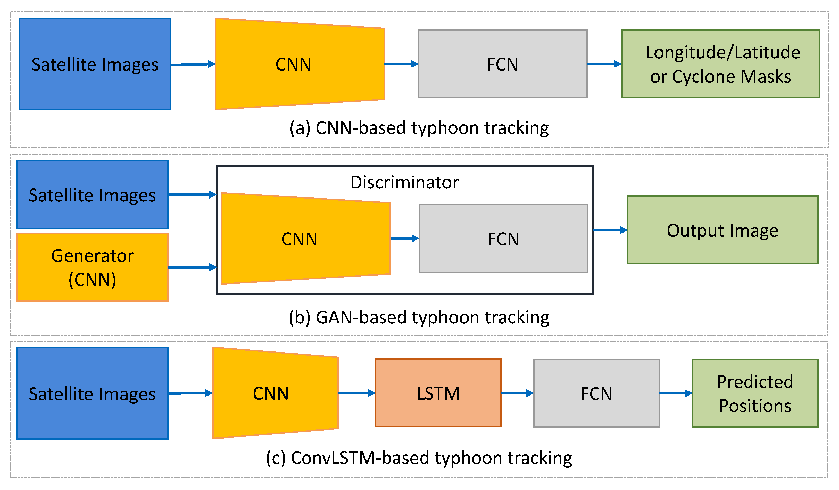
2. CNN-Based Tracking Methods
3. GAN-Based Tracking Methods
4. RNN-Based Tracking Methods
References
- Xing, X.; Yongjie, Y.; Huang, X. Real-time object tracking based on optical flow. In Proceedings of the 2021 International Conference on Computer, Control and Robotics (ICCCR), Shanghai, China, 8–10 January 2021; pp. 315–318.
- Panetta, K.; Kezebou, L.; Oludare, V.; Agaian, S. Comprehensive underwater object tracking benchmark dataset and underwater image enhancement with GAN. IEEE J. Ocean. Eng. 2021, 47, 59–75.
- Yu, H.; Li, G.; Su, L.; Zhong, B.; Yao, H.; Huang, Q. Conditional GAN based individual and global motion fusion for multiple object tracking in UAV videos. Pattern Recognit. Lett. 2020, 131, 219–226.
- Acharya, D.; Ramezani, M.; Khoshelham, K.; Winter, S. BIM-Tracker: A model-based visual tracking approach for indoor localisation using a 3D building model. ISPRS J. Photogramm. Remote Sens. 2019, 150, 157–171.
- Zhao, C.; Liu, H.; Su, N.; Wang, L.; Yan, Y. RANet: A Reliability-Guided Aggregation Network for Hyperspectral and RGB Fusion Tracking. Remote Sens. 2022, 14, 2765.
- Wilson, D.; Alshaabi, T.; Van Oort, C.; Zhang, X.; Nelson, J.; Wshah, S. Object Tracking and Geo-Localization from Street Images. Remote Sens. 2022, 14, 2575.
- Klinger, T.; Rottensteiner, F.; Heipke, C. Probabilistic multi-person localisation and tracking in image sequences. ISPRS J. Photogramm. Remote Sens. 2017, 127, 73–88.
- Zhang, X.; Xia, G.S.; Lu, Q.; Shen, W.; Zhang, L. Visual object tracking by correlation filters and online learning. ISPRS J. Photogramm. Remote Sens. 2018, 140, 77–89.
- Liu, S.; Liu, D.; Srivastava, G.; Połap, D.; Woźniak, M. Overview and methods of correlation filter algorithms in object tracking. Complex Intell. Syst. 2021, 7, 1895–1917.
- Du, S.; Wang, S. An overview of correlation-filter-based object tracking. IEEE Trans. Comput. Soc. Syst. 2021, 9, 18–31.
- Xu, T.; Feng, Z.; Wu, X.J.; Kittler, J. Adaptive channel selection for robust visual object tracking with discriminative correlation filters. Int. J. Comput. Vis. 2021, 129, 1359–1375.
- Lyu, Y.; Yang, M.Y.; Vosselman, G.; Xia, G.S. Video object detection with a convolutional regression tracker. ISPRS J. Photogramm. Remote Sens. 2021, 176, 139–150.
- Hong, S.; Kim, S.; Joh, M.; Song, S.k. Globenet: Convolutional neural networks for typhoon eye tracking from remote sensing imagery. arXiv 2017, arXiv:1708.03417.
- Lu, C.; Kong, Y.; Guan, Z. A mask R-CNN model for reidentifying extratropical cyclones based on quasi-supervised thought. Sci. Rep. 2020, 10, 15011.
- Rüttgers, M.; Lee, S.; Jeon, S.; You, D. Prediction of a typhoon track using a generative adversarial network and satellite images. Sci. Rep. 2019, 9, 6057.
- Na, B.; Son, S. Prediction of atmospheric motion vectors around typhoons using generative adversarial network. J. Wind. Eng. Ind. Aerodyn. 2021, 214, 104643.
- Rüttgers, M.; Jeon, S.; Lee, S.; You, D. Prediction of Typhoon Track and Intensity Using a Generative Adversarial Network With Observational and Meteorological Data. IEEE Access 2022, 10, 48434–48446.
- Hong, S.; Kim, S.; Joh, M.; Song, S.K. PSIque: Next, sequence prediction of satellite images using a convolutional sequence-to-sequence network. arXiv 2017, arXiv:1711.10644.
- Zhang, Y.; Chandra, R.; Gao, J. Cyclone track prediction with matrix neural networks. In Proceedings of the 2018 International Joint Conference on Neural Networks (IJCNN), Rio de Janeiro, Brazil, 8–13 July 2018; pp. 1–8.
- Kim, S.; Kang, J.S.; Lee, M.; Song, S.K. DeepTC: ConvLSTM network for trajectory prediction of tropical cyclone using spatiotemporal atmospheric simulation data. In Proceedings of the NIPS 2018 Workshop Spatiotemporal Workshop, 32nd Annual Conference on Neural Information Processing Systems, Montréal, Canada, 3–8 December 2018.
- Smith, M.; Toumi, R. Using video recognition to identify tropical cyclone positions. Geophys. Res. Lett. 2021, 48, e2020GL091912.
- Qin, W.; Tang, J.; Lu, C.; Lao, S. A typhoon trajectory prediction model based on multimodal and multitask learning. Appl. Soft Comput. 2022, 122, 108804.
- Na, Y.; Na, B.; Son, S. Near real-time predictions of tropical cyclone trajectory and intensity in the northwestern Pacific Ocean using echo state network. Clim. Dyn. 2022, 58, 651–667.
- Ou, M.L.; Jae-Gwang-Won, S.R.C. Introduction to the COMS Program and its application to meteorological services of Korea. In Proceedings of the 2005 EUMETSAT Meteorological Satellite Conference, Dubrovnik, Croatia, 19–23 September 2005; pp. 19–23.

