Your browser does not fully support modern features. Please upgrade for a smoother experience.
Submitted Successfully!
 +1 credit
Thank you for your contribution! You can also upload a video entry or images related to this topic.
For video creation, please contact our Academic Video Service.
| Version | Summary | Created by | Modification | Content Size | Created at | Operation |
|---|---|---|---|---|---|---|
| 1 | Eliseo Roma | -- | 2690 | 2022-05-25 10:17:31 | | | |
| 2 | Lindsay Dong | + 3 word(s) | 2693 | 2022-05-26 04:20:09 | | |
Video Upload Options
We provide professional Academic Video Service to translate complex research into visually appealing presentations. Would you like to try it?
Cite
If you have any further questions, please contact Encyclopedia Editorial Office.
Roma, E.; Catania, P. Precision Oliviculture. Encyclopedia. Available online: https://encyclopedia.pub/entry/23338 (accessed on 24 June 2026).
Roma E, Catania P. Precision Oliviculture. Encyclopedia. Available at: https://encyclopedia.pub/entry/23338. Accessed June 24, 2026.
Roma, Eliseo, Pietro Catania. "Precision Oliviculture" Encyclopedia, https://encyclopedia.pub/entry/23338 (accessed June 24, 2026).
Roma, E., & Catania, P. (2022, May 25). Precision Oliviculture. In Encyclopedia. https://encyclopedia.pub/entry/23338
Roma, Eliseo and Pietro Catania. "Precision Oliviculture." Encyclopedia. Web. 25 May, 2022.
Copy Citation
Precision oliviculture (PO) is having an increasing scientific interest and impact on the sector. Its implementation depends on various technological developments: sensors for local and remote crop monitoring, global navigation satellite system (GNSS), equipment and machinery to perform site-specific management through variable rate application (VRA), implementation of geographic information systems (GIS), and systems for analysis, interpretation, and decision support (DSS).
precision oliviculture
olive tree management
precision farming
remote sensing
proximal sensing
precision irrigation
precision fertilization
1. Introduction
Precision agriculture represents one of the most important opportunities that can be implemented by companies in order to ensure quantitatively and qualitatively satisfactory productions [1][2]. Recently, the International Society of Precision Agriculture (ISPA) released this definition:
“Precision Agriculture is a management strategy that gathers, processes and analyses temporal, spatial and individual data and combines it with other information to support management decisions according to estimated variability for improved resource use efficiency, productivity, quality, profitability and sustainability of agricultural production.”
Precision farming (PF) is a management method that aims to investigate the spatial and temporal variability of an agroecosystem in order to carry out site-specific treatments, applying different technologies and methodologies. The intra- and inter-crop variability that occurs within the crop is determined by the spatial and temporal variability of the soil, the crop species, and the climate [3]. The main advantages of this practice include: savings on the quantity of inputs used [4][5], lower environmental impact [6], higher crop productivity, and product quality. Its application is widely carried out in herbaceous crops and, to a lesser extent, in tree crops, where PF is mainly applied in viticulture, as it succeeds in achieving the best combination of production quality, environmental impact, and costs [7].
In recent years, there has been an increase in the agricultural area devoted to olive growing and in the consumption of extra virgin olive oil (EVOO) [8]. In addition, a continuous change in cultivation techniques has been observed, which poses new challenges to ensure the environmental and economic sustainability of olive farms [9]. Today, the olive tree is cultivated in about 40 countries and occupies a global area of about 10.5 million hectares [8]. Its cultivation is almost entirely (over 98%) in countries bordering the Mediterranean Sea, where olive growing has always been a traditional practice and a descriptive element of many landscapes in rural and peri-urban areas [10]. However, it is also continuously expanding in other continents, such as Australia and South America [8]. The world olive system is divided into three forms of cultivation: traditional olive cultivation (OT), intensive (HI) or high intensity (HD) olive cultivation, and superintensive (SHI) or very high density (SHD) olive cultivation [11][12]. These three major classes are profoundly different in cultivation techniques and require appropriate agronomic choices for a successful crop.
These techniques are able to modify the vegetative and productive activity of the olive tree and require appropriate choices depending on the agro-climatic context. These include phytosanitary management, irrigation, soil management, pruning, fertilization, etc. However, the most important agronomic practices that need to be different depending on the type of cropping system in which precision farming can allow a clear improvement are fertilization and irrigation.
2. Remote Sensing Sensors for Spatial Variability Detection
The first step in precision agriculture is the investigation of spatial variability, using different types of sensors capable of acquiring raster or vector information [13]. As reported by Zhang et al. (2002) [13], the variability affecting agricultural production can be classified into six groups: yield variability; field variability; soil variability; crop variability; variability related to abnormal factors; and management variability. The sensors used for this purpose are capable of acquiring information of different kinds and cover a more or less wide area. In order to be able to apply them in the best possible way, it is necessary to know the variable to be investigated and the acquisition platform on which they will be placed. In fact, the same sensor, such as a multispectral camera, can be used on remote or proximal sensing platforms and give very different information.
2.1. Sensors and Technologies for Identifying the Physiological State of the Olive Tree
For the identification of nutritional deficiencies, canopy structural information, water status of olive trees, and more generally plant health conditions, sensors capable of detecting the electromagnetic energy reflected or emitted by plants are used in precision agriculture [14]. This is because leaf reflectance is influenced by several factors (presence or absence of particular molecules, environmental factors, etc.) in specific regions of the electromagnetic spectrum, such as: in the visible wavelengths by photosynthetic pigments such as chlorophyll a, chlorophyll b, and carotenoids; in the near-infrared by leaf structure (size and distribution of air and water inside the canopy), and the presence of water and biochemical substances such as lignin, cellulose, starch, proteins, and nitrogen [15]. Therefore, this optical technique is based on measuring the reflectance of incident electromagnetic radiation at different wavelengths in the range from 350 to approximately 25,000 nm. This range includes the frequency bands most commonly used in precision farming, such as: visible (VIS), near-infrared (NIR), shortwave infrared (SWIR), and thermal infrared (TIR). The set of spectral responses of a crop at high spectral resolution (narrow bands) allows its spectral signature to be identified. The spectral signature is typical for each crop and each stress situation (Figure 1).
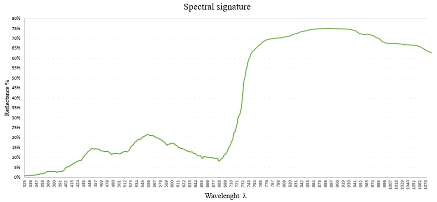
Figure 1. Spectral signature of the olive tree.
Since the 1980s, the first vegetation indices (VI) have been created to examine growing conditions. These are calculated from the individual reflectance value wavelengths acquired. These are classified into two large families: slope-based and distance-based [16]. In addition to their simple use, several processing techniques have also been experimented with in order to obtain greater precision and information of vegetation indices such as smooting (SM), partial least squares regression (PLSR) techniques, etc. Using PLSR techniques, it is possible to extrapolate spectral information of the crop from the entire reflectance spectrum (350–2500 nm) [17]. In olive trees, the most widely used VI are probably the normalized difference vegetation index (NDVI) and the soil-adjusted vegetation index (SAVI). However, there have not yet been exhaustive studies in the field that have determined their real potential for use in stress discrimination. Given the high sensitivity of Vis to variations in chlorophyll content, nitrogen, and plant nutritional status, their application has focused on precision fertilization techniques [18][19][20] and precision irrigation [21].
Precision irrigation is currently more and more successful, also due to the high technology push and the gradual reduction of the cost of the necessary equipment in the last years [22]. However, it still remains a well implemented practice for different crops [23]. In precision oliviculture, this practice is under continuous experimentation, since the spatially variable application of water is advantageous for environmental, economic, and management sustainability (cost reduction, better balance between production and vegetation, and higher quality of the final product). Several techniques can be used to directly or indirectly determine the water status of the crop. The most widely used in precision oliviculture to investigate the entire variability of the field are thermography and/or the use of Vis closely linked to the crop’s water content.
The main advantage of using Vis for the identification of plant water conditions lies in the possibility of exploiting the wavelengths that are recorded with multispectral or better hyperspectral chambers, which are usually used for the identification of the correct nutritional and health status of crops. These Vis are based on reflectance spectroscopy in the electromagnetic regions of the visible (VIS), near infrared (NIR), and shortwave infrared (SWIR) and can be applied for indirect assessments of the water status of olive trees, as water content can greatly influence crop spectral signatures [24][25][26][27].
2.2. Sensors and Technologies for Olive Canopy Characterization
Characterization of the canopy provides us with data on the amount of biomass, growth activity, productivity, water consumption [28], health status, etc. Thus, canopy characteristics provide valuable information for specific tree management to reduce production costs and environmental pollution. There is a whole range of key cultivation operations, such as pesticide treatments [29], irrigation [30][31], and fertilization that depend largely on the structural and geometric properties of the trees. When talking about geometric variables, it refers to tree height, volume, area, and width, while structural variables mainly concern leaf area index (LAI), canopy penetrability, and canopy porosity. These can be determined in different ways and in a more or less empirical manner. Of these, the leaf area index (LAI) is the most important parameter. The LAI is a dimensionless variable and was initially defined as the total unilateral area of photosynthetic tissue per unit area of soil [32][33].
The structural and geometrical parameters of trees, such as volume and vegetation area, are generally derived from manual measurements of height and width. However, as this methodology is slow and expensive, alternative methods have been used in the last 10 years. The measurement and structural characterization of plants can be carried out remotely using different sensing principles. The main technologies that can be used for geometric characterization of crops include: ultrasound-based systems [34], digital photographs [35], laser sensors [36][37], stereoscopic images [38], light sensors [39][40], high-resolution radar images [41], or high-resolution X-ray computed tomography [42]. Among these, light detection and ranging (LiDAR) and stereoscopic vision systems are probably the most promising techniques to obtain 3D images and maps of plants and canopies [43]. It must be stressed that not all the previously mentioned technologies have been able to best describe the 3D structure of trees, due to the actual field conditions.
For the manual characterization of the olive tree canopy, several methods can be used. The main methods are the projected vertical crown area (VCPA) method, ellipsoid volume (VE) method, and tree silhouette volume (VTS) method [44]. The main disadvantage of these methods concerns their high laboriousness without any possibility of being able to investigate the whole spatial variability of the plot. The methods of detecting biophysical parameters of olive trees remotely can be estimated from satellite area platforms with high spatial resolution [45], on UAV [28][46][47], from sensors mounted on unmanned aerial vehicle (UGV) or on tractors [44][47][48].
A technology that arouses interest especially for canopy qualification in order to better define the direction and quantity of plant protection product is the use of ultrasound [48]. Ultrasonic sensors turn out to be cheap, robust, simple to use, and have shown reasonable accuracy under field conditions, sufficient for most cases [43][49]. On the other hand, their main disadvantage is the error produced by some factors, mainly the shape and distance from the target, interference with the signal coming from the sensors, atmospheric conditions, and a low spatial resolution (requiring the use of a larger number of sensors).
3. Monitoring Technologies That Can Be Used in Precision Olive Growing
3.1. Remote Sensing
The technologies available for the remote investigation of olive trees are very varied and allow increasingly precise monitoring. These are remote image acquisitions with different resolution scales, capable of describing the olive grove by detecting and recording reflected sunlight or wavelengths emitted from the surface of objects. Remote sensing techniques quickly provide a description of the shape, size, vigor, water status, nutritional status, stress state of the olive tree, and allow the assessment of variability within the olive grove. The three platforms mainly used in remote sensing are satellites, aircraft, and unmanned aerial vehicles or remotely-piloted aerial systems (UAV or RPAS). There are substantial differences between the different acquisition platforms depending on the acquisition distance and the technical characteristics of the platforms themselves. In the case of precision oliviculture, it is possible to adopt satellite or airborne remote sensing techniques and obtain acceptable results [5][50]. Such techniques can be used mainly at territorial level, for olive groves of large extents and with very large planting distances or even by public administrations and control bodies [51]. However, as today’s olive cultivation is also characterized by promiscuous forms of cultivation, with very small areas, this type of acquisition does not lend itself very well to precise monitoring in all forms of cultivation and to the correct application of variable rate technologies. On the other hand, when UAV platforms are adopted, plant investigation can be carried out with greater accuracy and precision of data (Figure 2), and even spatial resolutions of the order of a few centimeters can be achieved [52][53]. However, there are studies that emphasize the potential of remote sensing from satellite for the acquisition of multispectral images, especially when dealing with large areas [54][55][56].
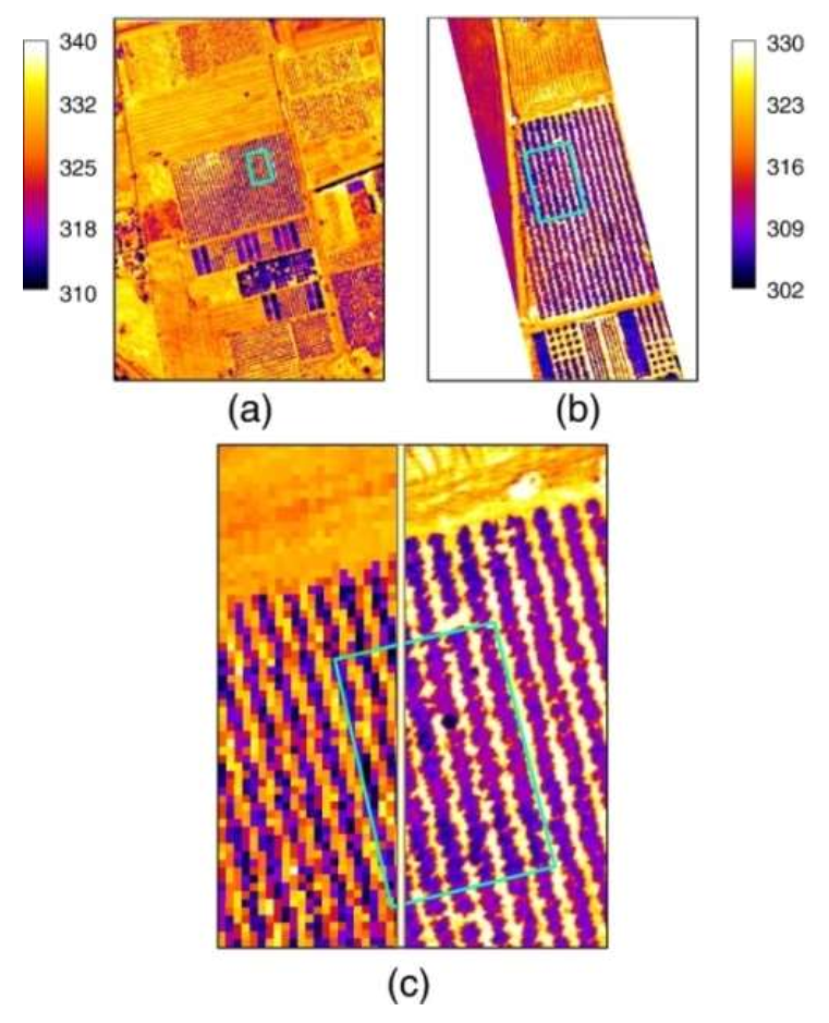
Figure 2. Airborne thermal imagery acquired over the study site: (a) AHS image collected at 12:30GMT on 16 July 2005; (b) UAV image collected at 13:30 GMT on 23 August 2007; (c) image detail showing the spatial resolution differences of AHS (2 m) against the UAV (40 cm). The spatial resolution of the UAV imagery shows individual tree crown, enabling pure crown temperature extraction. Data from [53].
All of the above platforms can be used to obtain information on soil, climate, and, above all, crops. Naturally, crop information is of greater interest as it allows the direct investigation of the health status of the olive tree [57], in order to make the correct site-specific applications. The method involves the acquisition of different types of images such as multispectral, hyperspectral, and thermal images. From their processing, using GIS and photogrammetry software, it is possible to obtain the different information. Generally, there is also the need to carry out direct measurements in the field in order to better calibrate the final information by making it quantitative. In this way, it is possible to obtain thematic maps that are used to construct the prescription maps that represent the basis for carrying out site-specific management [4][55][58].
3.2. Proximal Sensing
Proximal sensing is a data acquisition system that exploits different technologies that are in proximity to or directly in contact with the target surface (land surface or plant). The main feature of proximal sensing is the high accuracy of the data compared to remote sensing but generally lower than in the laboratory. Another important feature of this system is that the sensors can be used either on-line or off-line. In-line sensors are generally used to directly perform operations in the field while off-line sensors need to be processed in order to be used [59]. The advantages of proximal sensors advantages are their high-resolution imagery; their independence from external parameters; their suitability for small fields; and their simple application (i.e., mounting the sensor on the tractor). A very important factor to consider is the different sources of information that can be generated compared to remote sensing due to the different sensor-object position. The limitations of proximal sensing are due to its high cost and its low capacity to acquire data that are able to describe the entire variability present in the plot. In fact, they are often point data, which have to be spatialized in order to refer to the whole area [13]. The ground platforms used for proximal sensing can be grouped into three categories: portable, self-supporting in the field, and mounted on tractors or agricultural machinery or UGVs [60]. Regarding the use of UGVs in precision oliviculture, there have been no scientific applications in the literature yet, although the progress made in other sectors bodes well for their future application in olive cultivation [61].
Among the most interesting applications of proximal sensing with a direct effect on precision olive growing are LiDAR [44][48] and ultrasonic sensors [47]. The latter have found practical use on the distribution of plant protection products. [62] created an ultrasonic prototype that allowed the automatic calibration of plant protection products, based on the architecture of the canopy.
Among the proximal sensors are those involved in monitoring olive yield. [63] initiated precision farming applied to olive groves, through the simple application of GPS sensors to map the production of olive trees. In fact, the production map represents one of the main sources of information for the creation of the correct fertilization map [64][65]. Ref. [66] was able to determine area production (20–30 trees per area) simply by weighing production. In other fields, such as precision viticulture, several on-the-go methods already exist that can map plant production. The idea would be to be able to transfer this type of technology to precision olive growing as well, in order to obtain data on the productivity of individual trees, as this is one of the most important pieces of basic information. There are also other portable instruments that allow, for example, the calculation of chlorophyll content or the spectral response of the olive tree, directly in the field. However, they have not been well investigated for use in precision oliviculture.
References
- Fountas, S.; Aggelopoulou, K.; Gemtos, T.A. Precision Agriculture: Crop Management for Improved Productivity and Reduced Environmental Impact or Improved Sustainability. In Supply Chain Management for Sustainable Food Networks; John Wiley & Sons: Hoboken, NJ, USA, 2015; pp. 41–65.
- Schrijver, R.; Poppe, K.; Daheim, C. Precision Agriculture and the Future of Farming in Europe; Science and Technology Options Assessment: Brussels, Belgium, 2016; Available online: http://www.ep.europa.eu/stoa (accessed on 26 January 2022).
- Lal, R. 16 Challenges and Opportunities in Precision Agriculture. Soil-Specif. Farming Precis. Agric. 2015, 22, 391.
- López-Granados, F.; Jurado-Expósito, M.; Alamo, S.; Garcıa-Torres, L. Leaf Nutrient Spatial Variability and Site-Specific Fertilization Maps within Olive (Olea Europaea L.) Orchards. Eur. J. Agron. 2004, 21, 209–222.
- Noori, O.; Panda, S.S. Site-Specific Management of Common Olive: Remote Sensing, Geospatial, and Advanced Image Processing Applications. Comput. Electron. Agric. 2016, 127, 680–689.
- Van Evert, F.K.; Gaitán-Cremaschi, D.; Fountas, S.; Kempenaar, C. Can Precision Agriculture Increase the Profitability and Sustainability of the Production of Potatoes and Olives? Sustainability 2017, 9, 1863.
- Santesteban, L.G. Precision Viticulture and Advanced Analytics. A Short Review. Food Chem. 2019, 279, 58–62.
- FAOSTAT. Statistics; Food and Agriculture Organization of the United Nations: Rome, Italy, 2020.
- De Gennaro, B.; Notarnicola, B.; Roselli, L.; Tassielli, G. Innovative Olive-Growing Models: An Environmental and Economic Assessment. J. Clean. Prod. 2012, 28, 70–80.
- Baldoni, L.; Belaj, A. Olive. In Oil Crops; Springer: Cham, Switzerland, 2009; pp. 397–421.
- Rallo, L. The Olive Industry in Spain. In Proceedings of the Olivebioteq 2006, 2nd Int Sem, Recent Advances in Olive Industry, Special Seminars and Invited Lectures, Marsala, Mazara del Vallo, Italy, 5–10 November 2006; pp. 151–162.
- Tous, J.; Romero, A.; Hermoso, J. The Hedgerow System for Olive Growing. Olea FAO Olive Netw. 2007, 26, 20–26.
- Zhang, N.; Wang, M.; Wang, N. Precision Agriculture—A Worldwide Overview. Comput. Electron. Agric. 2002, 36, 113–132.
- Rubio-Delgado, J.; Pérez, C.J.; Vega-Rodríguez, M.A. Predicting Leaf Nitrogen Content in Olive Trees Using Hyperspectral Data for Precision Agriculture. Precis. Agric. 2021, 22, 1–21.
- Liang, S. Quantitative Remote Sensing of Land Surfaces; John Wiley & Sons: Hoboken, NJ, USA, 2005; Volume 30, ISBN 0-471-72371-1.
- Xue, J.; Su, B. Significant Remote Sensing Vegetation Indices: A Review of Developments and Applications. J. Sens. 2017, 2017, 1353691.
- Hansen, P.; Schjoerring, J. Reflectance Measurement of Canopy Biomass and Nitrogen Status in Wheat Crops Using Normalized Difference Vegetation Indices and Partial Least Squares Regression. Remote Sens. Environ. 2003, 86, 542–553.
- Ali, M.; Al-Ani, A.; Eamus, D.; Tan, D.K. Leaf Nitrogen Determination Using Non-Destructive Techniques–A Review. J. Plant Nutr. 2017, 40, 928–953.
- Barranco Navero, D.; Fernandez Escobar, R.; Rallo Romero, L. El Cultivo del Olivo, 7th ed.; Mundi-Prensa Libros: Madrid, Spain, 2017; ISBN 84-8476-714-0.
- Rotundo, A.; Lombardo, N.; Marone, E.; Fiorino, P. La Nutrizione Minerale e Le Concimazioni. 2003. Available online: https://www.scirp.org/%28S%28lz5mqp453edsnp55rrgjct55%29%29/reference/referencespapers.aspx?referenceid=2134774 (accessed on 26 January 2022).
- Fernández, J.E.; Diaz-Espejo, A.; Romero, R.; Hernandez-Santana, V.; García, J.M.; Padilla-Díaz, C.M.; Cuevas, M.V. Precision Irrigation in Olive (Olea Europaea L.) Tree Orchards. In Water Scarcity and Sustainable Agriculture in Semiarid Environment; Elsevier: Amsterdam, The Netherlands, 2018; pp. 179–217.
- Noguera, M.; Millán, B.; Pérez-Paredes, J.J.; Ponce, J.M.; Aquino, A.; Andújar, J.M. A New Low-Cost Device Based on Thermal Infrared Sensors for Olive Tree Canopy Temperature Measurement and Water Status Monitoring. Remote Sens. 2020, 12, 723.
- Cohen, Y.; Alchanatis, V.; Meron, M.; Saranga, Y.; Tsipris, J. Estimation of Leaf Water Potential by Thermal Imagery and Spatial Analysis. J. Exp. Bot. 2005, 56, 1843–1852.
- Jorge, J.; Vallbé, M.; Soler, J.A. Detection of Irrigation Inhomogeneities in an Olive Grove Using the NDRE Vegetation Index Obtained from UAV Images. Eur. J. Remote Sens. 2019, 52, 169–177.
- Agam, N.; Segal, E.; Peeters, A.; Levi, A.; Dag, A.; Yermiyahu, U.; Ben-Gal, A. Spatial Distribution of Water Status in Irrigated Olive Orchards by Thermal Imaging. Precis. Agric. 2014, 15, 346–359.
- Elsayed, S.; Mistele, B.; Schmidhalter, U. Can Changes in Leaf Water Potential Be Assessed Spectrally? Funct. Plant Biol. 2011, 38, 523–533.
- Sims, D.A.; Gamon, J.A. Relationships between Leaf Pigment Content and Spectral Reflectance across a Wide Range of Species, Leaf Structures and Developmental Stages. Remote Sens. Environ. 2002, 81, 337–354.
- Caruso, G.; Zarco-Tejada, P.J.; González-Dugo, V.; Moriondo, M.; Tozzini, L.; Palai, G.; Rallo, G.; Hornero, A.; Primicerio, J.; Gucci, R. High-Resolution Imagery Acquired from an Unmanned Platform to Estimate Biophysical and Geometrical Parameters of Olive Trees under Different Irrigation Regimes. PLoS ONE 2019, 14, e0210804.
- Gil, E.; Arnó, J.; Llorens, J.; Sanz, R.; Llop, J.; Rosell-Polo, J.R.; Gallart, M. Advanced Technologies for the Improvement of Spray Application Techniques in Spanish Viticulture: An Overview. Sensors 2014, 14, 691–708.
- Rufat, J.; Romero-Aroca, A.J.; Arbonés, A.; Villar, J.M.; Hermoso, J.F.; Pascual, M. Mechanical Harvesting and Irrigation Strategy Responses on ‘Arbequina’Olive Oil Quality. HortTechnology 2018, 28, 607–614.
- Sola-Guirado, R.R.; Castillo-Ruiz, F.J.; Jiménez-Jiménez, F.; Blanco-Roldan, G.L.; Castro-Garcia, S.; Gil-Ribes, J.A. Olive Actual “on Year” Yield Forecast Tool Based on the Tree Canopy Geometry Using UAS Imagery. Sensors 2017, 17, 1743.
- Jonckheere, I.; Fleck, S.; Nackaerts, K.; Muys, B.; Coppin, P.; Weiss, M.; Baret, F. Review of Methods for in Situ Leaf Area Index Determination: Part I. Theories, Sensors and Hemispherical Photography. Agric. For. Meteorol. 2004, 121, 19–35.
- Villalobos, F.; Testi, L.; Hidalgo, J.; Pastor, M.; Orgaz, F. Modelling Potential Growth and Yield of Olive (Olea Europaea L.) Canopies. Eur. J. Agron. 2006, 24, 296–303.
- Zaman, Q.; Schumann, A.W. Performance of an Ultrasonic Tree Volume Measurement System in Commercial Citrus Groves. Precis. Agric. 2005, 6, 467–480.
- Hernández-Clemente, R.; Navarro-Cerrillo, R.M.; Ramírez, F.J.R.; Hornero, A.; Zarco-Tejada, P.J. A Novel Methodology to Estimate Single-Tree Biophysical Parameters from 3D Digital Imagery Compared to Aerial Laser Scanner Data. Remote Sens. 2014, 6, 11627–11648.
- Rosell, J.R.; Llorens, J.; Sanz, R.; Arno, J.; Ribes-Dasi, M.; Masip, J.; Escolà, A.; Camp, F.; Solanelles, F.; Gràcia, F. Obtaining the Three-Dimensional Structure of Tree Orchards from Remote 2D Terrestrial LIDAR Scanning. Agric. For. Meteorol. 2009, 149, 1505–1515.
- Sola-Guirado, R.R.; Bayano-Tejero, S.; Rodríguez-Lizana, A.; Gil-Ribes, J.A.; Miranda-Fuentes, A. Assessment of the Accuracy of a Multi-Beam LED Scanner Sensor for Measuring Olive Canopies. Sensors 2018, 18, 4406.
- Rovira-Más, F.; Zhang, Q.; Reid, J. Creation of Three-Dimensional Crop Maps Based on Aerial Stereoimages. Biosyst. Eng. 2005, 90, 251–259.
- Castillo-Ruiz, F.J.; Castro-Garcia, S.; Blanco-Roldan, G.L.; Sola-Guirado, R.R.; Gil-Ribes, J.A. Olive Crown Porosity Measurement Based on Radiation Transmittance: An Assessment of Pruning Effect. Sensors 2016, 16, 723.
- Giuliani, R.; Magnanini, E.; Fragassa, C.; Nerozzi, F. Ground Monitoring the Light–Shadow Windows of a Tree Canopy to Yield Canopy Light Interception and Morphological Traits. Plant Cell Environ. 2000, 23, 783–796.
- Bongers, F. Methods to Assess Tropical Rain Forest Canopy Structure: An Overview. Trop. For. Canopies Ecol. Manag. 2001, 69, 263–277.
- Stuppy, W.H.; Maisano, J.A.; Colbert, M.W.; Rudall, P.J.; Rowe, T.B. Three-Dimensional Analysis of Plant Structure Using High-Resolution X-ray Computed Tomography. Trends Plant Sci. 2003, 8, 2–6.
- Rosell, J.; Sanz, R. A Review of Methods and Applications of the Geometric Characterization of Tree Crops in Agricultural Activities. Comput. Electron. Agric. 2012, 81, 124–141.
- Miranda-Fuentes, A.; Llorens, J.; Gamarra-Diezma, J.L.; Gil-Ribes, J.A.; Gil, E. Towards an Optimized Method of Olive Tree Crown Volume Measurement. Sensors 2015, 15, 3671–3687.
- Gómez, J.; Zarco-Tejada, P.; García-Morillo, J.; Gama, J.; Soriano, M. Determining Biophysical Parameters for Olive Trees Using CASI-Airborne and Quickbird-Satellite Imagery. Agron. J. 2011, 103, 644–654.
- Torres-Sánchez, J.; López-Granados, F.; Serrano, N.; Arquero, O.; Peña, J.M. High-Throughput 3-D Monitoring of Agricultural-Tree Plantations with Unmanned Aerial Vehicle (UAV) Technology. PLoS ONE 2015, 10, e0130479.
- Zarco-Tejada, P.J.; Diaz-Varela, R.; Angileri, V.; Loudjani, P. Tree Height Quantification Using Very High Resolution Imagery Acquired from an Unmanned Aerial Vehicle (UAV) and Automatic 3D Photo-Reconstruction Methods. Eur. J. Agron. 2014, 55, 89–99.
- Gamarra-Diezma, J.L.; Miranda-Fuentes, A.; Llorens, J.; Cuenca, A.; Blanco-Roldán, G.L.; Rodríguez-Lizana, A. Testing Accuracy of Long-Range Ultrasonic Sensors for Olive Tree Canopy Measurements. Sensors 2015, 15, 2902–2919.
- Martínez-Casasnovas, J.A.; Rufat, J.; Arnó, J.; Arbonés, A.; Sebé, F.; Pascual, M.; Gregorio, E.; Rosell-Polo, J.R. Mobile Terrestrial Laser Scanner Applications in Precision Fruticulture/Horticulture and Tools to Extract Information from Canopy Point Clouds. Precis. Agric. 2017, 18, 111–132.
- Cruz-Ramírez, M.; Hervás-Martínez, C.; Jurado-Expósito, M.; López-Granados, F. A Multi-Objective Neural Network Based Method for Cover Crop Identification from Remote Sensed Data. Expert Syst. Appl. 2012, 39, 10038–10048.
- Ferwerda, J.G.; Skidmore, A.K. Can Nutrient Status of Four Woody Plant Species Be Predicted Using Field Spectrometry? ISPRS J. Photogramm. Remote Sens. 2007, 62, 406–414.
- Jurado, J.M.; Ortega, L.; Cubillas, J.J.; Feito, F. Multispectral Mapping on 3D Models and Multi-Temporal Monitoring for Individual Characterization of Olive Trees. Remote Sens. 2020, 12, 1106.
- Berni, J.; Zarco-Tejada, P.; Sepulcre-Cantó, G.; Fereres, E.; Villalobos, F. Mapping Canopy Conductance and CWSI in Olive Orchards Using High Resolution Thermal Remote Sensing Imagery. Remote Sens. Environ. 2009, 113, 2380–2388.
- Peña-Barragán, J.; Jurado-Expósito, M.; López-Granados, F.; Atenciano, S.; Sánchez-De la Orden, M.; Garcıa-Ferrer, A.; Garcıa-Torres, L. Assessing Land-Use in Olive Groves from Aerial Photographs. Agric. Ecosyst. Environ. 2004, 103, 117–122.
- Solano, F.; Di Fazio, S.; Modica, G. A Methodology Based on GEOBIA and WorldView-3 Imagery to Derive Vegetation Indices at Tree Crown Detail in Olive Orchards. Int. J. Appl. Earth Obs. Geoinf. 2019, 83, 101912.
- Zipori, I.; Erel, R.; Yermiyahu, U.; Ben-Gal, A.; Dag, A. Sustainable Management of Olive Orchard Nutrition: A Review. Agriculture 2020, 10, 11.
- Zhang, C.; Kovacs, J.M. The Application of Small Unmanned Aerial Systems for Precision Agriculture: A Review. Precis. Agric. 2012, 13, 693–712.
- Matese, A.; Di Gennaro, S.F. Technology in Precision Viticulture: A State of the Art Review. Int. J. Wine Res. 2015, 7, 69–81.
- Pallottino, F.; Antonucci, F.; Costa, C.; Bisaglia, C.; Figorilli, S.; Menesatti, P. Optoelectronic Proximal Sensing Vehicle-Mounted Technologies in Precision Agriculture: A Review. Comput. Electron. Agric. 2019, 162, 859–873.
- Sishodia, R.P.; Ray, R.L.; Singh, S.K. Applications of Remote Sensing in Precision Agriculture: A Review. Remote Sens. 2020, 12, 3136.
- Saiz-Rubio, V.; Rovira-Más, F.; Cuenca-Cuenca, A.; Alves, F. Robotics-Based Vineyard Water Potential Monitoring at High Resolution. Comput. Electron. Agric. 2021, 187, 106311.
- Solanelles, F.; Planas, S. An Electronic Control System for Proportional Pesticide Application to the Canopy Volume in Tree Crops. In Proceedings of the 2005 EFITA/WCCA Joint Congress on IT in Agriculture, Vila Real, Portugal, 25–28 July 2005; pp. 25–28.
- Alcalá Jiménez, A.; Álamo Romero, S. Using GPS for Yield Mapping in Olive Orchards. In Proceedings of the First International Conference on Geospatial Information in Agriculture and Forestry, Lake Buena Vista, FL, USA, 1–3 June 1998.
- Agüera-Vega, J.; Blanco, G.; Castillo, F.; Castro-Garcia, S.; Gil-Ribes, J.; Perez-Ruiz, M. Determination of Field Capacity and Yield Mapping in Olive Harvesting Using Remote Data Acquisition. In Precision Agriculture’13; Springer: Cham, Switzerland, 2013; pp. 691–696.
- Castillo-Ruiz, F.J.; Pérez-Ruiz, M.; Blanco-Roldán, G.L.; Gil-Ribes, J.A.; Agüera, J. Development of a Telemetry and Yield-Mapping System of Olive Harvester. Sensors 2015, 15, 4001–4018.
- Álamo, S.; Ramos, M.; Feito, F.; Cañas, A. Precision Techniques for Improving the Management of the Olive Groves of Southern Spain. Span. J. Agric. Res. 2012, 583–595.
More
Information
Subjects:
Remote Sensing
Contributors
MDPI registered users' name will be linked to their SciProfiles pages. To register with us, please refer to https://encyclopedia.pub/register
:
View Times:
1.0K
Revisions:
2 times
(View History)
Update Date:
26 May 2022
Table of Contents


Notice
You are not a member of the advisory board for this topic. If you want to update advisory board member profile, please contact office@encyclopedia.pub.
OK
Confirm
Only members of the Encyclopedia advisory board for this topic are allowed to note entries. Would you like to become an advisory board member of the Encyclopedia?
Yes
No
${ textCharacter }/${ maxCharacter }
Submit
Cancel
Back
Comments
${ item }
|
${ item.createdUser.fullName }
${ item.createdAt }
${ item.vote }
${ item.reply }
Delete
${ reply.createdUser.fullName }
${ reply.createdAt }
${ reply.vote }
Delete
There is no reply to this comment~
${ item.replyTextCharacter }/${ item.replyMaxCharacter }
Submit
Cancel
More
No more~
There is no comment~
${ textCharacter }/${ maxCharacter }
Submit
Cancel
${ selectedItem.replyTextCharacter }/${ selectedItem.replyMaxCharacter }
Submit
Cancel
Confirm
Are you sure to Delete?
Yes
No