Your browser does not fully support modern features. Please upgrade for a smoother experience.
Submitted Successfully!
 +1 credit
Thank you for your contribution! You can also upload a video entry or images related to this topic.
For video creation, please contact our Academic Video Service.
| Version | Summary | Created by | Modification | Content Size | Created at | Operation |
|---|---|---|---|---|---|---|
| 1 | CATHERINE HOPE MORALES BUSTILLO | + 1552 word(s) | 1552 | 2022-02-17 07:29:27 | | | |
| 2 | Rita Xu | Meta information modification | 1552 | 2022-02-28 09:13:03 | | |
Video Upload Options
We provide professional Academic Video Service to translate complex research into visually appealing presentations. Would you like to try it?
Cite
If you have any further questions, please contact Encyclopedia Editorial Office.
Bustillo, C.H. Above-and-Belowground Carbon Stocks. Encyclopedia. Available online: https://encyclopedia.pub/entry/19950 (accessed on 27 June 2026).
Bustillo CH. Above-and-Belowground Carbon Stocks. Encyclopedia. Available at: https://encyclopedia.pub/entry/19950. Accessed June 27, 2026.
Bustillo, Catherine Hope. "Above-and-Belowground Carbon Stocks" Encyclopedia, https://encyclopedia.pub/entry/19950 (accessed June 27, 2026).
Bustillo, C.H. (2022, February 27). Above-and-Belowground Carbon Stocks. In Encyclopedia. https://encyclopedia.pub/entry/19950
Bustillo, Catherine Hope. "Above-and-Belowground Carbon Stocks." Encyclopedia. Web. 27 February, 2022.
Copy Citation
Peatlands areas are where partially decayed organic materials accumulate over time and where litter deposition exceeds anaerobic decomposition. These sites are important reservoirs of biodiversity, carbon, and water.
soil respiration
soil carbon
biomass
Philippine peatlands
1. Introduction
Globally, peatlands only cover three percent of the Earth’s land area yet store 2000 Gigatons of CO2 [1], equivalent to 30% of terrestrial carbon (75% of all carbon in the atmosphere) or twice the carbon stored in the forests [2]. About 8% of the global peatland areas are found in the tropics [3]. Tropical peatlands are important terrestrial carbon pools storing 40 to 90 Gt C [4][5] and account for one-third of the world’s soil C pool [6]. In Southeast Asia, peatlands are primarily found in Sumatra, the Malay Peninsula, Borneo (Kalimantan, Sarawak, and Brunei), and New Guinea [7].
Although tropical peatlands are huge carbon reservoirs, they are threatened by climate change and anthropogenic disturbances [8][9]. Land-use change and water management in the oil palm production in Malaysia intensify peat degradation affecting CO2 fluxes from peatlands [10][11]. Human activities such as dam construction across drainage canals in Indonesia increased the decomposition rate of the peat and CO2 emission [12][13]. Degraded drained peatlands store globally ~80.8 Gt soil C and release ~1.91 Gt CO2-eq yr−1 [14]. Other anthropogenic disturbances such as land cultivation, human settlement, forest harvesting, forest fires, and drainage have negatively impacted peatland ecosystems [15][16][17] and consequently contribute to global warming [18].
Peatland disturbance negatively impacts the ecosystem, altering the surface drainage and reducing site productivity [19]. Soil organic matter vulnerability to decomposition increased with an increasing level of disturbance and a decreasing soil organic content (SOC), indicating positive feedback mechanisms [20]. Land-use change, drainage, and agricultural cultivation alter the peatlands’ hydrological and biogeochemical processes, e.g., by enhancing mineralization of the soil organic matter (SOM) [21], turning peatlands into hotspots of greenhouse gas (GHG) emissions from soils [22][23].
The Philippines have 10,700 hectares of peatland area out of the 29 million hectares of peatland existing in Southeast Asia [7]. However, the identification of more peatland sites in the country is ongoing. Like most Southeast Asian peatland sites, the Philippine peatland forests were also disturbed due to the growing population and increasing demand for forest products and services.
Ironically, in much literature for Asian peatland assessments [5], the Philippine peatlands are seldom included in many synthesis studies. Therefore, it is imperative and urgent to publish recent reports on Philippine peatland assessments so that the unique features and estimates can be incorporated in regional peatland studies and contribute to the growing demand for peatland literature in Southeast Asia. Improved knowledge and understanding of the tropical peatland, including the Philippines, is crucial given the rapid exploitation across the tropics, especially in Southeast Asia, the home of vast peatland sites.
One of the heavily disturbed peatland sites in the Philippines is the Bambanin peatland in Mindoro Oriental, located in the western part of the archipelago. This site is mainly affected by agriculture, forest harvesting, and human settlement. In contrast, one relatively undisturbed peatland in the country is the Caimpugan peat area in Agusan Marsh, northeastern Mindanao. However, expanding land conversion for agriculture and ecotourism has threatened this peatland site.
2. The Undisturbed Site
The undisturbed peatland site is located in New Visayas within the Caimpugan peatland in San Francisco, Agusan del Sur, Philippines (Figure 1). This peatland is part of the Agusan Marsh Wildlife Sanctuary, covering an area of 5630 ha. A tall forest can be observed 1.2 km from the river, and the substrate was confirmed to be peat [24]. This tall peat swamp forest is characterized by stilted rooted species predominantly of Tristanopsis [25]. The forest was open enough to allow a relatively thick growth of Pandanus sp. of up to 3 m high and the climbing fern Stenochlaena palustris. The canopy height was 25–30 m [25]. Peat dome, developed between Hobong and Agusan Rivers, was observed in Caimpugan peatland [24]. The typical peat dome in Caimpugan peatland is a product of terrestrialization, where the forest is mostly intact [26]. This peatland has constantly been subjected to flooding by the river, and the input of water is relatively high in nutrients. Flooding by flowing water in the areas close to the river may have reduced the build-up of peat. A small portion of mineral soils on the western side of the Hibong River have been mostly cleared for rice production. Before site clearing for rice culture, the area was a freshwater swamp forest. Adjacent to the river and rice paddies were isolated patches of swampy areas characterized by Terminalia copelandii [25].
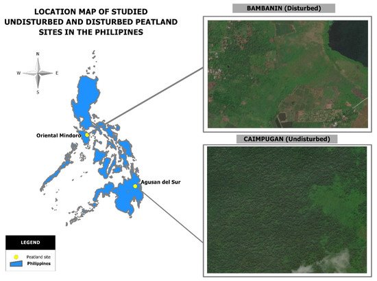
Figure 1. Location map of studied undisturbed and disturbed peatland sites in the Philippines.
Major issues at the Caimpugan peatland site include gradual land conversion for agriculture (ricefields and cash crops); the establishment of oil palm plantations along the periphery of the peatland within the alienable and disposable (A & D) lands; wildlife hunting (deer, birds, wild boar, monkey), and timber poaching [26].
The average temperature in this undisturbed peatland site is 27.84 °C, and the annual rainfall of 4600 mm [24]. Three levels of soil decomposition were reported at this site. These include fibric (early stage of decomposition), hemic (moderate/intermediate decomposition), and sapric (most advanced decomposition). These decomposition levels were based on the US Department of Agriculture [27].
3. The Aboveground Biomass at the Sites
The average aboveground biomass at the undisturbed site was 35.8 ± 30.0 Mg ha−1 (Figure 2). However, the variability was very high at the undisturbed site as the biomass ranged from 0.1 Mg ha−1 to 82.0 Mg ha−1.
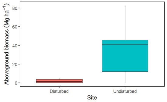
Figure 2. Average aboveground biomass at the disturbed and undisturbed peatland sites. In the boxplots, the thick horizontal line shows the median; the box extends to the upper and lower quartiles, and the thin vertical line outside the box indicates the nominal range.
On the other hand, the average aboveground biomass at the disturbed site was 2.0 ± 1.9 Mg ha−1 (Figure 2), which varied from 0.2 Mg ha−1 to 4.6 Mg ha−1.
4. The Aboveground Biomass per Species
The disparity between the species with the highest biomass and the rest in either undisturbed or disturbed peatland sites was huge. For example, the species with the highest biomass at the undisturbed site was Tristaniopis decorticata (Merr.) Peter, with an aboveground biomass of 80.8 Mg ha−1, yet, the species with the second-highest aboveground biomass had only 39.4 Mg ha−1. Whereas, the remainder of the species had 1.7 to 32.7 Mg ha−1 (Figure 3).
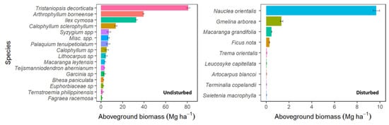
Figure 3. The aboveground biomass of important tree species at the undisturbed (left panel) and disturbed (right panel) peatland sites. The horizontal line indicates ± standard deviation.
Similarly, the highest aboveground biomass at the disturbed site was Nauclea orientalis (L.) L. (9.67 Mg ha−1), while the species with the second-highest aboveground biomass only had 1.34 Mg ha−1, and the rest had below 1.0 Mg ha−1 (Figure 3).
5. The Aboveground Carbon Content
The aboveground C content at the undisturbed site ranged from 1.29 Mg C ha−1 to 37.2 Mg C ha−1 (Figure 4a). The contour plot showed that plots 1 and 6 were within the upper range of the aboveground C stock estimates (21.1 Mg C ha−1–32.7 Mg C ha−1) characterized by tall pole forest. Plots 2 and 5 had an aboveground C stock from 17.8 Mg C ha−1–19.3 Mg C ha−1, classified into an intermediate forest. The aboveground C at plots 3 and 4 were surprisingly low compared with other plots (0.06 Mg C ha−1–1.29 Mg C ha−1). These plots (3 and 4) were characterized by smaller tree structures akin to a pygmy forest and possibly were located in the peat dome. Differences in aboveground C in the study plots indicate the topographic and hydrologic variability within the peatland site.
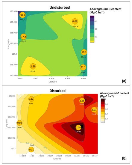
Figure 4. Map of the variations in aboveground C content as a function of site coordinates in (a) undisturbed peatland site in Caimpugan, Agusan del Sur and (b) disturbed peatland site in Bambanin, Mindoro Oriental, all in the Philippines. Yellow circles represent sampling plots in both undisturbed and disturbed plots. Values within each circle are the average aboveground C in each plot.
At the disturbed site, the aboveground C content ranged from 0.1 Mg C ha−1 to 2.1 Mg C ha−1 (Figure 4b), and the variability among plots was relatively low.
6. Soil Carbon Content
The overall average soil C content at the undisturbed site was 750 ± 710 Mg ha−1. As the soil profile gets deeper, the soil C content becomes higher. This trend was evident in their undisturbed site, where an increasing soil C stock was observed from 217 ± 65 Mg ha−1 at a soil depth of 0–15 cm to 2181 ± 908 Mg ha−1 at 50–100 cm depth (p < 0.05; Figure 5).
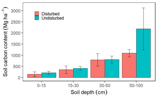
Figure 5. Average soil carbon content per soil depth classes at the disturbed and undisturbed peatland sites. Vertical lines depict ± standard deviation.
At the disturbed site, the overall average soil C content at all depth levels was 595 ± 406 Mg ha−1. At 0–15 cm soil depth, the average soil C content was 149 ± 104 Mg ha−1, increasing the soil C stock up to 1092 ± 165 Mg ha−1 at a soil depth of 50–100 cm (p < 0.05; Figure 5).
7. Soil Carbon Fluxes
At the undisturbed site, the soil carbon emission was 3.6 ± 3.0 g C m−2 d−1. The soil emission rate at the disturbed site was 11.2 ± 6.4 g C m−2d−1 (Figure 6). Suppose researchers set aside all aspects of differences from both sites and consider them comparable; the soil carbon emission from the undisturbed site was only one-third of the emission rate at the disturbed site. However, direct comparisons need to consider the considerable differences in site condition, climate, and vegetation.
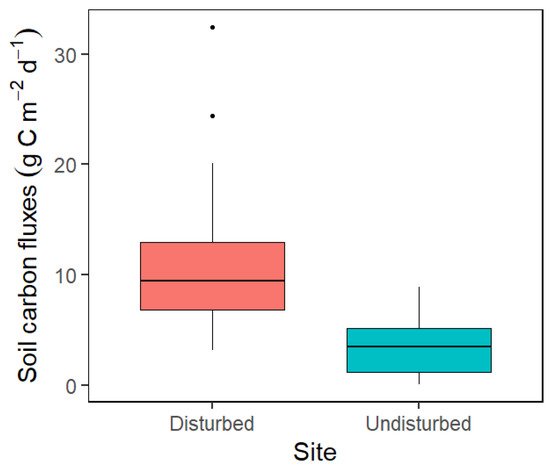
Figure 6. Average soil carbon fluxes at the disturbed and undisturbed peatland sites. In the boxplots, the thick horizontal line shows the median; the box extends to the upper and lower quartiles, and the thin vertical line outside the box indicates the nominal range.
References
- Verwer, C.; Van Der Meer, P.; Nabuurs, G.-J. Review of Carbon Flux Estimates and Other Greenhouse Gas Emissions from Oil Palm Cultivation on Tropical Peatlands-Identifying the Gaps in Knowledge; Wageningen Environmental Research (Alterra): Wageningen, The Netherlands, 2008.
- Parish, F.; Sirin, A.; Charman, D.; Joosten, H.; Minayeva, T.; Silvius, M.; Stringer, L. Assessment on Peatlands, Biodiversity and Climate Change: Main Report; Global Environment Centre, Kuala Lumpur and Wetlands International: Wageningen, The Netherlands, 2008; ISBN SBN978-983-43751-0-2.
- Hergoualc’h, K.; Verchot, L.V. Greenhouse gas emission factors for land use and land-use change in Southeast Asian peatlands. Mitig. Adapt. Strateg. Glob. Chang. 2014, 19, 789–807.
- Yu, Z.; Loisel, J.; Brosseau, D.P.; Beilman, D.W.; Hunt, S.J. Global peatland dynamics since the last glacial maximum. Geophys. Res. Lett. 2010, 37, 37.
- Page, S.E.; Rieley, J.O.; Banks, C.J. Global and regional importance of the tropical peatland carbon pool. Glob. Chang. Biol. 2011, 17, 798–818.
- Turetsky, M.; Wieder, K.; Halsey, L.; Vitt, D. Current disturbance and the diminishing peatland carbon sink. Geophys. Res. Lett. 2002, 29, 21-1–21-4.
- Page, S.E.; Rieley, J.O.; Wust, R. Chapter 7 Lowland tropical peatlands of Southeast Asia. Dev. Earth Surf. Process. 2006, 9, 145–172.
- Hernández-Delgado, E.A. The emerging threats of climate change on tropical coastal ecosystem services, public health, local economies and livelihood sustainability of small islands: Cumulative impacts and synergies. Mar. Pollut. Bull. 2015, 101, 5–28.
- Veloo, R.; Paramananthan, S.; Van Ranst, E. Classification of tropical lowland peats revisited: The case of Sarawak. Catena 2014, 118, 179–185.
- Sangok, F.E.; Maie, N.; Melling, L.; Watanabe, A. Evaluation on the decomposability of tropical forest peat soils after conversion to an oil palm plantation. Sci. Total Environ. 2017, 587–588, 381–388.
- Tonks, A.J.; Aplin, P.; Beriro, D.J.; Cooper, H.; Evers, S.; Vane, C.H.; Sjögersten, S. Impacts of conversion of tropical peat swamp forest to oil palm plantation on peat organic chemistry, physical properties and carbon stocks. Geoderma 2017, 289, 36–45.
- Hooijer, A.; Page, S.; Canadell, J.G.; Silvius, M.; Kwadijk, J.; Wösten, H.; Jauhiainen, J. Current and future CO2 emissions from drained peatlands in Southeast Asia. Biogeosciences 2010, 7, 1505–1514.
- Leng, L.Y.; Ahmed, O.H.; Jalloh, M.B. Brief review on climate change and tropical peatlands. Geosci. Front. 2019, 10, 373–380.
- Leifeld, J.; Menichetti, L. The underappreciated potential of peatlands in global climate change mitigation strategies. Nat. Commun. 2018, 9, 1071.
- Dohong, A.; Aziz, A.A.; Dargusch, P. A review of the drivers of tropical peatland degradation in South-East Asia. Land Use Policy 2017, 69, 349–360.
- Murdiyarso, D.; Hergoualc’h, K.; Verchot, L. V Opportunities for reducing greenhouse gas emissions in tropical peatlands. Proc. Natl. Acad. Sci. USA 2010, 107, 19655–19660.
- Rueda, G.H.; Lasco, R.D.; Ann, P.; Sanchez, J.; Pasicolan, S.A. Greenhouse gas fluxes of different vegetation cover in Bambanin peatland, Victoria, Oriental Mindoro, Philippines during wet Season. Internet J. Soc. Soc. Manag. Syst. 2019, 12, sms19-8317.
- Xu, J.; Morris, P.J.; Liu, J.; Holden, J. PEATMAP: Refining estimates of global peatland distribution based on a meta-analysis. Catena 2018, 160, 134–140.
- Groot, A. Physical effects of site disturbance on peatlands. Can. J. Soil Sci. 1998, 78, 45–50.
- Säurich, A.; Tiemeyer, B.; Don, A.; Fiedler, S.; Bechtold, M.; Amelung, W.; Freibauer, A. Drained organic soils under agriculture—The more degraded the soil the higher the specific basal respiration. Geoderma 2019, 355, 113911.
- Holden, J.; Chapman, P.J.; Labadz, J.C. Artificial drainage of peatlands: Hydrological and hydrochemical process and wetland restoration. Prog. Phys. Geogr. 2004, 28, 95–123.
- Maljanen, M.; Sigurdsson, B.D.; Guömundsson, J.; Öskarsson, H.; Huttunen, J.T.; Martikainen, P.J. Greenhouse gas balances of managed peatlands in the Nordic countries present knowledge and gaps. Biogeosciences 2010, 7, 2711–2738.
- Tiemeyer, B.; Albiac Borraz, E.; Augustin, J.; Bechtold, M.; Beetz, S.; Beyer, C.; Drösler, M.; Ebli, M.; Eickenscheidt, T.; Fiedler, S.; et al. High emissions of greenhouse gases from grasslands on peat and other organic soils. Glob. Chang. Biol. 2016, 22, 4134–4149.
- Alibo, V.; Lasco, R.D. Carbon storage of Caimpugan peatland in Agusan Marsh, Philippines and its role in greenhouse gas mitigation. J. Environ. Sci. Manag. 2012, 15, 50–58.
- Aribal, L.G.; Fernando, E.S. Plant diversity and structure of the Caimpugan peat swamp forest on Mindanao Island, Philippines. Mires Peat 2018, 22, 1–16.
- Andres, A. Site Nomination for Peat Site Profiles in Southeast Asia: Naujan Lake National Park, Philippines. Available online: http://www.aseanpeat.net/site_nomination_view.cfm?sid=52 (accessed on 1 February 2022).
- Johnson, W. Soil Taxonomy: A Basic System of Soil Classification for Making and Interpreting Soil Surveys, 2nd ed.; USDA-Natural Resources Conservation Service: Washington, DC, USA, 1999.
More
Information
Subjects:
Area Studies
Contributor
MDPI registered users' name will be linked to their SciProfiles pages. To register with us, please refer to https://encyclopedia.pub/register
:
View Times:
1.1K
Revisions:
2 times
(View History)
Update Date:
28 Feb 2022
Table of Contents


Notice
You are not a member of the advisory board for this topic. If you want to update advisory board member profile, please contact office@encyclopedia.pub.
OK
Confirm
Only members of the Encyclopedia advisory board for this topic are allowed to note entries. Would you like to become an advisory board member of the Encyclopedia?
Yes
No
${ textCharacter }/${ maxCharacter }
Submit
Cancel
Back
Comments
${ item }
|
${ item.createdUser.fullName }
${ item.createdAt }
${ item.vote }
${ item.reply }
Delete
${ reply.createdUser.fullName }
${ reply.createdAt }
${ reply.vote }
Delete
There is no reply to this comment~
${ item.replyTextCharacter }/${ item.replyMaxCharacter }
Submit
Cancel
More
No more~
There is no comment~
${ textCharacter }/${ maxCharacter }
Submit
Cancel
${ selectedItem.replyTextCharacter }/${ selectedItem.replyMaxCharacter }
Submit
Cancel
Confirm
Are you sure to Delete?
Yes
No