Submitted Successfully!
To reward your contribution, here is a gift for you: A free trial for our video production service.
Thank you for your contribution! You can also upload a video entry or images related to this topic.
Version Summary Created by Modification Content Size Created at Operation
1 + 1314 word(s) 1314 2021-12-24 05:13:44 |
2 format correct Meta information modification 1314 2021-12-28 01:41:55 |

Video Upload Options

Do you have a full video?

Confirm

Are you sure to Delete?
Cite
If you have any further questions, please contact Encyclopedia Editorial Office.
Ye, Q. Spatial-Temporal Flows-Adaptive Street Layout Control Using Reinforcement Learning. Encyclopedia. Available online: https://encyclopedia.pub/entry/17573 (accessed on 24 April 2024).
Ye Q. Spatial-Temporal Flows-Adaptive Street Layout Control Using Reinforcement Learning. Encyclopedia. Available at: https://encyclopedia.pub/entry/17573. Accessed April 24, 2024.
Ye, Qiming. "Spatial-Temporal Flows-Adaptive Street Layout Control Using Reinforcement Learning" Encyclopedia, https://encyclopedia.pub/entry/17573 (accessed April 24, 2024).
Ye, Q. (2021, December 27). Spatial-Temporal Flows-Adaptive Street Layout Control Using Reinforcement Learning. In Encyclopedia. https://encyclopedia.pub/entry/17573
Ye, Qiming. "Spatial-Temporal Flows-Adaptive Street Layout Control Using Reinforcement Learning." Encyclopedia. Web. 27 December, 2021.
Spatial-Temporal Flows-Adaptive Street Layout Control Using Reinforcement Learning
Edit

This study proposes a novel optimal control method that decides the ROW of road space assigned to driveways and sidewalks in real-time. To solve this optimal control task, a reinforcement learning method is introduced that employs a microscopic traffic simulator, namely SUMO, as its environment. The model was trained for 150 episodes using a four-legged intersection and joint AVs-pedestrian travel demands of a day. Results evidenced the effectiveness of the model in both symmetric and asymmetric road settings. After being trained by 150 episodes, our proposed model significantly increased its comprehensive reward of both pedestrians and vehicular traffic efficiency and sidewalk ratio by 10.39%. Decisions on the balanced ROW are optimised as 90.16% of the edges decrease the driveways supply and raise sidewalk shares by approximately 9%. Moreover, during 18.22% of the tested time slots, a lane-width equivalent space is shifted from driveways to sidewalks, minimising the travel costs for both an AV fleet and pedestrians.

intelligent road infrastructure Intelligent Transport System reinforcement learning urban planning street design urban design road infrastructure traffic management deep deterministic policy gradient smart city

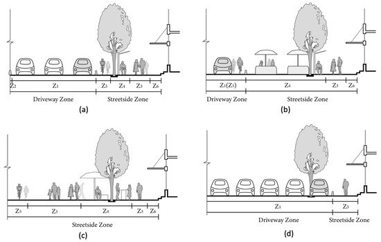
1. Public Right-of-Way of Complete Streets Scheme

In transportation, the public ROW, or the ROW of road space, defines the legal right or the priority of specific types of road users to pass along a route through the street space [1]. These road users include not only motorised vehicles, but also vulnerable groups such as pedestrians and cyclists [2]. The purposes of balancing the ROW include improving traffic efficiency, engaging all modes of transport, and reducing potential inter-mode conflicts [3].
The complete streets scheme has risen as a mainstream engineering solution to balance the ROW [4][5]. It satisfies the basic demands of accommodating all road users with corresponding shares of space, but simultaneously canalise such space as per distinctive modes of travel [6][3]. The complete streets scheme principally comprises a driveway zone and a streetside zone. Figure 1 demonstrates four examples of its ROW plan.
Figure 1. Examples of the Right-of-Way Plans. (a) A common complete street plan. (b) A pedestrians-prioritised plan. (c) A zero-driveway plan. (d) An automobile preferred plan. Note that White Cars indicates cars in the driving mode and grey cars in the on-street parking mode.
Both the driveway and streetside can be further subdivided into different functional sections [7]. For instance, a driveway zone comprises several driving and curb lanes (Z1), and possibly a median (Z2). Meanwhile, a streetside sits between the driveway and private lands, primarily serving non-vehicular mobility and providing accessibility to venues, comprising cycle lanes (Z5) and sidewalks (Z3). It also includes a variety of road facilities in facility belts (Z4), and lively street activities in the front zones (Z6) [8][9].
Due to differences in street functions, locations and throughput capacities, the sectional widths vary significantly [8]. On one hand, roads can be categorised into four types according to their functions: commercial, residential (lanes, mews), landscape (boulevard, parkway) and trafficking. On the other hand, concerning their serving capacity, the ROW can be classed into four grades: main roads, secondary roads, branches, and laneways [10]. For instance, boulevards are landscape-functional main roads, and the commercial avenues are commercial-oriented main roads [11].
Based on a holistic survey of the state-of-the-art available complete streets scheme worldwide, we compared and summarised the following underlying principles of designing a street. First, the sidewalk should be planned no less than 1.5 m, and it is encouraged to be between 2 m and 2.5 m for new development residential streets or downtown commercial streets [9][10][11][12]. Second, the width of a driving lane is considered 3 m to 3.5 m for passenger cars, freight vans and trucks in urban areas. Third, a curb lane is suggested to bear a width of 3 m for on-street parking operations [9]. Fourth, the provision of cycle lanes can be flexible as it could occupy an independent lane with a width between 1.5 m to 2.5 m; Alternatively, driving lanes could accommodate those cycling demands. Fifth, the comprehensive facility belt should at least be assigned with 1.5 m to 2 m in width [9][10]. Finally, any street should secure a clear path in a width of 3.5 m to ensure the operations of emergency vehicles.

2. Challenges Facing Complete Streets Scheme

It is widely acknowledged that the complete streets scheme has achieved seminal contributions with regard to road safety and the operational efficiency of traffic flows [13][14]. However, these rigid and canalised patterns handicap their flexibility and resilience in responding long term’s endogenous and exogenous challenges facing road space.
The endogenous challenges emerge from the priority of usage between vehicles and the other modes of travel. A wide range of planners and geographers have criticised the complete street as ’incomplete plans’ concerning streets as public space [15]. They claimed that street events, pedestrians, e-scooter riders and cyclists should be granted more space than and priority to cars [16]. Temporary measurements, such as closure of driveways in a short period of time [17], and some permanent remedies, like traffic calming [18], shared road surface [19] have firmly responded to such appeal. The recent Covid-19 pandemic also fostered the reclaiming of driveways for non-vehicular traffic operations or as extensions of indoor activities [20]. To take placemaking and urban design into account, such flexibility of road space usage could potentially support diverse street activities and reinforce the public recognition of streets as public space [21].
The prominent exogenous challenges could be the deployment of Autonomous Vehicles (AVs) and Shared Autonomous Vehicles (SAVs) mobility [22]. It is expected that the future urban mobility and goods logistics could be replaced almost entirely by these disruptive modes of transport around 2040 to 2060 [23]. One of the early research jointly conducted by the Boston Consulting Group (BCG) and the World Economic Forum (WEF) found that with a moderate 60% of market penetration, AVs mobility might induce considerable trips to downtown areas during the morning and evening commute peaks. This could overload streets of city centres, raising travel costs by at least 5.5%, while broadly alleviating traffic in suburban neighbourhoods by 12% [24].
An increasing proportion of studies on AV transport demonstrates the disruptive impact of SAVs, which may transform our current transport into the Autonomous Mobility-on-Demand (AMoD) system [25]. By adopting SAVs, it is estimated that 16% of current vehicular fleet could suffice daily mobility [26]. While 85% of current off-street parking space land can be liberated [27], while frequent Pick-Up and Drop-Off (PUDO) events would require more curb parking areas to be installed and efficiently managed [28]. In addition, some emerging new road infrastructures, including the rapid charging facilities, may also disrupt the conventional street functions and demand for new spatial plans to accommodate new ROW desires [29][22].
These potential changes signal the urgency to revisit the current design protocols and renovate road management techniques. With the promising advancement of intelligent and connected road infrastructures, real-time optimal control over ROW might present a novel solution to this problem. Although new methods and algorithms have been developed, with some even tested on roads [30][31], those pioneering practices are still confined within limited road infrastructures, such as traffic signals and roadside units [32][33]. Moreover, the status-quo models and algorithms still fall far short in supporting the dynamic control of public ROW.

3. Performance Metrics Regarding Street Design and Management

Good street space is underpinned by objectives from a broad spectrum of domains [8]. In other words, the design and management of streets usually correspond to a multi-objective decision-making process given a collection of goals [34]. These domains include place-making, health and environmental, connectivity and accessibility, traffic efficiency, construction and maintenance, and safety [8][34], as summarised in Figure 2.
Figure 2. Multi-objectives of Making Sustainable Road Space.
Regarding our study, we first treat users’ safety as the baseline. Namely, the requirement of collision-free was encoded as a priority in our model. Then, among the rest objectives, we approach to balance place-making and transport efficiency, hoping to coordinate traffic engineering and urban planning appeals. On the one hand, evidence proves that suffice the territory of sidewalks can effectively enhance the safety perception of pedestrians, contributing to more comfortable walking experiences, and simultaneously engaging street lives [8][15][18]. On the other hand, the operational efficiency represents a significant indicator measuring the primary trafficking performance of roads [35].

References

  1. Prytherch, D.L. Legal geographies—Codifying the right-of-way: Statutory geographies of urban mobility and the street. Urban Geogr. 2012, 33, 295–314.
  2. Shinar, D. Safety and mobility of vulnerable road users: Pedestrians, bicyclists, and motorcyclists. Accid. Anal. Prev. 2011, 44, 1–2.
  3. McCann, B. Completing Our Streets: The Transition to Safe and Inclusive Transportation Networks; Island Press: Washington, DC, USA, 2013.
  4. Slinn, M.; Matthews, P.; Guest, P. Traffic Engineering Design. Principles and Practice; Taylor & Francis: Milton Park, UK, 1998.
  5. Donais, F.M.; Abi-Zeid, I.; Waygood, E.O.D.; Lavoie, R. Assessing and ranking the potential of a street to be redesigned as a Complete Street: A multi-criteria decision aiding approach. Transp. Res. Part A Policy Pract. 2019, 124, 1–19.
  6. Hui, N.; Saxe, S.; Roorda, M.; Hess, P.; Miller, E.J. Measuring the completeness of complete streets. Transp. Rev. 2018, 38, 73–95.
  7. Keyue, G. Analysis Right-of-Way Concept of Urban Road Width. Urban Transp. China 2012, 10, 62–67.
  8. Dumbaugh, E.; King, M. Engineering Livable Streets: A Thematic Review of Advancements in Urban Street Design. J. Plan. Lit. 2018, 33, 451–465.
  9. National Association of City Transportation Officials. Global Street Design Guide; Island Press: Washington, DC, USA, 2016.
  10. Urban Planning Society of China. Street Design Guideline. Available online: http://www.planning.org.cn/news/uploads/2021/03/6062c223067b9_1617084963.pdf (accessed on 7 April 2021).
  11. National Association of City Transportation Office. Urban Street Design Guide. Available online: https://nacto.org/publication/urban-street-design-guide/ (accessed on 7 April 2021).
  12. Department for Transport, United Kingdom. Manual for Streets. Available online: https://assets.publishing.service.gov.uk/government/uploads/system/uploads/attachment_data/file/341513/pdfmanforstreets.pdf (accessed on 7 April 2021).
  13. O’Flaherty, C.A. Transport Planning and Traffic Engineering; CRC Press: Boca Raton, FL, USA, 2018.
  14. Mofolasayo, A. Complete Street concept, and ensuring safety of vulnerable road users. Transp. Res. Procedia 2020, 48, 1142–1165.
  15. Desai, M. Reforming Complete Streets: Considering the Street as Place. Ph.D. Thesis, University of Cincinnati, Cincinnati, OH, USA, 2015.
  16. Loukaitou-Sideris, A.; Brozen, M.; Abad Ocubillo, R.; Ocubillo, K. Reclaiming the Right-of-Way Evaluation Report: An Assessment of the Spring Street Parklets; Technical Report; UCLA: Los Angeles, CA, USA, 2013.
  17. Wolf, S.A.; Grimshaw, V.E.; Sacks, R.; Maguire, T.; Matera, C.; Lee, K.K. The impact of a temporary recurrent street closure on physical activity in New York City. J. Urban Health 2015, 92, 230–241.
  18. Ewing, R.; Brown, S.J. US Traffic Calming Manual; Routledge: London, UK, 2017.
  19. Hamilton-Baillie, B. Shared space: Reconciling people, places and traffic. Built Environ. 2008, 34, 161–181.
  20. Fischer, J.; Winters, M. COVID-19 street reallocation in mid-sized Canadian cities: Socio-spatial equity patterns. Can. J. Public Health 2021, 112, 376–390.
  21. Beske, J. Placemaking. In Suburban Remix; Springer; Island Press: Washington, DC, USA, 2018; pp. 266–289.
  22. Schlossberg, M.; Millard-Ball, A.; Shay, E.; Riggs, W.B. Rethinking the Street in an Era of Driverless Cars; Technical Report; University of Oregon: Eugene, OR, USA, 2018.
  23. Meeder, M.; Bosina, E.; Weidmann, U. Autonomous vehicles: Pedestrian heaven or pedestrian hell. In Proceedings of the 17th Swiss Transport Research Conference, Ascona, Switzerland, 17–19 May 2017; pp. 17–19.
  24. Moavenzadeh, J.; Lang, N.S. Reshaping Urban Mobility with Autonomous Vehicles: Lessons from the City of Boston; World Economic Forum: New York, NY, USA, 2018.
  25. Javanshour, F.; Dia, H.; Duncan, G. Exploring system characteristics of autonomous mobility on-demand systems under varying travel demand patterns. In Intelligent Transport Systems for Everyone’s Mobility; Springer: Singapore, 2019; pp. 299–315.
  26. Javanshour, F.; Dia, H.; Duncan, G.; Abduljabbar, R.; Liyanage, S. Performance Evaluation of Station-Based Autonomous On-Demand Car-Sharing Systems. IEEE Trans. Intell. Transp. Syst. 2021.
  27. Kondor, D.; Santi, P.; Basak, K.; Zhang, X.; Ratti, C. Large-scale estimation of parking requirements for autonomous mobility on demand systems. arXiv 2018, arXiv:1808.05935.
  28. Zhang, W.; Wang, K. Parking futures: Shared automated vehicles and parking demand reduction trajectories in Atlanta. Land Use Policy 2020, 91, 103963.
  29. Anastasiadis, E.; Angeloudis, P.; Ainalis, D.; Ye, Q.; Hsu, P.Y.; Karamanis, R.; Escribano Macias, J.; Stettler, M. On the Selection of Charging Facility Locations for EV-Based Ride-Hailing Services: A Computational Case Study. Sustainability 2021, 13, 168.
  30. Sabar, N.R.; Chung, E.; Tsubota, T.; de Almeida, P.E.M. A memetic algorithm for real world multi-intersection traffic signal optimisation problems. Eng. Appl. Artif. Intell. 2017, 63, 45–53.
  31. Sánchez-Medina, J.J.; Galán-Moreno, M.J.; Rubio-Royo, E. Traffic signal optimization in “La Almozara” district in Saragossa under congestion conditions, using genetic algorithms, traffic microsimulation, and cluster computing. IEEE Trans. Intell. Transp. Syst. 2009, 11, 132–141.
  32. Yu, B.; Xu, C.Z. Admission control for roadside unit access in intelligent transportation systems. In Proceedings of the 2009 17th International Workshop on Quality of Service, Charleston, SC, USA, 13–15 July 2009; pp. 1–9.
  33. Aragon-Gómez, R.; Clempner, J.B. Traffic-signal control reinforcement learning approach for continuous-time markov games. Eng. Appl. Artif. Intell. 2020, 89, 103415.
  34. Brauers, W.K.M.; Zavadskas, E.K.; Peldschus, F.; Turskis, Z. Multi-objective decision-making for road design. Transport 2008, 23, 183–193.
  35. Vaudrin, F.; Erdmann, J.; Capus, L. Impact of autonomous vehicles in an urban environment controlled by static traffic lights system. Proc. Sumo. Simul. Auton. Mobil. 2017, 81, 81–90.
More
Information
Subjects: Transportation
Contributor MDPI registered users' name will be linked to their SciProfiles pages. To register with us, please refer to https://encyclopedia.pub/register :
View Times: 382
Revisions: 2 times (View History)
Update Date: 28 Dec 2021
1000/1000