Your browser does not fully support modern features. Please upgrade for a smoother experience.
Submitted Successfully!
 +1 credit
Thank you for your contribution! You can also upload a video entry or images related to this topic.
For video creation, please contact our Academic Video Service.
| Version | Summary | Created by | Modification | Content Size | Created at | Operation |
|---|---|---|---|---|---|---|
| 1 | DAVID GROHMANN | + 1355 word(s) | 1355 | 2021-10-29 11:22:44 | | | |
| 2 | Vicky Zhou | Meta information modification | 1355 | 2021-11-10 02:38:51 | | |
Video Upload Options
We provide professional Academic Video Service to translate complex research into visually appealing presentations. Would you like to try it?
Cite
If you have any further questions, please contact Encyclopedia Editorial Office.
Grohmann, D. Urban Greenery as a Complex System. Encyclopedia. Available online: https://encyclopedia.pub/entry/15836 (accessed on 24 June 2026).
Grohmann D. Urban Greenery as a Complex System. Encyclopedia. Available at: https://encyclopedia.pub/entry/15836. Accessed June 24, 2026.
Grohmann, David. "Urban Greenery as a Complex System" Encyclopedia, https://encyclopedia.pub/entry/15836 (accessed June 24, 2026).
Grohmann, D. (2021, November 09). Urban Greenery as a Complex System. In Encyclopedia. https://encyclopedia.pub/entry/15836
Grohmann, David. "Urban Greenery as a Complex System." Encyclopedia. Web. 09 November, 2021.
Copy Citation
A complex system is an open system in a state of dynamic equilibrium. It can also be described as a network connecting the various elements that constitute the system itself. The Urban Green System (UGS) is one such complex system. In this regard, its first characteristic is that it can be described as a network of green elements (areas, linear infrastructures, points) with variable rules governing the connections linked to their main functions in the urban context. Furthermore, it is an open system that exhibits dynamic relationships with all of the other components of the city.
urban green system
urban green network
complex systems
multi-scale approach
demand–supply balancing
attractiveness of cultural services
1. Introduction
Many planners and scholars have studied the relationship between UGS and other components of the city, generally by focusing on a particular variable. For instance, Lahoti et al. [1] studied the UGS’s relationship to the distance from houses, Artman et al. [2] from care facilities, Biernacka et al. [3] from roads, Chen and Chang [4] from public transport stops, and Zhu et al. [5] from points of interest in a city. Other studies examined the relationship between the UGS and other urban land covers [6], landscape patterns [7], urban zoning [8], and socio-demographic variables [9]. Scholars have also studied links between the UGS and other city infrastructures [10], including grey infrastructures [11] and other urban open spaces [12], such as urban squares [13]. These evaluations too often consider the UGS to be a homogeneous system. In reality, even without external intervention, the UGS is composed of many living elements (trees, shrubs, herbs, small animals, and users), which change throughout their life; as a consequence, the system also continuously changes and does so at different speeds depending on its constituent variables [14]. Furthermore, the nature of the internal and external linkages is nonlinear [15] and some of them are, therefore, unpredictable and, to a certain extent, unknown [13]. Menconi et al. [16] demonstrated that every action in a single green area changes the equilibrium of the system and can, thus, result in active synergies or conflicts with other elements of the UGS or with external variables.
For this reason, local administrators and urban planners require methods that are able to take into account all of the complexities of the UGS in their planning and design.
2. Highlights of the Method in Considering the Complexity of the UGS
The first core theme when considering urban green systems is the adoption of a multi-level approach. Urban green planners need a holistic understanding of relevant multi-spatial and multi-temporal scales to observe urban phenomena from multiple viewpoints. Herein developed a method to combine the CES requests of citizens for green areas with the evaluations of experts. The method uses five criteria applied at scales of ever greater detail to understand the synergies, conflicts, and complementary factors between the CES provided by UGS. In urban green infrastructure planning, Elliot et al. [17] suggested considering city-level goals and local-level benefits separately. Following their suggestions, herein used the criteria of availability and accessibility at the city level, the criterion of attractiveness at the neighborhood level (the catchment area), and the criteria of usability and suitability at the green area level. At the city level, herein used data from a census and OpenStreetMap. Herein relied on satellite images and field research at the neighborhood level, and, at the green area level, we conducted field research. The utility of the proposed system of criteria depends on the availability of data [3]. Herein used the municipal urban green census of the city of Perugia [18] as the main source of information.
The second core theme when considering urban green systems is the value of network analysis. Data from OpenStreetMap are free, and the process of their acquisition is simple and, to a large extent, automatic using GIS software [19]. At the same time, great effort was made to edit and organize the network and revise the classifications of roads. The barriers listed in these data are stairs, fast roads, and multi-lane crossings. Herein conducted further field research to verify other barriers (uneven sidewalks, slopes, fences, dangerous surroundings). Using safe roads, herein evaluated the distances between green areas and residences. With all these data, our method calculates the catchment areas of every green space as the population living a maximum of a 15-min walk away using only safe roads without barriers. The results confirm previous findings [4][6][20] that indicated network analysis is an effective approach to investigate interactions between variables. To achieve satisfactory results, we outlined the necessity of verifying the effectiveness of the available dataset and, eventually, editing it.
The criterion of accessibility outlines a third core theme when considering urban green systems: the need to evaluate the relationships that exist between the UGS with the external variables of the system. In line with the studies of other scholars [1][21][20], herein used housing as an external variable. Other authors investigated the external relationships between the UGS and landscape patterns [7], land cover [22], urban infrastructure [11], other public spaces [13], public transport [4], and points of interest [5]. These authors considered the UGS to be composed of homogeneous variables without evaluating its internal heterogeneity, while our method considers this heterogeneity to compare different areas within the UGS.
This observation brings us to the fourth core theme when considering urban green systems: the need to evaluate the relationships between the internal variables of the system. Indeed, the UGS comprises extremely diverse areas providing a collection of CES interacting locally with each other in multiple ways [20]. Innovative approaches to urban green planning require solutions that evaluate the relationships between different areas of the UGS in regard to CES provision, such as which activities are catered to and in which spatial relations [23][24]. In the method, once the area was selected (x1 in Figure 1), we used attractiveness and usability criteria to evaluate the relationships between it and other green areas. Herein used Google Images to realize a timely census of furniture and equipment, and then, similar to Biernacka et al. [3], conducted field visits. Only during these visits did we recognize the actual condition of the equipment and surroundings, and understand the real character of public events (concerts, festivals, open markets, sports events, etc.) held in the UGS to determine whether they might act as an attraction or a deterrent to prospective users. The second criterion used to evaluate relationships between green areas is their “usability”. This criterion is useful to understand if there is already underused equipment in other green areas that could benefit from increased use. This method evaluates alternative solutions before installing new equipment, thereby improving the efficiency of resource provision by public administrations. Therefore, this method could help to address the institutional barrier to improving the UGS due to a lack of funds [25]. Popular times, wait times, and visit duration data from Google Maps reveal which green areas received visits from the users [26] but do not report on the use of equipment. For this reason, we conducted field research to verify the spaces’ suitability for physical distancing. This field research can be time-consuming for everyone involved [23], but provides an in-depth understanding of the use of equipment. Findings are often limited in duration and frequency because users continuously change their activities [9]. For instance, during the COVID-19 pandemic, many scholars have indicated that the use of green areas has strongly increased [27][28][5][29][30], but constant monitoring is necessary to evaluate whether these demands will remain as high. For example, Derks et al. [31] demonstrated that visits to an urban forest in Bonn (Germany) dropped to pre-COVID levels after restrictions were lifted.
A fifth core theme is the need for a continuous evaluation of site-specific and community-led solutions using strategies of adaptation. Indeed, our method searches for solutions differentiated by green areas, type of equipment, and inhabitants of the neighborhoods. The flowchart presented in Figure 2 has loops to revise GIS data based on the new solutions implemented. As suggested by Foster [32], the developed method uses a complex systems approach combining divergent steps (building of dataset with information on internal and external variables) and convergent steps (analyzing and evaluating all relevant information to assist in making final decisions).
 Figure 1. Steps of the method at the city level.
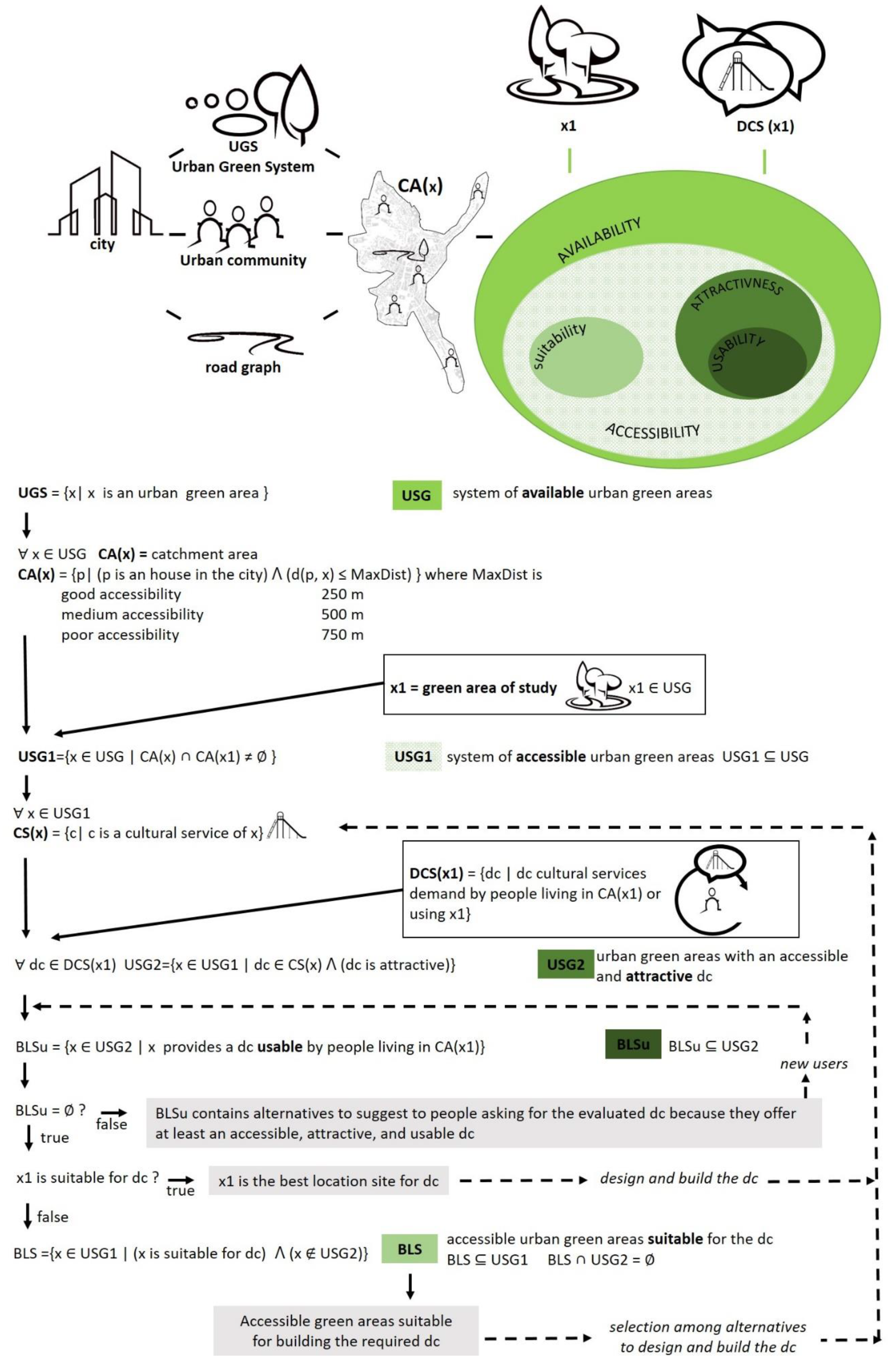 Figure 2. Steps of the method at the neighborhood and green area levels.
References
- Lahoti, S.; Lahoti, A.; Saito, O. Benchmark assessment of recreational public Urban Green space provisions: A case of typical urbanizing Indian City, Nagpur. Urban For. Urban Green 2019, 44.
- Artmann, M.; Mueller, C.; Goetzlich, L.; Hof, A. Supply and Demand Concerning Urban Green Spaces for Recreation by Elderlies Living in Care Facilities: The Role of Accessibility in an Explorative Case Study in Austria. Front. Environ. Sci. 2019.
- Biernacka, M.; Kronenberg, J.; Łaszkiewicz, E. An integrated system of monitoring the availability, accessibility and attractiveness of urban parks and green squares. Appl. Geogr. 2020, 116.
- Chen, J.; Chang, Z. Rethinking urban green space accessibility: Evaluating and optimizing public transportation system through social network analysis in megacities. Landsc. Urban Plan. 2015, 143, 150–159.
- Zhu, J.; Xu, C. Sina microblog sentiment in Beijing city parks as measure of demand for urban green space during the COVID-19. Urban For. Urban Green 2020, 58.
- Wanghe, K.; Guo, X.; Luan, X.; Li, K. Assessment of Urban Green Space Based on Bio-Energy Landscape Connectivity: A Case Study on Tongzhou District in Beijing, China. Sustainability 2019, 11, 4943.
- Wang, B.; Liu, Z.; Mei, Y.; Li, W. Assessment of Ecosystem Service Quality and Its Correlation with Landscape Patterns in Haidian District, Beijing. Int. J. Environ. Res. Public Health 2019, 16, 1248.
- Mahmoudkhani, M.; Feghhi, J.; Makhdoum, M.; Bahmani, O. Evaluation of the recreational capability and designing of the woodsy promenade. Environ. Dev. Sustain. 2020, 23, 8062–8075.
- Dade, M.C.; Mitchell, M.G.; Brown, G.; Rhodes, J.R. The effects of urban greenspace characteristics and socio-demographics vary among cultural ecosystem services. Urban For. Urban Green 2020, 49.
- Hong, W.; Guo, R. Indicators for quantitative evaluation of the social services function of urban greenbelt systems: A case study of shenzhen, China. Ecol. Indic. 2017, 75, 259–267.
- Schäffler, A.; Swilling, M. Valuing green infrastructure in an urban environment under pressure The Johannesburg case. Ecol. Econ. 2013, 86, 246–257.
- Subramanian, D.; Jana, A. Evaluating the cultural ecosystem services of India: Comparison of budget allocations to improve the use value of recreational open spaces. Ecosyst. Serv. 2019, 38.
- Cilliers, E.J.; Timmermans, W.; Goorbergh, F.V.D.; Slijkhuis, J.S.A. The Story Behind the Place: Creating Urban Spaces That Enhance Quality of Life. Appl. Res. Qual. Life 2014, 10, 589–598.
- Matasov, V.; Marchesini, L.B.; Yaroslavtsev, A.; Sala, G.; Fareeva, O.; Seregin, I.; Castaldi, S.; Vasenev, V.; Valentini, R. IoT Monitoring of Urban Tree Ecosystem Services: Possibilities and Challenges. Forests 2020, 11, 775.
- Ferrini, F.; Fini, A.; Mori, J.; Gori, A. Role of Vegetation as a Mitigating Factor in the Urban Context. Sustainability 2020, 12, 4247.
- Menconi, M.; Tasso, S.; Santinelli, M.; Grohmann, D. A card game to renew urban parks: Face-to-face and online approach for the inclusive involvement of local community. Eval. Program Plan. 2019, 79.
- Elliott, R.M.; Motzny, A.E.; Majd, S.; Chavez, F.V.; Laimer, D.; Orlove, B.S.; Culligan, P.J. Identifying linkages between urban green infrastructure and ecosystem services using an expert opinion methodology. Ambio 2019, 49, 569–583.
- Municipality of Perugia. Municipal Census of Urban green areas (Portale Ambiente). Available online: http://ambiente.comune.perugia.it/#Temi%20Ambientali (accessed on 5 September 2021).
- Ramn, F.; Topf, J.; Chilton, S. OpenStreetMap—Using and Enhancing the Free Map of the World; UIT Cambridge Ltd.: Cambridge, UK, 2014.
- Gerstenberg, T.; Baumeister, C.F.; Schraml, U.; Plieninger, T. Hot routes in urban forests: The impact of multiple landscape features on recreational use intensity. Landsc. Urban Plan. 2020, 203.
- Akpinar, A. Factors influencing the use of urban greenways: A case study of Aydin, Turkey. Urban For. Urban Green 2016, 16, 123–131.
- Boulton, C.; Dedekorkut-Howes, A.; Byrne, J. Factors shaping urban greenspace provision: A systematic review of the literature. Landsc. Urban Plan. 2018, 178, 82–101.
- Heikinheimo, V.; Tenkanen, H.; Bergroth, C.; Järv, O.; Hiippala, T.; Toivonen, T. Understanding the use of urban green spaces from user-generated geographic information. Landsc. Urban Plan. 2020, 201.
- Menconi, M.E.; Palazzoni, L.; Grohmann, D. Core themes for an urban green systems thinker: A review of complexity man-agement in provisioning cultural ecosystem services. Urban For. Urban Green 2021, 127355.
- Biernacka, M.; Kronenberg, J. Classification of institutional barriers affecting the availability, accessibility and attractiveness of urban green spaces. Urban For. Urban Green 2018, 36, 22–33.
- Support Google. Available online: https://support.google.com/business/answer/6263531?hl=en# (accessed on 5 September 2021).
- Sharifi, A.; Khavarian-Garmsir, A.R. The COVID-19 pandemic: Impacts on cities and major lessons for urban planning, design, and management. Sci. Total Environ. 2020, 749.
- Honey-Rosés, J.; Anguelovski, I.; Chireh, V.K.; Daher, C.; Bosch, C.K.V.D.; Litt, J.S.; Mawani, V.; McCall, M.K.; Orellana, A.; Oscilowicz, E.; et al. The impact of COVID-19 on public space: An early review of the emerging questions—Design, perceptions and inequities. Cities Health 2020.
- Ugolini, F.; Massetti, L.; Calaza-Martínez, P.; Cariñanos, P.; Dobbs, C.; Ostoić, S.K.; Marin, A.M.; Pearlmutter, D.; Saaroni, H.; Šaulienė, I.; et al. Effects of the COVID-19 pandemic on the use and perceptions of urban green space: An international exploratory study. Urban For. Urban Green 2020, 56.
- Ma, A.T.; Lam, T.W.; Cheung, L.T.; Fok, L. Protected areas as a space for pandemic disease adaptation: A case of COVID-19 in Hong Kong. Landsc. Urban Plan. 2020, 207.
- Derks, J.; Giessen, L.; Winkel, G. COVID-19-induced visitor boom reveals the importance of forests as critical infrastructure. For. Policy Econ. 2020, 118, 102253.
- Foster, K. Geodesign parsed: Placing it within the rubric of recognized design theories. Landsc. Urban Plan. 2016, 156, 92–100.
More
Information
Contributor
MDPI registered users' name will be linked to their SciProfiles pages. To register with us, please refer to https://encyclopedia.pub/register
:
View Times:
810
Revisions:
2 times
(View History)
Update Date:
10 Nov 2021
Table of Contents


Notice
You are not a member of the advisory board for this topic. If you want to update advisory board member profile, please contact office@encyclopedia.pub.
OK
Confirm
Only members of the Encyclopedia advisory board for this topic are allowed to note entries. Would you like to become an advisory board member of the Encyclopedia?
Yes
No
${ textCharacter }/${ maxCharacter }
Submit
Cancel
Back
Comments
${ item }
|
${ item.createdUser.fullName }
${ item.createdAt }
${ item.vote }
${ item.reply }
Delete
${ reply.createdUser.fullName }
${ reply.createdAt }
${ reply.vote }
Delete
There is no reply to this comment~
${ item.replyTextCharacter }/${ item.replyMaxCharacter }
Submit
Cancel
More
No more~
There is no comment~
${ textCharacter }/${ maxCharacter }
Submit
Cancel
${ selectedItem.replyTextCharacter }/${ selectedItem.replyMaxCharacter }
Submit
Cancel
Confirm
Are you sure to Delete?
Yes
No