Knowledge about marine circulation and its variability is a basic requirement for the correct management of activities aimed at exploiting marine resources and for the prevention and eventual mitigation of the risks involved. The activities of the Marine Hazard Project, to which this special number of Sustainability is dedicated, focus on geothermal resources connected with some submerged volcanic systems located in the Tyrrhenian Sea. This sea hosts delicate coastal and marine ecosystems, and is characterized by rich dynamics, both driven by the interaction of the local forcing with the complex morphology and bathymetry of the basin, and by exchanges with adjacent sub-basins which take place at all depths.
1. Introduction
The coastal areas of the Tyrrhenian Sea—the main Italian sea, TYS hereafter—host delicate environments that are under pressure deriving from climate change and from the impacts of human activities. The latter may be amplified by local circulation features that can act as attractors of marine litter, or can disperse coastally released pollutants, endangering the local ecosystems, even in protected areas (see, e.g., the recent works
[1][2], focusing on the Ligurian Sea, where the Pelagos Sanctuary for marine mammals is located). Detailed knowledge of marine circulation is therefore required for correct management of the socio-economic activities insisting on coastal areas, as well as for the planning of future activities aiming at the exploitation of marine resources, in order to understand, prevent, and eventually mitigate the risks involved. This needs to be achieved in the context of an evolving scenario, since important modifications of the hydrological properties of the TYS and, more generally, of the whole Mediterranean Sea, have been observed in the last few decades, whose impacts on circulation still need to be clarified (see, e.g.,
[3], about the Mediterranean surface warming trend, and
[4], pointing out a strong increase of the salt content in the western Mediterranean since 2005).
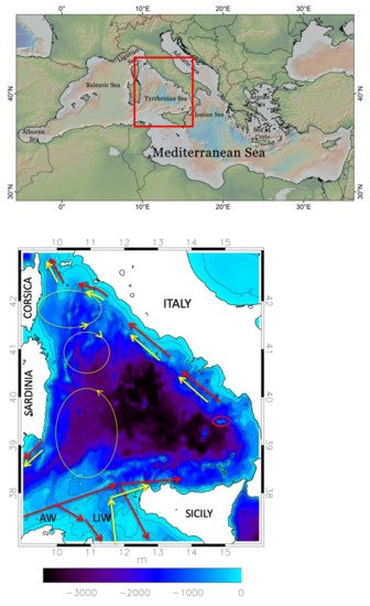
The understanding of the TYS circulation is also hindered by the complex structure of the basin itself. The lower panel of displays the bathymetry of the TYS and shows its three main openings, the Corsica and Sardinia Channels (to the north and southwest, respectively), connecting the TYS to the westernmost part of the western Mediterranean, and the Sicily Strait (to the south), through which the western Mediterranean communicates with the eastern sub-basin, or Levantine basin. The TYS circulation is strongly affected by complex exchanges that take place at all depths through these openings, whose characterization has been—and still is—a key issue from an observational point of view. Smaller openings that strongly influence the surrounding circulation include the Bonifacio Strait, the narrow passage between Corsica and Sardinia, to the east of which a permanent dipole is located (Bonifacio dipole, with the cyclonic pole to the north; see the yellow ovals in ), and the Messina Strait, between Sicily and the southern part of Italy, an area characterized by strong tidal currents. The red oval in highlights the region of the Palinuro Seamount, which is of direct interest for the Marine Hazard Project because of the hydrothermal systems present in the area, and of the associated mineral deposits (see
[5], and references therein).
Figure 1. Top panel: the red box indicates the position of the Tyrrhenian Sea inside the Mediterranean basin. Lower panel: geometry and bathymetry (colours) of the Tyrrhenian Sea. The yellow ovals on the left schematically indicate three permanent structures of the basin circulation, the two poles of the Bonifacio dipole to the north, and a wide cyclonic area between Sardinia and Sicily. The arrows indicate the paths inside the basin of the Atlantic Water (AW; red) entering from the Sardinia Channel, and of the Levantine Intermediate Water (LIW; yellow) that enters from the Sicily Strait. The small red oval encompasses the Palinuro Seamount, to the southwest of which the Marsili Seamount can be recognized.
The hydrology and the dynamics of the TYS have been studied for a long time, and the large-scale picture resulting from the experimental campaigns of the 20th century has been summarized in several classical works
[6][7][8][9]. In the present review, we mostly focus on the main developments from the last decade, which have led to a more detailed description of the TYS circulation and of its variability. For a short synopsis of previous investigations, the reader can refer to the introduction of
[10], a paper that assesses the variability of the TYS surface circulation, mostly based on the analysis of satellite altimeter data. The synopsis includes some interesting works
[11][12] in which simplified, barotropic models of the dynamics were used to study the relation between the structure of the large-scale circulation and that of wind-forcing, and numerical investigations performed with the first, relatively coarse-resolution, general circulation models (GCMs) implemented over the Mediterranean Sea
[13][14].
During the 1990s, the observation landscape was enriched by the advent of systematic satellite measurements, revealing rich mesoscale dynamics that could not be adequately resolved by the aforementioned GCMs
[15]. This has allowed for the construction of archives of several ocean physical parameters, such as the sea surface temperature (SST), the absolute dynamic topography (ADT; derived from altimeter measurements), with the associated reconstruction of the geostrophic circulation, and the turbidity, with spatial details going from about 1 km for the latter to about 14 km (1/8°) for the altimeter data.
In the last decade, the use of these datasets in the Mediterranean context has increased (see
[10][16][17], among others). The analysis of the altimeter and SST data has provided key insights about the structure of the circulation and its variability, which takes place on a variety of time-scales, ranging from seasonal to interannual, and to even longer scales associated with the global thermohaline cell of the Mediterranean. The observed interannual variability can be related to the atmospheric variability, but may also be an expression of internal, sub-basin dynamics (e.g., the NIG oscillation taking place in the northern portion of the Ionian Sea; see
[18], and references therein).
These observations, however, only give information about the sea surface (SST), or the first few tens of meters of the water column (turbidity), or, in the case of altimeter data, about the surface layer. The latter extends from the sea surface down to the pycnocline, the narrow layer characterized by a strong density gradient that separates the surface water of Atlantic origin (Atlantic water, AW; upper 150 m), from the underlying intermediate water, which originates in the Levantine basin.
The satellite measurements are part of a large archive managed since 2015 by the European Copernicus Programme (for the sea, the Copernicus Marine Environment Monitoring Service; CMEMS), which includes both remote and In Situ observations. Useful information on the surface and intermediate layers, until depths of 700–800 m, is also provided by other observation programs, such as the temperature measurements by XBTs (eXpendable BathyThermographs) carried out by opportunity ships on some commercial sea lanes
[19], and the surface drifter and profiling float measurements made by OGS (National Institute of Oceanography and Applied Geophysics), in the context of ARGO-ITALY
[20]. Observations of the deepest layers are unfortunately rarer.
2. The Tyrrhenian Water Masses
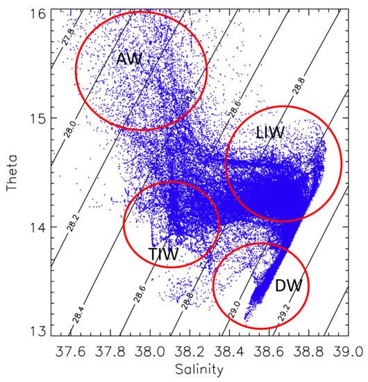
From a hydrological point of view, the TYS is characterized by the presence of three main water masses: the AW, the LIW, and the WMDW. The AW, formerly denoted as Modified Atlantic Water (MAW), before the Mediterranean Science Commission (CIESM), in 2001, established the official acronyms currently used, and forms the surface layer (0–150 m). The Levantine Intermediate Water (LIW) occupies the layer between 200 m and 700 m of depth, whereas the Western Mediterranean Deep Water (WMDW) goes from about 1000 m of depth to the bottom. Besides these main water masses, there is also the Tyrrhenian Intermediate Water (TIW), which is located between the AW and the LIW, and the Tyrrhenian Deep Water (TDW), which is found in the range between 700 m and 1500 m of depth. Temperature salinity (TS) diagrams, obtained from Argo data covering the period 2004–2017, are shown in , where red circles highlight the different water masses, characterized by distinctive hydrological signatures (similar diagrams were presented in
[21]).
Figure 2. Temperature-salinity (T-S) diagram for the Tyrrhenian Sea, obtained from Argo measurements covering the period 2004–2017 (T in °C, S in psu). The red circles highlight the regions occupied by the main water masses. TIW and DW denote the Tyrrhenian Intermediate Water and the Deep Water, respectively.
2.1. Surface and Intermediate Waters
The surface water mass of the TYS is identified by the minimum salinity, and results from the inflow of AW in the south-western part of the Mediterranean basin, through the Gibraltar Strait. The horizontal distribution of salinity in this layer is characterized by a strong meridional gradient, with values ranging from about 36.2 psu in the southern region, in the Sardinia Channel, to 38.2–38.4 psu in the northern part of the TYS, in the region of the Bonifacio dipole, where important processes of vertical mixing take place. This distribution also exhibits a marked seasonal cycle, which we will discuss later in the paper.
The intermediate water masses, the LIW and the TIW, have different origins, because the first comes from the Levantine basin, and enters the TYS through the Sicily Channel (see the yellow arrows in the scheme of ), whereas the second is of local origin, as it has been conclusively shown in
[21]. The TIW is found between the AW and the LIW, in the range 100–200 m, and is characterized by a local temperature minimum, whereas the LIW occupies a deeper and wider layer (200–700 m), and is characterized by local maxima of temperature and salinity in the TS diagram (see ), with values in the ranges 14–14.5 °C and 38.6–38.8 psu, respectively. The TIW is present in most of the TYS, and originates from local winter convection processes
[21][22][23]. It has similar characteristics to those of the Western Intermediate Water (WIW), which is formed in winter in the Liguro-Provençal and Algerian basins. Winter convection in the TYS is particularly strong in the area of the Bonifacio cyclone, where the mixing induces a homogenization of the water column until a depth of about 400 m.
As far as the horizontal distribution of the LIW is concerned, three distinct regions can be identified: one, near the Sicily Channel, which is the region with maximum values of salinity, and is characterized by the strong mixing among the LIW, inflowing through the channel sills, and less dense local waters (e.g.,
[24]); a central region, in which horizontal exchanges are prevalent; and the northern region, where, as for the surface waters, strong vertical mixing takes place, strongly reducing the local values of salinity.
2.2. Deep Waters
Below 1000–1500 m there is the WMDW, which is formed during the processes of deep convection in the Gulf of Lion, and more generally in the Liguro-Provençal basin, and enters the TYS after crossing the Sardinia Channel. Between the LIW and the WMDW there is the TDW
[22][25], a local water mass resulting from the mixing of the LIW with resident deep water, which is characterized by a relative minimum of dissolved oxygen, and has temperature and salinity slightly higher (by about 0.2 °C and 0.03 psu) than those of the WMDW. This water is exported into the western part of the western Mediterranean through the Sardinia Channel.
An important feature of the TYS deep waters is represented by the staircase structures that are observed in the temperature and salinity profiles (see, e.g., Figure 1 of
[26]). These structures are typical of the transition region between LIW and deep water (e.g.,
[26][27]), and result from phenomena of double diffusion. Double diffusion in the ocean is a convective overturning motion driven by the difference in magnitude between the molecular diffusion coefficients for heat and salt, which depends on the vertical gradients of temperature and salinity. When both gradients are positive (warm and salty water overlying colder and fresher), it is called “salt finger convection”, and this is typically the phenomenon occurring in the Tyrrhenian Sea.
3. Surface Circulation
The description of the Tyrrhenian water masses of the previous section has also highlighted the complexity of the exchanges occurring through the three main openings of the TYS. These are sometimes associated to robust, spatially well-defined currents, which, together with the atmospheric forcing at the air-sea interface, play a key role in determining the structure of the surface circulation. One of these currents is the strong AW surface stream that, after following the African coastline, crosses the southern part of the Sardinia Chanel and bifurcates twice before reaching Sicily (see the path schematically indicated by the red arrows in ). Two branches cross the Sicily Strait, the so-called Atlantic Tunisian Current and Atlantic Ionian Stream (see
[28][29], a recent study of the circulation variability in the region), whereas the remaining current, from late autumn to the beginning of spring, enters the TYS. The latter stream then makes a wide cyclonic path along the Sicilian and Italian coasts, and finally outflows into the Ligurian Sea through the Corsica Channel; only a small fraction of it recirculates towards the south, exiting through the northern part of the Sardinia Channel. The results of
[30] indicate that in winter 2004, the transport associated to the current entering from the Sardinia Channel was of about 2 Sv, whereas that associated to the branch that enters the TYS and then exits at Corsica was of about 1 Sv. The latter is also a typical average winter value of the transport through the Corsica Channel, estimated from the current measurements performed since 1985 at a mooring in the sill of the channel
[31][32].
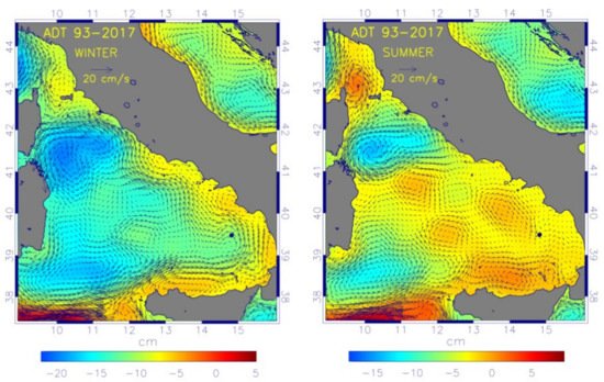
As shown in
[10][33], a more detailed picture of the TYS surface circulation can be obtained from the analysis of altimeter maps (produced by AVISO, and now distributed by CMEMS), which have a spatial resolution of 1/8° (about 14 km) over the Mediterranean Sea (twice the detail of the maps for the global ocean). The merged and delayed maps are particularly useful, because they result from the off-line elaboration of data from all the available tracks. We have used these maps, which now have daily frequency, to produce seasonal means of the ADT for winter and summer, averaged over 25 years (1993–2017). These average maps, shown in , are similar, but not identical, to analogous maps displayed in Figure 4 of
[10], obtained using an older version of the altimeter dataset, covering a shorter period. In , colours denote the ADT values, and geostrophic reconstructions of the circulation, also provided by AVISO, have been superimposed to the ADT maps. The dark dot in the south-eastern part of the basin, centred at (39.48° N, 14.82° E), approximately corresponds to the highest portion of the central edifice of the Palinuro Seamount, which is the most extended and taller, with a summit at about 80 m from the sea surface (see
[34][35] for a detailed description of the bathymetry in the area). We recall that the Palinuro volcanic system is oriented almost zonally, and extends for more than 1/2° in longitude and about 1/4° in latitude.
Figure 3. Average ADT maps (1993–2017) over the Tyrrhenian Sea, for winter (left) and summer (right), with the associated geostrophic circulations superimposed. The dark dot in the south-eastern part of the basin marks the location of the central edifice of the Palinuro Seamount.
3.1. Seasonal Variability
The permanent circulation structures in the western TYS, schematically indicated by yellow ovals in , are readily recognized in the maps of . To the north is the Bonifacio dipole
[11][36], driven by the year-long westerly winds blowing over the Bonifacio Strait. To the south, a wide cyclonic area between Sardinia and Sicily, already present in the circulation schemes of Krivosheya
[6], summarizing the results of Russian experimental campaigns of the preceding decades. In winter, these structures are inserted in a global cyclonic cell that is sustained by wind-forcing, which is cyclonic over most of the basin. The surface current previously described, circulating along the Sicilian and Italian coasts, forms meanders that indicate the presence of an instability
[10]. In the transition between winter and spring, this leads to the formation of anticyclones along the coast and cyclones on the offshore side of the current, similarly to what has been observed in other regions of the Mediterranean, such as the Algerian basin (see, e.g.,
[37][38], where the evolution of anticyclonic eddies forming between the AW current and the Algerian coast is analysed).
One of the meanders is in the area of the Palinuro Seamount, with the current apparently turning cyclonically around the central edifice of the volcano. Considering the dimensions of the latter, and the proximity of its summit to the sea surface, it cannot be excluded that the geostrophic reconstruction of the circulation is here capturing an effect related to the presence of the seamount. Analogous flow patterns in the area are present in the maps of the circulation at a depth of 10 m (March 2009) shown in Figure 8 of
[10]. These maps, which illustrate the development of the instability, derive from the outputs of a high-resolution (horizontal grid spacing of about 2 km) numerical model of the TYS circulation.
The map on the right in shows that the summer circulation is quite different from the winter one. The region between the northern end of Corsica and the Elba Island is now occupied by an anticyclone, denoted as the Ligurian anticyclone in
[19], which appears to separate the TYS circulation from that of the Ligurian Sea (see
[2], and references therein). This is consistent with the fact that the observed transports through the Corsica Channel are typically very small in summer.
At the same time, in the southern TYS, the AW stream coming from the Sardinia Channel only feeds the branches veering towards the Levantine basin, while very little flow appears to enter the eastern TYS, which remains basically isolated. This allows the anticyclonic eddies formed near the coast in spring to grow, becoming dominant elements of the local circulation, also sustained by the strengthening of the negative wind-stress curl pole present to the north of Sicily
[10]. One of these structures is located in front of the Campania region, and extends until the Palinuro Seamount, which, together with the adjacent Marsili Seamount, also appears to have a direct effect on the circulation in this case, delimitating the extension of the cell towards the southeast.
To conclude this description of seasonality, we may briefly highlight the effects of the surface circulation on the spatial distribution of the tracers, and particularly of the salinity. Figure 5.11 of
[39] shows the distribution of the minimum of salinity in winter and summer, obtained from high-resolution simulations of the TYS circulation. In winter (left panel), the lowest values of the salinity minimum inside the TYS are in the region interested by the AW current that circulates along the Italian coasts, and slowly increase along the path of the current, indicating that the AW is not subject to strong mixing along this path. On the other hand, much higher values are found in the western part of the TYS, where the presence of the cyclonic circulations induces vigorous mixing with the intermediate waters
[7][21][39]. In summer, minimum values of salinity are found in the whole eastern part of the basin, where no strong current is present. These numerical findings are consistent with the picture previously developed from the observations
[7].
3.2. Coastal Dynamics in the Central TYS
Since the Palinuro Seamount is not far from the Italian coast and, in particular, from the coasts of Campania, it is natural to wonder whether this area has been included in some regional studies of coastal circulation. The answer appears to be negative, but the circulation along the Campania coasts has attracted considerable attention in the last decade. Of course, the hotspot in the area is represented by the Gulf of Naples, because of the local, intense socio-economic activities; the dynamics and the ecosystems in the area have been monitored and studied for a long time (see the review
[40]). The variability of the circulation in the Campania coastal area, which includes the Gulf of Naples, together with the Gulf of Gaeta (to the north) and that of Salerno (to the south), has been investigated in
[41] (see also references therein), using a very high-resolution numerical model, nested with a TYS circulation model. An important point emerging from this work is that, besides the atmospheric forcing, the interaction with the offshore circulation also plays an important role in shaping the local dynamics. The circulation in the three gulfs is mostly controlled by the local wind stress in autumn and winter, whereas the interaction with the offshore large-scale circulation and baroclinic effects related to topographic variations are important during spring and summer.
Unfortunately, the area of the Palinuro and Marsili Seamounts is out of the computational domain of these works, more to the southeast, and is likewise not reached by the experimental transect, going from the Gulf of Naples to a central location of the TYS, along which repeated hydrological measurements have been collected during the VECTOR Project
[42]. Information on the circulation in the area could, in principle, be obtained from the analysis of the outputs of the Mediterranean Sea circulation forecast model available through CMEMS, but no such study appears to have been conducted so far.
4. Intermediate and Deep Circulation
Until the beginning of the present century, knowledge about the intermediate and deep circulations of the TYS was mostly based on hydrological observations (see
[9]), and on the current measurements at the straits. More recently, a description of the intermediate circulation of the Mediterranean Sea based on the analysis of Argo drifter data has been proposed in
[43], but as far as the TYS is concerned, this description appears similar to the picture that had previously been drawn, in which the large-scale intermediate circulation is basically characterized by a cyclonic path along the coasts of the basin (see, e.g., the scheme in Figure 3 of
[9]). As a matter of fact, the path of the LIW inside the TYS has been unclear for long time. One of the rare dedicated experimental works that has contributed to its clarification is
[44], in which measurements from cruises performed between February 1988 and August 1990 were analysed. In that work, evidence was found of the presence of a LIW current flowing anticlockwise along the coasts of Latium (central Italy), at depths between 250 and 700 m, particularly strong in winter. The signature of this current, as a local maximum in salinity, has also been found more to the south, along the VECTOR transect
[42]. The presence of LIW in the outer portion of the Gulf of Naples has been known for decades
[45].
A weak, and not well-structured LIW average flow (between 200 and 300 m) was found in the re-analysis of the Mediterranean circulation discussed in
[46]. Marked seasonal variations were instead highlighted in
[39], analysing the 2009 circulation patterns from a high-resolution operational forecast model of the TYS. We have performed a similar analysis using forecasts produced by the MITO model (forecasts can be found on the website
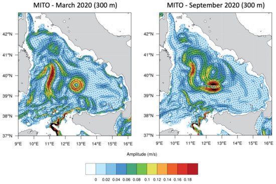
https://giotto.casaccia.enea.it/mito/ (accessed on 16 April 2021)), a recently developed, high-resolution, tide-including operational model of the whole Mediterranean Sea—Black Sea system
[47]. The panels in display the average currents at 300 m, for March and September 2020, obtained from the MITO forecasts.
Figure 4. Intermediate TYS circulation (300 m of depth) for March and September 2020, from MITO forecasts (see the text for details).
The March current patterns are similar to those for February 2009 shown in
[39], with a robust stream of LIW that enters the TYS from the Sicily Channel, and then veers towards the east, proceeding cyclonically all along the Italian continental shelf, until the Corsica Channel. The structure of the circulation has strong similarities with that of the surface winter circulation produced by the model (not shown), with the main large mesoscale features (e.g., the Bonifacio dipole, and the cyclonic circulation to the south of it) present in both layers, indicating the presence of a robust barotropic component of the basin dynamics, similarly to what was found in
[39]. It can be noted that a fraction of the LIW current entering from the Sicily Channel appears to be entrapped in the wide cyclonic area between Sardinia and Sicily, and slowly transported towards the Sardinia Channel. The September circulation map is characterized by a much more direct LIW path towards the northwest, heading for the Sardinia Channel; the LIW cannot penetrate in the southeastern part of the TYS, where a wide anticyclonic circulation is present, similarly to what happens in the surface layer.
This strong difference between the winter and summer intermediate circulations is further highlighted in Figure 7 of
[39], displaying the spatial distributions of the salinity maximum over the water column obtained from the model, for February and September 2009.
By contrast, little is known about the deep circulation (below 1000 m) of the TYS, except for the fact that it should be mainly determined by the transport of WMDW coming from the Algerian basin through the Sardinia Channel. In the absence of direct current measurements, hypotheses have been formulated
[8] based on hydrological observations, which lead to a scheme of the deep circulation similar to that for the intermediate circulation, characterized by a cyclonic path along the coasts of the basin, controlled by the topography. Recent work
[48] indicates that bottom currents may have an important role in shaping the spatial distribution of bottom sediments and microplastics in the northern TYS.
We finally recall that the first description of the deep circulation in the western part of the western Mediterranean Sea has recently been provided in
[49]. This study, based on the analysis of data from profiling floats drifting at depths of 1200 and 1900 m for the period 1997–2002, revealed a rich dynamical structure that still has uncertainties, but can be considered as a first step in the characterization of deep circulation processes in this portion of the Mediterranean basin.
 +1 point