
With this entry we try to provide some remarks on the concept of fragility in the broad context of the urban studies. Some fundamental issues are involved in such a concept when it matches the social-economic and human-urban dimensions particularly, the structural internal contradictions affecting the most vibrant cities of the 21st century regarding the unequal distribution of wealth; accordingly, the progressive abstraction of the real wealth in the typically financialized assets, which the real estate one is part of; finally, the connection of such contradictions to the transformation power of capital in "the city of the age of changes" reflect in the urban shape that is the combination of urban-scape, human-scape and real estate-scape.
- "age of changes”
- human capital
- urban capital
- real estate-scape
1. Definition
Urban/social fragility is the main focus of most studies on civil economy involving the commitment of politics in the prospect of integrating and somehow guiding an ordered development of and ordered communities. The contemporary city is strongly influenced by the incommunicability between the social system and environment, the latter more and more, including urban and societal components. This study tries to outline a comparative social-urban profile of Picanello, a popular central neighborhood of Catania, in Sicily, Italy, characterized by the combination of different urban and social life-quality levels, thus expressing a heterogeneous vulnerability/resilience profile.
2. Introduction
Urban fragility is one of the big issues that faces late-modern cities who are committed to cope with the growing external pressures (from the environment) and internal tensions (within the social system)—referable to the socio-cultural and political-economic climate, in the current “Age of Changes”.
This issue is placed in a very wide institutional context [1], where studies and reports have shown how this criticality is linked above all to the growing complexity of the cities [2][3]. The increase in population, extension, and density, the growing cultural mixite, the fast “filtering up and down” processes, are some symptoms of the combination of two fundamental drivers. Firstly, the exponential technological progress—mostly concerning the geographical and digital accessibility—has been encouraging far more people to claim a better socio-economic status, which urban location is a symbol of. Secondly, the progressive human/environmental unfairness of economy over the planet and the related increase in insecurity, push the transfer of large masses of the population towards the richer countries of the developed geo-economic areas, and in particular towards the larger and more heterogeneous cities.
This new climate involves the accountability of the neoliberal model allowing a limited number of subjects to concentrate the largest part of the liquidity created as a result of the progressive “financial abstraction” of the real wealth over the era of post-globalization, that is the age of the contemporary archipelago-economies.
The development of the city has been supported by the emerging of financial institutions that have given a monetary shape to the flows of wealth, thus allowing the surplus of social product to become social overhead capital; the latter is at the same time cause and effect of the concentration of wealth and people, activities and tensions, conflicts and hopes [4] (in one word, of value) in urban shapes.
On the urban-scale, in turn, such processes have been occurring creating and populating denser and denser built areas at the expenses of other ones (decaying historic centers or peripheral neighborhoods) progressively neglected and jeopardized. The coexistence of such different value density degrees increases the fragility of the city as a whole; the most visible and permanent signs of these inequalities can be displayed through the analysis of the values of urban capital which are partly reflected in the real estate market prices.
This measurement of the urban-architectural value can be assumed as the final stage of the progressive abstraction of the concrete values—material, including immaterial; quantitative, including; qualitative, etc. Such an abstraction level can be considered the ultimate one, due to the convergence of social and monetary aspects. The former concern the real estate market prices as basically bid prices, and as such, having a socio-psychological origin and an administrative destination; in fact, they are part of the taxable income, and as such, they contribute to the creation, reproduction and enhancement of the social urban capital. The latter concerns the specific economic, financial, and monetary profile of the real estate capital asset—this is due to its ability to perform the whole range of its typical economic functions (utilitarian, productive, and speculative).
The social system results from the abstraction of the multiple individual axiological profiles in a superordinate ethical behavioral model. As a consequence, the abstraction of the concrete urban values in real estate private (price) and public (taxes) values has an ethical characterization that supports: In concrete terms, the representation of urban vulnerability by means of urban and demographical statistic indices [5][6]; in abstract terms, the maps of the real estate market prices. The former represents the instances of the human capital, as for the hope of dignified working/housing conditions; the latter represents the needs of the urban capital, as for the expectation of creating durable and profitable (real estate capital) assets.
Furthermore, real estate capital asset constitutes one of the basic resources, as well as one of the main targets, of the urban estate increase in value, thus playing a crucial role in triggering or reducing the urban vulnerability. Specifically, the dynamics concerning the convergence or conflict of private interests and public values outline the mutual influence between the individual creative push to development (sparking differences), and the conservative organization of this energy aimed at turning it in a stock of social value able to release the typical services of the urban capital asset.
The fair trade-off between development and conservation, influencing the urban vulnerability degree, results from the coherence between the property income tax system and the renovation subsidies measures in force. The latter are generally aimed at powering the harmonic relationship between center and peripheries to prevent some neighborhoods from embarking on the spiral of impoverishment, as well as others to accumulate too much surplus.
3. Data, Model, Applications and Influences
The area nowadays occupied by the neighborhood of Picanello (Figure 1a) is one of the two expansion zones, namely, the north-eastern one, of the historic urban core of Catania. The district is part of the “historic periphery” extending beyond the “Cinda daziaria” (duty walls) in 1895 (Figure 1b). The area was intended to this purpose starting from the end of XIX century within the Masterplan drafted between 1879 and 1882 by F. Fichera and B. Gentile Cusa. In that period the municipality started to deal, although unsuccessfully, both the poor housing condition compared to the new standards, and the disordered and episodic new buildings in the countryside.
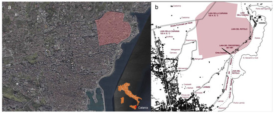
Figure 1. (a) Picanello neighborhood in the urban context of Catania; (b) The countryside area intended to the north-eastern urban development (our elaboration from [7]).
Even the Masterplan of 1934 could not start the construction of the neighborhood, due to the incompleteness of the administrative process covering just the zoning plan, then further updated, in 1952, when, finally, the municipal administration established the municipal delegations for decentralizing the utilities in the new suburbs. According to the Masterplan by Piccinato, in 1964, a Directional and Commercial Centre was supposed to be constructed in Picanello (Figure 2, zone “I” in fuchsia), after the preparation of a Detailed Plan, thus supporting the creation of a new urban pole.
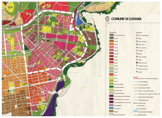
Figure 2. Picanello in the Piccinato Masterplan framework, 1964; the red area displays the prescription for a commercial and directional center (Source: Municipality of Catania, Italy, http://pcn.minambinente.it/viewer/, accessed on 15 January 2019).
The municipal territory of Catania is divided into 10 Municipal Areas (I Centro; II Ognina-Picanello-Stazione, III Borgo-Sanzio, IV Barriera-Canalicchio, V San Giovanni Galermo, VI Trappeto-Cibali, VII Monte Po-Nesima, VIII San Leone-Rapisardi, IX San Giorgio-Librino, X S. Giuseppe La Rena-Zia Lisa) established in 1995, then (2012) grouped in six Districts (Figure 3). A further subdivision concerns the 19 census areas (ACEs). Picanello is part of the II Municipal Area together with the neighborhood of Ognina and belongs to the Second District together with the IV Municipal Area (Barriere Canalicchio) and includes the whole ACE 12 and a small area of ACE 11.
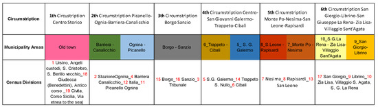
Figure 3. Articulation of the municipality of Catania in circumscriptions, municipal areas, census divisions (ACEs, census areas).
As for ACE 12, Picanello is the most populous municipal area of Catania (14,438 inhabitants; 17,980 inhabitants/sq.km) and one of the most densely built (Figure 4).
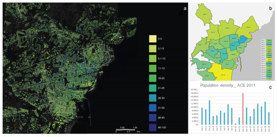
Figure 4. (a) Buildings floors map (source: National Geoportal http://www.pcn.minambiente.it/viewer/; (b) population density over all the urban ACEs; (c) comparison of the demographic density in the different ACEs: y-axis inhabitants/sq.km (Our elaboration on National Institute of Statistics).
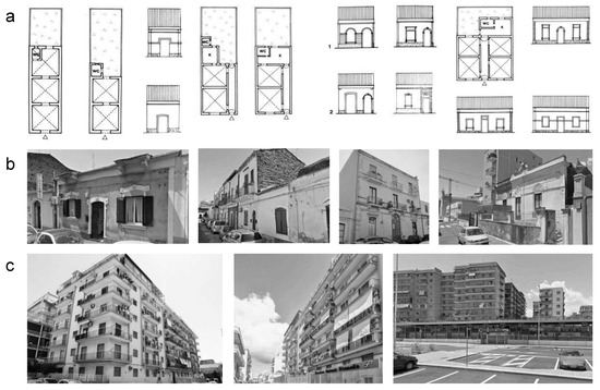
The urban-scape characterized by an urban fabric, including a wide range of building types, also due to the recent replacement of the original buildings by the contemporary ones and public facilities, sometimes strongly modifying the original settlement arrangement (Figure 5).
Many social and urban criticalities affect the neighborhood whose complexity and contradictions compensate to each other, thus revealing a significant degree of vitality, as well as outlining positive prospects and opportunities.
References
- United Nations: Sustainable Development Goals. Available online: https://www.un.org/sustainabledevelopment/sustainable-development-goals/ (accessed on 28 January 2020).
- United Nations Department of Economic and Social Affairs (UN-DESA). World Urbanization Prospects; United Nations Department of Economic and Social Affairs: New York, NY, USA, 2014.
- United Nations Department of Economic and Social Affairs (UN-DESA). World Population Prospects; Key Findings and Advance Tables; United Nations Department of Economic and Social Affairs: New York, NY, USA, 2015.
- Giuffrida, S. City as Hope. Valuation Science and the Ethics of Capital. Green Energy and Technology; Springer: Berlin/Heidelberg, Germany, 2018; pp. 469–485. ISSN 1865-3529.
- EC (European Commission). Social Protection Committee Indicators Sub-group EU Social Indicators—Europe 2020 Poverty and Social Exclusion Target. Available online: http://ec.europa.eu/social/main.jsp?catId=756&langId=en (accessed on 27 July 2017).
- National Institute of Statistics, 8milaCensus—ISTAT. Available online: www.ottomilacensus.istat.it (accessed on 13 May 2017).
- Pagello, E. Architettura minore a Catania all’inizio del secolo: Un caso di studio Picanello; University of Catania: Catania, Italy, 1990.