Your browser does not fully support modern features. Please upgrade for a smoother experience.
Please note this is an old version of this entry, which may differ significantly from the current revision.
The interactions between the geophysical processes and geodynamics of the lithosphere play a crucial role in the geologic structure of the Earth’s crust. The Bangui magnetic anomaly is a notable feature in the lithospheric structure of the Central African Republic (CAR) resulting from a complex tectonic evolution.
- programming
- geophysics
- GMT
- mapping
- Africa
- geology
1. Introduction
1.1. Background
The problem of feature matching in Earth studies can be described as matching the extent, direction and intensity of the geophysical and geologic processes, objects and phenomena visualised on the maps. A particular geophysical orgeologic feature is associated with a coordinate position in a cartographic domain identifying its location, and variables representing its appearance either by the points for discrete objects or by the fields for continuum processes. For analysis of correlation and links between diverse geologic and geophysical variables, matched feature points and continued fields represented on the maps should maintain similar regional appearance as well as relative spatial relationships with other processes, e.g., variation in topography or geoid and regional distribution of the geologic units. Analysis of correlation between geophysical and geological variables has extensive uses in integrated geophysical and seismic analysis [1], hydrological and engineering geological studies [2][3][4], geophysical anomalies [5], mineral exploration [6], or landslide hazard risk assessment in the areas with complex geology [7][8].
Each cartographic-matching method supports either a specific data format, e.g., such as ArcGIS shape files [9][10][11] or the tiled format for image processing in remote sensing software [12][13] or a limited set of converted and imported data formats from the multi-source data [14][15][16]. Scripting and programming methods also showed their effectiveness in matching tasks and coherence analysis when dealing with topographic and geophysical datasets since they optimise the workflow via smooth, automated and rapid approaches in data processing. For instance, scripts facilitate the modelling of geochemical–geophysical inversion to investigate the issues of dynamic topography [17], enable automated and optimised isolines approximation and mesh gradation in topographic data processing [18], or support detailed topographic analysis through 3D cross-sections [19][20].
2. Regional Geology
The geology of CAR is notable by the presence of the two prominent greenstone belts formed during the Archaean Eon as metamorphosed mafic volcanic sequences within the granite–gneiss volumes [21]. The greenstone belts are located to the north of Bouca in the West Zaire Precambrian Belt (Figure 1) as narrow subparallel bands of the extrusive igneous rocks (basalts and andesites) placed on a sialitic basement [22]. The first one is a 250-km long Bandas belt composed of volcanic and metasedimentary rocks [23] and the second is located in the west—a 150-km long Bogoin-Boali belt with anomalously high gold deposits [24]. They further include the tholeiitic basalts, dolerites from the Proterozoic dyke swarms and sills and andesites formed during crystallization of the basaltic magma [25].
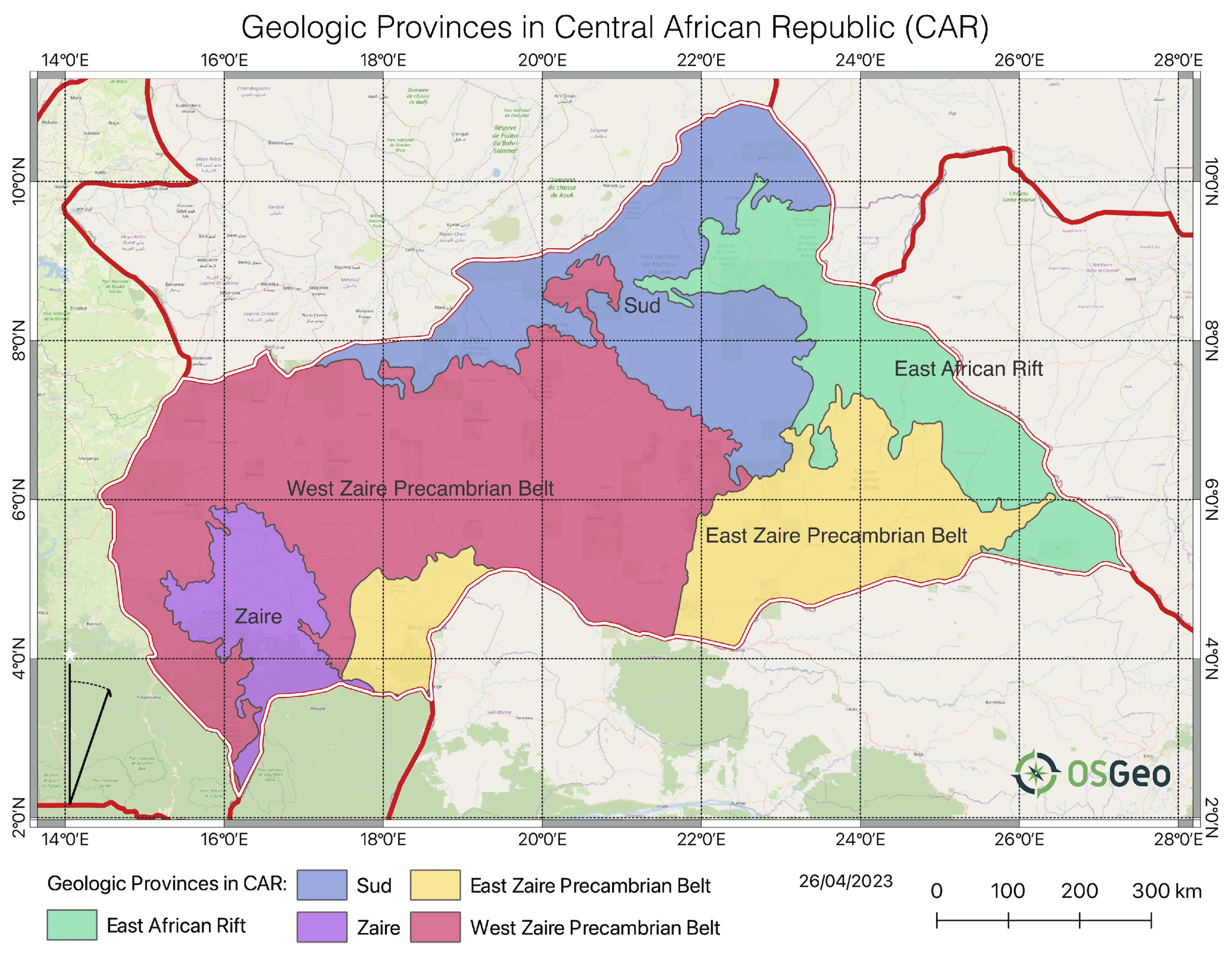
Figure 1. Geologic provinces in CAR. Data source: USGS. Background topographic map: OSGeo.
The geochemistry of the greenstone belts also includes the metamorphic minerals of the greenschist facies, pyroxenes and olivines [26]. The presence of back-arc tholeiites and arc-related greywackes argues for a compressive margin plate boundary for the greenstone belts indicating high tectonic activity in the marginal areas of the Congolese Craton [27]. Further, the arc-related ultramafic origin of the bulk rocks caused by complex tectonic activity in the past, is also proved by [28] who reported on the geochemistry and petrogenesis of ultramafic rocks in the Precambrian terrane of the northern CAR. They indicate that the presence of olivine and pyroxene, magnesio-hornblende and magnetite in the West Zaire Precambrian Belt (Figure 1) indicates intense Precambrian mafic magmatism processes in the past. The magnesian intrusive of Paleoproterozoic age is also found in the Tamkoro-Bossangoa Massif in the northwest intruded into a strike-slip shear zone. They are composed by gneisses with grained quartz diorites and biotite granites [29].
The deposits of the Bangui basin in the southern region of the CAR are dominated by the granodiorites which belong to the foreland of the Pan-African Oubanguides belt in the stratum deposited during the Proterozoic period of the Precambrian (pCm) [30]. The metamorphic rocks of the Bossangoa-Bossembélé area in the north of the country consist of the sedimentary and igneous units which are indicative of granulite facies conditions deposited on an old Paleoproterozoic continental crust [31][32]. The Precambrian carbonate platforms are widely distributed in CAR as the remaining evidence of the paleoenvironment. For instance, these include the carbonate deposits in the Ombella-M’poko Formation consisting of metamorphosed carbonate facies (calcite, dolomite and quartz) on top of the fluvioglacial sediments covered by siliciclastics [33].
Later examples of the palaeogeographic formations include the Carnot—a Mesozoic fluvio-lacustrine detrital formation located in the western part of the CAR and presented by clastic material formed before the end of the Cretaceous [34]. More details on alluvial deposits of Carnot sandstones are given in [35]. Active tectonic movements and volcanic eruptions during the Cretaceous resulted in distribution of the typical morphological bodies of the intrusives igneous rocks—dykes and sills [36].
Regional stratigraphy of the CAR is illustrated in Figure 2. The stratigraphic succession is presented by the oldest rocks from the Precambrian (Pc) and following Paleozoic (Pz) periods; the Mesozoic successions comprised of rocks from the Cretaceous (K) and Lower Cretaceous (Kl) periods; Cenozoic (QT) successions comprised of rocks from the Pleistocene (Qp), Holocene (Qe), Quaternary (Q) and Tertiary (T) periods. The Precambrian (pCm) metamorphic formation is most exposed with dominating quartzite-schistose and upper quartzite (Bangui and Nola) series. The granitic bodies and associated gneisses of Lower Proterozoic age of Precambrian period intruding the upper series were tectonized during the period of orogeny and form the basement in the south-central CAR [37]. The greenstone belt of pCm, covered by a series of conglomerates, is distributed on a granitized gneiss basement and includes volcanites and schists [38].
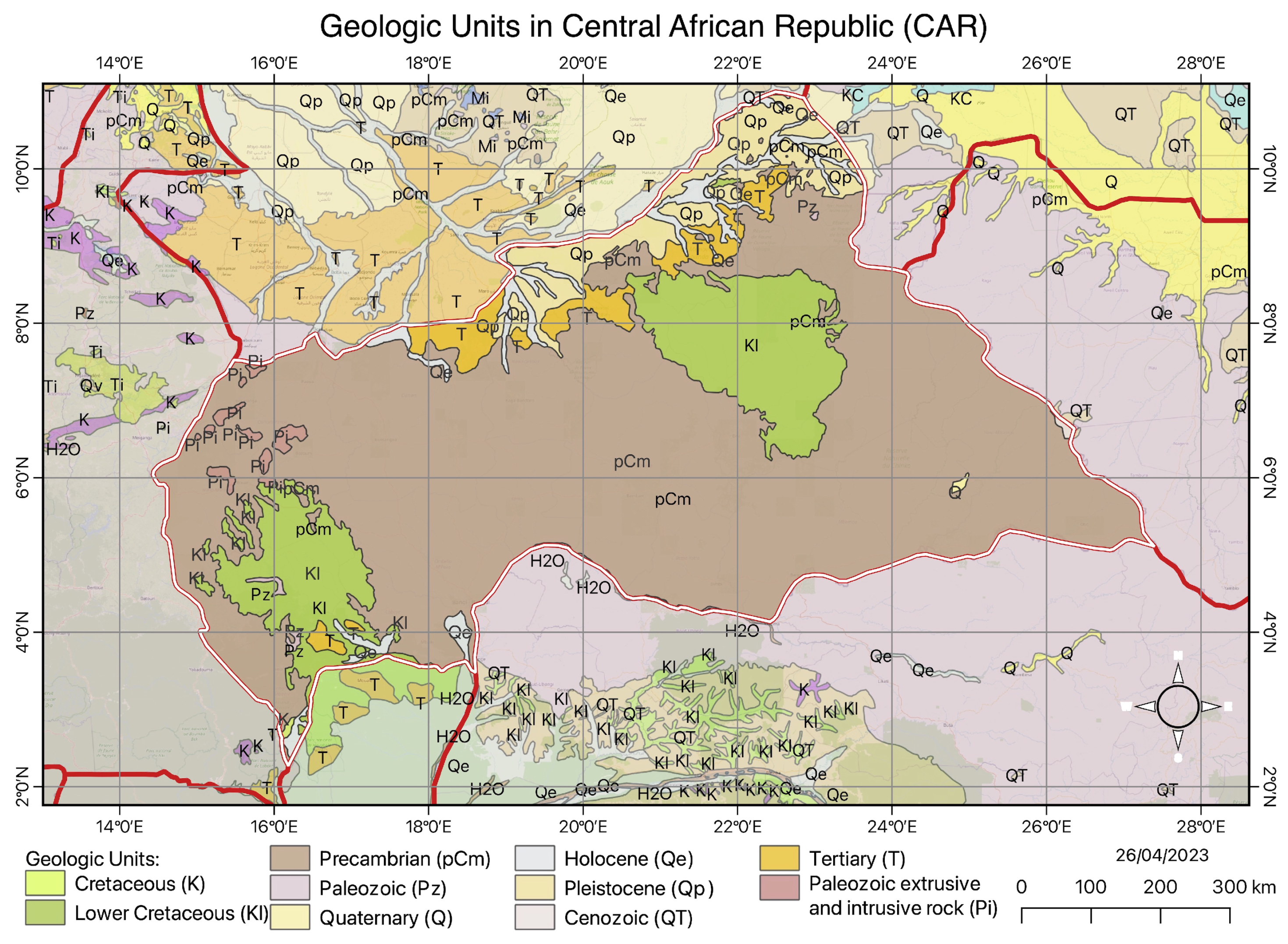
Figure 2. Geologic units and lithology in CAR. Data: USGS.
The southern region of CAR lithology continues along the northern border of the Congo Craton and is presented by the Lower Cretaceous (Kl) and Precambrian (pCm) successions (Figure 2). It is mostly composed of tholeitic basalts and gabbros of mafic and ultramafic rocks corresponding to the oceanic basalts and gabbros associated with iron-rich sediments and gneisses [39]. The Lower Cretaceous (Kl) succession, the second widely distributed in CAR, includes the fluvio-lacustrine deposits on the Central African shield [22]. Further, the interfluves of the dense fluvial network of rivers in CAR correspond to the series of plateaus with the presence of the polymorphic sandstones Tertiary (T) with the valleys composed of soft sandstone and argillites of Cretaceous (K) [40]. Further, the Bangui region is characterised by the Plutonic massifs distributed in the Ngouaka-Gbago area which include the gabbro, granodiorite, and granites that experienced the processes of the greenschist facies metamorphism [41].
The Paleozoic (Pz) period is notable for the emergence and geomorphic erosion in the earlier reliefs which resulted in the upper hilly surface of argillites in the northern regions of CAR [42]. The alluvium and colluvium from the Pleistocene (Qp) valleys with modern sediments of Holocene (Qe) form the basin of the modern Aouk river and its tributaries which create a natural border between CAR and Chad, Figure 2. The formations in the alluvial deposits also include notable intrusions of diamonds formed as a result of the ascent of the upper mantle and related magmatic processes during the geological history of CAR [43][44][45][46]. The geological development with favourable environmental setting of CAR situated in the equatorial, humid tropical and subequatorial climate resulted in its diverse natural resources. Rich mineral resources include gold-mining fields in the quartz veins in greenschist facies of the Paleoproterozoic formations [47] and alluvial diamonds [48]. The latter ones are distributed in the south-western and north-eastern regions in the Carnot and Mouka-Ouadda Sandstone formations [45][49].
The geomorphology of most of the CAR is represented by flat or hilly plateaus with dominated savannah [50] and dense ombrophile forest in the southern regions of the country [51] and the extreme northeast regions of CAR are a steppe. The northern region near the Bamingui and Bangoran rivers is presented by the Sahel-tropical forest [52]. The distribution of crops and related agriculture activities correspond to the different types of soil within various regions of the country which is in turn largely controlled by the regional setting of the geologic basement [53][54][55]. For instance, the organic matter in soil is controlled by the underlying geology as determining its chemical and physical nature. As a result, the extent and types of habitats and vegetation patterns vary accordingly [56][57]. Further, carbonated bed formations favour the development of karsts with typical relief and limestone soils in the southern regions of the Oubangui Basin [58].
This entry is adapted from the peer-reviewed paper 10.3390/min13050604
References
- Ndam Njikam, M.M.; Meying, A.; Zanga Amougou, A.; Ngon Ngon, G.F. Mapping transpressional and transtensional relay zones by coupling geological and geophysical field data: The case of the central Cameroon shear zone in the Mbere administrative division of the Adamawa region in Cameroon. J. Afr. Earth Sci. 2023, 199, 104816.
- Amponsah, T.Y.; Danuor, S.K.; Wemegah, D.D.; Forson, E.D. Groundwater potential characterisation over the Voltaian basin using geophysical, geological, hydrological and topographical datasets. J. Afr. Earth Sci. 2022, 192, 104558.
- Lemenkova, P.; Debeir, O. Recognizing the Wadi Fluvial Structure and Stream Network in the Qena Bend of the Nile River, Egypt, on Landsat 8–9 OLI Images. Information 2023, 14, 249.
- Lemenkova, P.; Debeir, O. Computing Vegetation Indices from the Satellite Images Using GRASS GIS Scripts for Monitoring Mangrove Forests in the Coastal Landscapes of Niger Delta, Nigeria. J. Mar. Sci. Eng. 2023, 11, 871.
- Matende, K.N.; Ranganai, R.T.; Mickus, K.L.; Lelièvre, P.G.; Mapeo, R.B.; Ramotoroko, C.D. Geophysical and geological investigation of the spatial and subsurface extent of the Segwagwa and Masoke igneous ring complexes in southeast Botswana: Geotectonic implications. J. Afr. Earth Sci. 2023, 197, 104766.
- Steuer, A.; Smirnova, M.; Becken, M.; Schiffler, M.; Günther, T.; Rochlitz, R.; Yogeshwar, P.; Mörbe, W.; Siemon, B.; Costabel, S.; et al. Comparison of novel semi-airborne electromagnetic data with multi-scale geophysical, petrophysical and geological data from Schleiz, Germany. J. Appl. Geophys. 2020, 182, 104172.
- Calamita, G.; Gallipoli, M.; Gueguen, E.; Sinisi, R.; Summa, V.; Vignola, L.; Stabile, T.; Bellanova, J.; Piscitelli, S.; Perrone, A. Integrated geophysical and geological surveys reveal new details of the large Montescaglioso (southern Italy) landslide of December 2013. Eng. Geol. 2023, 313, 106984.
- Di Maio, R.; De Paola, C.; Forte, G.; Piegari, E.; Pirone, M.; Santo, A.; Urciuoli, G. An integrated geological, geotechnical and geophysical approach to identify predisposing factors for flowslide occurrence. Eng. Geol. 2020, 267, 105473.
- Lar, U.A.; Bata, T.; Dibal, H.; Yusuf, S.N.; Lekmang, I.; Goyit, M.; Yenne, E. Potential petroleum prospects in the middle Benue trough, central Nigeria: Inferences from integrated applications of geological, geophysical and geochemical studies. Sci. Afr. 2023, 19, e01436.
- Ngene, T.; Mukhopadhyay, M.; Ampana, S. Reconnaissance investigation of geothermal resources in parts of the Middle Benue Trough, Nigeria using remote sensing and geophysical methods. Energy Geosci. 2022, 3, 360–371.
- Cheng, H.; Huang, Y.; Zhang, W.; Xu, Q. Physical process-based runout modeling and hazard assessment of catastrophic debris flow using SPH incorporated with ArcGIS: A case study of the Hongchun gully. CATENA 2022, 212, 106052.
- Konwea, C.I.; Evurani, D.E.; Ajayi, O. Assessment of groundwater potential of the Obafemi Awolowo University Estate, Southwestern Nigeria. Sci. Afr. 2023, 20, e01597.
- Al-Khersan, E.H.; Ali, S.M.; Al-Yasi, A.I. Environmental geophysical study for ideal locations of landfill within Iraqi Southern Desert. J. Appl. Geophys. 2022, 204, 104678.
- Saha, A.; Nath, A.; Dey, A.K. Multivariate geophysical index-based prediction of the compression index of fine-grained soil through nonlinear regression. J. Appl. Geophys. 2022, 204, 104706.
- Apeh, O.I.; Tenzer, R. Development of tailored gravity model based on global gravitational and topographic models and terrestrial gravity data for geophysical exploration of southern benue trough in southeast Nigeria. J. Appl. Geophys. 2022, 198, 104561.
- Shebl, A.; Abdelaziz, M.I.; Ghazala, H.; Araffa, S.A.S.; Abdellatif, M.; Csámer, Á. Multi-criteria ground water potentiality mapping utilizing remote sensing and geophysical data: A case study within Sinai Peninsula, Egypt. Egypt. J. Remote Sens. Space Sci. 2022, 25, 765–778.
- Jones, A.G.; Afonso, J.C.; Fullea, J. Geochemical and geophysical constrains on the dynamic topography of the Southern African Plateau. Geochem. Geophys. Geosyst. 2017, 18, 3556–3575.
- Gorman, G.; Piggott, M.; Wells, M.; Pain, C.; Allison, P. A systematic approach to unstructured mesh generation for ocean modelling using GMT and Terreno. Comput. Geosci. 2008, 34, 1721–1731.
- Sobh, M.; Ebbing, J.; Mansi, A.H.; Götze, H.J.; Emry, E.L.; Abdelsalam, M.G. The Lithospheric Structure of the Saharan Metacraton From 3-D Integrated Geophysical-Petrological Modeling. J. Geophys. Res. Solid Earth 2020, 125, e2019JB018747.
- Lemenkova, P.; Debeir, O. Quantitative Morphometric 3D Terrain Analysis of Japan Using Scripts of GMT and R. Land 2023, 12, 261.
- Poidevin, J.L. Les Ceintures de Roches Vertes de la Republique Centrafricaine (Bandas, Boufoyo, Bogoin, Mbomou). Contribution a la Connaissance du Precambrien du Nord du Craton du Congo. PhD Thesis, Université Clermont-Ferrand II, Clermont-Ferrand, France, 1991.
- Boulvert, Y. Esquisse de l’Histoire Géologique de la RCA; Institut Français de Recherche Scientifique pour le Développement en Coopération, ORSTOM: Bangui, Central African Republic, 1983.
- Poidevin, J.; Dostal, J.; Dupuy, C. Archaean greenstone belt from the Central African Republic (Equatorial Africa). Precambrian Res. 1981, 16, 157–170.
- Dostal, J.; Dupuy, C.; Poidevin, J.L. Geochemistry of Precambrian basaltic rocks from the Central African Republic (Equatorial Africa). Can. J. Earth Sci. 1985, 22, 653–662.
- Poidevin, J.L. Le protérozoïque supérieur de la République centrafricaine. Geol. Wetcnschappen 1985, 8, 1–75.
- Poidevin, J.L. Boninite-like rocks from the Palaeoproterozoic greenstone belt of Bogoin, Central African Republic: Geochemistry and petrogenesis. Precambrian Res. 1994, 68, 97–113.
- Cornacchia, M.; Giorgi, L.; Caruba, C.; Vivier, G. Existence d’une zone de suture sur la marge nord du craton congolais (secteur de Bangui, centre ouest de la République Centrafricaine). C. R. l’Acad. Sci. Sér. 2 Méc. Phys. Chim. Sci. l’Univ. Sci. Terre 1989, 308, 107–110.
- Tanko, E.; Danguene, P.; Tsoungui, P.; Ganno, S.; Wambo, J.D.T.; Tchoupe, B.G.T.; Nono, G.D.K.; Ngnotue, T.; Kankeu, B.; Biandja, J.; et al. Geochemistry and zircon U–Pb ages of the Paleoproterozoic ultramafic rocks of the Mbi Valley, Boali area, Central African Republic. Acta Geochim. 2022, 41, 515–535.
- Danguene, P.; Ngnotue, T.; Ganno, S.; Biandja, J.; Kankeu, B.; Nzenti, J. Paleoproterozoic Synkinematic Magnesian High-K Magmatism from the Tamkoro-Bossangoa Massif, along the Bossangoa-Bossembele Shear Zone in North-Western Central African Republic. J. Geosci. Geomat. 2014, 2, 151–164.
- Poidevin, J.; Pin, C. 2 Ga U-Pb zircon dating of Mbi granodiorite (Central African Republic) and its bearing on the chronology of the Proterozoic of Central Africa. J. Afr. Earth Sci. (1983) 1986, 5, 581–587.
- Tanko Njiosseu, E.; Danguene, P.E.; Ngnotue, T.; Ganno, S.; Nono, G.D.K.; Nlend, C.D.N.; Kankeu, B.; Biandja, J.; Nzenti, J.P. Petrology and geochronology of metamorphic rocks from the Bossangoa-Bossembélé area, Northern Central African Republic—Evidence for Palaeoproterozoic high-grade metamorphism in the North Equatorial Fold Belt. Arab. J. Geosci. 2021, 14, 1660.
- Gérard, G.; Gérard, J. Carte Géologique de Reconnaissance de l’A.E.F. Notice Explicative sur la Feuille Berbérati-Est—Scale: 500,000—Sheet Number/Numéro de Feuille/Bladnummer: NB 33 SE-E 33 Direction des Mines et de la Géologie de l’A.E.F-Brazaville. 1953. Available online: https://geocatalogue.africamuseum.be/geonetwork/srv/api/records/BE-RMCA-EARTHS-018894 (accessed on 7 April 2023).
- Toyama, R.; Ngos, S.; Sababa, E.; Tchouatcha, M.S.; Danguene Yedidya, E.P.; Préat, A.; Ndjigui, P.D. Paleoenvironment reconstruction of the Proterozoic carbonate platform, Ombella-M’poko formation (Central African Republic). J. Afr. Earth Sci. 2019, 156, 108–117.
- Censier, C.; Lang, J. Sedimentary processes in the Carnot Formation (Central African Republic) related to the palaeogeographic framework of Central Africa. Sediment. Geol. 1999, 127, 47–64.
- Censier, C. Characteristics of Mesozoic fluvio-lacustrine formations of the western Central African Republic (Carnot Sandstones) by means of mineralogical and exoscopic analyses of detrital material. J. Afr. Earth Sci. 1990, 10, 385–398.
- Loule, J.P.; Pospisil, L. Geophysical evidence of Cretaceous volcanics in Logone Birni Basin (Northern Cameroon), Central Africa, and consequences for the West and Central African Rift System. Tectonophysics 2013, 583, 88–100.
- Lavreau, J.; Poidevin, J.; Ledent, D.; Liegeois, J.; Weis, D. Contribution to the geochronology of the basement of the Central African Republic. J. Afr. Earth Sci. 1990, 11, 69–82.
- Cornacchia, M.; Giorgi, L. Discordances majeures et magmatismes des séries précambriennes de la région de Bogoin (Centre ouest de la République Centrafricaine). J. Afr. Earth Sci. 1989, 9, 221–226.
- Topien, R.M.; Moloto-A-Kenguemba, G.; Traore, M.; Rajendran, S.; Kouassi, B.R. Litho-structural mapping and structural evolution of the Bocaranga pluton, northwest Adamawa-Yadé domain, Central African Republic. J. Afr. Earth Sci. 2023, 198, 104793.
- Mestraud, J.L.; Bouvier, P.; Dongala, M.; Touveron, G. Carte Géologique de la Républiquc Centrafricaine à l’Échelle du 1:1,500,000; Bureau de Recherches Géologiques et Minières (BRGM): Paris, France, 1964.
- Vonto, D.C.; Tchakounte, N.J.; Gentry, F.C.; Zaguy-Guerembo, R.L.; Zame, P.Z.; Djanarthany, S.; Nkoumbou, C. Geology and geotechnical characteristics of the Gbago and Ngouaka plutonic rocks, North East of Bangui, Central Africa Republic. J. Afr. Earth Sci. 2020, 167, 103831.
- Boulvert, Y. Étude Géomorphologique de la République Centrafricaine Carte à 1/1,000,000 en Deux Feuilles Ouest et Est; ORSTOM Éditions: Paris, France, 1995; Volume 110.
- Censier, C.; Michel, J.; Lamouille, B. Rapport Final du Projet d’Appui au Secteur Artisanal du Diamant en République Centrafricaine (PASAD) ; Technical Report 655, République Centrafricaine Ministère de la Réforme Economique du Plan et de la Coopération Internationale; BRGM Service Minier National, Département de l’Exploration: Orleans, France, 1998.
- Censier, C.; Tourenq, J. Crystal forms and surface textures of alluvial diamonds from the Western Region of the Central African Republic. Miner. Depos. 1995, 30, 314–322.
- Malpeli, K.C.; Chirico, P.G. A sub-national scale geospatial analysis of diamond deposit lootability: The case of the Central African Republic. Extr. Ind. Soc. 2014, 1, 249–259.
- Berthoumieux, G.; Delany, F. Mission diamant dans l’Ouest-Oubangui. Bull. Serv. Mines Géol. 1957, 77–91.
- Kpeou, J.; Béziat, D.; Salvi, S.; Estrade, G.; Moloto-A-Kenguemba, G.; Debat, P. Gold mineralization related to Proterozoic cover in the Congo craton (Central African Republic): A consequence of Panafrican events. J. Afr. Earth Sci. 2020, 166, 103825.
- Chirico, P.G.; Barthélémy, F.; Ngbokoto, F.A. Les Ressources Potentielles en Diamants Alluviaux et l’Évaluation de la Capacité de Production en République Centrafricaine; Technical Report 2010-5043; U.S. Geological Survey: Reston, VA, USA, 2013; 23p.
- Chirico, P.G.; Barthélémy, F.; Ngbokoto, F.A. Alluvial Diamond Resource Potential and Production Capacity Assessment of the Central African Republic; Technical Report 2010-5043; U.S. Geological Survey: Reston, VA, USA, 2007.
- Nguimalet, C.R.; Orange, D.; Waterendji, J.P.; Yambele, A. Hydroclimatic Dynamics of Upstream Ubangi River at Mobaye, Central African Republic. In Congo Basin Hydrology, Climate, and Biogeochemistry; American Geophysical Union (AGU): Washington, DC, USA, 2022; Chapter 6; pp. 83–96.
- Suchel, J.B. L’exploitation forestière en République Centrafricaine. Cah. d’Outre-Mer 1968, 21, 324–330.
- Spinage, C.A. First steps in the ecology of the Bamingui-Bangoran National Park, Central African Republic. Afr. J. Ecol. 1988, 26, 73–88.
- Villien, F. L’agriculture dans la ville: L’exemple de Bangui. Cah. d’Outre-Mer 1988, 41, 283–302.
- Quantin, P. Les Sols de la République Centrafricaine; Technical Report 16; Mérn. Office de la Recherche Scientifique et Technique Outre-Mer (ORSTOM): Paris, France, 1965; 113p.
- Prioul, C. Les cultures maraîchères à Bangui. Cah. d’Outre-Mer 1969, 22, 191–202.
- Combeau, A.; Quantin, P. Observation sur Ies relations entre stabilité structurale et matiére organique dans quelques sols d’Afrique Centrale. Cah. Off. Rech. Sci. Tech. Outre-Mer (ORSTOM) Pédolog. 1964, 2, 3–11.
- Quantin, P. Reconnaissance Pédologique au Nord-Est de la République Centrafricaine (Birao); Technical Report Rapport de Terrain; Office de la Recherche Scientifique et Technique Outre-Mer (ORSTOM) Inédit: Paris, France, 1962; p. 38.
- Salomon, J.N.; Boulvert, Y. Sur l’existence de paléo-crypto karsts dans le bassin de l’Oubangui (République centrafricaine). Karstologia 1988, 11, 37–48.
This entry is offline, you can click here to edit this entry!