应急通信是指广泛运用各种通信资源支持救援所需的通信手段和方法,包括紧急救援,以及在自然或人为紧急情况下的必要通信。由于灾害的特点,有效利用有限的资源提供最佳的通信服务是一个关键问题。与传统通信网络不同,应急通信网络是一个复杂的网络,能够实施应急救援活动,为实现应急救援功能提供首要条件。其网络结构对救援效率有重大影响。在不同的紧急情况下,对应急通信的需求不同,使用的技术手段也不同。应急通信主要具有以下特点:时间和地点的不确定性;容量需求的不确定性;应急通信的及时性高;环境的复杂性;通信网络本身损坏程度的不确定性;以及信息的多样化。
- broadband-narrowband integration
- emergency communication network
- narrowband private network
- satellite network
- space-air-ground-sea integrated networks
1. Introduction
Before a disaster, the emergency communication network can combine the data obtained from different systems to provide a technical platform for early warning, and disaster reduction and prediction, so as to improve the ability to monitor, manage, and control accidents and disasters. After a disaster, the emergency communication network can quickly and reliably restore communication in the disaster area, assist users, be used to rescue workers, support disaster relief headquarters, and realize on-site personnel scheduling, on-site data transmission, and other functions, to promote emergency rescue work. This can provide valuable time and first-hand information for the rescue, so as to save more lives. With the frequent occurrence of natural disasters and the tightening of the international security situation, countries all over the world are strengthening and improving the construction of emergency communication systems and related technology research, and striving to deploy a more reliable and stable emergency communication network.
-
Ability to work during both a disaster situation and at times of normality.
-
Dynamic expansion of the network to provide more coverage.
-
准确传输灾害信息,提供综合服务。
-
具有高可靠性、高冗余、高安全性、高抗干扰能力。
2. 网络分类
-
根据传输介质,网络可分为有线通信网络和无线通信网络。
-
根据属性,网络可分为公网和专用网。
-
根据地理分类,网络可分为局域网 (LAN)、城域网 (MAN) 和广域网 (WAN)。
2.1. 卫星网络
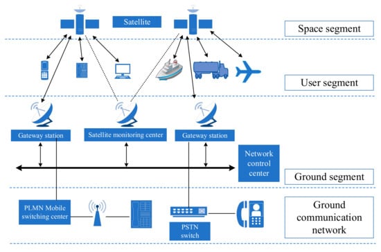
卫星通信技术是两个或多个地球站之间的通信方法,使用人造地球卫星作为中继站来转发无线电波。卫星通信系统通常按卫星轨道高度分类,可分为地球同步轨道(GEO)卫星、中地球轨道(MEO)卫星和低地球轨道(LEO)卫星。
卫星通信系统主要由空间、地面和用户段组成,如图1所示。航天段:以通信卫星为主体,用于接收和转发来自卫星通信地面站的信号,实现地球站之间或地球站与航天器之间的通信。地面部分:包括卫星转发器,网关站,卫星控制中心(SCC)和跟踪,遥测和指挥站(TT&C),实现用户之间的通信。用户细分:主要由各种终端用户设备组成,包括安装在汽车、船舶、飞机上的甚小型天线终端(VSAT)站、手持终端和移动终端,以及基于卫星通信的各种应用和服务。
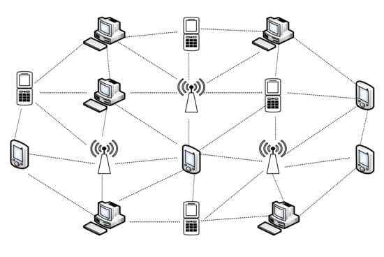
2.2. 自组网络
-
WMN是一种多跳网络,自动选择最佳路径,避免因障碍物导致通信故障,从而为不在视线范围内的用户提供服务传输能力。
-
WMN具有灵活多样的组网模式,支持动态拓扑组网,为高移动性需求的应用场景提供有效的组网能力,保证用户间连接质量,扩大网络覆盖范围。
-
WMN具有自组织、自愈、自平衡能力,网络可靠性强。
-
MANET is a distributed, multi-hop relay wireless broadband system without a center, and provides dynamic routing, strong damage resistance, and good scalability. Its network topology changes dynamically, and it internally uses its own routing protocol to complete wireless communication among nodes through wireless multi-hop forwarding.
-
MANET has the advantages of having a low deployment and maintenance cost, large coverage, high rate, strong network robustness and adaptability, and link self-sensing and self-healing. It can not only exist as an independent wireless self-organizing network, but also serve as an effective supplement and expansion of an existing heterogeneous network system.
-
MANET can be widely used in military communication private networks, public security private networks, emergency communication private networks, regional broadband private networks, and wireless monitoring private networks.
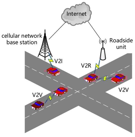
| Parameter | MANET | VANET | FANET | SANET |
|---|---|---|---|---|
| Number of nodes | high | high | low | low |
| Propagation model | on the ground | on the ground | in the air | on the sea |
| Topology | ad hoc and random | star with roadside infrastructure and ad hoc among vehicles | star and mesh (with base station, ad hoc among UAVs) | star and mesh (with base station, ad hoc among ships) |
| Topology change | dynamic, unpredictable, and low | average speed | fast | medium |
| Line of sight | not available for all cases | available in some cases | available in most cases | available in some cases |
| Power consumes | low | high | high for mini-UAV, small UAV not needed | high |
| Mobility | low | high | very high | medium |
| Mobility model | random | regular | regular under the condition | random |
| Main functionality | real-time communication | real-time communication | real-time communication | real-time communication |
| Computational power | limited | average | high | high |
| Density | low | high | very low | high |
| Localization | GPS | GPS, DGPS, AGPS | IMU, GPS, DGPS, AGPS | GPS, DGPS |
2.3. Cellular Networks
2.4. Wireless Private Networks
3. Summary of Network Development Status
3.1. 370M Narrowband Private Networks
3.2. Mobile Satellite Networks
3.3. Hybrid Networks
3.4. 5G Networks
4. Future Development Directions
With the rapid development of network technology and information technology, future emergency networks will develop in the direction of intelligence, integration, popularization, and low cost. This will mainly introduce network intelligence and integration, and lead to the development trend of space-air-ground-sea integration networks.
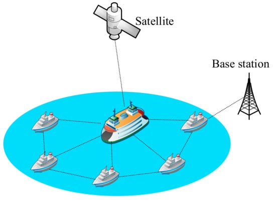
Due to limitations in the radio spectrum, service geographic coverage, and operating costs, 5G ground communication networks alone cannot provide high-quality and reliable services at any time and in any place. This is especially the case in remote areas such as oceans, forests, and deserts. In order to provide truly ubiquitous wireless communication services on a global scale, it is necessary to develop an integrated space-air-ground-sea network to achieve global connectivity. The rapid development of wireless, broadband, fusion, and three-dimensional network technology provides the construction foundation for the integration of the space-air-ground-sea network with information sharing, interconnection, and unified command. Integrated use of big data, cloud computing, AI, satellite communications, multimedia communications, mobile communications, and other advanced technologies, and integration of space-based, air-based, ground-based, and sea-based platforms, can be used to construct the space-air-ground-sea integrated emergency communication network architecture. This architecture can realize the overall emergency resource planning and collaborative services of multiple platforms. The network architecture is shown in Figure 7. The integrated space-air-ground-sea network is based on a ground network, extended by air-based and sea-based networks, and connected and supplemented by a space-based network; thus, it covers the natural space including space, the sky, the ground, and the ocean. The air-based network consists of satellites, which can be divided into GEO, MEO, and LEO satellites. The space-based network is composed of aerial platforms such as near-space airships, airplanes, UAVs, and hot-air balloons. The ground-based network is mainly composed of LANs and cellular mobile networks, including all wired and wireless network facilities on the ground. Currently, this mainly relies on 5G network technology. The sea-based network consists of coastal base stations, surface ships, buoys, etc.
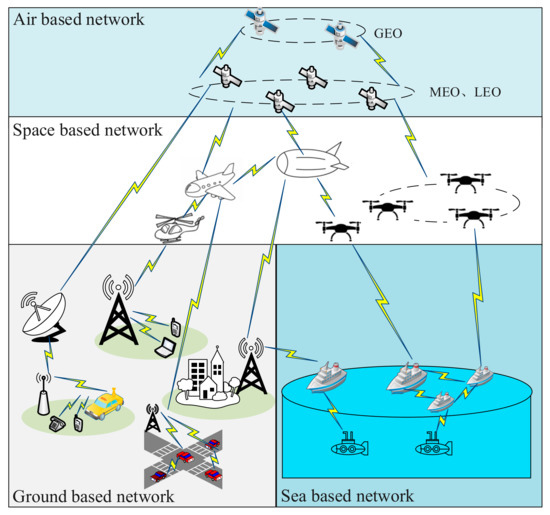
Figure 7. System topology of the space-air-ground-sea integrated emergency communication network.
This entry is adapted from the peer-reviewed paper 10.3390/rs15061595