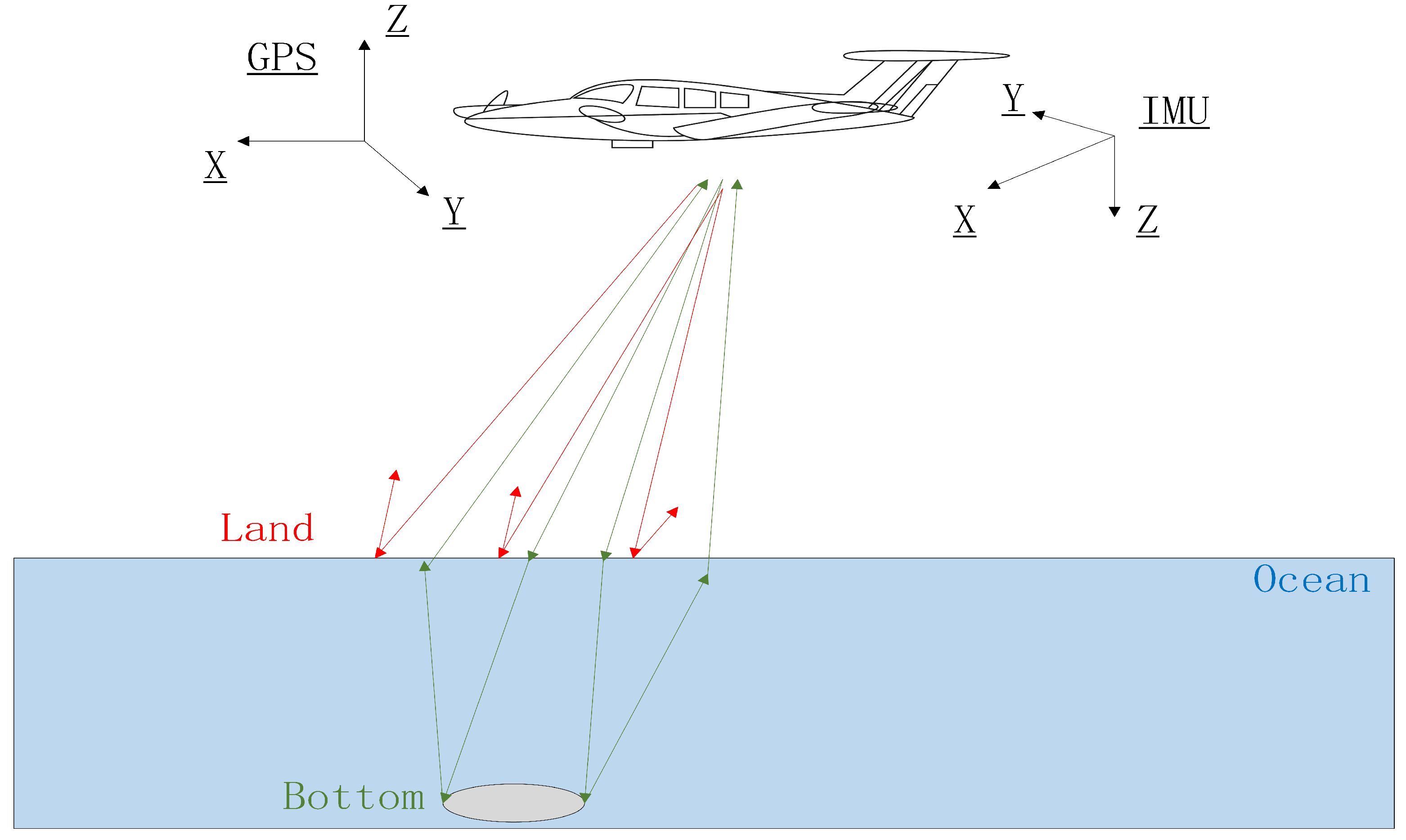
Since the shorelines are important geographical boundaries, monitoring shoreline change plays an important role in integrated coastal management. With the evolution of remote sensing technology, many studies have used optical images to measure and to extract shoreline. However, some factors limit the use of optical imaging on shoreline mapping. Considering that airborne LiDAR data can provide more accurate topographical information, they are used to map shorelines. There are two major types of airborne LiDAR systems that are commonly used in shoreline area surveys: the airborne laser topographic scanning system (ALT) and the airborne laser bathymetric scanning system (ALB).
- airborne LiDAR
- laser scanning system
- shoreline mapping
- shoreline extraction
1. Introduction
| Characteristic | Airborne LiDAR | Optical Satellite | |
|---|---|---|---|
| System | Sensor technology | Active | Passive |
| Performance | Spatial Resolution | Relatively High | Relatively Low |
| Dataset scale | National and regional | Global | |
| Vertical accuracy | High | Low | |
| Temporal resolution | Low | High | |
| Operation Restriction | Lighting conditions | Day and Night | Daytime |
| Cloud condition | No impact | Impact | |
| Terrain Condition | No impact | Impact | |
| Data | Type | Point cloud | Raster Imagery |
| Mapping Quality | Spatial information | Three-dimensional | Two-dimensional |
| Shoreline extraction | Directly extract from point cloud or Image-processing techniques | Visual interpretation or image-processing techniques | |
2. Airborne LiDAR Systems Development and Datasets Availability for Shoreline Mapping
2.1. Airborne Laser Topographic and Bathymetric Scanning System for Shoreline Measurement
| Year | Sensor | Laser Range | Pulse Repetition Frequency | Vertical Accuracy | Horizontal Accuracy | Operation Altitude | Related Studies |
|---|---|---|---|---|---|---|---|
| 1996 | ATM | 1064 nm | 10 kHz | 0.15 m | 0.8 m | Typically 400–800 m | Coastal mapping and monitoring [13][41][42], shoreline extraction [43][44] |
| 1998 | Optech ALTM 1210 | 1100 nm | Max 10 kHz | 0.15 m | 0.8 m | Up to 1.2 km | Shoreline mapping [40] |
| 1999 | Optech ALTM 1225 | 1024 nm | Max 25 kHz | 0.15 m | Up to 2 km | Coastal application [45] and shoreline extraction [46][47] | |
| 2000 | Optech ALTM 1233 | 1100 nm | Max 33 kHz | Coastal application [45], Shoreline changes and features extraction [32], Beach segmentation [48], Inland water boundary extraction [21] | |||
| 2002 | Optech ALTM 2050 | 1064 nm | Max 50 kHz | 0.15 m (1200 m AGL) | Up to 2 km | Shoreline mapping [49][50] | |
| 2003 | Optech ALTM 30/70 | 1064 nm | Max 70 kHz | 0.15 m (1200 m AGL) | 1/2000 × altitude (1σ) | Up to 3 km | Shoreline mapping [51], coastal erosion and accretion [52] |
| 2004 | Optech ALTM 3100 | 1064 nm | Max 100 kHz | 0.15 m (1200 m AGL) | 1/5500 × altitude (1σ) | Up to 3.5 km | Coastal mapping [53] and shoreline extraction [54][55] |
| 2008 | RIEGL Q680i-D | 1550 nm | Max 400 kHz | 0.02 m (1σ) (250 m AGL) |
Up to 1.6 km | Shoreline extraction [56][57] and volumetric changes of soft cliff coast [58] | |
| 2012 | Optech Pegasus HA500 | 1064 nm | Max 500 kHz | 0.05–0.2 m (1σ) | 1/7500 × altitude (1σ) | Up to 5 km | Shoreline extraction [59][60] |
| Year | Sensor | Laser Range | Pulse Repetition Frequency | Depth Accuracy | Vertical Accuracy | Horizontal Accuracy | Operation Altitude | Related Studies |
|---|---|---|---|---|---|---|---|---|
| 2001 | EAARL | 532 nm | 3–10 kHz | 5–10 cm | <1 m | Nominal 300 m | Shoreline mapping [49][65], coastal monitoring [66] | |
| 2003 | Optech SHOALS 1000T | 532 nm + 1064 nm | Max 10 kHz | 0.52+(0.013×depth)2−−−−−−−−−−−−−−−−−−√ m | 2.5 m (1σ) | 200–400 m | Seafloor mapping [67], shoreline mapping [49] | |
| 2006 | Optech SHOALS 3000T-H | 532 nm + 1064 nm | 20 kHz | 0.25 m (1σ) | 0.25 m (1σ) | 2 m (1σ) 1/500 × altitude (1σ) |
300–400 m | Coastal mapping [68] and shoreline extraction [69] |
| 2010 | Optech CZMIL | 532 nm + 1604 nm | 10 kHz (green), 70 kHz (infrared) | 0.32+(0.013×depth)2−−−−−−−−−−−−−−−−−−√ m, 2σ, 0–30 m | 0.15 m (2σ) | 1 m (2σ) | Nominal 400 m, up to 1 km | Coastal mapping and monitoring [15][27][70] |
| 2015 | Leica Chiroptera II | 515 nm + 1064 nm | 35 kHz (green), 500 kHz (infrared) | 0.15 m | 2 cm (1σ) | 0.20 m (1σ) (400 m AGL) |
400–600 m, up to 1.6 km | Coastal mapping [71] and shoreline monitoring [72]) |
| 2018 | Riegl VQ-880G | 532 nm + 1064 nm | Max 550 kHz | 0.32+(0.013×depth)2−−−−−−−−−−−−−−−−−−√ m | 10 cm | Max 800 m | Coastal mapping [73] |
2.2. Datasets Availability in Coastal Areas
| Country | Data Format | Spatial Resolution | Surveyed Year | Coverage | Additional Note | Reference |
|---|---|---|---|---|---|---|
| Australia | Airborne LiDAR-derived DTM | 5 m | 2001–2015 | 45,000 km2 | Cover Australia’s populated coastal zone; floodplain surveys within the Murray Darling Basin, and individual surveys of major and minor population centers. | https://www.ga.gov.au/ |
| Canada | Airborne LiDAR point clouds | 1–2 m | 2013–present | Partially covered eastern coastal area and Great Lakes area | Provincial-based nationwide project covering most major cities. | https://open.canada.ca/ |
| Japan | Airborne LiDAR point clouds | Just launched | 35,000 km of coastline | Map of the Sea Project launched in 2022 | https://www.jha.or.jp/en/jha/ (accessed on 8 December 2022) | |
| Scotland | Airborne LiDAR point clouds | 4 points/m 2 | 2011–2021 | More than 45,078 km2 in total area | 5 phases, covering the partial coastal area | https://remotesensingdata.gov.scot (accessed on 8 December 2022) |
| USA | Airborne LiDAR point clouds | 0.15–3 m | 1999–present | Fully covered inland USA coastal area and Great Lakes area, partially covered Alaska | Surveyed by the U.S. Army Corps of Engineers, NOAA, and U.S. Geological Survey | https://coast.noaa.gov/digitalcoast/data/jalbtcx.html (accessed on 8 December 2022) |
| New Zealand | Airborne LiDAR point clouds | 1 m | 2010–present | More than half coastal line | Still ongoing to collect the data | https://www.linz.govt.nz/products-services/data/types-linz-data/elevation-data/provincial-growth-fund-LiDAR-data-collection-now-progress (accessed on 8 December 2022) |
This entry is adapted from the peer-reviewed paper 10.3390/rs15010253
References
- Wu, T.; Hou, X. Review of research on coastaline changes. Acta Ecol. Sin. 2016, 36, 1170–1182.
- Toure, S.; Diop, O.; Kpalma, K.; Maiga, A. Shoreline detection using optical remote sensing: A review. ISPRS Int. J.-Geo-Inf. 2019, 8, 75.
- Crossland, C.J.; Baird, D.; Ducrotoy, J.P.; Lindeboom, H. The Coastal Zone—A Domain of Global Interactions. In Coastal Fluxes in the Anthropocene: The Land-Ocean Interactions in the Coastal Zone Project of the International Geosphere-Biosphere Programme; Global Change—The IGBP Series; Springer: Berlin/Heidelberg, Germany, 2005; book section Chapter 1; pp. 1–37.
- Boak, E.H.; Turner, I.L. Shoreline definition and detection: A review. J. Coast. Res. 2005, 21, 688–703.
- May, S.K.; Dolan, R.; Hayden, B.P. Erosion of the US shorelines. Eos Trans. Am. Geophys. Union 1983, 64, 521–523.
- Ghosh, M.K.; Kumar, L.; Roy, C. Monitoring the coastline change of Hatiya Island in Bangladesh using remote sensing techniques. ISPRS J. Photogramm. Remote Sens. 2015, 101, 137–144.
- Lee, I.C. Instantaneous shoreline mapping from worldview-2 satellite images by using shadow analysis and spectrum matching techniques. J. Mar. Sci. Technol. 2016, 24, 1204–1216.
- Alesheikh, A.A.; Ghorbanali, A.; Nouri, N. Coastline change detection using remote sensing. Int. J. Environ. Sci. Technol. 2007, 4, 61–66.
- Graham, D.; Sault, M.; Bailey, C.J. National ocean service shoreline—Past, present, and future. J. Coast. Res. 2003, 38, 14–32. Available online: http://www.jstor.org/stable/25736597 (accessed on 26 December 2022).
- Liu, X.; Jia, R.; Liu, Q.; Zhao, C.; Sun, H. Coastline extraction method based on convolutional neural networks—A case study of Jiaozhou Bay in Qingdao, China. IEEE Access 2019, 7, 180281–180291.
- Moore, L.J. Shoreline mapping techniques. J. Coast. Res. 2000, 16, 111–124.
- Ackermann, F. Airborne laser scanning: Present status and future expectations. ISPRS J. Photogramm. Remote Sens. 1999, 54, 64–67.
- Brock, J.C.; Wright, C.W.; Sallenger, A.H.; Krabill, W.B.; Swift, R.N. Basis and methods of NASA airborne topographic mapper lidar surveys for coastal studies. J. Coast. Res. 2002, 18, 1–13.
- García-Rubio, G.; Huntley, D.; Russell, P. Evaluating shoreline identification using optical satellite images. Mar. Geol. 2015, 359, 96–105.
- Kim, H.; Lee, S.B.; Min, K.S. Shoreline change analysis using airborne LiDAR bathymetry for coastal monitoring. J. Coast. Res. 2017, 79, 269–273.
- Liu, Y.; Wang, X.; Ling, F.; Xu, S.; Wang, C. Analysis of Coastline Extraction from Landsat-8 OLI Imagery. Water 2017, 9, 816.
- Mitri, G.; Nader, M.; Abou Dagher, M.; Gebrael, K. Investigating the performance of sentinel-2A and Landsat 8 imagery in mapping shoreline changes. J. Coast. Conserv. 2020, 24, 40.
- Morsy, S.; Shaker, A.; El-Rabbany, A.; Larocque, P.E. Airborne multispectral lidar data for land-cover classification and land/water mapping using different spectral indexes. ISPRS Ann. Photogramm. Remote Sens. Spat. Inf. Sci. 2016, III-3, 217–224.
- Obu, J.; Lantuit, H.; Grosse, G.; Günther, F.; Sachs, T.; Helm, V.; Fritz, M. Coastal erosion and mass wasting along the Canadian Beaufort Sea based on annual airborne LiDAR elevation data. Geomorphology 2017, 293, 331–346.
- Molander, C. Photogrammetry. In Digital Elevation Model Technologies and Applications: The DEM Users Manual; Maune, D.F., Bethesda, E., Eds.; ASPRS: Bethesda, MD, USA, 2001; pp. 121–142.
- Canaz, S.; Karsli, F.; Guneroglu, A.; Dihkan, M. Automatic boundary extraction of inland water bodies using LiDAR data. Ocean Coast. Manag. 2015, 118, 158–166.
- Lin, Y.C.; Cheng, Y.T.; Zhou, T.; Ravi, R.; Hasheminasab, S.; Flatt, J.; Troy, C.; Habib, A. Evaluation of UAV LiDAR for Mapping Coastal Environments. Remote Sens. 2019, 11, 2893.
- Shen, J.; Zhai, J.; Guo, H. Study on coastline extraction technology. Hydrogr. Surv. Charting 2009, 29, 74–77.
- Flood, M.; Gutelius, B. Commercial implications of topographic terrain mapping using scanning airborne laser radar. Photogramm. Eng. Remote Sens. 1997, 63, 327–366.
- Carter, J.; Schmid, K.; Waters, K.; Betzhold, L.; Hadley, B.; Mataosky, R.; Halleran, J. LiDAR 101: An introduction to Lidar Technology, Data, and Applications; Revised; NOAA Coastal Services Center: Charleston, SC, USA, 2012.
- Gens, R. Remote sensing of coastlines: Detection, extraction and monitoring. Int. J. Remote Sens. 2010, 31, 1819–1836.
- Sylvester, C.; Macon, C. Coastal remote sensing through sensor and data fusion with CZMIL. In Proceedings of the Oceans 2011 MTS/IEEE, Kona, HI, USA, 19–22 September 2011; pp. 1–5.
- Pe’eri, S.; Long, B. LIDAR Technology Applied in Coastal Studies and Management. J. Coast. Res. 2011, 2011, 1–5.
- Sesli, F.A.; Caniberk, M. Estimation of the coastline changes using LIDAR. Acta Montan. Slovaca 2015, 20, 225–233.
- Xu, S.; Ye, N.; Xu, S. A new method for shoreline extraction from airborne LiDAR point clouds. Remote Sens. Lett. 2019, 10, 496–505.
- Morsy, S.; Shaker, A.; El-Rabbany, A. Using multispectral airborne LiDAR data for land/water discrimination: A case study at Lake Ontario, Canada. Appl. Sci. 2018, 8, 349.
- Starek, M.J.; Vemula, R.K.; Slatton, K.C.; Shrestha, R.L.; Carter, W.E. Shoreline based feature extraction and optimal feature selection for segmenting airborne LiDAR intensity images. In Proceedings of the 2007 IEEE International Conference on Image Processing, San Antonio, TX, USA, 16 September–19 October 2007; IEEE: Piscataway, NJ, USA, 2007; Volume 4, pp. IV-369–IV-372.
- Shaker, A.; Yan, W.Y.; LaRocque, P.E. Automatic land-water classification using multispectral airborne LiDAR data for near-shore and river environments. ISPRS J. Photogramm. Remote Sens. 2019, 152, 94–108.
- Chen, X.; Lai, Z.; Li, W.; Cheng, X. Research on Some Key Technologies of Features Extraction from LIDAR Data in Coastal Zone. In Proceedings of the 2009 International Conference on Information Engineering and Computer Science, Wuhan, China, 19–20 December 2009; IEEE: Piscataway, NJ, USA, 2009; pp. 1–3.
- Yang, X. Remote Sensing and Geospatial Technologies for Coastal Ecosystem Assessment and Management; Springer Science & Business Media: Berlin/Heidelberg, Germany, 2009.
- Wehr, A.; Lohr, U. Airborne laser scanning—An introduction and overview. ISPRS J. Photogramm. Remote Rensing 1999, 54, 68–82.
- Adams, M.D. LiDAR design, use, and calibration concepts for correct environmental detection. IEEE Trans. Robot. Autom. 2000, 16, 753–761.
- Flood, M. LiDAR activities and research priorities in the commercial sector. Int. Arch. Photogramm. Remote Sens. Spat. Inf. Sci. 2001, 34, 3–7.
- Gisuser. Optech Announces Titan, the World’s First Multispectral Airborne Lidar Sensor. 2014. Available online: https://gisuser.com/2014/12/optech-announces-titan-the-worlds-first-multispectral-airborne-lidar-sensor/ (accessed on 23 December 2020).
- Robertson, W.; Whitman, D.; Zhang, K.; Leatherman, S.P. Mapping shoreline position using airborne laser altimetry. J. Coast. Res. 2004, 20, 884–892.
- Elaksher, A.F. Fusion of hyperspectral images and lidar-based dems for coastal mapping. Opt. Lasers Eng. 2008, 46, 493–498.
- Sallenger, A.H.; Krabill, W.B.; Swift, R.N.; Brock, J.; List, J.; Hansen, M.; Holman, R.A.; Manizade, S.; Sontag, J.; Meredith, A.; et al. Evaluation of airborne topographic lidar for quantifying beach changes. J. Coast. Res. 2003, 19, 125–133.
- Liu, H.; Sherman, D.; Gu, S. Automated extraction of shorelines from airborne light detection and ranging data and accuracy assessment based on Monte Carlo simulation. J. Coast. Res. 2007, 23, 1359–1369.
- Stockdon, H.F.; Sallenger, A.H.; List, J.H.; Holman, R.A. Estimation of shoreline position and change using airborne topographic lidar data. J. Coast. Res. 2002, 18, 502–513.
- Reineman, B.D.; Lenain, L.; Castel, D.; Melville, W.K. A portable airborne scanning lidar system for ocean and coastal applications. J. Atmos. Ocean. Technol. 2009, 26, 2626–2641.
- Paine, J.G.; Caudle, T.L.; Andrews, J.R. Shoreline and sand storage dynamics from annual airborne LIDAR surveys, Texas Gulf Coast. J. Coast. Res. 2017, 33, 487–506.
- Gibeaut, J.C.; White, W.A.; Hepner, T.; Gutiérrez, R.; Tremblay, T.A.; Smyth, R.; Andrews, J. Texas Shoreline Change Project: Gulf of Mexico Shoreline Change from the Brazos River to Pass Cavallo; Report; Texas Coastal Coordination Council: Austin, TX, USA, 2000.
- Starek, M.J.; Vemula, R.; Slatton, K.C. Probabilistic detection of morphologic indicators for beach segmentation with multitemporal LiDAR measurements. IEEE Trans. Geosci. Remote Sens. 2012, 50, 4759–4770.
- White, S. Utilization of LIDAR and NOAA’s vertical datum transformation tool (VDatum) for shoreline delineation. In Proceedings of the Oceans 2007, Aberdeen, UK, 19–22 June 2017; pp. 1–6.
- Woolard, J.W.; Aslaksen, M.; Longenecker, J.; Ryerson, A. Shoreline mapping from airborne lidar in Shilshole Bay, Washington. In Proceedings of the National Oceanic and Atmospheric Administration (NOAA) National Ocean Service (NOS), US Hydrographic Conference, Washington, DC, USA, 3 February 2003.
- Lee, I.S.; Park, H.J.; Lee, J.O.; Kim, Y.S. Delineating the natural features of a cadastral shoreline in South Korea using airborne laser scanning. IEEE J. Sel. Top. Appl. Earth Obs. Remote Sens. 2011, 4, 905–910.
- Song, D.S.; Kim, I.H.; Lee, H.S. Preliminary 3D Assessment of Coastal Erosion by Data Integration between Airborne LiDAR and DGPS Field Observations. J. Coast. Res. 2013, 1445–1450.
- Smeeckaert, J.; Mallet, C.; David, N.; Chehata, N.; Ferraz, A. Large-scale water classification of coastal areas using airborne topographic lidar data. In Proceedings of the 2013 IEEE International Geoscience and Remote Sensing Symposium—IGARSS, Melbourne, VIC, Australia, 21–26 July 2013; pp. 61–64.
- Limber, P.W.; List, J.H.; Warren, J.D.; Farris, A.S.; Weber, K.M. Using Topographic LIDAR Data to Delineate the North Carolina Shoreline. In Proceedings of the Coastal Sediments ’07, the Sixth International Symposium on Coastal Engineering and Science of Coastal Sediment Processes, New Orleans, LA, USA, 13–17 May 2007; pp. 1837–1850.
- White, S.A.; Parrish, C.E.; Calder, B.R.; Pe’eri, S.; Rzhanov, Y. LIDAR-derived national shoreline: Empirical and stochastic uncertainty analyses. J. Coast. Res. 2011, 62, 62–74.
- Yousef, A.; Iftekharuddin, K.M.; Karim, M.A. Shoreline extraction from light detection and ranging digital elevation model data and aerial images. Opt. Eng. 2014, 53, 011006.
- Yousef, A.H.; Iftekharuddin, K.; Karim, M. A new morphology algorithm for shoreline extraction from DEM data. In Proceedings of the Optical Pattern Recognition XXIV, Baltimore, MD, USA, 29–30 April 2013.
- Dudzińska-Nowak, J.; Wężyk, P. Volumetric changes of a soft cliff coast 2008–2012 based on DTM from airborne laser scanning (Wolin Island, southern Baltic Sea). J. Coast. Res. 2014, 70, 59–64.
- Incekara, A.H.; Seker, D.Z.; Bayram, B. Qualifying the LIDAR-derived intensity image as an infrared band in NDWI-based shoreline extraction. IEEE J. Sel. Top. Appl. Earth Obs. Remote Sens. 2018, 11, 5053–5062.
- Demir, N.; Bayram, B.; Şeker, D.Z.; Oy, S.; İnce, A.; Bozkurt, S. Advanced lake shoreline extraction approach by integration of SAR image and LIDAR data. Mar. Geod. 2019, 42, 166–185.
- Shan, J.; Toth, C.K. Topographic Laser Ranging and Scanning: Principles and Processing, 2nd ed.; CRC Press: Boca Raton, FL, USA; New York, NY, USA, 2018.
- Bakuła, K. Multispectral airborne laser scanning—A new trend in the development of LiDAR technology. Arch. Fotogram. 2015, 27, 25–44.
- García-Quijano, M.J.; Jensen, J.R.; Hodgson, M.E.; Hadley, B.C.; Gladden, J.B.; Lapine, L.A. Significance of altitude and posting density on Lidar-derived elevation accuracy on hazardous waste sites. Photogramm. Eng. Remote Sens. 2008, 74, 1137–1146.
- Pfennigbauer, M.; Ullrich, A. Multi-wavelength airborne laser scanning. In Proceedings of the International Lidar Mapping Forum, ILMF, New Orleans, LA, USA, 7–9 February 2011; pp. 1–10.
- White, S.A.; Wright, C.W.; Sellars, J.D.; Woolard, J.; Dunbar, A.; Le, B.; Aslaksen, M. Shoreline Delineation Using NASA’s Experimental Advanced Airborne Research Lidar (EAARL) and NOAA’s Vertical Datum Transformation Tool (VDatum); American Geophysical Union: Washington, DC, USA, 2006; Volume 2006, p. G53E–02.
- Houser, C.; Hapke, C.; Hamilton, S. Controls on coastal dune morphology, shoreline erosion and barrier island response to extreme storms. Geomorphology 2008, 100, 223–240.
- Wilson, J.C. Using airborne hydrographic LiDAR To support mapping of california’s waters. In Proceedings of the OCEANS 2008—MTS/IEEE Kobe Techno-Ocean, Kobe, Japan, 8–11 April 2008; pp. 1–8.
- Macon, C.L. USACE National Coastal Mapping Program and the next generation of data products. In Proceedings of the OCEANS 2009, Biloxi, MS, USA, 26–29 October 2009; pp. 1–7.
- Pe’eri, S.; Morgan, L.V.; Philpot, W.D.; Armstrong, A.A. Land-Water interface resolved from airborne LIDAR bathymetry (ALB) waveforms. J. Coast. Res. 2011, 62, 75–85.
- Wozencraft, J. Requirements for the Coastal Zone Mapping and Imaging Lidar (CZMIL). In SPIE Defense, Security, and Sensing; SPIE: Bellingham, WA, USA, 2010; Volume 7695.
- Webster, T. Results from 3 seasons of surveys in maritime Canada using the Leica Chiroptera II shallow water topo-bathymetric lidar sensor. In Proceedings of the Oceans 2017, Aberdeen, UK, 19–22 June 2017; pp. 1–4.
- Caudle, T.L.; Paine, J.G.; Andrews, J.R.; Saylam, K. Beach, Dune, and Nearshore analysis of southern Texas Gulf Coast Using xhiroptera LIDAR and imaging system. J. Coast. Res. 2019, 35, 251–268.
- Madore, B.; Imahori, G.; Kum, J.; White, S.; Worthem, A. NOAA’s use of remote sensing technology and the coastal mapping program. In Proceedings of the Oceans 2018 MTS/IEEE, Charleston, SC, USA, 22–25 October 2018; pp. 1–7.
- Lee, I.c.; Wu, B.; Li, R. Shoreline extraction from the integration of LiDAR point cloud data and aerial orthophotos using Mean Shift Segmentation. In Proceedings of the ASPRS 2009 Annual Conference, Baltimore, MD, USA, 9–13 March 2009; pp. 3033–3040.
- Zhang, L.; Ma, H.; Wu, J. Utilization of LiDAR and tidal gauge data for automatic extracting high and low tide lines. J. Remote Sens. 2012, 16, 405–416.
- Krabill, W.; Collins, J.; Link, L.; Swift, R.; Butler, M. Airborne laser topographic mapping results. Photogramm. Eng. Remote Sens. 1984, 50, 685–694.
- Stoker, J.; Parrish, J.; Gisclair, D.; Harding, D.; Haugerud, R.; Flood, M.; Andersen, H.E.; Schuckman, K.; Maune, D.; Rooney, P.; et al. Report of the First National Lidar Initiative Meeting; Report; US Department of the Interior, US Geological Survey: Reston, VA, USA, 2007.
- Guenther, G.C.; Cunningham, G.; LaRocque, P.E.; Reid, D.J. Meeting the accuracy challenge in airborne bathymetry. In Proceedings of the EARSeL-SIG-Workshop LiDAR, Dresden, Germany, 16–17 June 2000.
- Jerlov, N.G. Marine Optics; Elsevier Scientific Publishing Compan: Amsterdam, The Netherlands, 1976; Volume XIII, p. 231.
- Bonisteel, J.; Nayegandhi, A.; Wright, C.; Brock, J.C.; Nagle, D. Experimental Advanced Airborne Research Lidar (EAARL) Data Processing Manual; Report; U.S. Department of the Interior: Reston, VA, USA, 2009.