Your browser does not fully support modern features. Please upgrade for a smoother experience.
Please note this is an old version of this entry, which may differ significantly from the current revision.
Subjects:
Water Resources
A comprehensive assessment of flood risk requires a step-by-step analysis, starting with hydrometeorological examinations of runoff and flow, followed by an assessment of the vulnerability of those at risk.
- flooding
- forecasting
- modeling
- risk assessment
1. Comprehensive Flood Risk Assessment
It is often reported that flooding poses the greatest risk among natural hazards, and floods continue to plague prone regions, as well as to occur periodically in unexpected ways. The World Economic Forum’s Global Risks Report 2023 identified natural disasters and extreme weather as among the greatest risks facing the planet, and that with better early warning systems, significant savings in lives and damages are possible [1]. Such warning systems will require accurate and reliable data for decision support to inform tools for forecasting, planning and design, regulatory controls, and post-event studies. The assembly of required data for these applications to support flood risk assessment poses formidable challenges, especially for a comprehensive approach to determine risks of increasing flood impacts on people and places. Experience shows that collecting all data on one platform is especially challenging, whether they are used for forecasting or longer-range planning, design, and post-event studies. These studies will continue and require periodic renewal because changes in climate, land uses, and the socioeconomic status of vulnerable areas keep occurring.
For flood risk assessments to be comprehensive requires analysis at critical points where risk is increased or decreased, from weather conditions and initial precipitation to control points, and eventually to points of vulnerability where victims are affected by floods. Flood risk is sometimes taken to mean the chance of flooding, but a complete view includes the hazard, the potential damages, and the vulnerability of the people or places who can be harmed. The starting point is hydrometeorology, but a comprehensive approach to risk assessment involves more steps to identify where interventions will be most effective in reducing flood damages on an overall basis. Each step in the sequence of critical points requires analysis to determine either the likelihood of damaging events or the vulnerability of targets, as they are exposed to threats and protected by infrastructure and or nonstructural programs.
Although flood risk assessment tools have large bodies of knowledge, their effectiveness is challenged by increasing threats due to climate change, population growth, and shifting land uses, among other driving forces. Flood exposure persists in developed regions [1] and in low-income settings it increases due to lack of effective responses. Climate change is a special challenge because it can diminish the value of experience with past events for assessing risk [2]. It can be associated with dependent phenomena such as sea level rise, modified weather regimes that change snowmelt floods to more extreme rain-on-snow events, and to other hydrologic changes such as more extreme rainfall. Shifting land uses and geomorphological forms also pose challenges from forecasting to planning. Although flood risk reduction strategies have shifted from structural to integrated non-structural measures, risk factors must still be assessed from initial storm events through the chains of causes and effects. The goal of this paper is to develop a comprehensive view of these causes and effects, beginning with hydrometeorology and extending through hydrological phenomena to eventual economic, social, and environmental impacts. By taking such a comprehensive view, an overall picture of the state of the practice of flood risk assessment can be presented so that opportunities for improvement are evident.
The core of flood risk assessment toolsets is in the water sciences arena, which has an extensive knowledge base. Its concepts, challenges, and future research directions were reviewed in a recent state-of-the-art paper with some 250 references about advances in flood science, including risk management [3]. These many facets of flood knowledge require involvement of multiple disciplines, including climate scientists, engineers, hydrologists and other geoscientists, statisticians, geographers, economists, behavioral scientists, and lawyers. These contributions were reviewed in another comprehensive paper that reported a bibliometric analysis of the evolution and prospects of flood risk assessment [4].
2. Flood Risk Locations and Scenarios
Flood threats cascade through the water cycle with many interrelationships, including among atmospheric conditions, precipitation, runoff, flow or surge, and exposure of victims. The locations where negative consequences may occur include local urban areas, river basins, and coastal zones. Risk is also affected by performance of conveyance infrastructure for stormwater and stream systems, as well as barriers provided by dams, levees, and surge protection barriers. The effectiveness of management programs such as flood forecasting, warning, and flood insurance also affects risk, and the vulnerability of victims and places affects it as well. For example, elderly or immobilized people will normally be the most vulnerable and subject to multiple health hazards. Vulnerability of places depends on building stock and protections such as flood proofing. Flood forecasting is especially important because its accuracy and timeliness are directly related to the time and opportunities that victims have available to avoid damages [5].
Although it is generally thought that flood risk is increasing, the dimensions of search increases are not well defined. For example, climate change may create more intense rainfall but not necessarily increase annual peak floods maximums. Moreso, the extent to which disasters occur will be affected by adaption measures that may mitigate negative consequences. For example, in a study of flood exposure in 37 European countries since 1870, the authors found increases in areas inundated and numbers of persons affected, but there were also decreases in fatalities and declines in annual financial losses in recent years. The authors suspected that frequent flooding was underreported, which may have biased the results [6]. It seems apparent that declines in fatalities and financial losses will follow patterns of economic development where more affluent areas are able to protect people and property better than in the past. Furthermore, financial losses in lower income areas will show lower levels than in the more affluent areas for the simple reason that property values are lower.
The points where risk assessments are needed can be identified by location with reference to exposure to different types of floods. As shown in Figure 1, the different types of floods occur in riverine and coastal locations, as well as in cities with stormwater management issues can be grouped as riverine floods, coastal floods, and urban floods, respectively, with subcategories such as flash floods and minor and major stormwater events, among others. Additionally, compound events such as coastal and riverine floods together can occur. The figure illustrates rainfall over the watershed that will affect the riverine and urban locations. Snowmelt is a major flood driver in some scenarios as well. The storm surge will be determined by wind conditions, which often occur in conjunction with storms, such as tropical storms and hurricanes.
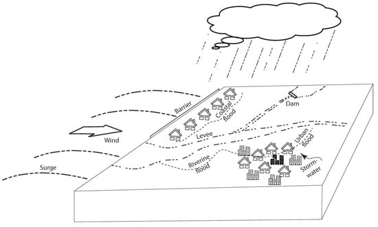
Figure 1. Reference diagram showing locations of riverine and coastal flood risks.
The sequence of risk assessment tools required in a comprehensive approach from weather conditions and initial precipitation to points of vulnerability where victims are affected by floods is illustrated by Figure 2. At the beginning, atmospheric circulation models, satellite data, and downscaling methods support numerical weather prediction and provide data to support runoff modeling. Precipitation models using atmospheric data, along with historic statistics, provide data on extreme rainfall that leads to runoff, which can impact local flood victims in urban areas or other victims through stream flooding. Other hydrologic data such as temperature and snow conditions must be considered to determine impacts of snowmelt on flooding. Runoff models, and feed information to hydraulic models, which indicate flow velocities and depths of water at various points along stream systems. Infrastructure systems and control structures such as dams and levees may be provided to mitigate flood damages, and they can also be at risk of failures that create dam break or levee breach flooding. Non-structural measures such as the use of flood mapping, land use management, and flood insurance are also intended to mitigate effects of flooding. The extent of potential consequences will depend on the vulnerabilities of people and places, as well as the effectiveness of the barriers. Coastal flooding risks are determined by similar variables, beginning with wind, surge hydraulics, vulnerability, and barriers. Each of the tools along this sequence has its own research base and literature, often with different researchers working on them.
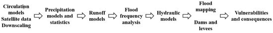
Figure 2. Sequence of data and analysis for comprehensive flood risk assessment.
The scenarios of flood risk assessment where these tools are used occur at small, medium, and large scales, and the analyses require somewhat different approaches [7]. At small scales, the usual situations involve urban stormwater, small watersheds, or site-based dam or levee safety. The medium scale involves river or coastal floods, which are also evident at large scales, such as the scenario where regional flood policies are to be determined. At all three scales, flood risk assessments are used for flood forecasting, as well as planning, design, and post-flood forensic analyses of causes. These assessments can address degrees of flood risk from the nuisance level up through disastrous events.
3. Hydrometeorology and Flood Risk
Hydrometeorological data and models for flood risk assessment begin with numerical weather prediction, which provides information for purposes such as flood forecasting and warning systems. With satellites providing remotely sensed data and advances in simulation modeling, the data and predictions continue to improve, and people are accustomed to reliable overall weather forecasts. Numerical weather models solve equations of the physical laws of atmospheric dynamics. The larger the scale and need to incorporate variability of spatial extent, time period, and modeling of specific phenomena, the more the computational power needed, and supercomputers serve weather service centers to provide forecasts at increasingly smaller scales as computational power increases. Forecasts are needed for small-to-large geographic scales and from short-to-long timescales. The smaller areas and shorter time spans pose the most challenges, but they are very important in providing time for potential victims to prepare [8].
After flood risk assessments draw precipitation data from numerical weather prediction studies, they can inform integrated modeling studies where climate predictions and statistical data are forcing functions for hydrologic runoff and streamflow models used to inform forecasting, planning and design, or forensic studies of flood disasters. In the U.S., the focus of integrated platforms is in programs of the Advanced Hydrological Prediction Service (AHPS), which is a recent development of the National Weather Service [9]. The AHPS is a platform to organize a suite of forecast products to display the magnitude of floods at different time scales. Most water-level data in the AHPS is from the gages of the United States Geological Survey (USGS), with additional information as available also used. The USGS has operated the system of stream gages for more than 100 years and is the main source of flood data in the nation. The data are organized and delivered to Weather Forecast Offices and River Forecast Centers, which run hydrologic models to create displays on AHPS web pages for used by different parties.
Although forecasting systems such as the AHPS are established and operational, research and development continue to improve them with next-generation global models such as the Model Prediction Across Scales (MPAS) system to enable transition from global to regional scales for downscaling to inform flood forecasts more effectively [10]. MPAS links atmospheric, oceanic, and land data for climate and weather studies [h] and can be used with the Weather Research and Forecasting (WRF) Model for numerical weather prediction. The WRF model links data and a computational software for applications across scales. It has a large user community and is used for real-time forecasting [11].
As numerical weather prediction methods and tools improve, they will help flood forecasters and provide spinoff benefits for planning, design, and forensic analysis. The state of the practice depends on the effectiveness of the scientists and system developers to incorporate research findings. In the case of research on general circulation models, an extensive body of literature explains advances in the global climate models and downscaling for use at appropriate locations. Although research advances continue, challenges occur when spatial scales of the models are not as fine as users require and when model outputs may be biased by observational data. The challenges for small areas and short time durations provide a major direction for research.
This entry is adapted from the peer-reviewed paper 10.3390/hydrology10020046
References
- Mishra, Ashok, Mukherjee, Sourav, Merz, Bruno, Singh, Vijay P., Wright, Daniel B., Villarini, Gabriele, Paul, Subir, Kumar, D. Nagesh, Khedun, C. Prakash, Niyogi, Dev, Schumann, Guy, Stedinger, Jery R.; An Overview of Flood Concepts, Challenges, and Future Directions.. Journal of hydrologic engineering 2022, 27 (6) , Online, https://doi.org/10.1061/(ASCE)HE.1943-5584.0002164.
- Mishra, Ashok, Mukherjee, Sourav, Merz, Bruno, Singh, Vijay P., Wright, Daniel B., Villarini, Gabriele, Paul, Subir, Kumar, D. Nagesh, Khedun, C. Prakash, Niyogi, Dev, Schumann, Guy, Stedinger, Jery R.; An Overview of Flood Concepts, Challenges, and Future Directions.. Journal of hydrologic engineering 2022, 27 (6) , 1, https://doi.org/10.1061/(ASCE)HE.1943-5584.0002164.
- Mishra, Ashok, Mukherjee, Sourav, Merz, Bruno, Singh, Vijay P., Wright, Daniel B., Villarini, Gabriele, Paul, Subir, Kumar, D. Nagesh, Khedun, C. Prakash, Niyogi, Dev, Schumann, Guy, Stedinger, Jery R.; An Overview of Flood Concepts, Challenges, and Future Directions.. Journal of hydrologic engineering 2022, 27 (6) , 1-10, https://doi.org/10.1061/(ASCE)HE.1943-5584.0002164.
- Díez-Herrero, Andrés, and Julio Garrote.; Flood Risk Analysis and Assessment, Applications and Uncertainties: A Bibliometric Review. . Water 2020, 12(7), 2050, https://doi.org/10.3390/w12072050. .
- Adams, T. E. III, and T. C. Pagano. . Flood forecasting: A global perspective. ; Academic Press: Cambridge, MA, 2016; pp. 1.
- Paprotny, D., A. Sebastian, O. Morales-Nápoles, and S. N. Jonkman. ” Nat. Commun. 9 (1): 1–12. https://doi.org/10.1038/s41467-018-04253-1; Trends in flood losses in Europe over the past 150 years.. Nature Communications 2018, 3. Paprotny, D., A. Sebastian, O. Morales-Nápoles, and S. N. Jonkman. 2018. “Trends in flood losses in Europe over the past 150 years.” Nat. Commun. 9 (1): 1–12. https://doi.org/10.1038/s41467-018-04253-1, 1-12, .
- De Moel, H., B. Jongman, H. Kreibich, B. Merz, E. Penning-Rowsell, and P. J. Ward.; Flood risk assessments at different spatial scales.. Global Change 2015, 20 (6), 865–890. , https://doi.org/10.1007/s11027-015-9654-z..
- Henonin, J., B. Russo, O. Mark, and P. Gourbesville; Real-time urban flood forecasting and modelling—A state of the art.. Journal of Hydroinformatics 2013, 15(3), 717-736, https://doi.org/10.2166/hydro.2013.132.
- Advanced Hydrological Prediction Service. . National Weather Service. Retrieved 2023-2-14
- Model for Prediction Across Scales (MPAS). . NCAR Mesoscale and Microscale Meteorology Laboratory. . Retrieved 2023-2-14
- Weather Research & Forecasting Model (WRF). . NCAR Mesoscale and Microscale Meteorology Laboratory. . Retrieved 2023-2-14
This entry is offline, you can click here to edit this entry!