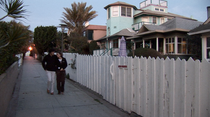
New Pedestrianism (NP) is a more pedestrian and ecology-oriented variation of New Urbanism in urban planning theory, founded in 1999 by Michael E. Arth, an American artist, urban/home/landscape designer, futurist, and author. NP addresses the problems associated with New Urbanism and is an attempt to solve various social, health, energy, economic, aesthetic, and environmental problems, with special focus on reducing the role of the automobile.A neighborhood or new town utilizing NP is called a Pedestrian Village. Pedestrian Villages can range from being nearly car-free to having automobile access behind nearly every house and business, but pedestrian lanes are always in front. To a large extent New Urbanism is a revival of traditional street patterns and urban design. New Pedestrianism also respects traditional town design, but seeks to further reduce the negative impact of the automobile, the use of which has increased dramatically since WWII. By eliminating the front street and replacing it with a tree-lined pedestrian lane, emphasis is placed on low-impact alternative travel such as walking and cycling. Pedestrian lanes are usually 12 to 15 feet (5 m) wide, with one smooth side for rolling conveyances such as bicycles, Segways, and skates and the other, narrower, textured side for pedestrians and wheelchairs. Eliminating the automobile street from the front allows for intimate scale plazas, fountains, pocket parks, as well as an unspoiled connection to natural features such as lakes, streams, and forests that may border or be included in a Pedestrian Village. A vast public realm is created that is free from the sight, smell, and sound of automobiles, yet automobiles are still served on a separate network. New Pedestrianism has been proposed for Kisima Kaya, a new town in Kenya, for Tiger Bay Village, FL as a solution to the homeless problem, and for new towns and neighborhoods that can be built anywhere whether as rehabilitation of existing neighborhoods, infill, edge-of-town neighborhoods, or new towns.
- urban planning
- pedestrianism
- cycling
1. The Automobile
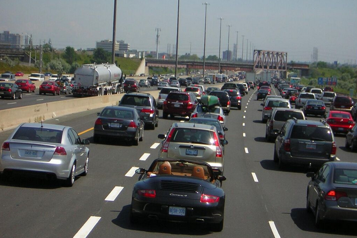
To a large extent, NP is a reaction to the way in which the automobile has affected the environment and reshaped the cities. Arth writes: “Our quality of life is dependent on achieving a spectrum of physical and psychological needs in a clean, safe, and beautiful environment that can only be accomplished with highly integrated urban design and planning. As long as vehicles, roads, parking lots, garages, and automobile-related businesses cover a significant portion of the landscape and determine the design of nearly everything else, most American cities will continue to be dysfunctional and degraded slumscapes, choked with traffic.”[1]

Over six million motor vehicle related accidents result in almost three million injuries, and over 42,000 deaths each year in the United States alone. Worldwide, approximately half a million deaths occur each year from motor vehicle accidents.[2]
Over-reliance on the automobile, coupled with the lack of a pedestrian-friendly environment, has contributed to two-thirds of adult Americans being overweight or obese.[3] Americans spend about $33 billion a year trying to lose weight. Degradation of the urban and rural landscape caused by sprawl also has wide-ranging negative effects on the environment and contributes to high maintenance costs to the infrastructure.[4]
Most Americans spend as much of their income on transportation as on housing, with residents of more automobile-dependent cities spending as much as three times as much of their Gross Regional Product (GRP). People in Houston, Atlanta, Dallas-Ft.Worth spend about 23% of their GRP on transportation compared to 9% in Honolulu, New York City, and Baltimore, and 7% in Toronto. These statistics are from the late 90’s before the huge runup in oil prices, and do not include some of the hidden costs of oil consumption.[5]
2. Energy
New Pedestrianism, in its ideal form, reduces the need for oil and other limited energy sources by reducing consumption and utilizing renewable energy. It is anticipated, especially as the cost of photovoltaic cells drops, that individual homes would be equipped with solar panels and solar water heaters, and that solar parks would harvest energy for the whole community. Reducing energy needs and moving away from oil dependency would presumably address health, social, economic, and environmental problems.[1]
3. Aesthetics
New Pedestrianism replaces front streets with tree-lined pedestrian lanes that form a linear park system that directly connects all homes and businesses to each other, as well as to parks, greenbelts, plazas, courtyards, water features, schools, recreation, and other amenities. This presumably raises the value of all property because the public and private properties are no longer devalued by the appearance and danger of excessive automobile dependency. A separate, tree-lined, street grid for cars also exists, but it is always relegated to the rear, and the pedestrian/bike grid as the primary transportation network ensures that unsightly, noisome, and often noisy traffic is vastly reduced on the rear streets. In Pedestrian Villages, density increases because buildings can be built close to quiet, car-free lanes without the need for huge setbacks that are typical in suburban sprawl. This, in turn, places more emphasis on building design, peaceful and intimate public spaces, and aesthetics that is scaled for pedestrians.[1]
4. History
Like New Urbanism, New Pedestrianism has its roots in compact, mixed-use neighborhoods common in the United States (and elsewhere) during and prior to the first quarter of the 20th century. New Pedestrianism borrows and then expands upon earlier experiments in urban design that focused on separating pedestrians from vehicular traffic.

In a few beachside communities in Southern California, including Venice, California, "walk streets" were constructed around 1905 in a few blocks near the beach. Houses faced pedestrian lanes that ranged between 3 and 10 feet wide. Narrow alleys in the rear handled cars and parking. The canals in Venice, California, built during the same period, also had both sidewalks and canals in front of the houses.[1]
Urban planners Ebenezer Howard and Sir Patrick Geddes were an earlier influence on the design of Radburn, New Jersey, built at the dawn of the automobile age in 1929. Radburn had pedestrian lanes in front and vehicular access at the rear on cul-de-sacs that protruded into large multi-use blocks. A study done in 1970 by John Lansing of the University of Michigan showed that 47% of its residents did their grocery shopping on foot, compared to 8% for a conventional subdivision nearby. He also determined that, overall, Radburn residents drove far less than in any other areas he studied. The Radburn plan has been copied in various forms in Sweden, England, Japan, New Zealand, and Australia.[6]
The San Antonio River Walk, also known as "Paseo del Rio," was initiated in 1929. In this case, the San Antonio River underwent flood control measures and was turned into a peaceful canal lined on both sides with lively pedestrian promenades, plazas, sidewalk cafes, restaurants, clubs, shops, hotels, and other attractions that are completely separate from any vehicles. The promenades pass underneath the roads since Paseo del Rio is one level below the street and vehicular access to buildings is one story above the river.
Village Homes in Davis, California was founded in 1975 by Michael and Judy Corbett. The 70-acre (280,000 m2) subdivision has 225 homes and 20 apartments. Solar design and solar panels are utilized for heating. The homes have walkways passing through an extensive greenbelt system on one side of the houses with automobile access on the other side.[7]
Some streets in the New Urbanist development of Rosemary Beach, Florida also have boardwalks in front of some of the homes.
In 2005 New Pedestrianism was offered by Arth as part of the solution to the rebuilding of New Orleans.[8][9]
5. Films and Books about New Pedestrianism
New Urban Cowboy, produced in 2008, is a feature-length documentary that tells the story of Arth's struggle to retrofit a crack slum into a Pedestrian Village while also explaining the philosophy of New Pedestrianism.[10]
Democracy and the Common Wealth: Breaking the Stranglehold of the Special Interests, gives a comprehensive assessment of society and how New Pedestrianism fits into the overall scheme of things. There are also many illustrations and photographs, and a section called "Anatomy of a Pedestrian Village."[11][12]
6. Examples
These are examples of New Pedestrianism-style pedestrian villages that represent the various types:[1]
- Venice, California - Walking streets with and without canals, and a car-free promenade, circa 1910.
- San Antonio River Walk, Texas - Car-free promenade, 1920s.
- Louvain-la-Neuve, Belgium - Pedestrian university town with parking hidden below, 1969.
- Downtown DeLand, Florida, USA - (Historic Garden District)- Infill retrofit of existing neighborhood, 2001-2007.
- Tiger Bay Village, Florida, USA - Proposed, nearly-car-free Pedestrian Village as a solution to homelessness, 2007.[13]
- Mackinac Island, Michigan, USA - While not created with the specific idea of New Pedestrianism in mind, the island has 523 permanent residents and attracts hundreds of thousands of tourists per year. Except for service and emergency vehicles no motorized vehicles have been allowed on the island since the end of the 1800s.
- Masdar City, Abu Dhabi, UAE - motor vehicles and public transit are completely separated on a lower level from the pedestrians. Narrow pedestrian lanes and plazas are car-free. Parking is outside the city.
- Ghent, Belgium - The entire city core is car free, except for limited motor vehicle access with 5 km/h speed limit.
- Dubrovnik - Historic district in this Croatian city is entirely car free.
- Copenhagen - Central city is auto free and bicycle friendly.
- Venice - Entirely car free. Walkways, plazas and canals only.
The content is sourced from: https://handwiki.org/wiki/Engineering:New_pedestrianism
References
- Michael E. Arth, The Labors of Hercules: Modern Solutions to 12 Herculean Problems. 2007 Online edition. Labor IX: Urbanism http://michaelearth.com/herc_IX.htm
- National Highway & Traffic Safety Administration (NHTSA) http://www.nhtsa.dot.gov/
- Surface Transportation Policy Project http://www.transact.org/
- National Center for Health Statistics https://www.cdc.gov/
- The International Center for Technology Assessment, "The Real Price of Gasoline, Executive Summary " 1998. http://www.icta.org/doc/rpg%20execsum.pdf/
- John B. Lansing, Robert W. Marans and Robert B. Zehner, Planned Residential Environments (Ann Arbor: University of Michigan, 1970), p. 213
- Village Homes http://www.villagehomesdavis.org
- Michael E. Arth "New Orleans is Opportunity for Better Urban Planning," The Dayton News-Journal, Section B, October 30, 2005.
- Michael E. Arth "New Orleans Offers Chance for Better Planning " http://www.seasidefl.com/newsStory.asp?releaseId=1047/
- NewUrbanCowboy.com http://GoldenApplesMedia.com/
- Arth, Michael E. (2010). Democracy and the Common Wealth: Breaking the Stranglehold of the Special Interests Golden Apples Media, ISBN:978-0-912467-12-2. pp. 120-139, 363-386
- Website about the book http://www.michaelearth.com/democracy/
- Villages for the Homeless website http://www.villagesforthehomeless.org/
