Geo-Environmental Characterization of High Contaminated Coastal Sites: History
Please note this is an old version of this entry, which may differ significantly from the current revision.

Despite its remarkable geomorphological, ecological, and touristic value, the coastal sector of the Apulia region (Southern Italy) hosts three of the main contaminated Italian sites (Sites of National Interest, or SINs), for which urgent environmental remediation and reclamation actions are required. These sites are affected by intense coastal modification and diffuse environmental pollution due to the strong industrialization and urbanization processes that have been taking place since the second half of the XIX century. The Apulian coastal SINs, established by the National Law 426/1998 and delimited by the Ministerial Decree of 10 January 2000, include large coastal sectors and marine areas, which have been deeply investigated by the National Institution for the Environmental Research and Protection (ISPRA) and the Regional Agency for the Prevention and Protection of the Environment (ARPA) with the aim of obtaining a deep environmental characterization of the marine matrices (sediments, water, and biota). High-resolution and multidisciplinary investigations focused on the geo-environmental characterization of the coastal basins in the SIN Taranto site have been funded by the “Special Commissioner for the urgent measures of reclamation, environmental improvements, and redevelopment of Taranto”.

  • coastal contaminated sites
  • geo-morphodynamic model
  • reclamation activities

1. Introduction

The sustainable management of industrial and high-urbanized coasts is a significant issue globally. The U.S. Government Accounting Office [1] identified that approximately 60% of most contaminated sites are located along the coastal areas. Manzoor et al. [2] highlighted how the rapid economic development and industrialization have caused an increase in metal concentrations in marine sediments in all the coastal regions of China. High concentrations of pollutants were also found in the Don River estuarine region [3]. Currently, only less than 1% of the Mediterranean coasts remain relatively unaffected by human activities [4] and almost 200 petrochemical plants and energy systems are located along the Mediterranean coastal sectors [5]. A similar condition is experienced in the northern European countries, whose relatively long coastlines are negatively influenced by anthropogenic activities [6]. In England, more than 1200 landfills are located in coastal areas [7], while in Italy, 77,733 ha of marine and coastal areas are included in the perimeters of the Sites of National Interest (SINs) that, according to the national legislation (Legislative Decree 152/2006 and subsequent amendments and additions), represent “a large portions of the national territory, which include all the different environmental matrices and entail a high health and ecological risk due to the density of the population or the extent of the site itself, as well as a significant socio-economic impact and a high risk to assets of historical and cultural interest.”
SINs management is entrusted to the Italian Ministry of Environment, Land and Sea (now Ministry for the Ecological Transition—MiTE), which uses the National Network System for Environmental Protection (SNPA, Rome, Italy) and the National Institute of Health (ISS, Rome, Italy), as well as other qualified public or private entities, for the technical investigation (252-Legislative Decree 152/2006). The identification of the SINs and the definition of their boundaries started in 1998 in the frame of previous national regulations. In 2012, 57 SINs were identified. With the entry into force of Law 134/2012, which changed the criteria and parameters for the identification of SINs, the number of SINs decreased from 57 to 39. Then, a number of specific laws added further areas to the list. To date, the current number of SINs is 42. With a total of 171,211 ha on land, SINs surface represents 0.57% of the Italian territory [8].
In order to obtain a comprehensive environmental characterization and to define tailored reclamation projects for the risk reduction, between the years 2004 and 2014, the Italian Institute for the Environmental Research and Protection (ISPRA, Rome, Italy), commissioned by the Italian Ministry of Environment (now MiTE) in the framework of the National Programme for Land Reclamation and Environmental Restoration (Ministerial Decree 468/2001), carried out large-scale investigation plans aiming to define the concentration, distribution, and potential pathways of organic and inorganic pollutants. During these activities, particular attention was paid to the characterization of marine sediments, since they represent the final sink for a wide variety of chemicals [9]. At the same time, several natural factors, such as bioturbation and resuspension by waves, storms, and tidal currents, and different anthropic activities (e.g., dredging, trawling, and navigation activities) may cause contaminants to become mobilized and released from sediments, which therefore play a fundamental role as a secondary source of pollution for the aquatic environment and marine fauna [10][11][12][13]. In addition, sediments represent the most suitable matrix for the assessment and monitoring of the marine environmental quality because the concentration of contaminants is less variable in time and space than in seawater [14]. A detailed description of the methodological approach applied by ISPRA to characterize the environmental status of the marine areas included in the SINs is shown in Ausili et al. [15]. The strategy was defined accounting for the main European legislation in force in the early 2000s.
Based on the distribution and related concentrations of contaminants, Ausili et al. [15] highlighted similarities among SINs where the same type of anthropogenic activities was established. In fact, SINs characterized by the presence of large iron and steel plants (SIN_17, SIN_09, SIN_13, SIN_21, and SIN_07) were mainly contaminated by metals (Cd, Pb, Zn, As, Cu, and Hg), PAHs, TPHs, and TBTs, which show an almost homogeneous distribution and higher concentrations in the sediments sampled close to the plants. Metals and TPHs resulted to be the main contaminants in the SINs where both industrial and petrochemical activities were carried out (SIN_06, SIN_03, SIN_36, SIN_02, and SIN_04). According to the results of this characterization, the SINs numbered SIN_27, SIN_05, SIN_47, and SIN_34 showed a single source of pollution, being characterized by the presence of factories related to the production of Cr compounds (SIN_27), nitrogenous fertilisers (SIN_5), and mining activities (SIN_47 and SIN_34). Finally, for the SINs numbered SIN_44, SIN_48, and SIN_10, the concentrations of chemical pollutants were lower than in the other sites (the last two ones are currently excluded from the national lists). Furthermore, with Ministerial Decree n. 222 of 22 November 2021, the MiTE identified, on the proposal of the regions, the list of “orphan sites” to be reclaimed and which can be redeveloped thanks to the investments provided for in the National Recovery and Resilience Plan. As indicated by Ministerial Decree n. 269 of 29 December 2020, the “orphan site” represents a potentially contaminated area for which the person responsible for the pollution is not identifiable. In fact, the sites are abandoned industrial or mining areas, illegal landfills, former incinerators or refineries. These areas are often covered with waste, polluted by various toxic substances, which pose a threat to human health as well as have a strong environmental impact, in particular on soil, water and air.

2. Reports Concerning the Characterisation of the Contaminated Sites in Italy

At the national level, ISPRA has made available a number of manuals and reports to support the preliminary characterization of potentially contaminated sites, which is defined as “the set of activities that allow to reconstruct the contamination of environmental matrices, in order to obtain basic information on which to make decisions feasible and sustainable for the safety and/or remediation of the site itself” (Annex 2 to Title V, Part Four of Legislative Decree 152/2006). The report 146/2017 [16] defines tools to guide the elaboration of characterization plan (art. 239 paragraph 3 of Legislative Decree 152/2006) relating to remediation and management of areas characterized by diffuse pollution whose management is committed to regional authorities. This also provides a summary of the technical documentation available to support the chemical, microbiological and ecotoxicological characterization of contaminated sites.
Report 146/2017 updated a previous manual [17] that for the first time has addressed the issues related to contaminated sites, paying particular attention to the investigations needed for the characterisation of soil, subsoil, and groundwater. In 2018, SNAP published a document to collect the experiences developed by the regional environmental agencies with regard to the methodological aspects and procedures for the determination of background values for pollutants present in soils and groundwater [18]. The report complements the information of previous documents published by other national and regional authorities with regard to the determination of background values in different environmental matrices, such as agricultural lands included in contaminated sites, groundwater, and underground water bodies. With regard to the technical procedures for handling marine sediments, a specific manual was published by APAT/ICRAM in 2007 [19] to summarise actions to address issues related to the handling of sediments in the marine-coastal environment with particular reference to harbor dredging, beach nourishment, and immersion in the sea of excavated material. On the basis of the re-organization of the Italian legislation regulating the handling of sediments in SINs (Ministerial Decree 172/2016) and the immersion in the sea of excavation materials (Ministerial Decree 173/2016), ISPRA has published a technical manual [20] (ISPRA, Manuals and Guidelines 169/2017) to support the use of mathematical models for the prediction and assessment of environmental effects related to the transport of sediments during the handling activities. However, the document does not address the aspects related to the analysis of the effects of the mobilization of contaminants that may be present in the handled sediments. Finally, in 2021, ISPRA released a report in which reliable, homogeneous, and comprehensive data on the management of contaminated sites are provided [21]. The collection, systematization, and analysis of a common dataset on the administrative procedures relating to the contaminated sites allowed both the management progress and the state of environmental contamination to be adequately described. The results of this analysis show that the total number of contaminated sites is 34.478 (updated to December 2019) and that, at the national level, there is a substantial balance between sites waiting for preliminary investigations (contamination not known; 35%), potentially contaminated sites (screening values exceeded; 33%) and contaminated sites (unacceptable risks; 29%). Nevertheless, the current version of the report does not include data related to the sites under the direct care of the MiTE (SINs).

3. Summary of the Characterisation Activities Performed from 2004 to 2015

The activities for the preliminary characterization of marine and coastal area in the SIN_07 “Taranto” were conducted by ISPRA in the period July 2009–May 2010 [22]. The investigated area includes both the Mar Grande basin and the Mar Piccolo basin. Nevertheless, the southernmost sector of the First Bay in the Mar Piccolo basin (known as “Area 170 ha”) was not investigated. The geophysical activities executed in the frame of the characterisation plan included morpho-bathymetric (MultiBeam EchoSounder (MBES) and Side Scan Sonar (SSS)) and seismic surveys (Sub Bottom Profiler (SBP)). In the shallow water areas and in the zone where the navigation was not possible due to the presence of anthropogenic obstacles (i.e., mussel farms), the MBES survey was replaced by a Singlebeam survey. In addition, a magnetometric survey was also carried out to identify war devices on the seafloor. Regarding the sediment quality characterization, 238 cores in the Mar Grande and 269 in the Mar Piccolo basin with variable length were extracted through a manual core barrel in the mussel farm areas and through a vibrocorer in remain areas. In addition, 40 superficial samples were extracted by a bucket. Approximately 2000 sediment samples from cores and bucket were used to carry out chemical–physical analysis. In particular, particle size, water content, specific weight, pH, redox potential, metals and trace elements, Polychlorobiphenyls (PCB), Organic pesticides, Lead, Copper, Zinc, Vanadium), Organochlorine pesticides, PAHs, Total Hydrocarbons (TPH), Light Hydrocarbons C ≤ 12, Heavy Hydrocarbons C > 12, Total Nitrogen, Total Phosphorus, Cyanides, and Organic Carbon (TOC) were analysed for almost all the samples in both the Mar Grande and Mar Piccolo. For a lower number of samples, further analyses were also performed (Chromium VI, Phenols, Aromatic solvents, Organotin compounds, Dioxins and Furans in part of the samples). In addition, microbiological parameters and ecotoxicological analysis were carried out on representative samples. To evaluate the contamination level, the concentrations of the investigated pollutants were compared with the site-specific reference values and with the “CSC” valid for all the Italian industrial sites. The results of the integrated characterization activities were provided as maps showing the spatial distribution of each parameter elaborated by means of geostatistical methods (Block kriging and Block Co-kriging). Data were interpolated up to the sediment thickness of 2 m in the areas not included in the mussel farm zones and up to 0.50 m for the samples in the mussel farm zones. Results showed that sediments in the Mar Grande are silty sands, sandy silts, and sands, while in the Mar Piccolo basin sediments are mostly silt and sandy silt. The chemical characterization showed that the contamination in the Mar Grande basin was mostly due to metals and trace elements (Hg and Zn) and Cu, Pb, and As, the presence of which affected at least the first meter of sediment. High concentration levels of Hg were identified in the surface samples (with values even above the national limit in the first 0.50 m) and in the 0.50–1 m layer. In the central part of the basin, a high concentration of Hg was found, even at depths over 1 m. Contamination due to organic compounds was much less evident, both in terms of the extent of the affected area and depth, and this was mainly due to polycyclic aromatic hydrocarbons (PAHs), whose concentration exceeds the site-specific action level, and to TPH, whose concentration, in the same specific areas of the basin in proximity to the coastline, exceeded the value of 1000 mg/kg. In both cases, the contamination affected the first meter of sediment thickness.
The Mar Piccolo environmental state resulted to be very complex due to the presence of a high concentration of both inorganic and organic compounds, with special reference to the First Bay of the basin. The results of the chemical characterization showed that Hg concentrations exceeded both the site-specific and the national limit in all the analysed surface sediment samples (0–0.50 m) of the First Bay. In the Second Bay, even though the site-specific limit was exceeded in a wide portion of the area, the results were lower in its central part and the easternmost sector. With regard to other metals and trace elements (Zn, Cu, Pb), their concentrations exceeded the site-specific action values both in the First Bay and in the Second Bay up to the 1 m sediment thickness. In the case of Zn, higher concentrations were found even in samples from deeper sediment layers (up to 2 m, when available). Nevertheless, national limits were not exceeded. Contamination from As affected sediment quality only in the First Bay. Considering the organic compounds, PCB concentration exceeded the site-specific action level in the northern sector of the First Bay, where in the shipyard area the contamination also affected the deeper sediment layers, and in the western sector of the Second Bay. The national limit was exceeded only in the superficial sediment samples from the First Bay. Even if the TPH contamination affected only some areas mainly in the first bay, their concentration resulted to be higher than the threshold value up to deeper sediment layers (1.5 m). Finally, IPA exceeded the site-specific threshold in the First Bay mainly in the upper layer but, in some limited areas, they reached even the deeper layers. Maps showing the spatial and vertical distribution of organic and inorganic compounds in the Mar Piccolo basin can be consulted in Labianca et al. [23].
The analyses performed by ISPRA in the Mar Piccolo basin were further updated and integrated by the Regional Agency for the Prevention and Protection of the Environment (ARPA Puglia) which has defined and implemented (from May 2013 to April 2014) a technical–scientific program of activities aimed at supporting the outline a conceptual model of contamination [24]. These analyses allowed the southernmost portion of the First Bay to be characterized; it was excluded from the characterization performed by ISPRA. The results of the program have led to a high number of interdisciplinary papers, which represent a scientific reference for the characterization of the Mar Piccolo basin ([25] and reference therein).

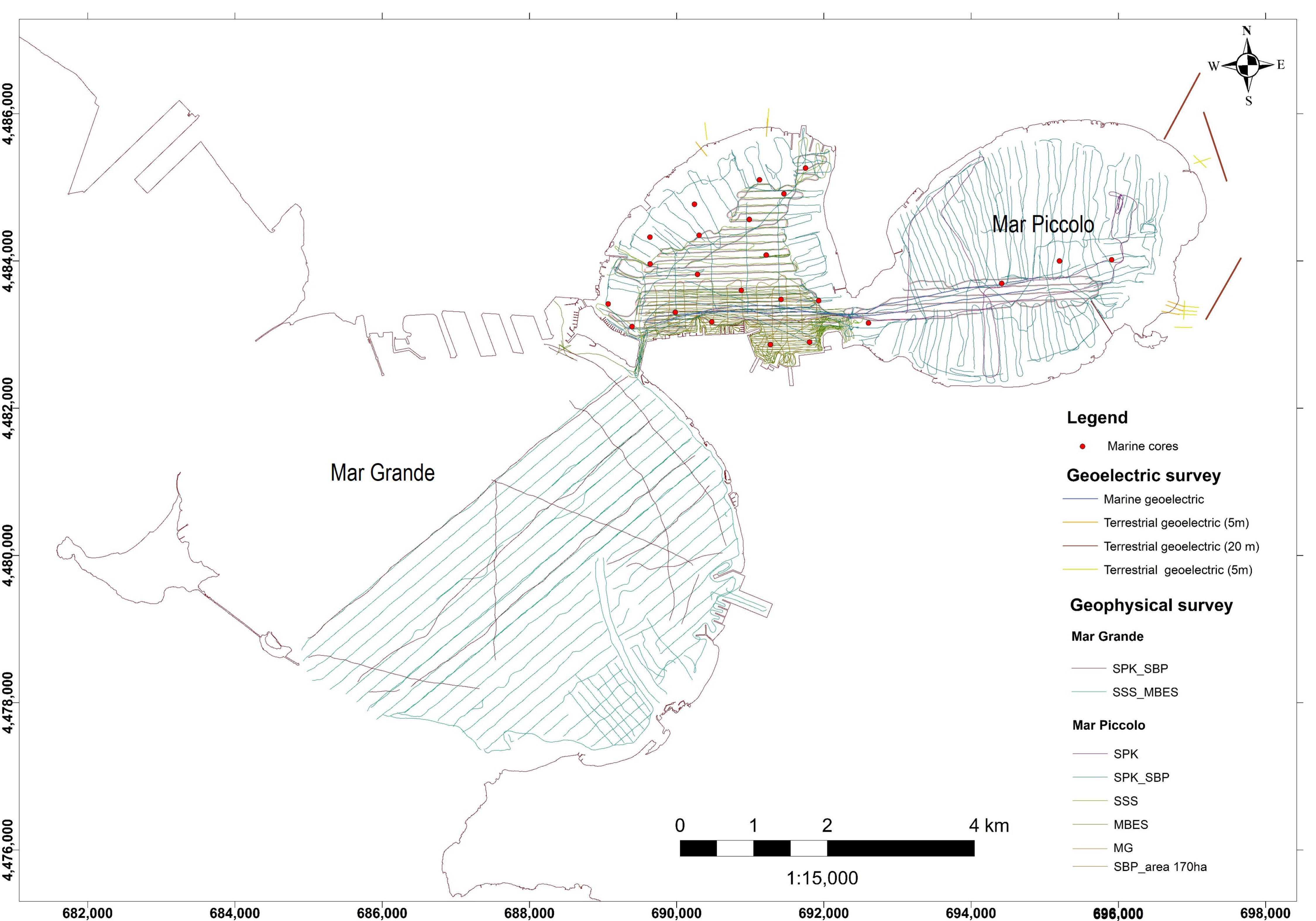
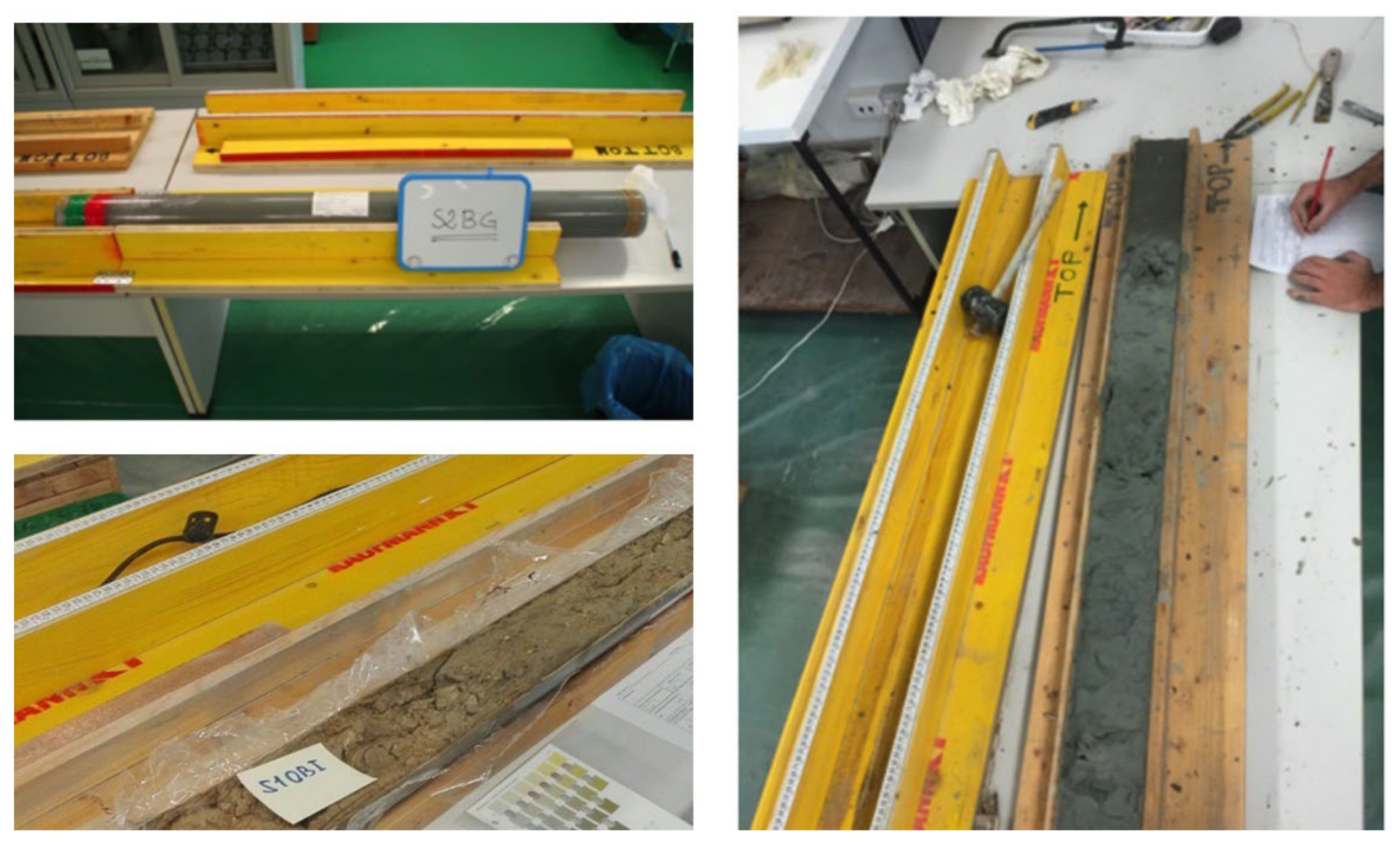
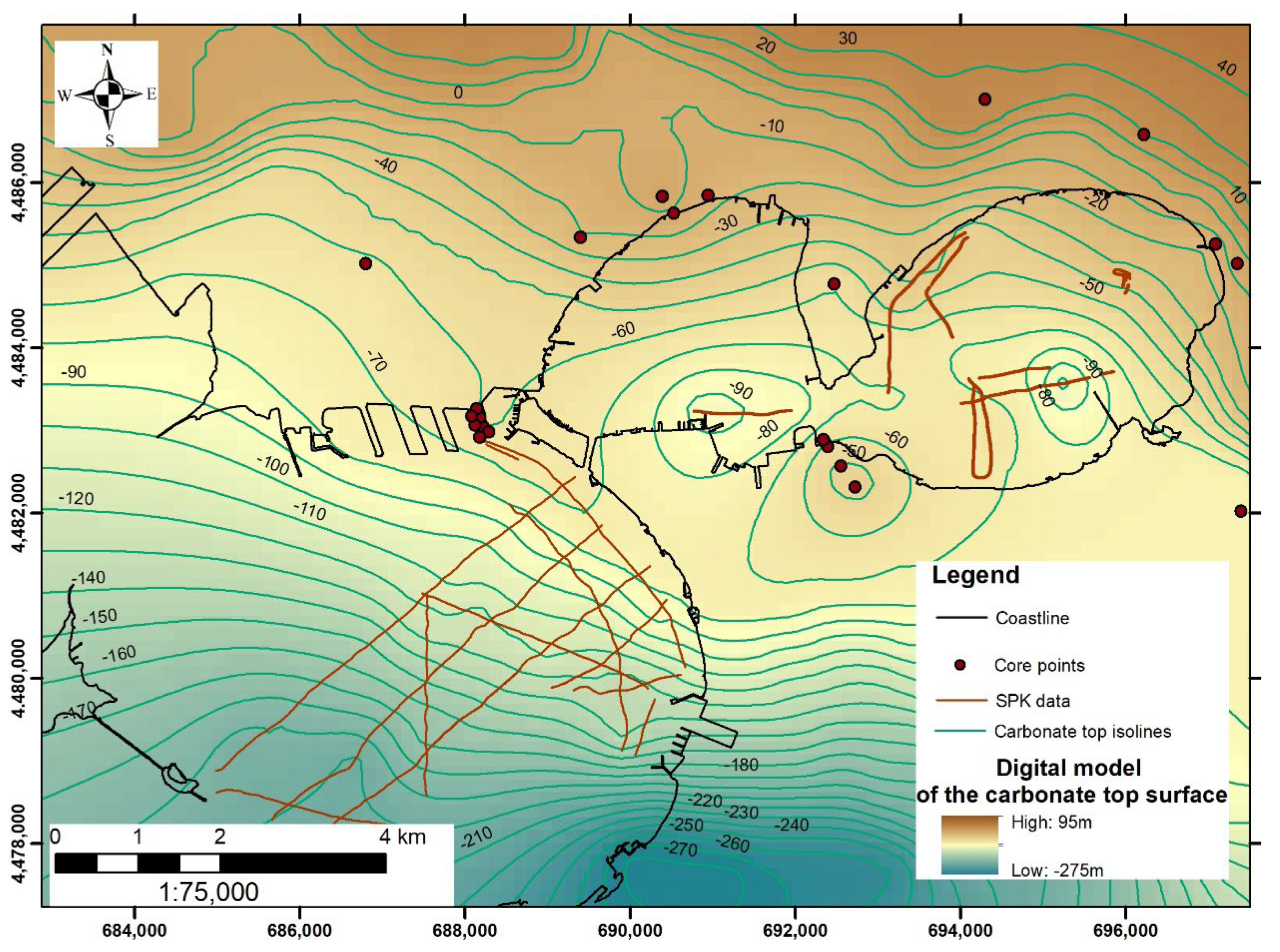
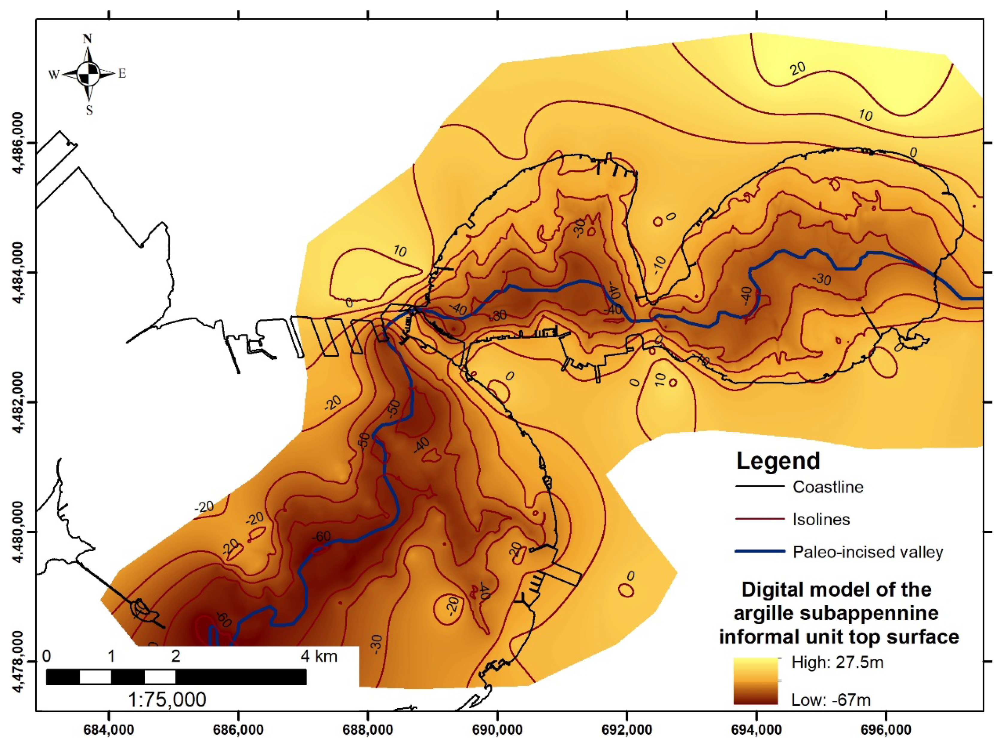
4. Summary of the Characterisation Activities Founded by the Special Commissioner for Urgent Measures of Reclamation, Environmental Improvements, and Redevelopment of Taranto from 2015

The awareness of a widespread environmental risk [25][26][27], the epidemiological data indicating values above the national average for every type of cause of death [28], and the need to protect a territory characterized by a high socio-economic and geo-environmental relevance led, in 2014, to the definition of the Special Commissioner for the area of Taranto, who promoted an interdisciplinary study for the integrated characterization of the coastal system in the SIN_07 perimeter. In this framework, new surveys were envisaged to obtain both direct and indirect data necessary for the geological, sedimentological, mineralogical, geochemical, and biological characterisation of the area.
Specifically, in the first phase of study, started in 2016, the Mar Piccolo basin was investigated, while in the second phase (started in 2017), the survey activities were carried out in the Mar Grande basin. In Figure 1, the navigation lines defined for the acquisition of the geophysical data (Side Scan Sonar-SSS, MultiBeam-MBES, Sub Bottom Profiles-SBP, Sparker-SPK, Magnetometric-MG) are indicated (Figure 1). In the Mar Piccolo area, marine, coastal (land–sea interface), and terrestrial geoelectric surveys were also conducted (Figure 1). The profiles’ total length was 6675 m, with an interelectrode spacing of, respectively, 20 m and 5 m for the coastal and terrestrial profiles.
Figure 1. Navigation lines followed for the geophysical and geoelectric surveys carried out in the frame of the activities funded by the Special Commissioner. The positions of the 24 sediment cores carried out in the Mar Piccolo are also indicated.
Regarding the direct analysis, in the period from September 2016 to March 2017, 24 sediment vibrocores were extracted in the Mar Piccolo basin using 1.5 m-long cores (Figure 1) at different sampling depths up to the limit of the argille subappennine informal nit. Each liner was appropriately sectioned so that it could be used for both sedimentological and chemical analyses. Once the cores were transported to the laboratories, a preliminary visual core description was carried out, taking into consideration the following parameters: degree of the drilling process disturbance, color, lithological and granulometric characteristics, sedimentary structures, accessories (shells type, organic material, presence of glauconite or other minerals, concretions and nodules, archaeological findings) (Figure 2). Extensive physical and chemical analyses in the sediment samples from the First Bay basin were carried out. These activities included the determination of the following parameters: sediment granulometry, redox potential, organic matter, water content, organic and inorganic pollutants (PCBs, PAHs, TPH, TBT, DTB, MBT), metals (Pb, Cd, V, Ni, Cu, Zn, Hg, Cr, Fe, Al, Mn, As and Sn), and Dioxins and Furans. For the definition of the degree of contamination, the concentrations of the pollutants resulting from the chemical analyses were compared with the site-specific action levels established for the SIN_07 “Taranto” and with the national thresholds (CSC).
Figure 2. Phase of preliminary description of sediment liners from the Mar Piccolo basin.
Detailed description of the technical specifications of the geophysical survey as well as of the analytical procedures for the chemical analyses are reported in Valenzano et al. [29] and Cotecchia et al. [30], respectively. In order to obtain more details on the mineralogical composition of the sediment samples, further analyses were also carried out. These included the acquisition of magnetic susceptibility profiles, the detection of heavy metals in very small concentrations, X-ray Fluorescence (XRF), X-ray Powder Diffraction (XRPD), and Trasmission Electron Microscope (TEM). Further analysis, such as liquid limit, plasticity index, activity index, soil solid-specific gravity, organic matter, void ratio, water content, and liquidity index, allowed estimate chemo-mechanical proprieties of the sediments.
The integrated interpretation of the geophysical data acquired in the Mar Piccolo with chronostratigraphic information derived from direct cores and 14C dating [31] allowed the geometrical relationships between sedimentary bodies to be defined, as well as their lateral continuity, thickness, and depth providing scientific support to the definition of the Holocene morpho-sedimentary evolution of basin [29]. In addition, through the qualitative description of the sediment samples, the main facies were identified and correlated with the seismic units obtained from the analysis and interpretation of the high-resolution single-channel seismic data (SBP and SPK). Specifically, through the interpretation of the SPK profiles, the upper limit of the carbonate substrate (Calcare di Altamura Fm.) was identified (Figure 3), on which, in discordance, it was possible to recognize a thick clayey succession referable to the informal stratigraphic unit of the argille subappennine (Pliocene–Middle Pleistocene) in heteropia with the Gravina Calcarenite Fm. (Pliocene). The digital model of the carbonate-top surface shown in Figure 3 has been obtained by interpolating available data from SPK interpretation and already available core data [29]. On the other hand, the interpretation of the SBP profiles had highlighted the thicknesses and geometries of the post-Last Glacial Maximum (LGM) units, which develop in the incised valley morpho-stratigraphic system. As shown in Figure 4, this structure can be followed with good continuity from the Mar Piccolo basin to the Mar Grande basin [29][32].
Figure 3. Digital model of the upper limit of the carbonate substrate (Calcare di Altamura Fm.) identified through the analysis and interpolation of SPK data (for the submerged area) and core data. Isolines are referred to local mean sea level.
Figure 4. Digital model of the upper limit of the argille subappennine informal unit identified by the analysis of the SBP, SPK data and cores.
The interpretation of the acoustic data (MBES and SSS) allowed the high-resolution morpho-bathymetric setting of the coastal area to be defined, highlighting the morphological features that can be ascribed to local natural assets (i.e., Citri, [33]). In addition, these data represented useful support for the identification and mapping of elements and traces from anthropogenic activities, providing, therefore, an indirect assessment of the human footprint on the seafloor. The analysis of the most recent acoustic data will certainly update the indirect and direct surveys already carried out in the past for the Mar Piccolo area [34][35], integrating the same analysis for the Mar Grande basin (Figure 5).
Figure 5. Distribution of anthropogenic traces detected on the seafloor of the Mar Piccolo (first Bay) and Mar Grande basins through the interpretation of SSS and MBES data.
As far as the results obtained from the analysis of chemical parameters are concerned, they showed a substantial environmental criticality in the southern sector of the First Bay (i.e., the area defined as “Area 170 ha”). As regards the distribution of pollutants along the vertical profile of the sediments, it emerged that the highest concentrations characterize the first sediment layer (0–0.50 m).
As can be seen from the analysis of these data, most of the sediment samples present a concentration of the inorganic compound higher than the site-specific action values. In surface samples relative to cores S02, S03, S04, S05, S06, S16, there are at least six concentrations of inorganic pollutants higher than the limit values. In sediments from core S03 and S06 the CSC limit value for the Hg is exceeded. In Figure 6, the results of the chemical analysis performed on superficial sediments are summarised. Sediment cores are indicated with circles, whose sizes depend on the number of inorganic and organic pollutants exceeding site-specific thresholds.
Figure 6. Sediment cores in the First Bay of the Mar Piccolo basin. The size and the color of the circles are proportional to the number of heavy metals whose concentration in the first layer of sediment (0–0.50 m) has resulted to be above the site-specific action values. S01 does not show any concertation above the site-specific limit, while in the samples from cores S03 and S06, the Hg concentration exceeds the national limit (CSC value).
However, the presence of some pollutants at higher depths, with concentrations even exceeding the threshold limits, infer the occurrence of local mixing phenomena in the more superficial and unconsolidated sediments. In particular, as highlighted by the researchers of [36], who analyzed and mapped the concentrations of the Organotin compounds in sediment samples up to 3 m, the greatest thickenings of reworked sediments were detected mostly in the southern and northwestern areas of the First Bay, where the bathymetric data showed a remarkable perturbation of the seafloor mainly ascribed to anthropogenic activities (e.g., dredging and wrecks). Cotecchia et al. [30] provided the analytical results for chemical, geotechnical, and mechanical proprieties evaluated for sediment sampled from six selected cores (S01, S02, S03, S04, S06, S07) from the sea-floor interface up to a depth of approximately 30 m. The results obtained from the analysis of chemical parameters updated the knowledge on contamination levels in the Mar Piccolo basin. Nevertheless, no analysis has been carried out for the chemical characterization of the sediment from the Mar Grande basin.
Comparing the analytical results obtained during the characterization activities funded by the Special Commissioner with the international sediment quality guidelines ERM and ERL (effects range medium and effects range low), it emerged that the concentrations of As, Cr, Hg, Ni, Pb, Cu, and Zn exceed the ERL values at least in one sample; furthermore, Hg, Ni and Pb concentrations also exceed the ERM values. Specifically, Ni concentrations exceed the ERL values in all the 19 samples, As and Hg concentrations exceed the ERL values in 16 samples (S02, S03, S04, S05, S06, S07, S08, S09, S11, S12, S14, S15, S16, S17, S18, S19 and S01, S02, S03, S04, S05, S06, S07, S08, S09, S11, S14, S15, S16, S17, S18, S19, respectively), Cr concentrations exceed the ERL values in 15 samples (S04, S05, S06, S07, S08, S09, S11, S12, S13, S14, S15, S16, S17, S18, S19), Pb and Cu concentrations exceed the ERL values in 10 samples (S02, S03, S04, S05, S06, S15, S16, S17, S18 and S02, S03, S04, S05, S06, S15, S16, S17, S18, S19, respectively). Finally, Zn concentrations exceed the ERL values in six samples (S02, S03, S04, S05, S06, S16). Considering the ERM values, Hg concentrations are higher in 11 samples (S02, S03, S04, S05, S06, S11, S15, S16, S17, S18, S19), Ni concentrations are higher in all the samples excluding S10 and S10, and Pb concentrations are higher in samples S3 and S6. Nevertheless, it is worth noting that the use of indicators such as ERL and ERM can be considered a first attempt to link the bulk chemistry with toxicity [37][38][39][40]. Chemical concentrations below the ERL value represent a range below which adverse biological effects would rarely be observed; similarly, the ERM values represent a potential range above which adverse effects on biological systems would frequently occur [37].

This entry is adapted from the peer-reviewed paper 10.3390/land11060878

References

  1. Gómez, J.A. SUPERFUND: EPA Should Take Additional Actions to Manage Risks from Climate Change Effects; GAO-20-73; U.S. Government Accountability Office: Washington, DC, USA, 2019; p. 66.
  2. Manzoor, R.; Zhang, T.; Zhang, X.; Wang, M.; Pan, J.-F.; Wang, Z.; Zhang, B. Single and Combined Metal Contamination in Coastal Environments in China: Current Status and Potential Ecological Risk Evaluation. Environ. Sci. Pollut. Res. Int. 2018, 25, 1044–1054.
  3. Minkina, T.M.; Nevidomskaya, D.G.; Pol’shina, T.N.; Fedorov, Y.A.; Mandzhieva, S.S.; Chaplygin, V.A.; Bauer, T.V.; Burachevskaya, M.V. Heavy Metals in the Soil–Plant System of the Don River Estuarine Region and the Taganrog Bay Coast. J. Soils Sediments 2017, 17, 1474–1491.
  4. Micheli, F.; Halpern, B.S.; Walbridge, S.; Ciriaco, S.; Ferretti, F.; Fraschetti, S.; Lewison, R.; Nykjaer, L.; Rosenberg, A.A. Cumulative Human Impacts on Mediterranean and Black Sea Marine Ecosystems: Assessing Current PressuRes. and Opportunities. PLoS ONE 2013, 8, e79889.
  5. Civili, F.S. The Land-Based Pollution of the Mediterranean Sea: Present State and Prospects; IEMed: New Delhi, India, 2010; p. 5.
  6. Lehoux, A.P.; Petersen, K.; Leppänen, M.T.; Snowball, I.; Olsen, M. Status of Contaminated Marine Sediments in Four Nordic Countries: Assessments, Regulations, and Remediation Approaches. J. Soils Sediments 2020, 20, 2619–2629.
  7. Brand, J.H.; Spencer, K.L.; O’shea, F.T.; Lindsay, J.E. Potential Pollution Risks of Historic Landfills on Low-Lying Coasts and Estuaries. WIREs Water 2018, 5, e1264.
  8. ISPRA Siti di Interesse Nazionale (SIN). Available online: https://www.isprambiente.gov.it/it/attivita/suolo-e-territorio/siti-contaminati/siti-di-interesse-nazionale-sin (accessed on 3 May 2022).
  9. Zoumis, T.; Schmidt, A.; Grigorova, L.; Calmano, W. Contaminants in Sediments: Remobilisation and Demobilisation. Sci. Total Environ. 2001, 266, 195–202.
  10. Fichet, D.; Boucher, G.; Radenac, G.; Miramand, P. Concentration and Mobilization of Cd, Cu, Pb and Zn by Meiofauna Populations Living in Harbour Sediment: Their Role in the Heavy Metal Flux from Sediment to Food Web. Sci. Total Environ. 1999, 243–244, 263–272.
  11. Linnik, P.M.; Zubenko, I.B. Role of Bottom Sediments in the Secondary Pollution of Aquatic Environments by Heavy-Metal Compounds. Lakes Reserv. Sci. Policy Manag. Sustain. Use 2000, 5, 11–21.
  12. Spada, L.; Annicchiarico, C.; Cardellicchio, N.; Giandomenico, S.; di Leo, A. Mercury and Methylmercury Concentrations in Mediterranean Seafood and Surface Sediments, Intake Evaluation and Risk for Consumers. Int. J. Hyg. Environ. Health 2012, 215, 418–426.
  13. Baldrighi, E.; Semprucci, F.; Franzo, A.; Cvitkovic, I.; Bogner, D.; Despalatovic, M.; Berto, D.; Formalewicz, M.M.; Scarpato, A.; Frapiccini, E.; et al. Meiofaunal Communities in Four Adriatic Ports: Baseline Data for Risk Assessment in Ballast Water Management. Mar. Pollut. Bull. 2019, 147, 171–184.
  14. Bellas, J.; Nieto, Ó.; Beiras, R. Integrative Assessment of Coastal Pollution: Development and Evaluation of Sediment Quality Criteria from Chemical Contamination and Ecotoxicological Data. Cont. Shelf Res. 2011, 31, 448–456.
  15. Ausili, A.; Bergamin, L.; Romano, E. Environmental Status of Italian Coastal Marine Areas Affected by Long History of Contamination. Front. Environ. Sci. 2020, 8, 34.
  16. ISPRA. Criteri per La Elaborazione di Piani di Gestione Dell’inquinamento diffuso; ISPRA-Manuali e Linee Guida 146/2017; ISPRA: Rome, Italy, 2017; p. 23.
  17. APAT. Manuale per Le Indagini Ambientali Nei Siti Contaminati; APAT-Manuali e linee guida 43/2006; ISPRA: Rome, Italy, 2006; p. 202.
  18. ISPRA. Linee Guida per la Determinazione dei Valori di Fondo per i Suoli e per le Acque Sotterranee; SNPA Linee guida 08/2018; ISPRA: Rome, Italy, 2018; p. 318.
  19. APAT/ICRAM. Manuale per La Movimentazione dei Sedimenti Marini; ISPRA: Rome, Italy, 2007.
  20. Lisi, I.; Feola, A.; Bruschi, A.; di Risio, M.; Pedroncini, A.; Pasquali, D.; Romano, E. La Modellistica Matematica nella Valutazione Degli Aspetti Fisici Legati alla Movimentazione dei Sedimenti in Aree Marino-Costiere; ISPRA: Rome, Italy, 2017; p. 144.
  21. Araneo, F.; Bartolucci, E.; Vecchio, A. Synthesis of the Report “Status of Contaminated Sites Management in Italy: Regional Data”; ISPRA: Rome, Italy, 2021; p. 22.
  22. ISPRA. Elaborazione e Valutazione Dei Risultati della Caratterizzazione Ai Fini della Individuazione Degli Opportuni Interventi di Messa in Sicurezza e Bonifica Del Sito di Interesse Nazionale di Taranto—Mar Grande II Lotto e Mar Piccolo; CII-El-PU-TA-Mar Grande II Lotto e Mar Piccolo-01.06 2010; ISPRA: Rome, Italy, 2010; p. 90.
  23. Labianca, C.; De Gisi, S.; Todaro, F.; Notarnicola, M. DPSIR Model Applied to the Remediation of Contaminated Sites. A Case Study: Mar Piccolo of Taranto. Appl. Sci. 2020, 10, 5080.
  24. Trinchera, G.; Ungaro, N.; Blonda, M.; Gramegna, D.; Lacarbonara, M.; Cunsolo, S.; Renna, R. Approfondimento Tecnico-Scientifico Sulle Interazioni tra il Sistema Ambientale ed i Flussi di Contaminanti da Fonti Primarie e Secondarie Nel Mar Piccolo di Taranto. In Proceedings of the ECOMONDO 2015, Rome, Italy, 3–6 November 2015; p. 7.
  25. Giandomenico, S.; Cardellicchio, N.; Spada, L.; Annicchiarico, C.; Di Leo, A. Metals and PCB Levels in Some Edible Marine Organisms from the Ionian Sea: Dietary Intake Evaluation and Risk for Consumers. Environ. Sci. Pollut. Res. 2016, 23, 12596–12612.
  26. Cardellicchio, N.; Covelli, S.; Cibic, T. Integrated Environmental Characterization of the Contaminated Marine Coastal Area of Taranto, Ionian Sea (Southern Italy). Environ. Sci. Pollut. Res. Int. 2016, 23, 12491–12494.
  27. Cardellicchio, N.; Annicchiarico, C.; di Leo, A.; Giandomenico, S.; Spada, L. The Mar Piccolo of Taranto: An Interesting Marine Ecosystem for the Environmental Problems Studies. Environ. Sci. Pollut. Res. Int. 2016, 23, 12495–12501.
  28. Pirastu, R.; Comba, P.; Iavarone, I.; Zona, A.; Conti, S.; Minelli, G.; Manno, V.; Mincuzzi, A.; Minerba, S.; Forastiere, F.; et al. Environment and Health in Contaminated Sites: The Case of Taranto, Italy. J. Environ. Public Health 2013, 2013, 753719.
  29. Valenzano, E.; Scardino, G.; Cipriano, G.; Fago, P.; Capolongo, D.; De Giosa, F.; Lisco, S.; Mele, D.; Moretti, M.; Mastronuzzi, G. Holocene Morpho-Sedimentary Evolution of the Mar Piccolo Basin (Taranto, Southern Italy). Geogr. Fis. Din. Quat. 2018, 41, 119–135.
  30. Cotecchia, F.; Vitone, C.; Sollecito, F.; Mali, M.; Miccoli, D.; Petti, R.; Milella, D.; Ruggieri, G.; Bottiglieri, O.; Santaloia, F.; et al. A Geo-Chemo-Mechanical Study of a Highly Polluted Marine System (Taranto, Italy) for the Enhancement of the Conceptual Site Model. Sci. Rep. 2021, 11, 4017.
  31. Quarta, G.; Fago, P.; Calcagnile, L.; Cipriano, G.; D’Elia, M.; Moretti, M.; Scardino, G.; Valenzano, E.; Mastronuzzi, G. 14C Age Offset in the Mar Piccolo Sea Basin in Taranto (Southern Italy) Estimated on Cerastoderma Glaucum (Poiret, 1789). Radiocarbon 2019, 61, 1387–1401.
  32. De Giosa, F.; Lisco, S.N.; Mastronuzzi, G.; Moretti, M.; Rizzo, A.; Scardino, G.; Scicchitano, G.; Valenzano, E.; Capasso, G.; Velardo, R.; et al. La Geologia Marina di Taranto: La Base Fisica per Lo Studio Dell’inquinamento Antropico Nel Settore Settentrionale Del Mar Ionio. In Abstract Book della Società Geologica Italiana, “La Geologia Marina in Italia, Quarto Convegno dei Geologi Marini Italiani"; Chiocci, F.L., Budillon, F.B., Ceramicola, S., Gamberi, F., Loreto, M.F., Senatore, M.R., Spagnoli, F., Sulli, A., Eds.; Società Geologica Italiana: Rome, Italy, 2021; p. 74.
  33. Valenzano, E.; D’Onghia, M.; De Giosa, F.; Demonte, P. Morfologia Delle Sorgenti Sottomarine Dell’area di Taranto (Mar Ionio). Mem. Descr. Carta Geol. It. 2020, 105, 65–69.
  34. Bracchi, V.; Marchese, F.; Savini, A.; Chimienti, G.; Mastrototaro, F.; Tessarolo, C.; Cardone, F.; Tursi, A.; Corselli, C. Seafloor Integrity of the Mar Piccolo Basin (Southern Italy): Quantifying Anthropogenic Impact. J. Maps 2016, 12, 1–11.
  35. Tursi, A.; Corbelli, V.; Cipriano, G.; Capasso, G.; Velardo, R.; Chimienti, G. Mega-Litter and Remediation: The Case of Mar Piccolo of Taranto (Ionian Sea). Rend. Fis. Acc. Lincei 2018, 29, 817–824.
  36. Massari, F.; Cotugno, P.; Tursi, A.; Milella, P.; Lisco, S.; Scardino, G.; Scicchitano, G.; Rizzo, A.; Valenzano, E.; Moretti, M.; et al. Mapping of Organotin Compounds in Sediments of Mar Piccolo (Taranto, Italy) Using Gas Chromatography-Mass Spectrometry Analysis and Geochemical Data; IEEE: Piscataway, NJ, USA, 2021; pp. 21–26.
  37. Long, E.R.; Macdonald, D.D.; Smith, S.L.; Calder, F.D. Incidence of Adverse Biological Effects within Ranges of Chemical Concentrations in Marine and Estuarine Sediments. Environ. Manag. 1995, 19, 81–97.
  38. Long, E.R. Calculation and Uses of Mean Sediment Quality Guideline Quotients: A Critical Review. Environ. Sci. Technol. 2006, 40, 1726–1736.
  39. O’Connor, T.P. The Sediment Quality Guideline, ERL, Is Not a Chemical Concentration at the Threshold of Sediment Toxicity. Mar. Pollut. Bull. 2004, 49, 383–385.
  40. Birch, G.F. A Review of Chemical-Based Sediment Quality Assessment Methodologies for the Marine Environment. Mar. Pollut. Bull. 2018, 133, 218–232.
More
This entry is offline, you can click here to edit this entry!