Nowadays, there are many available applications supporting travelling around the city, but how does one choose the ones that will be the most useful and convenient for daily trips to destinations such as work, study or leisure. The applications will provide information on how to get from one place to another, what means of transport to use, how long the journey will take, what the travel cost will be, when the tram, bus, metro or train will arrive, the current location of the means of transport, etc. Some applications also offer the possibility of buying tickets, renting a car, a moped or an electric scooter. The most commonly used travel planning applications include [32]: E-podróżnik, Google Maps, Jakdojade, Kiedyprzyjedzie.pl, Mobile MPK, Moovit, myBus online, Transportoid.
1. E-Podróżnik.pl
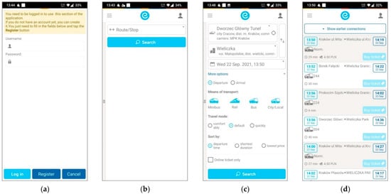
E-podróżnik.pl. is an application that makes it possible to combine public and intercity transport, it also allows the purchase of tickets for several means of transport such as minibus, rail, bus and city/local. The ticket offer of the e-podróżnik.pl application is limited to national and international tickets, but does not offer the option to purchase city transport tickets. The application has a single desktop, where the connection search engine and links to other application tabs are located (
Figure 1a–d). The planner is equipped with a trip filter which allows the passenger to specify their trip by setting a number of parameters. The user also has the possibility of searching only for the journeys for which tickets are sold online. This application is equipped with a function “My tickets”, which stores tickets that are pending, active, archived and cancelled. In addition, the application allows the user to enter basic data in advance (the Account Data tab). For those searching for a transfer route, E-podróżnik.pl provides such information as total travel duration, duration of particular stages of the journey, waiting time for a transfer vehicle, the distance to the bus stop from the starting point, the distance between transfer points, time needed to get to the bus stop, the route including the stops of a given transport line and information on the carrier. Another interesting feature of the application is the “Money box”, which allows the user to top up a virtual account, from which the user can then pay for the purchased tickets. The application is free of charge. It can present the timetables of public transport in more than 30 cities in Poland. Moreover, the user has the possibility of checking public transport timetables abroad in such countries as Belarus, Czech Republic, Estonia, France, Germany, Great Britain, Italy, Latvia, Lithuania, Russia, Spain, Ukraine—the total of 1500 carriers (
https://mobile.e-podroznik.pl (accessed on 20 January 2021)).
Figure 1. Summary of selected tabs of the E-podróznik.pl application: (a) logging in a new user; (b) searching for routes and stops; (c) defining detailed travel options; (d) information on possible connections between the defined points.
2. Google Maps
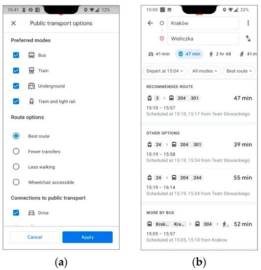
Google Maps is a mobile application created by Google. Initially, it was designed for people travelling on foot or by private transport. Relatively recently, it has also been addressed to public transport users thanks to an extension called Google Transit. Available for Android and iOS smartphones, the app allows the user to define public transport options such as preferred modes, route options and connections to public transport (Figure 1a). As soon as the user enters a starting point and the destination point, the app automatically generates a route for the different modes of public transport and presents all the possible options for the route and the estimated travel time (Figure 2b).
Figure 2. Overview of selected Google Transit tabs: (a) public transport options, route options; preferred modes; (b) the tab with information about possible connections between the defined points.
Mode selection preferences can be adjusted at any time. The application also has a route filter, which displays only those public transport vehicles that are adapted to the needs of disabled users. Google Maps displays the connections with changes, navigates the traveller from the starting point to the stop, presents the total journey time and the time of each journey stage, displays all stops of a given transport line, and additionally indicates the distance to the stop or between stops that the traveller needs to cover. The app allows users to combine journeys by public transport with the use of city bikes. The application is available at no charge. The user can check the accessibility of public transport in more than 15,000 cities in the world (
https://www.google.com/maps (accessed on 16 December 2020)).
3. Jakdojade
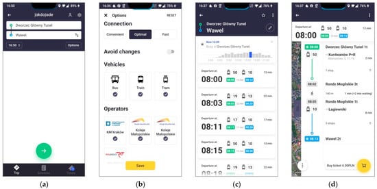
Jakdojade is a Polish application which is often chosen by the users of larger cities or agglomerations to support travel planning. It was designed by CITY-NAV Spółka z o.o. Available for Android and iOS, the app has several configurable tabs. If the GPS location is not activated, the user selects the location where the journey is to be made from a closed list. Only then is it possible to select the starting point and the destination (Figure 3a). From here, in the Options tab, it is possible to indicate the type of route, the minimum transfer time, the type of vehicle (e.g., low-floor vehicles, which is important for disabled people in wheelchairs) as well the public transport operator (Figure 3b). In addition, the user defines the time parameters of their journey (time and day of departure and arrival). Once the key data have been defined, the user is presented with route alternatives (Figure 3c). After selecting one of these, detailed information about the journey is provided including journey times, number of stops and waiting time (Figure 3d). At this point it is possible to purchase tickets for the selected journey. The basic version of the application is free of charge. The premium version of the app allows for real-time tracking of the location of public transport vehicles. The application features not only the function of planning journeys in urban transport, but also in rail transport and it offers access to the timetables of nearly 50 cities in Poland.
Figure 3. Overview of the Jakdojade application tabs: (a) selection of starting points and destinations; (b) options for selecting the type of route, means of transport and public transport operators; (c) routing options; (d) detailed information on the selected route.
4. KiedyPrzyjedzie
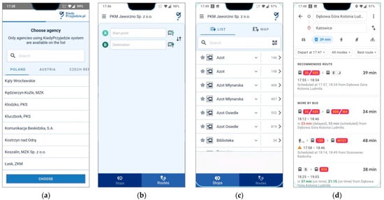
KiedyPrzyjedzie is an official application of Operibus Sp. z o.o. combining the functions of a dynamic passenger information system and a tool to manage the fleet of public transport vehicles. It is compatible with Android and iOS. The application is dedicated in particular to smaller and medium-sized towns. KiedyPrzyjedzie only informs passengers about the public transport vehicles that will arrive at a given stop within 4 h. However, the passenger has no possibility of tracking the location of the vehicle on the map in real time (online). The application’s interface is not very sophisticated, as it is only possible to select the agency of public transport (Figure 4a). In the Starting point and Destination tab (Figure 4b), the user can select the desired stop (Figure 4c). In the next step, the app redirects the user to Google Maps. In contrast to other apps, this one does not require any logging-in, does not have any route filtering options or the option of ticket purchasing. KiedyPrzyjedzie is available for 81 cities in Poland and several cities in Austria and the Czech Republic.
Figure 4. Overview of the tabs of the KiedyPrzyjedzie app: (a) choose agency Poland, Austria and Czech Republic; (b) selecting the starting point and destination; (c) selecting from a list of stops; (d) selecting route options on the Google Maps platform.
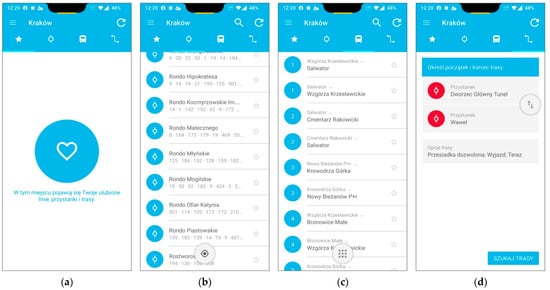
5. Krakow Pod Reka
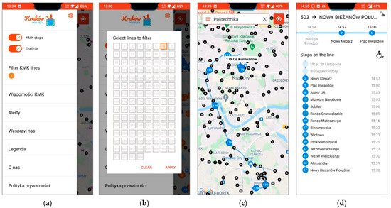
An application developed by independent authors, designed to facilitate travel by various means of public transport; this application uses Google Maps and information from external services including the location of buses, trams, rental cars (Traficar) and bicycles (Wavelo). In the case of public transport, the user receives information about the scheduled and actual departure time, as well as information on delays. The solution is characterised by a relatively low level of complexity. The user can set the display of Cracow’s public transport stops (Figure 5a—KMK stops), or car locations (Figure 5a—Traficar). Moreover, it is possible to filter the display of public transport lines (Figure 5b,c). If a specific line is indicated, the user is informed about the departures from the consecutive stops and whether the means of transport is accessible to disabled passengers (Figure 5d). The presented solution is dedicated only to the city of Krakow.
Figure 5. Overview of the Krakow pod ręką app tabs: (a) main menu; (b) selection of the line number to be filtered; (c) visualisation of the public transport line route; (d) list of stops of the given public transport line.
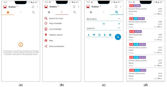
6. mobileMPK (BusNavi)
mobileMPK is a Polish mobile application developed by the MobiCORE company. In other languages than Polish it is known as BusNavi. It is available for Android smartphones. Just like the Jakdojade application, mobileMPK contains three main tabs: (1) favourites (Figure 6a), (2) redirections to connections, timetable from a given stop, available city bike stations in the vicinity, address finder, maps and the option for sending the coordinates of where the user is located (Figure 6b), (3) defining the departure and arrival points and setting the parameters of the journey (Figure 6c). mobileMPK is available in two versions: a free light version and a paid version Pro. In the case of the latter, no advertisements are displayed to the user. In addition, it is also possible to add the timetable of your own preferred lines. The application is additionally extended with a function of displaying delays and positions of buses in real time in the cities where such a solution is implemented. In the case of connections with transfers, mobileMPK provides the time for each stage of the journey, including the time for arrival at the stop and the waiting time for the means of transport at the designated stop (Figure 6d). The app allows the user to search for low-floor vehicles by selecting the appropriate route filtering option. Thanks to the location function, the traveller can also check the available city bike stations. The application uses Google maps to visualise the route. mobileMPK allows users to view public transport timetables for over 60 cities in Poland, the UK, Ireland and the US.
Figure 6. Overview of the tabs and information windows of the BusNavi application: (a) favourites; (b) redirection to connections, timetable from a given stop, available city bike stations nearby, address finder, maps and the possibility of sending the coordinates of where the user is located; (c) defining the start and end point and setting the trip parameters; (d) information window for suggested variants of trip routes.
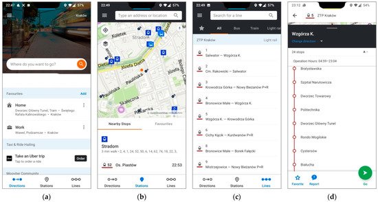
7. Moovit
Moovit is an Israeli mobile application using OpenStreetMap maps to support public transport trip planning developed by the company of the same name—one of the world leaders in mobile applications dedicated to public transport. The application is available for Android and iOS mobile phones. Similar to the previously described applications, it also has three main tabs: (1) “Directions” which is a connections search engine, featuring favourite destinations (suggested: home, work) and an option that allows the user to order Uber (
Figure 7a), (2) “Stations” where stops are presented on the map (
Figure 7b), (3) “Lines” containing timetables for the following lines: bus, tram and train (
Figure 7c). The proposed route is displayed as a straight line with a list of stops (
Figure 7d). It should be noted at this point that the application makes it possible to monitor a journey in such a way that the user, having previously set a destination, will be notified to get off before the final stop. After the trip, it is possible to rate the quality of the public transport service. In addition, the passenger using the application receives information about detours or changes to the timetable. Moovit has a journey-plan function which allows the user to filter the routes, search for a connection with the minimum number of transfers and the minimum walking distance to the stop. The app also gives the user the option to choose their preferred mode of transport, with a choice of bus, train, tram, bike and electric scooter. The application is free of charge. In its database, it has passenger information from 3400 cities and 112 countries all over the world—about 7500 public transport operators. The Moovit application can be used in 32 Polish cities (
https://moovit.com (accessed on 10 January 2022)).
Figure 7. Overview of selected tabs and information windows in Moovit: (a) directions (b) stations; (c) lines; (d) proposed route information window.
8. myBus
myBus is an application which is embedded in the passenger information system (SIP) of the MUNICOM.premium software developed by PZI TARAN Spółka z o.o. The application is available for both Android and iOS smartphones. In contrast to other applications, myBus online is adapted for the visually impaired, the function works independently on the basis of continuous reading of the current GPS position, which is used to find the nearest bus stop. The application informs the visually impaired user about the distance they have to travel from their location to the bus stop. Moreover, if the user is already at a bus stop, the application reads out the lines of public transport that depart from it and the current time. The main advantage of myBus Online is the GPS tracking of public transport vehicles. Thanks to this function, the user obtains a more precise time of arrival of a means of public transport at a given stop, i.e., the actual departures including the time of delays or speed-ups of vehicles which are not included in the timetable. The application’s main screen displays a closed list of cities where it is possible to search for a route (Figure 8a). In the next stage it is possible to use a list of functions of the application (Figure 8b). As in other applications, after defining the starting and destination points and the number of transfers, the user is presented with proposed routes (Figure 8c,d). myBus uses Google maps to visualise the route. The application is available in an online and offline mode. In contrast to the offline mode, the online mode keeps the timetables up to date and provides access to the nearest departure boards. Importantly, the programme uses QR codes which can be found on the stops. The application enables journeys in 48 cities, of which 45 are in Poland.
Figure 8. Overview of selected tabs and information windows in myBus: (a) “Directions”; (b) “Stations”; (c) “Lines”; (d) proposed route information window.
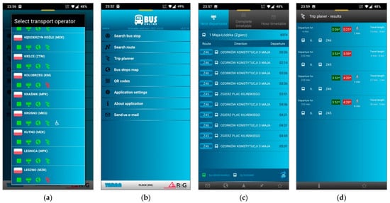
9. Transportoid
Transportoid is FTL Software’s timetable application for Android and iOS smartphones. Its interface consists of four main tabs: (1) “Favourites”, where the user can add favourite routes (Figure 9a), (2) “Timetables”, containing timetables for each stop in the city (Figure 9b), (3) “Lines” containing timetables for each public transport mode (Figure 9c) and (4) “Direction”, a connection search engine (Figure 9d).
Figure 9. Overview of the four basic tabs of the Transportoid application: (a) “Favourites”; (b) “Timetables”; (c) “Lines”; (d) “Direction”.
Transportoid allows the user to search for the connections with a minimum transfer time, a maximum transfer time and a minimum distance to the stop that the traveller has to cover. The application has a function of indicating low-floor vehicles. Transportoid users are kept up to date with all changes in the functioning of public transport including timetables, each upgrade is updated in real time. The basic version of the application is free of charge, those who want to use more advanced functions such as displaying selected timetables on the desktop, grouping stops and GPS functions, have to pay a fee. The application allows the user to set individual reminders for the purchase of season tickets, and it also offers them the offline option. As one of the described solutions, it has an interface in Polish only. The application offers access to the timetables of 71 cities in Poland (as of 15 September 2021).
This entry is adapted from the peer-reviewed paper 10.3390/en15103493