Your browser does not fully support modern features. Please upgrade for a smoother experience.
Please note this is an old version of this entry, which may differ significantly from the current revision.
Subjects:
Geography, Physical
The theoretical basis of permafrost landscape studies originated in the developments of Soviet physical geographers and landscape scientists. Traditional classifications, mapping techniques, and applied interpretations in landscape studies have not previously used permafrost criteria. Therefore, researchers of permafrost landscapes have used them, eventually adapting them to the conditions of permafrost based on the goals and objectives of the research.
- permafrost landscape
- classification
- mapping
1. Permafrost Landscapes as an Object of Study
About a quarter of the land surface area is occupied by permafrost landscapes. In Russia, they occupy about 65% of the territory. These landscapes mainly occupy high-latitude and high-altitude locations, are distinguished by harsh natural conditions, and are characterized by the development of specific cryogenic processes and phenomena.
Permafrost landscapes have been the subjects of environmental–geocryological studies focused on studying territories’ vulnerability to technogenic impacts [6,34,49,56,57,58,59]. The development of landscapes often leads to an ecological imbalance once the disturbance becomes one of our time’s pressing problems.
The study of the main relationships between the components of the natural environment is carried out by creating multifactorial models of the environment or integral systems in the form of a landscape. The landscape is a set of interrelated objects and natural phenomena representing historically established, continuously developing geographical complexes [60]. In other words, this is a spatially limited set of components united by a relatively close interaction [26]. Any landscape definition implies a unified system of morphological (external) and internal (lithogenic) factors.
In permafrost conditions, the development of landscapes and their transformation or restoration after disturbance largely depends on the properties of the permafrost—temperature regime, cryogenic structure, ice content, and active layer thickness. The leading nature of the cryogenic factor in northern landscapes is determined by the specifics of the environment of the northern regions, primarily the presence of ice in the lithogenic base and phase transitions during freezing and thawing.
This understanding of the landscape corresponds to modern ideas about geocryological systems, which are understood as a special type of geosystem in which energy and mass transfer lead to the formation and existence of a specific mineral–ice [61]. Defining the role of the cryogenic factor in the functioning and differentiation of the landscapes of the north requires a certain revision of taxonomy, classification, and mapping methods. In this regard, permafrost distribution and temperature, cryogenic structure, ice content, and active layer thickness have been proposed as criteria for the classification and mapping of permafrost landscapes [43]. Close to this definition are the cryogenic geosystems of Melnikov et al. [62].
Vegetation cover significantly influences the temperature distribution of the permafrost and active layer thickness. The role of biogenic factors is essential in the functioning and development of permafrost landscapes. At the present stage of environmental development, human influence greatly affects the functioning of landscapes. Technogenic disturbances cause the activation of cryogenic processes, leading to restructuring of permafrost landscapes. Permafrost conditions change significantly in technogenic systems, such as industrial complexes, reclamation systems, agricultural lands, etc. These complexes belong to anthropogenic (technogenic) landscapes [68,69].
The relationship between landscape morphological features and permafrost characteristics is powerful, and this is especially true for the environmental problems of permafrost. Therefore, the permafrost landscape, which is a complex territorial interweaving of environmental components, ensures the equilibrium state of the natural environment in the permafrost zone or tends to do so after a disturbance.
The permafrost landscape should be characterized by the properties of permafrost. A distinctive feature of permafrost landscapes is that complexes with different permafrost characteristics, such as differences in the development of ice wedges or contrasting ground temperatures (−4 or −1 °C), represent other classification units [43].
Permafrost is the main system-forming factor. Changes in ground temperature and active layer thickness, ice content, and cryogenic processes determine the state of the permafrost landscape, which can lead to a loss of stability.
2. Permafrost Landscape Mapping
Normal mapping of permafrost landscapes in northeastern Eurasia began in the 1980s. However, this was preceded by pre-landscape mapping based on physical–geographical generalizations; these were geomorphological maps. A classic example of permafrost studies based on geomorphological units is Soloviev’s work on the permafrost zone in Central Yakutia [14], which is still in great demand. Ivanov [18] used geomorphological zoning to assess the distribution of ground ice and the sensitivity of the surface to anthropogenic impacts.
The ground temperature and permafrost thickness were analyzed by Nekrasov [17] using landscape zonality in northeastern and southern Siberia. The schematic maps of Nekrasov well reflect the patterns of permafrost distribution in various mountainous areas of this immense territory.
Vasiliev’s monograph, “Regularities of seasonal thawing of soils in Eastern Yakutia” [48], is practically a permafrost landscape work, although landscape classifications were not used. Like previous works, this study of one of the permafrost’s main characteristics—the active layer’s depth spatial distribution—was carried out based on the physical–geographic systematics of relief, soils, and vegetation. Compiled by Vasiliev, the “Map of thawing soils of Eastern Yakutia” at a scale of 1:2,500,000 [48], presented as an inset map to the monograph, is of value for studying permafrost landscapes. The primary method was the imposition of two layers: geological–genetic complexes with a specific lithological composition of 23 units and plant groups of 20 units. The map perfectly reflects both the latitude-zonal and altitudinal-zonal differentiation of vegetation and the active layer thickness. This work is considered the first permafrost landscape work on northeastern Eurasia.
Further permafrost landscape studies were carried out regularly. The monograph “Permafrost landscapes of the development zone of the Lena-Aldan interfluve” [49] became one of the first significant works on permafrost landscape studies. The monograph was devoted to frozen landscapes and was written based on two years of field research materials along the Tommot-Nizhny Bestyakh railway development zone (Yakutsk). The studies were carried out at the level of terrain types (subtypes), with their identification based on stratigraphic–genetic complexes (alluvium Q4, alluvium Q2–3, lacustrine-alluvial Q2–3, eluvial Q4, etc.), each with a peculiar complex of ground and vegetation. Ten physical–geographical regions were distinguished by a relatively homogeneous terrain type (subtype) combination. Each type (subtype) of terrain in the region was assessed by sensitivity to the activation of cryogenic processes after disturbances. Attached to the monograph was an inset map, “Landscape-cryoindication map of the development zone of the Lena-Aldan interfluve” from Tommot to Yakutsk, with the allocation of types (subtypes) of terrain and regions with a table of permafrost landscape characteristics.
In the late 1980s and early 1990s, the Melnikov Permafrost Institute compiled a permafrost and landscape map of the Yakut ASSR at a scale of 1:2,500,000 [50], with an extensive explanatory note [51]. The map reflected 22 terrain types in terms of geological and geomorphological features and 26 types (subtypes) of landscapes in terms of bioclimatic features. The types of terrain—inter-alas, alas, moraine, outwash, low terrace, glacier-water-valley, upland, slope, etc.—differed in stratigraphic–genetic complexes, cryogenic structures, and volumetric ice content of surface deposits. The types (subtypes) of landscapes were characterized by relatively similar climate characteristics: freezing and thawing indices, types of vegetation, and their productivity. Ground temperatures and active layer thickness were systematized by overlaying the terrain types and landscape types (subtypes). Thus, each landscape classification unit was characterized by specific combinations of permafrost parameters. Such a classification showed a close combination of landscape and permafrost conditions necessary for environmental assessments.
Based on combinations of terrain types and landscape types (subtypes) and geological and geomorphological structures, the permafrost landscape zoning of the Yakut ASSR territory was compiled. A total of 54 permafrost landscape provinces were identified, with relatively homogeneous combinations of terrain types and types (subtypes) of landscapes in three physiographic regions: central Siberia, northeastern Siberia, and the mountains of southern Siberia. In addition to methodological descriptions of the mapping, the explanatory table contained a landscape cadaster comprising a combination of geological, geomorphological, soil, and plant characteristics in types of terrain in each of the 54 permafrost landscape provinces. Thus, the map and the explanatory note have become reference material for those interested in the permafrost and landscape conditions of Yakutia.
In addition, many permafrost landscape maps of various scales were compiled for various developed territories of Yakutia. Map scales varied from detailed (1:5000–1:25,000) to medium scale (1:100,000–1:300,000) to small scale (1:500,000–1:2,500,000). Large-scale maps reflected permafrost landscape conditions at the taxonomic level of a facies [98,99,100], medium-scale maps reflected at the level of terrain types (subtypes) [101,102,103], and small-scale maps overlaying terrain and landscape types [104].
In 2018, the Melnikov Permafrost Institute team updated the permafrost landscape map [50] to receive new permafrost data based on satellite images and a change in the mapping technology: the transition to GIS technologies (Figure 1). The new permafrost landscape map of the Republic of Sakha (Yakutia) at a scale of 1:1,500,000 [105] showed partially change classification, both in types of terrain and in types (subtypes) of landscapes such as groups of vegetation. The authors identified 20 terrain types. The main difference was that the types of terrain were not distinguished into plain and mountainous when the stratigraphic–genetic complexes of surface deposits were the same. Instead of the types (subtypes) of landscapes, the authors used plant groups to better show the contrast between ground temperature and the active layer thickness. The total number of vegetation groups was 36. The map legend shows 145 permafrost landscapes—combinations of terrain types and plant groups—compared with 87 permafrost landscapes on the 1991 map.
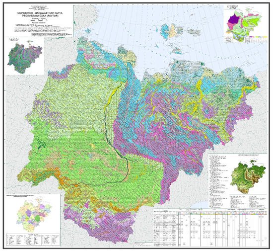
Figure 1. Permafrost landscape map of the Republic of Sakha (Yakutia) on a scale of 1:1,500,000 [105].
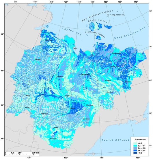
Using GIS technologies, Shestakova et al. [55] modeled individual maps of ground temperature, active layer thickness, ice content of surface deposits (Figure 2), and cryogenic processes using the permafrost landscape map [51]. Previously, permafrost temperature interpretations had also been modeled based on the permafrost landscape map of the Yakut ASSR at a scale of 1:2,500,000 [39,40,41]. Along with permafrost landscape maps, permafrost maps were compiled, which are necessary to determine the degree of vulnerability of permafrost landscapes. These works include the assessment and sensitivity of carbon accumulations in the permafrost of northeastern Yakutia [106], the assessment of the stability and degradation of permafrost in eastern Chukotka [107,108], and maps of yedoma in northeastern Eurasia and North America [109].
3. Study of the Dynamics and Evolution of Permafrost Landscapes
The study of the dynamics and evolution of permafrost landscapes in northeastern Eurasia has been widely developed. A characteristic study of the dynamics of permafrost landscapes is that of the stages of development of thermokarst landforms. The applicability of the Yakut names in classifying the stages of thermokarst development was first noticed by Efimov and Grave [110]. They noted that the initial thermokarst subsidence in its further development turns into “eie”, subsided depressions, where the grooves between the hillocks are filled with water. The next stage in thermokarst development is the “duede”—a rounded lake with low but steep banks and high-centered polygons in the bottom. Over time, the “duede” turns into a water-filled lake with a flat bottom and steep banks. The subsided lake eventually turns into an alas.
Later, Soloviev [14] supplemented and improved this classification of thermokarst landforms (Figure 3). He singled out the following stages:
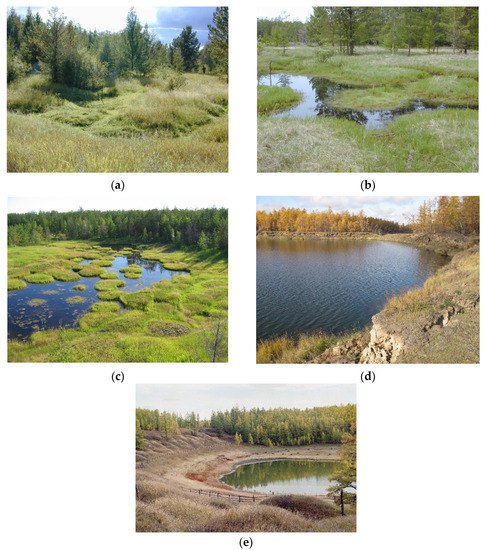
Figure 3. Stages of thermokarst landforms (Central Yakutia). (a)—bylar, (b)—eie, (c)—duede, (d)—tympy, (e)—alas.
- (1)
-
The initial bylar—slightly lowered areas deformed by separate subsidence holes and troughs.
- (2)
-
Bylar—lowered areas where the troughs connected, forming a high-centered polygon depression.
- (3)
-
Eie is a high-centered polygon depression. In the eie, the troughs between the hillocks are filled with water [110].
- (4)
-
Duede is a depression with pronounced banks, with high-centered polygons at the bottom and banks. Efimov and Grave [110] noted that it is filled with water.
- (5)
-
Tympy is the first stage of alas. The underground ice at the bottom of the basin melted. The floor of the depression is leveled by alas sediments. The depression is sharply expressed. Usually, tympy is a completely subsided depression with a full lake [110].
- (6)
-
Alas is a depression with a relatively flat, leveled floor and steep, sharply defined banks. Evaporation of water forms alas from the tympy [110].
Permafrost landscape conditions are used in paleogeographic studies. Here, we can trace the evolution of landscapes over a long period of development, as some landscape and climatic conditions have been replaced by others [113,114,115,116,117]. During periods of warming in northeastern Eurasia, larch woodlands with an admixture of spruce developed in the modern tundra zone. In the contemporary larch middle taiga, larch forests combined with spruce and pine forests grew. During periods of cooling in central Yakutia, the areas of yerniks increased, and in Allered (until 11,500 years ago), tundra-steppes dominated.
Based on the work of palaeogeographers, we assessed permafrost conditions during periods of Holocene warming [118]. The optimum ground temperature in the Holocene in the tundra areas was 5–6.5 °C warmer than at present (before the current warming, or before 1980), in the northern taiga by 2.5–4 °C, and in the middle taiga by 1.5–2.5 °C. In assessing the evolution of permafrost conditions in eastern Siberia in the Pleistocene–Holocene, one can be guided by the work of Fotiev [119], which is based on the interpretation of the Baikal chronicle of diatom deposits [120].
Permafrost landscape studies have played a significant role in determining the modern dynamics of the natural environment during disturbances, primarily during forest fires and deforestation. Restorative successions after disturbance reflect the restoration of permafrost conditions. The characteristics of successional stages in the development of permafrost landscapes and their duration have been determined [98,121,122,123]. In central Yakutia, the complete restoration of the permafrost landscape after disturbance takes 120–130 years. Detailed studies on the succession’s influence on the active layer thickness in central Yakutia were carried out by Gabysheva (Lytkina) [35,124,125]. The study of succession stages of development served as the basis for mapping the dynamic state of permafrost [53].
The permafrost landscape features of the territories have impacted the increase in soil temperature during the current climate warming. Thus, there has been an increase in soil temperature from average long-term values of 0.5 °C in central Yakutia to 2–3 °C in Arctic Yakutia [134,135]. Such changes have led to the degradation of permafrost landscapes on ice-rich permafrost (Figure 4). Many researchers have noted the more intense response of tundra permafrost landscapes, especially in the formation and expansion of thermokarst lakes [136,137,138]. Boike et al. [139] identified changes in lake areas, vegetation, land surface temperatures, and the area covered by snow using data from remote sensing. Such changes will undoubtedly have an impact on the state of permafrost landscapes.

Figure 4. Ice-wedge exposure (a) and abandoned arable land from thermokarst development in the ice-rich permafrost (b) near the Syrdakh settlement in central Yakutia.
The change in soil and vegetation cover determines the dynamic state of the permafrost landscape and the evolution of the environment. It is also essential for predicting the change in permafrost in the context of global warming.
Lapenis et al. [140] noted that the biomass of green parts (leaves, needles, understory, and green forest floor) had a steady upward trend from 1960–2000 during modern climate change. Analysis of satellite data revealed a slight increase in the normalized difference vegetation index (NDVI) in northern Eurasia. The development of biota productivity can slow down the increase in ground temperature and active layer thickening in boreal landscapes because vegetation cover is a good heat insulator [141,142].
The stability of permafrost landscapes depends not only on permafrost conditions, but also on the dynamics and evolution of biota. The widespread activation of forest fires in northeastern Eurasia during climate warming in recent decades has caused a disruption of the permafrost temperature regime and the subsequent development of restorative successions. Permafrost disturbances cause an imbalance in greenhouse gases, illustrating the dynamism of changes in permafrost landscapes. In the permafrost landscapes of Yakutia, studies are being carried out on both carbon dioxide [148,149,150,151] and methane content in permafrost [152,153,154] and their emissions [155,156,157,158,159].
The degradation processes of permafrost and the restoration of native landscapes require developing adaptation measures to life in these new conditions. Permafrost landscape studies can benefit this development. Recently, suggestions for permafrost temperature management by controlled grazing to ensure permafrost sustainability and reduce greenhouse gas emissions have attracted interest [147,160,161,162].
This entry is adapted from the peer-reviewed paper 10.3390/earth3010028
This entry is offline, you can click here to edit this entry!