Your browser does not fully support modern features. Please upgrade for a smoother experience.
Please note this is an old version of this entry, which may differ significantly from the current revision.
The social and economic impact of expansive soils has been historically significant and is becoming more important in recent years as urban centers expand into areas covering such soils. The research mentioned here are meant to help in understanding the relationship between the spatial distribution of the causal factors and the magnitude of this phenomenon. Its findings can be of benefit to state authorities and other policy makers, as well as the construction industry, in planning future urban development and the maintenance of existing infrastructure.
- ground heave/settlement
- expansive clay
- seasonal motion
- rainfall
1. Introduction
Expansive soils significantly affect many countries worldwide, damaging buildings, road networks and other infrastructure. The mechanisms involved in this phenomenon are complex, and the factors that play an active role in its development can be divided into two categories: the preparatory and the triggering ones. In the first category are the geotechnical and the geological conditions, while in the second one, the moisture variation of the ground caused by rainfall infiltration and evapotranspiration, the leakage of water supply and sewage pipes, the fluctuations of the water table, etc. The economic losses caused by this hazard is in the scale of billions of dollars each year [1][2]. In fact, the annual cost of damages due to expansive soils surpasses that of other natural geohazards, namely earthquakes and landslides [3]. Examples of regions with expansive clays include: China [4]; Sudan [5][6]; Australia [7][8]; Saudi Arabia [9][10]; United Kingdom [1][11]; Canada [12], and Sweden [13]. Several studies (numerical or experimental) have been carried out in order to estimate the connection between the degree of damage to buildings and the distribution of ground moisture underneath their foundation, e.g., [14][15][16].
To date, Earth Observation (EO) technologies have been widely used to carry out studies investigating the failure mechanism of various natural hazard, such as landslides [17][18][19], land subsidence [20][21][22], flood [23][24], etc., along with field surveys and numerical modeling. However, the use of these technologies for the investigation of vertical ground movements due to the seasonal swelling and shrinkage of clays is at a relatively early stage [25][26][27]. Nonetheless, InSAR has been successfully used in numerous studies in the last decades for studying a phenomenon also pertaining to predominantly vertical ground movements, i.e., the land subsidence due to changes in the groundwater level. These studies estimate the degree of influence of the factors that play an active role on the future extent and magnitude of land subsidence, such as the geological conditions [28][29], tectonic structure [30], hydrological conditions [31][32][33][34][35][36][37][38][39], the thickness of the compressible formations [36][40], the urbanization [20][41] and the land use [40][42].
The present research employs Interferometric Synthetic Aperture Radar (InSAR) data to investigate the phenomenon of ground swelling/shrinkage due to seasonal moisture changes in an expansive clay formation and assess the degree of influence of the causal factors. The methodology developed herein relies on the integration of EO technologies, pre-existing local data and experience, conventional geotechnical research and the use of statistical analysis within a GIS environment. All the factors which affect this phenomenon, namely plasticity index [43][44][45], clay and montmorillonite content [4][46][47], expansive soil layer thickness and depth [6][15], were compiled and thematic maps were constructed using spatial analysis tools. It has long been established that the larger are the values of plasticity index, clay content and montmorillonite content, the larger the tendencies for swelling/shrinkage are expected to be [1][2]. Subsequently, the ground movements in the area as inferred by InSAR for the period between 16 November 2002–30 December 2006 [48] were processed. Finally, multivariate linear regression analysis using Lasso was carried out, elucidating the degree of influence of the main causal factors [49].
The research area is the central and eastern part of the city of Nicosia, which is the capital of the Republic of Cyprus (Figure 1). Expansive clays cover extensive areas of the island of Cyprus. The majority of these geomaterials are bentonitic clays deposited during the late Cretaceous period as deep-water sediments produced by the hydrothermal weathering of the basaltic rocks of the Tethyan oceanic crust. Nowadays, the outcrops of these extremely expansive materials are rather limited and can be found on the ground surface in a relatively small number of areas along the southern coast and in the mountainous region of Paphos District. However, the weathering of these old formations produced sediments that were redeposited in basins north and south of the axis of the Troodos mountain range, eventually resulting in the creation of the marls of the Nicosia geological formation, which are outcroppings particularly in areas of important urban development in the island of Cyprus, such as the cities of Nicosia, Larnaca and Paphos. These outcrops in combination with the climate of the region, which is characterized by rainy winters and very dry summers, are responsible for various types of damages to buildings and other infrastructure. More specifically, the seasonal variations of the degree of ground saturation that happen inside the so-called active zone, the depth of which is of the order of 3m to 8m, cause soil expansion (during the rainy winter months) or soil shrinkage (during the dry summer months). This phenomenon puts strain on buildings founded on such soils, which more often results in cracks in in-fill walls. In more extreme cases, these cracks may propagate to the structural frame. According to a previous study [50], which surveyed a part of the city of Nicosia where the marl is extremely expansive, 58 out of 96 buildings showed various degrees of damage due to ground swelling/shrinkage, characterized as moderate/severe for 7 of them. It is worth mentioning that in areas where the slope of the ground is >3° damages are substantially more frequent. This phenomenon may be due to the ratcheting effect on sloping terrain [51][52]. Τhe annual cost of repairs in the surveyed area of 1.75 km2 was estimated to be more than 2.4 million euros (based on 2002 prices), while the decrease in real estate value was estimated at 2 million euro per year.
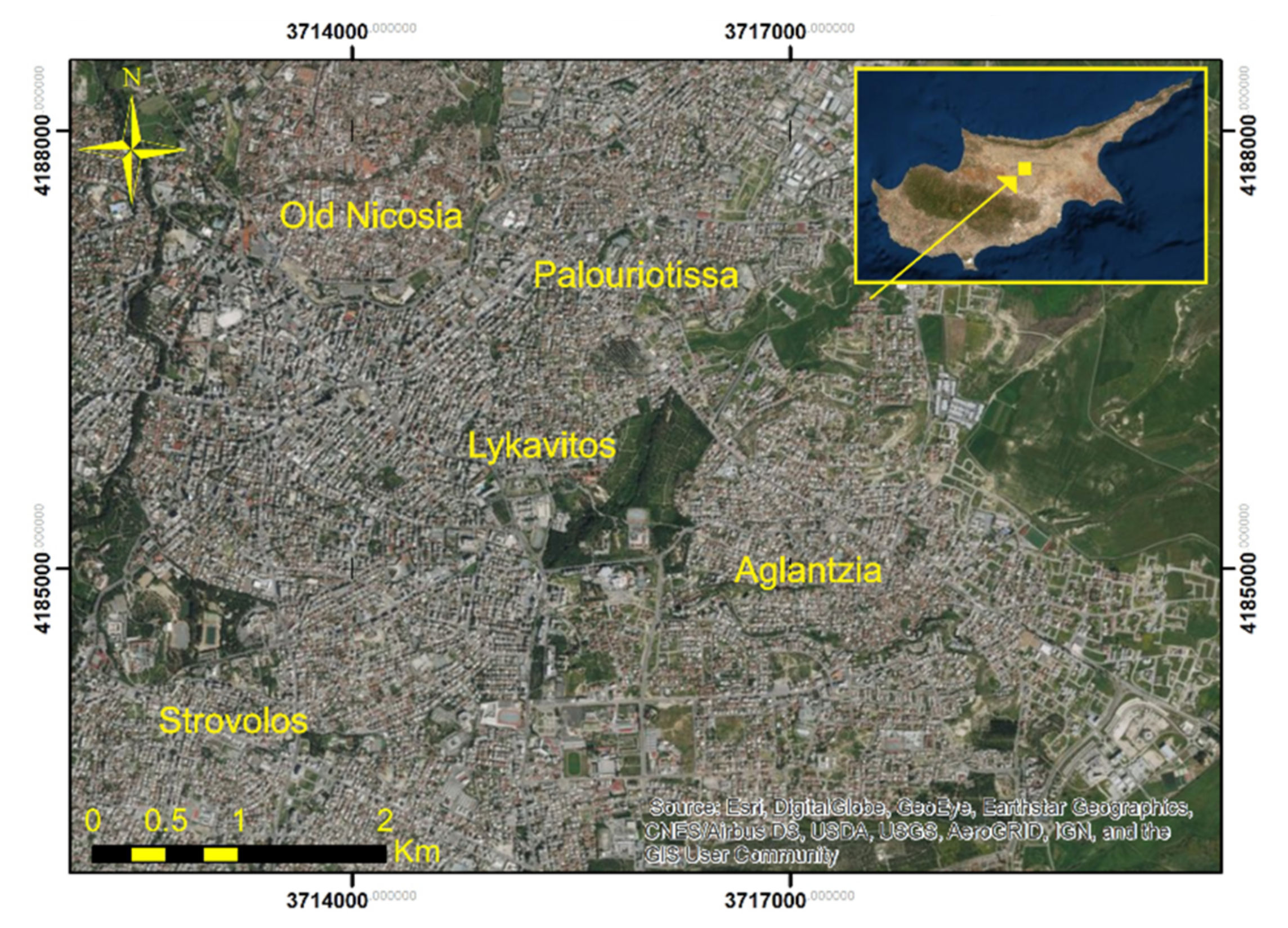
Figure 1. Satellite image of the study area.
Based on the above, it is obvious that the social and economic impact of expansive soils has been historically significant and is becoming more important in recent years as urban centers expand into areas covering such soils. The results of the present research are meant to help in understanding the relationship between the spatial distribution of the causal factors and the magnitude of this phenomenon. Its findings can be of benefit to state authorities and other policy makers, as well as the construction industry, in planning future urban development and the maintenance of existing infrastructure.
2. Current Insights
The investigation of this phenomenon through the EO technologies presents some inherent difficulties. Firstly, the creation of time series with the average vertical displacements per year could not provide the researchers with meaningful conclusions due to the repeated small amount of swelling followed by shrinkage on a yearly basis. Secondly, the magnitude of the vertical displacement is affected the pressures applied by the structures. Therefore, in an urban environment where high rise buildings coexist with smaller ones and buildings with shallow foundations coexist with buildings founded on piles (in which case the vertical movement of the superstructure is drastically limited), the SAR data should be treated with great caution. In order to overcome the above weaknesses, this research relied on estimates of the vertical movement amplitude, in the form of the difference between the maximum and minimum displacement observed in a given time period, calculated for each PS point. This way, the intensity of the vertical deformation fluctuations (and not their tendency) becomes evident. Furthermore, the PS points that did not belong to buildings were selected and treated separately as free field points aiming to mitigate the fact that ground movements depend on the applied vertical stress.
Based on the Interferometric Synthetic Aperture Radar (InSAR) data from the PanGeo project between 16 November 2002 and 30 December 2006, it was found that the seasonal fluctuations of the ground surface are of the order of a few tens of millimeters, with a maximum value of the order of 30–35 mm. This amplitude is clearly larger than the 5 mm to 10 mm observed in regions of France [25][26], signifying the highly expansive nature of the Nicosia marl in conjunction with the arid climate of Cyprus. Nonetheless, the value of 30–35 mm is not far from the 20–25 mm amplitude observed in eastern parts of Paris where severe damages to buildings due to soil swelling/shrinkage frequently occur [27]. It should be stressed that the vertical displacement amplitudes are similar both throughout the examined 4-year period and for each hydrological year separately. This observation confirms the periodicity of the phenomenon and indicates that the main cause of ground volume changes is the seasonal fluctuation of ground moisture inside the active zone of Nicosia marl due to the climatic factors (precipitation, temperature, sunlight, wind). Furthermore, as presented in Figure 2, the ground heave follows the periods of heavy precipitation with a delay of two to four months. This observation suggests that ground wetting in Nicosia marl happens slowly and abrupt activations are not expected (in the absence of other triggering factors). Nonetheless, a monotonic trend in the vertical displacement (subsidence) can also be noted in Figure 2, which extends from the middle of the 2nd hydrological year to the end of the examined time period. Given that the water table in the study area is not exploited and lies very deep in the largest part (and, thus, is largely unaffected by the atmospheric factors), this non-periodic subsidence can be attributed to the differences between each year in the total amount of precipitation that occurs during the months in which the evapotranspiration is small (i.e., the winter months).
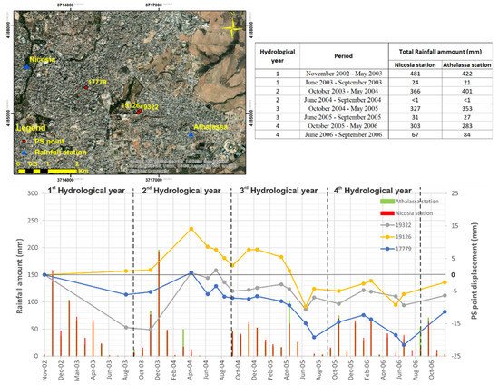
Figure 2. Times series of displacement (right axis) and rainfall (left axis) for three characteristic PS points.
From the geotechnical point of view, the vertical displacements amplitudes appear to correlate well with the thematic layers of plasticity index and clay content. A similarly strong correlation is observed between the average vertical displacement rate and the clay content in the upper 1m of the soil profile in large regions of Australia [53]. These observations are in good agreement with numerous laboratory studies, which corelate the swelling pressure (the pressure required to hold the soil, or restore the soil, to its initial void ratio when given access to water) to soil plasticity and clay content [54][55]. Nonetheless, future research could also examine other factors that are known to affect this phenomenon, such as liquid limit and dry unit weight.
Statistical analysis shows that strong and meaningful correlations can be established between ground movement amplitude and the causal factors (plasticity index, clay content, montmorillonite content, marl thickness inside the active zone and depth of its upper boundary), provided that PS points that are located on buildings are excluded and only “free-field” PS points are retained in the dataset. Lasso regression reveals that the most important variable controlling the amplitude of ground heave and settlement is the marl’s plasticity index, followed by the depth of the upper boundary of the marl layer (i.e., the thickness of the non-expansive soil cover) and the clay content. Yet, it must be pointed out that this research relied on a geotechnical data from boreholes that are sparsely and unevenly distributed. The present findings could be reinforced by applying the proposed approach to a region with a denser and more evenly spaced cloud of points of geotechnical data.
This entry is adapted from the peer-reviewed paper 10.3390/rs14061440
This entry is offline, you can click here to edit this entry!