Your browser does not fully support modern features. Please upgrade for a smoother experience.
Please note this is an old version of this entry, which may differ significantly from the current revision.
Mountain Permafrost Hydrology can be defined as “the geoscience that describes and predicts the occurrence, circulation, and distribution of the water within high and cold mountainous terrain”.
- permafrost
- rock glacier
- hydrology
- climate change
- runoff
1. Introduction
Climate change is expected to have a major impact on mountain regions, leading to reduced water security around the world [1,2]. Consequently, mountain water resources are expected to be stressed due to increases in air temperature, sublimation, and evapotranspiration, as well as changes in precipitation patterns, particularly in arid and semi-arid zones, such as the Dry Andes of South America [1]. Mountain glaciers around the world are receding under a changing climate (e.g., [3,4,5]), shifting the predominant dynamics of the mountain cryosphere from glacial to periglacial (Figure 1), which has, depending on the area, implications for mountain water resources [6]. The influence of this shift from glacial to periglacial dynamics on mountain hydrology is due to major differences in the rate at which these two environments respond to atmospheric changes, superimposing shifts in hydrology due to projected changes in snow cover and precipitation pattern. Surface ice responds much faster to climatic change than ground ice, which is insulated from the atmosphere by the active layer and often by snow [6,7]. Because heat transfer to the subsurface is attenuated according to the physical properties of the ground, increases in heat fluxes acting on permafrost due to climate warming are delayed and dampened compared to for glaciers, resulting in melt rates of ground ice being substantially lower than for surface ice (Figure 1). While melt rates of surface ice would remain relatively constant if climate warming rates did not change, ground ice melt rates could decrease with time in response to a thickening of overlying unfrozen materials (i.e., active layer deepening), provided that the unfrozen material is not removed by mass movement processes [8,9,10].
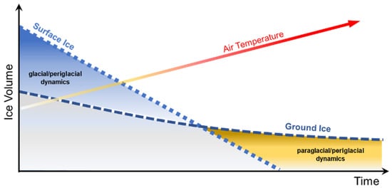
Figure 1. Schematic illustrating possible changes in future surface (glacial) and ground (periglacial) ice volumes in non-polar mountain regions and the shifting influence of glacial and periglacial dynamics over time (after [6]). The rate at which this transition will occur likely varies substantially between mountain regions.
The freeze–thaw dynamics of surface ice, i.e., found in glaciers and on lakes, are vastly different from the dynamics of ground ice, which can be found ranging from near the ground surface seasonally during the winter to depths of hundreds of metres in some regions. Therefore, ground ice may be much older than surface ice [11,12], specifically in smaller surface ice bodies that are found in mountainous environments (Figure 2). To put this into perspective of a global hydrological cycle, average residence times of groundwater can range from ~200 to 10,000 years (depending on spatial scale), whereas residence times of lakes can be ~100 years, and rivers as low as two weeks [13]. An attempt to summarize the complexity of flow paths and temporary water storages in a glacial/periglacial watershed is presented in Figure 2. Every drop of precipitation, whether deposited in liquid or solid form, will ultimately leave the watershed, and snow patches, glaciers, or rock glaciers, act as temporal storages along with lakes and groundwater, i.e., they are not the origin of the water recorded as discharge. The figure focuses on the pathway from precipitation to surficial flow; however, some water either sublimates or evaporates. Specifically in the high and arid mountain regions of the world, sublimation rates can be substantial, reaching more than 80% [14,15]. A raindrop or a snowflake can pass through various temporary storages or cryoforms before it leaves a mountainous watershed. For example, it may start as snow, be compressed to firn and to surface ice (a glacier), from where it can melt, potentially infiltrate, freeze within the active layer for one winter (seasonal ground ice), melt again and infiltrate to greater depths, then later flow towards a permafrost body where the droplet segregates and remains in the ground as ground ice for several thousand years. Eventually, this part of the permafrost degrades, releasing the drop of water that then flows as groundwater until it typically surfaces at a spring and joins the surface drainage system. Following this schematic, it also becomes apparent that the active layer influences near-surface water storage and drainage [16,17,18].
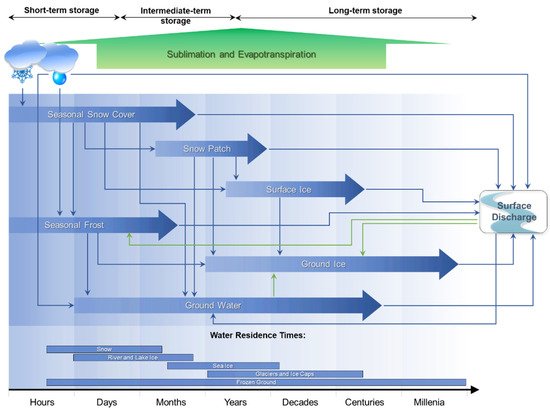
Figure 2. Flow diagram, illustrating main water storages available withing the cryosphere and associated residence times (after [19]) from which water can contribute to runoff and how a drop of water may move through different storages. The green arrows indicate where water from surface discharge may flow back into a storage.
Glacier hydrology has long been a major focus of scientific research and the role of glaciers within the hydrological cycle is well understood, with seasonal melt from glaciers known to contribute substantial amounts of water to runoff (e.g., [20,21,22]). Conversely, it is unclear whether ground-ice melt from thawing mountain permafrost contributes meaningful amounts of water to the water cycle. Furthermore, most research in this area has focused on rock glaciers [23,24], which represent only a small component of mountain permafrost. Limited research has been completed on the influence of climate change in mountain watersheds characterized by the presence of permafrost and studies to date highlight the lack of data in these environments [25,26,27,28]. In the context of rock glaciers in the Dry Andes, conclusions of two recent studies [27,29] illustrate how the current state of knowledge on mountain permafrost hydrology is conflicting. Falaschi et al. [27] stated that “Rock glaciers near the Andean mountains of central and northwestern Argentina provide an important supply of water for agriculture, but data on their number, size, geographic distribution and altitudinal range are poorly known”, suggesting that the role of rock glaciers contributing to streamflow had been established. Conversely, Schaffer et al. [29] wrote more recently that “There is insufficient knowledge available to adequately quantify the hydrological contribution of rock glaciers to streamflow within the semiarid Andes [27°–35° S]”; hence, they concluded that “It is therefore important to quantify the hydrological importance of rock glaciers in order to provide adequate protection to ensure sufficient water availability for future generations.”.
The mountain permafrost environment is highly heterogeneous, particularly outside of polar regions, as temperature and tropical mountains are subject to large spatial and temporal differences in climate conditions and ground conditions can vary substantially over short distances. Therefore, the extrapolation of conclusions from limited rock glacier hydrology studies to generalize permafrost hydrology of mountain watersheds is a scientific oversimplification that creates critical limitations for water management planning and policy making and may be raising wrong expectations related to freshwater availability. This generalized perspective neglects complex differences and interactions between glacial and periglacial environments in terms of process and scale, limiting the ability of scientists to estimate how climate change induced modifications to the hydrology of mountain watersheds could influence natural and socio-economic environments in the future. This knowledge gap amplifies uncertainties in projections of future change and increases associated environmental risks, consequently presenting challenges for water management, project development, and mitigation planning.
2. Permafrost Hydrology
Hydrology can be defined as “the geoscience that describes and predicts the occurrence, circulation, and distribution of the water of the earth and its atmosphere” [31]. Permafrost is defined as ground (soil or rock, including ice and organic material) that remains at or below 0 °C for at least two consecutive years [32]. The presence of permafrost influences water flow paths and, to a lesser extent, water sources and storage mechanisms [33]. The widespread distribution of permafrost across the globe [34] and its unique hydrological effects have led to the study and development of the field of permafrost hydrology.
The primary influence on water movement exerted by permafrost is through physically constraining flow. Permafrost thermal state is less important since water flow is possible at temperatures even below 0 °C; for example, in saline waters or under certain grain size and pressurized conditions [35]. Williams and van Everdingen [36] provide a detailed overview of permafrost hydrology in Arctic regions and state that “Permafrost […] acts as a confining bed, and both its composition and distribution have a significant influence on patterns and rates of groundwater flow. […] Groundwater discharge may be restricted to the lower, central part of many river valleys where the permafrost is discontinuous. In some valleys, the resulting strong upward movement of groundwater causes quick conditions and instability of the affected streambeds. In the region of continuous permafrost, unfrozen zones penetrate the permafrost only where salinity of the groundwater prevents freezing, or where heat transfer from a body of surface water or from discharging subpermafrost water is sufficient to maintain the unfrozen condition.”.
In 1975, Dingman [37] concluded that hydrologic effects of permafrost are profoundly non-static due to long-term climate change. He further indicated that permafrost acts as an aquitard, restricting the movement and recharge of groundwater, and stressed that resultant effects on hydrology are not necessarily the expected straightforward ones of increased runoff and flashier streamflow. Studies available at that time suggested long hydrograph recessions for streams draining permafrost areas, and some large basins had a high proportion of their runoff occurring as groundwater outflow [37]. Runoff percentages estimated for small central and northern Alaskan watersheds were moderately high (around 50%) and mostly snowmelt. Dingman [37] continued to stress that seasonal freeze–thaw processes have important dynamic hydrologic impacts influencing infiltration in complicated ways: sometimes increasing and sometimes decreasing it.
In a key reference on permafrost hydrology [33] and a paper published just before that [38], Woo and colleagues concluded that “Permafrost hydrology should continue to be of practical relevance. Hydrologic knowledge is of paramount importance to water supply, flood control, construction, and operation of development projects in permafrost regions. Hydrologic information available to other branches of science and engineering is crucial to the management of fish and wildlife habitats, forestry and agriculture, aquatic waste disposal and community health.”. The authors continue stressing that despite recent advances in the understanding of permafrost hydrologic processes, ground-based observations, which are still scarce in polar regions, are critical and there are substantial limitations when those are substituted by remote sensing.
Permafrost hydrology is controlled by the spatial and temporal peculiarities of permafrost. The technical definition of permafrost, as presented by Muller [32], has already been introduced. This can be illustrated schematically, as shown in Figure 3, for steady climatic conditions where the changes in temperature over time and with depth are presented. If the minimum and the maximum temperature at each depth is plotted, the figure on the right is obtained, which is known as the temperature trumpet curve [30]. Freezing and thawing processes, also referred to as frost action, occur within the top layer of the ground, known as the active layer, which is not part of the permafrost. In the winter, when the ground is completely frozen, the active layer forms an aquitard. As the active layer develops during the summer, flow within these shallow soil layers may occur, changing the overall flow regime as it becomes dependent on the soil’s hydrological characteristics, often related to unsaturated flow conditions [39]. In addition, the time of concentration increases as the active layer develops. As the active layer starts to refreeze, mainly from the surface, but also to a lesser degree from the permafrost table upwards, flow may initially be limited to an ever-thinning layer that will eventually freeze, creating a completely frozen aquitard once more. Only towards the end of the summer when the active layer is fully developed, water frozen in the permafrost may be released if the active layer penetrates deeper than it had during previous years, hence, permafrost is degrading.
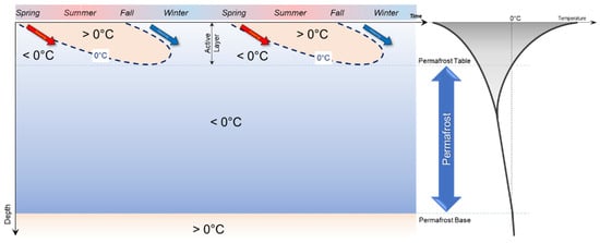
Figure 3. Changes in ground temperature with time (Left) and associated temperature trumpet (Right), showing the minimum and maximum temperatures at each depth recorded during a year. The figure on the left illustrates how the thaw front in the spring and the freezing front in the fall penetrate from the surface, forming the active layer.
Without permafrost degradation, discharge originating from an area with permafrost can be water released from seasonal storage in the active layer (Figure 4) or sub-permafrost groundwater. During the winter, the ground is frozen, and a snow cover may be present. The combined effect of intense solar radiation, high wind speeds and low air relative humidity in many mountain regions of the world results in a substantial amount of snow sublimation [14,15,40]. As the snow cover disappears, surface runoff may occur and complex infiltration processes form, which have been discussed with respect to geohazards [41,42]. As the active layer thickens during the summer, moisture that had been frozen in the previous fall and winter, forming seasonally frozen ground, will melt and can potentially contribute to runoff. It is, however, important to note that active layer deepening is a slow process and therefore the amount of water that can thaw is limited. In order to melt 1 kg of ice, 334 kJ of energy is required [43]. Due to the insulating and, hence, dampening effect of the active layer, the deeper into the ground, the less energy is available for ground ice thawing; therefore, the melting of ground ice and the advancement of the thaw front decelerates over time, similar to the penetration of the freezing front in the winter [43]. The contribution from active layer thaw to the discharge is, therefore, small, and increases noted in the hydrograph are likely related to precipitation, flow through the active layer, or deeper groundwater flow. Watersheds underlain by permafrost tend to have a quick response to precipitation in the summer, resulting in their hydrographs peaking earlier than basins without permafrost [44] (low concentration time). As the ground starts to freeze back, the active layer discharge from permafrost underlain areas ceases. In general, permafrost acts as an aquitard and the active layer acts as a seasonal aquifer and seasonal ice storage from the previous year’s snowmelt, for example.
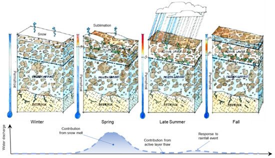
Figure 4. Conceptual sketch for illustrating a simplified hydrograph showing the changes in contribution to water discharge in response to the freeze–thaw action within the active layer. If steady climate conditions exist, ground ice melt from permafrost thaw will not contribute, as there will be no permafrost degradation (Sketch by Derrill Shuttleworth).
The processes described above are further complicated by heterogeneity in the ground conditions that impact the unfrozen moisture content and hydraulic conductivity of frozen or partially frozen ground [45,46,47], and also influence the moisture dependent thermal properties [48] and the ground thermal regime. Pore water freezes as temperature decreases below 0 °C; however, not all pore water freezes, and a substantial unfrozen water content can persist well below 0 °C, depending on the soil properties (Figure 5), pore water salinity, and pore water pressure [49,50]. The decrease in unfrozen water content results in a concurrent decrease in hydraulic conductivity (Figure 5). Permafrost represents a thermal state, not a physical state, such that the ground ice content of permafrost may range from fully ice-saturated to zero volumetric ground ice content, and its hydraulic conductivity may range from its unfrozen and saturated hydraulic conductivity to several orders of magnitude lower. Furthermore, water flow is often responsible for the formation of taliks because of heat advection and convection, i.e., the transport of heat with flowing water [37]. Permafrost degradation is controlled primarily through heat transfer from the ground surface; however, the diffusive and advective processes through supra-, intra-, and sub-permafrost taliks can accelerate degradation and alter local hydrology in complex ways.
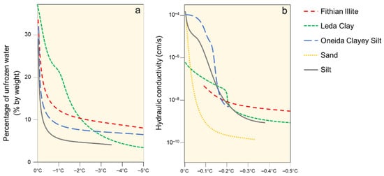
Figure 5. Soil percentage of unfrozen water content (a) and hydraulic conductivity (b) as a function or soil temperature. Modified from [45].
Water and permafrost are interrelated in different ways. Water influences the distribution and thermal regime of permafrost, whereas the spatial distribution, depth, and thickness of the permafrost body has an effect on hydrology, runoff, and infiltration [51]. In areas of discontinuous permafrost, precipitation further influences the depth of seasonal thaw and the ground thermal regime [52]. Specifically, the soil moisture content immediately prior to freezing in the fall determines the ice content of this layer. The amount of surface water and infiltration capacity of the soil then influences the depth of thaw during the following summer [52].
The main effect of permafrost on the hydrology of a watershed is the restriction, but not exclusion, of an exchange between surface waters and subpermafrost groundwater [53]. If the exchange is sufficiently restricted, the result is a perched water table within the active layer above the permafrost table. This vertical flow restriction may result in surficial ponding of water within flat terrain and high rates of surface soil erosion in steeper terrain, where surface runoff is considerable due to limited infiltration [53]. Rising and lowering of the water table between a low-conductivity layer and an overlying high-conductivity layer within the active layer may trigger a threshold response behaviour, similar to the ‘transmissivity feedback’ mechanism [54]. Finally, subpermafrost layers are typical aquifers within permafrost environments and it is not unusual that they are confined [55,56].
3. Mountain Permafrost Hydrology
Hydrological processes within mountainous terrain are strongly influenced by local topography and the type of surficial material. Therefore, it is important to differentiate hydrological processes that occur within polar regions from those where topographic impacts are essential, such as in the Dry Andes. The flow of water, but also mass movements, such as creep of ice-rich sediments, snow avalanches, debris flows, rock falls, or other forms of landslides, are controlled by gravity and local topography [42]. In addition, solar radiation in mountainous terrain varies greatly within short distances in response to slope aspect, elevation, and local shading [57]. Together with microclimatic conditions, this forms a complex and heterogeneous permafrost distribution [58,59,60]. The three main factors controlling this distribution are:
-
The surface energy balance, largely driven by atmospheric conditions, which controls heat inputs to and outputs from the Earth’s surface;
-
The heat derived from the Earth’s interior, which is generally defined by the geothermal gradient at depth; and
-
The presence of surface (lakes or rivers) or subsurface (taliks) bodies of water that do not freeze completely during the winter.
In consequence, the concept of continuous and discontinuous permafrost, as it is used within a polar context, should not be applied within mountainous environments. It is recommended to either use mountain permafrost as a general term that inherently implies the complex and heterogeneous nature of permafrost within a mountainous environment, or a permafrost probability, for example, from a permafrost distribution model [61,62,63]. Regardless of whether a permafrost region is presented in a polar (continuous–discontinuous) context or within mountains, the actual extent of the permafrost is substantially smaller than the extent of a permafrost zone or region [64] and there is also a key depth component associated with permafrost distribution.
In the southern hemisphere, north facing slopes along mountain ridges are typically warmer than south facing slopes because of the difference in solar radiation, impacting the permafrost distribution (Figure 6). With increasing elevation, the extent of the permafrost and its depth increases, and the number of non-permafrost zones decreases. The mountain ridge shown in Figure 6 is located within a permafrost region, i.e., a geographical area where permafrost may be present. However, the continuity within the permafrost body itself decreases with decreasing elevation allowing, even strictly from a thermal perspective, more infiltration and both groundwater recharge and discharge. In parallel, permafrost temperatures increase at lower elevations, further influencing the unfrozen moisture content and hydraulic conductivity of the frozen sediments (Figure 5). Different types of taliks may allow for water to flow through the system, influencing the regional distribution of hydraulic conductivity and, hence, the distribution of relatively permeable and less permeable pathways for groundwater flow.
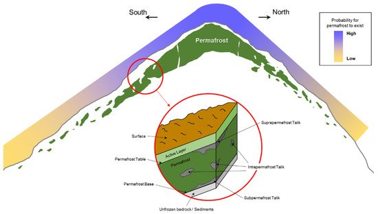
Figure 6. Dependency of the extent of mountain permafrost as a function of elevation and aspect for the southern hemisphere (not to scale). The inset shows different types of taliks that can be found in a permafrost environment and are relevant for water movement (after [45]).
However, while the presence of permafrost and taliks may be critical for understanding groundwater recharge, flow, temporal storage, and discharge, it is essential to consider its presence within the larger context of the local hydrogeological characteristics. Ultimately, permafrost, nor a periglacial cryoform, can ever be the origin of water within a mountainous watershed, but its presence may influence groundwater recharge and surface runoff hydrographs at varying times.
In addition, the hydrology in mountain regions is highly controlled by local weather patterns, air temperature, and elevation, which determine the spatial distribution of precipitation and its physical state (i.e., solid or liquid). In general terms, mountainous environments, which are often composed of a multitude of different landforms (Figure 7), are regulators of the downstream hydrology [65]. Winter precipitation, typically snow, is stored on the surface by accumulation. This is especially true for a glacier dominated watershed that stores water in the form of surface ice and snow. A dry winter landscape forms at high elevation with wetter conditions downstream, where precipitation falls in the form of rain. During spring and summer, when rain is often marginal at lower elevations, surface ice and snowmelt provide water for surficial runoff.
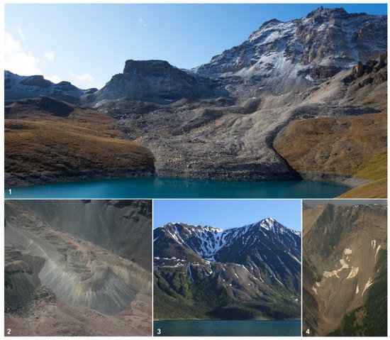
Figure 7. Rock glaciers from different mountain ranges illustrating the variety in the periglacial landforms. (1): Switzerland (lat: 46.150°/lon: 7.528°); (2): Metropolitan Region, Chile (lat: −33.227°/lon: −70.257°); (3): Yukon Territory, Canada (lat: 60.562°/lon: −137.239°; (4): Alberta, Canada (lat: 51.126°/lon: −115.629°). (Photos: L. Arenson).
In mountain catchments, most of the water from snowmelt and rain flows through the ground before entering a stream [23], depending on the local type of surface material that largely controls infiltration capacity. Permafrost directs the hydrology mainly by changing flow paths due to the lower storage capacity induced by the decreased unfrozen water content and hydraulic conductivity of frozen soil [17,66] and bedrock [67,68], or other secondary processes, such as lake damming by rock glaciers [69]. Notable water accumulations were, for example, visible in the 2017 Pizzo Cengalo, Switzerland rock avalanche detachment zone [70,71].
During a research study where near-surface runoff in a coarse grained surface layer and base flow in a finer-grained layer below the permafrost base of a rock glacier were differentiated, Krainer and Mostler [72] concluded that snowmelt was the dominant water source during spring, whereas rain water dominated during summer. Although direct contribution from snowmelt and surface ice melt can generally be identified in watershed hydrographs (Figure 4), there is a fundamental difference between melt of snow ice on the surface compared to melt of ground ice, e.g., from permafrost thaw. Snow and surface ice are directly exposed to atmospheric conditions, including solar radiation and air temperature, and respond instantaneously to changing conditions. For example, runoff from glacier melt is the highest towards the afternoon in direct response to daily maxima of air temperature and solar radiation. Ground ice, on the other hand, is controlled by ground temperatures as it is insulated from solar radiation by snow during the winter and overlying soil or rock during the summer. Further, changes in ground temperature with time and depth depend on the thermal conductivity and heat capacity of the ground, convective heat transfer parameters, and the latent heat of fusion [73]. Therefore, there is a lag for summer temperatures to penetrate the subsurface and to melt any ground ice at depth [43]. Given the temporal lags in temperature propagation with depth, it is challenging to directly link watershed hydrographs for a whole basin to permafrost degradation and associated ground ice melt, or to differentiate between contributions from seasonally versus permanently frozen ground. In response to an increase in the storage capacity of the sediments due to permafrost degradation, a decrease in flood peak runoff and an increase in runoff during recession periods are likely [17]. Frampton et al. [74] used a three-phase water flow model coupled to heat transport to show decreased seasonal variability in groundwater discharge may serve as an early indicator of permafrost degradation, since increased annual mean flows may take a longer time to become apparent.
This entry is adapted from the peer-reviewed paper 10.3390/geosciences12020048
This entry is offline, you can click here to edit this entry!