Your browser does not fully support modern features. Please upgrade for a smoother experience.
Please note this is an old version of this entry, which may differ significantly from the current revision.
Subjects:
Environmental Sciences
Water quality measures for inland and coastal waters are available as discrete samples from professional and volunteer water quality monitoring programs and higher-frequency, near-continuous data from automated in situ sensors. Water quality parameters also are estimated from model outputs and remote sensing. The integration of these data, via data assimilation, can result in a more holistic characterization of these highly dynamic ecosystems, and consequently improve water resource management.
- water quality
- remote sensing
- lake
- estuary
- coastal
- sensors
- management
- interoperability
- integration
1. Introduction
Considered the most valuable natural resource, water is essential to human life and the health of the environment. Accurate monitoring and forecasting of the quality of inland waters, defined here as lakes, reservoirs, estuaries, and coastal marine waters, is fundamental for developing sustainable water resource management strategies and ensuring the health of communities, ecosystems, and economies [1]. Yet, our knowledge of water quality is often disconnected in time and space across various measurement techniques and platforms that may fail to capture dynamic ecosystem changes. This disconnection represents an inefficiency and redundancy in research and monitoring activities. A major challenge for water resource management is how to integrate multiple sources of water quality data and indices into usable information of economic, social, infrastructural, environmental, or administrative value [2]. In addition, realizing the full application potential of emerging technologies requires solutions for merging various measurement techniques and platforms into useful information for actionable management decisions, requiring effective communication between data providers and water resource managers [3].
The Group on Earth Observations (GEO) AquaWatch is a community of practice that aims to develop and build the global capacity and utility of water quality data, products, and information to support water resources management and decision making. GEO AquaWatch targets a wide range of stakeholders, from economists to scientists, to industry representatives, resource managers, nongovernmental groups, and policy makers at the local, regional and national levels (https://www.geoaquawatch.org/, accessed on July 2021).
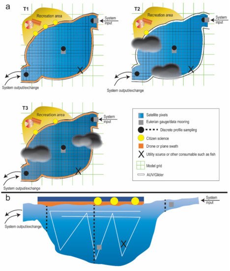
Integration of inland and coastal water quality data products are required for the successful implementation of the United Nations 2030 Sustainable Development Goals (SDG) and the Sendai Framework for Disaster Risk Reduction. Water quality monitoring is relevant toward SDG 6.3 to improve water quality by reducing pollution, eliminating dumping and minimizing release of hazardous chemicals and materials; SDG 6.6 to protect and restore water-related ecosystems; SDG 14.1 to prevent and significantly reduce marine pollution of all kinds; and for disaster risk reduction water quality monitoring and forecasting is critical for the development and assessment of safe water and sanitation systems. GEO AquaWatch provides a conceptual approach for integrating data products to create water quality nowcasts (very short forecast) and forecast. These data (Figure 1) include in situ discrete samples, from professional and citizen science/volunteer (or, community) monitoring programs, automatic in situ sensors, satellite, drone, or aircraft remote sensing, and model outputs.

Figure 1. Conceptual diagram of an integrated sampling scheme in a generic waterbody that may represent a lake, reservoir, estuary, or coastal water. Complementary monitoring approaches provide information that can be used to address environmental, recreational, and consumable (food/drink) water quality and quantity. (a) surface view of sampling represents some of the spatial and temporal trade-offs between approaches, and (b) represents a vertical depth profile view.
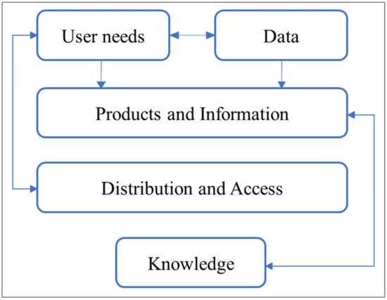
Beyond water quality data integration, translating this information to actionable knowledge and linking to stakeholder needs requires an iterative approach. GEO AquaWatch has developed such an approach based on an iterative development model used in the climate science community [4,5,6]. Briefly, the iterative development model enables research agendas to be created and modified by both scientists and stakeholders [5]. GEO AquaWatch defined the iterative development model into five stages: (1) defining end-user needs; (2) generating or obtaining data required to meet the needs; (3) aggregating or transforming the data into usable products and information; (4) distributing and enabling access to the products and information; and, finally, (5) translating the products and information into actionable knowledge through data assimilation of water quality derived from multiple space and time observations and platforms (Figure 2).

Figure 2. Schematic of the iterative steps GEO AquaWatch has developed to transform stakeholder needs into actionable knowledge.
2. Gaps and Challenges
Major challenges in data integration for water quality nowcasting and forecasting include data availability, interoperability, and reliability [7,8,9]. This is true for either fundamental trend analyses or more sophisticated model calibration and validation. Spatially and temporally sparse sampling, various methods, and protocols for any given parameter; missing ancillary data; incomplete or nonexistent metadata; and difficulty in accessing data portals all contribute to uncertainties [7] and lead to questions about the robustness of the data that do exist, such as: do we know the metadata provenance and trustworthiness? Do we know that proper quality controls were implemented, such as standard calibrations? Answers to these questions and others are critical for determining whether data are findable, accessible, interoperable, and repeatable [10], which are necessary to ensure, for example, that the science used in decision making is based on the best available and trusted data.
There is also a tendency for sampling programs to neglect exchanges and interactions across systems. For example, sampling only the receiving water body, such as an estuary or lake, but not the supplying rivers, streams, and groundwaters prevents consistent and comprehensive monitoring of water quality across the aquatic continuum and hinders the assessment and understanding of processes and pressures that operate across these interconnected systems. Evaluating such systems requires a better mechanistic understanding of the fluvial continuum from catchment to receiving water body. Evaluation must also include the preconditioned natural forces of change acting on systems to assess their resilience to absorb human-induced perturbations and extreme events for effective management, and to avoid tipping points [11]. This requires long term data streams that are consistent both spatially and temporally, which can be a challenge to find among government agencies. Data continuity and fidelity can also be hindered by short project funding cycles that have long term consequences.
Developing countries and remote locations often have minimal technical or institutional capacity to monitor water quality, manage the data, and report results [12]. This compounds the challenges of moving toward integrated water quality measures. Although international standards for water quality assessment (e.g., ISO—International Organization for Standardization) and data sharing, including metadata (e.g., FGDC—Federal Geographic Data Committee, ODC—Open Data Cube), are in place, no single standard is widely adopted and followed, thereby contributing to this challenge. All this can lead to large observational gaps of robust water quality data, needed to underpin water management decisions. One solution is to rely on innovative monitoring approaches, such as via the integration of satellite and drone remote sensing, citizen science, and models. A demonstration project in Bangladesh recently highlighted the impact of the use of satellite data by decision makers, where coordinated or centralized capabilities ensured users were trained for the use of satellite information and understood the limitations of different satellite products [13]. Global provision of water quality data often requires the integration of different types of data from different sources for use by different communities. Scattered initiatives provide databases and platforms but lack concrete sustainable support to maintain and widely use those infrastructures. A global platform will enable the community to access information globally, on which analysis can be carried out, decisions can be made, and policy questions can be answered.
3. Overview of Observational Methods and Platforms
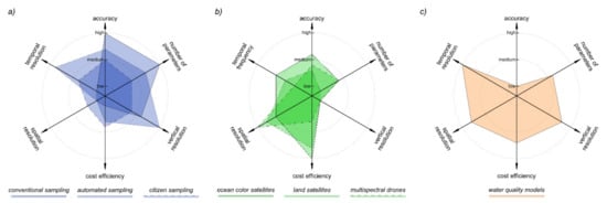
Measurements from different observing platforms, sensors, and data processing systems have different capabilities and characteristics, including differences in accuracy, number and type of parameters provided, temporal frequency, spatial coverage and resolution, and cost efficiency (Figure 3). The physical, chemical, or biogeochemical parameters of interest are manifold, but preference is increasingly given to those advanced as Essential Biodiversity, Climate or Water Variables [14,15,16]. In situ measurements often have high vertical (water column) resolution but low horizontal resolution, here defined as the capability to distinguish horizontal gradients, whereas, ocean color satellite data provide the converse. For example, in monitoring a river outflow or wastewater discharge, field sampling and sensors can provide data on many parameters at high frequency, potentially at high spatial resolution (in centimeters) and in both horizontal and vertical dimension, but low spatial coverage, whereas a satellite sensor (10 to 30 m) or drone (10 to 100 cm) may provide relevant information at sufficient spatial resolution and high spatial coverage, but miss variability in the vertical dimension. Another example may be a lake with a public drinking water intake. Here, an ocean color satellite may be useful for monitoring the entire lake, in situ sensor may benefit for high frequency sampling at the depth of the intake, discrete sampling enables event-driven responses, and models may be useful to understanding how upstream anthropogenic stressors may impact this resource and test scenarios to protect and restore water quality. If these sources are properly integrated, as proposed, many of the trade-offs and strengths are mitigated, enabling a more comprehensive toolbox for monitoring and interpreting water quality.

Figure 3. Schematic representation for the combination of (a) discrete, continuous, and citizen science measures combined with (b) remote sensing, and (c) modelling data. The combination provides complementary trade-offs of accuracy, number of parameters provided, spatial resolution, temporal frequency, and cost efficiency.
4. Data Integration
GEO AquaWatch, long-recognized as the Global Water Quality Initiative with an extensive global network, coordinates an integrated approach to community stakeholder involvement, and its Knowledge Hub is recognized as a trusted global water quality data and information center. Ongoing efforts by GEO AquaWatch working groups and short-term, cross-cutting focus group activities have yeilded metadata compilations, best practices for data providers, aquatic analysis ready data recommendations, and expanded community-wide information-sharing. Transformational water quality knowledge is delivered to GEO AquaWatch stakeholders via our website and social media accounts, a successful and sustaining webinar series, topical workshops, and Initiative meetings. Printed and electronic work products, such as whitepapers, publications, and data products, services, and tools compiled by our diverse subject matter experts, are easy-access, community-wide resources serving the gamut of water quality users. Leveraging GEO AquaWatch’s association with other national and international water quality organizations amplifies best-practice messaging and enables broader user input.
Stakeholder engagement in the delivery of fit-for-purpose, open source products, meeting user needs, is foundational to GEO AquaWatch’s portfolio of projects. A highlight is it’s namesake Google Earth Engine project for inland and coastal waters whichcompiles a reference database of biogeochemical, inherent, and apparent optical properties that is essential for calibration and validation of satellite products. AquaWatch features a self-guided user interface with a nimble API that delivers chunk-sized data streams to the Google Earth Engine Servers.
To effectively achieve integrated inland coastal water quality management, users ideally inform their decision-making through combination of evaluating acute conditions and general trends in satellite-derived and in situ data, and utilizing iterative models; but we recognize many users lack one or more of these “three pillars” of data assimiliation and must otherwise rely upon the best available information. The complexity of environmental systems, and the need for meaningful information to be provided to stakeholders, requires the integration of data collected from different and heterogeneous sources. GEO AquaWatch’s Real Earth Portal, expected to debut in 2022, synthesizes multi-platform water quality data from disparate sources and over broad temporal-spatial scales accessible through the GEO AquaWatch website. Many hydrodynamic and ecological models have evolved as relevant predictive tools, and it is essential to accurately calibrate and validate them with available observations to validly represent the reality. Data fusion (DF) techniques have been used to maximally extract consistent spatial and temporal description of variables within hydrodynamic-biological models, cohesively and systematically, to produce more robust and informative datasets. DF algorithms include the wavelength-based method [129], the Jointly Sparse Fusion of Images (J-SparseFI) [130] designed for pan-sharpening fusion, and other algorithms [131,132]. The effectiveness of DF has been demonstrated in improving spatio-temporal distributions of total organic carbon (TOC) [133], chlorophyll-a concentrations, and water transparency [134], and the prediction of harmful algal blooms [135].
NASA-promoted STAR-FM software (https://www.ars.usda.gov/research/software/download/?softwareid=432, accessed on July 2021), designed for the fusion of Landsat and MODIS images, is available for direct implementation of fusion techniques at the pixel level [136]. Spatial and spectral information of the pixel is correlated and combined to better characterize the single pixel.
To refine model parameters and better align prediction with measurements, Data Assimilation (DA) techniques have been used [137]. DA enables automated calibration of models, as well as enhancing forecast capabilities of biogeochemical and hydrological models and improving ecosystem state assessments [138]. Among the most common DA methods, the Ensemble Steady State Kalman Filter (EnSSKF) [139] and the Ensemble Kalman Filter (EnKF) [140] have been widely and successfully used to improve the prediction of lake temperature [122], suspended particulate matter concentrations [141], water levels and currents [142], and algae and algal bloom dynamics [143,144] through the integration of remotely sensed and in situ data. Data integration techniques are variable and site specific depending at the phenomena at hand scale, this is beyond the scope of this paper and thus not addressed.
To promote and facilitate the use of DA methodologies, pre-fabricated algorithms and toolkits have been developed and made available from several working groups. These toolkits include the Parallel Data Assimilation Framework (http://pdaf.awi.de/trac/wiki, accessed on July 2021), the Data Assimilation Research Testbed (DART, https://www.image.ucar.edu/DAReS/DART/, accessed on July 2021), and the OpenDA (https://www.openda.org/, accessed on July 2021), which was used successfully for the automatic calibration of a water level forecasting model [145] and current and salinity profiles [146] and for the improvement of forecast accuracy of a water quality model [147,148].
With such a reservoir of ready-to-apply methodologies, the effort in using these techniques and applying them to current modeling is reduced. Nevertheless, the accurate calibration of system models requires high resolution description of the model inputs. These are not always readily available for many environmental systems because of the limitations of current measurement technologies. This remains a major challenge for DA applications in water quality management that can be overcome utilizing DF techniques to integrate, fuse, and harmonize in situ, remote sensing, volunteer monitoring, and modeled data.
This entry is adapted from the peer-reviewed paper 10.3390/rs13152899
This entry is offline, you can click here to edit this entry!
