The Sustainable Groundwater Management Act (SGMA) and Central Valley Salinity Alternatives for Long-Term Sustainability (CVSALTS) initiatives have fundamentally changed future groundwater management in California [1,2]. Both embrace a holistic conceptual understanding of the resource and the interconnectedness of this resource with other vulnerable resources and the citizenry of the state. This shift in perspective also creates a need for a new suite of decision support tools to help stakeholders make cost effective, efficient, equitable, transparent and socially responsible decisions in the future.
- groundwater sustainability planning
- salinity management
- SGMA
- CVSALTS
- State of California
1. Genesis of SGMA and CVSALTS
The legal history of water development in California dates back to 1887 [1] with the passage of the Wright Act, followed by federal and state bills that provided funds to develop the dams to collect and store water and canal systems to convey the stored surface water to crop land where it was used for irrigation. While the majority of these laws targeted water rights and water allocation, fewer dealt with water quality and the groundwater resource was largely ignored. The recognition of groundwater subsidence due to over-pumping of groundwater in the San Joaquin Valley [2] between 1925 through the 1950s led to the importation of surface water from the pump stations located in the Sacramento–San Joaquin River Delta as a means of reversing damage to water conveyance infrastructure. However, this solution, applauded at the time, initiated an increase in soil salinization in the San Joaquin Basin and necessitated the introduction of environmental legislation—the Porter-Cologne Water Quality Control Act in 1969, and the California Environmental Quality Act in 1970—that recognized the San Joaquin River as an impaired waterbody [3][4]. This designation resulted in federal action by the US Environmental Protection Agency and the imposition of a Total Maximum Daily Load to sustain stakeholder beneficial uses of the San Joaquin River [5].
This conservative regulatory approach for water quality management led to the development of an alternative real-time stakeholder-involved real-time water quality management approach that relied upon 30-day running average salinity concentration objectives at compliance monitoring locations along the mainstem of the river and a commitment to real-time monitoring, stakeholder cooperation and coordination and investment in the cyberinfrastructure for real-time salinity forecasting [6]. The innovative regulatory approach undertaken for the San Joaquin Basin has been extended to the entire Central Valley of California through a more recent stakeholder-led salinity management initiative known as CVSALTS [7] that is developing strategies for salt management to maintain and sustain the beneficial use of water resources. The CVSALTS initiative is financed by entirely stakeholder voluntary contributions in recognition of the greater flexibility offered by local control and management of salinity in surface waters of the state [7].
Surface water and groundwater have long been managed by the federal and state water agencies as two entirely distinct and separate systems despite knowledge and evidence of their interaction and inter-relationship. Despite this conceptual and institutional oversight, the importation of water supply from the Sacramento–San Joaquin Delta to offset widespread land subsidence issues caused by groundwater over-pumping had successfully reversed a regional decline in groundwater storage until 1990. The severe drought in 1977 and the steady increase in urban demand did not impact the recovery of the groundwater system. Policy initiatives in 1991/1992 listed winter-run salmon in the San Joaquin River and the delta smelt (a small endemic fish that inhabits the freshwater–saltwater mixing zone in the delta) estuary. These policies changed the reservoir flow release patterns and restricted water export through the federal and state pumping plants during certain times of the year where the smelt were in danger of entrainment. In 1992, the Central Valley Improvement Act brought about a significant reallocation of developed water supply—800,000 acre-ft (987 million m3)—in support of environmental resource restoration including seasonally managed wetlands. Although, at the time, these initiatives to redress the imbalance between agricultural municipal and environmental beneficial uses were popular within the State of California, the long-term consequences of these actions are now being realized. Agricultural customers of federal water supply located south of the delta received a 100% water supply allocation in 1979—today, agricultural customer allocations are between 40% and 50% of the federal supply contracts. Prior to 1990 water shortages during severe drought could be alleviated by voluntary water transfers between agriculture and other urban, industrial and environmental beneficial uses. Water reallocations, delta pumping restrictions and land use changes to permamnent crops like vineyards and orchards has reduced the resiliency of the California water system.
California’s passage of the California Sustainable Groundwater Management Act (SGMA) in 2014 “is an example of how what occurs “overnight” can be a century in the making” [8][9]. California frequently now leads the nation in progressive legislation, as evidenced by sections of the state’s Porter-Cologne Water Quality Control Act being used as an exemplar for the Federal Clean Water Act. In 2006, the California legislature, under a Republican administration, took action on climate change—the first state to do so. Progressive as this action was, California remained the only state in the nation that had not adopted statewide mandates for groundwater regulation. Prior to the passage of SGMA, groundwater use was unregulated. Irrigators could augment existing surface water supply by drilling wells and accessing available groundwater. Groundwater is the sole source of irrigation water supply in some areas of the state, and is a backup water source in others, during prolonged droughts. The general perception among such landowners, called “overliers”, was that they had to right to extract as much water as they wanted [9]. See (a) below. The Supreme Court of California did not agree when, in 1903, it decreed that landowners share equally. See (b) below.
-
The issue in a case known as Katz v. Walkinshaw [9] was the assertion “ that each landowner owns absolutely the percolating waters in his hand, with the right to extract, sell and dispose of them as he chooses, regardless of the results to his neighbor, is part of the common law, and as such has been adopted in this State as the law of the land…”
-
The wording of the ruling by the presiding judge of the Supreme Court of California was as follows [9]: “Disputes between overlying landowners, concerning water for use on the land to which they have an equal right, in cases where the supply is insufficient for all, are to be settled by giving to each a fair and just proportion.” Between 1903 and 2014, there were several instances where there were opportunities to establish a statewide system to regulate groundwater use.
Between 1903 and 2014, the courts of California and the California legislature enacted policy that gave precedent to the establishment of a statewide system to regulate groundwater. In 1914, the enactment of the Water Commission Act created the agency that has become today’s State Water Resources Control Board. The first amendment of this act clarified that it only applied to surface water—it established a permit system for the appropriation of surface water rights. This was followed by several bills that mandated a series of groundwater investigations (Leahy 2016). In 1949, the adjudication of a groundwater basin in southern California, used by the cities of Pasadena and Alhamba, played a key role in establishing how to manage and allocate groundwater within a basin as well as a definition of safe yield: “the maximum quantity of water that can be continuously withdrawn from a groundwater basin without adverse effect” [10]. Legislation passed in 1953–54 set up the legal authority for a pump tax, the proceeds of which would only be used to acquire water for the replenishment of district groundwater supplies [9]. Frank Durkee, the State Director of Public Works at that time, wrote to Governor Earl Warren, urging the signature of the bill, stating the “proposal to levy assessments upon production of groundwater for the purpose of replenishing an overdraft on groundwater basins is a new principle in this State” [9][10].
The extended drought that began in 2007 and lasted through 2013 stimulated legislative actions dealing with water policy [9]. The future of irrigation and available drinking water was at stake. During this drought period, the availability of surface water for irrigation was severely limited and groundwater became a major source of irrigation water. Groundwater levels declined to historic lows, irrigation and drinking water wells went dry, land subsidence cracked and misaligned irrigation canals, and there was permanent depletion of storage space in the aquifers that underly California. The capability and capacity of canals to deliver surface water was reduced, as was the amount of groundwater available to buffer against future droughts. Continued use of groundwater greater than the rate of recharge was hastening the time when major reductions in irrigation would occur.
The conception of SGMA was a departure from previous groundwater management policies that relied on an understanding of safe yield and sustainable use of the resource from an extraction perspective. SGMA, instead, requires that attention be paid to the potential undesirable impacts of groundwater pumping, including chronic lowering of groundwater levels, reduction in groundwater storage, land subsidence, water quality degradation, and depletions of interconnected surface water systems (Figure 1) [11]. Seawater intrusion was the sixth undesirable result that is not applicable to groundwater basins in the San Joaquin Valley.
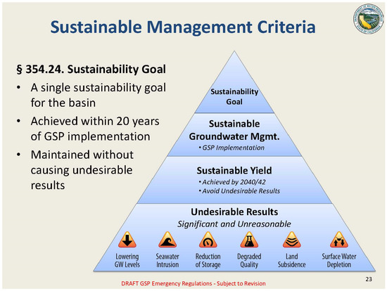
Figure 1. Sustainable management criteria applicable to Groundwater Sustainability Plan (GSP) development [8]—https://acwi.gov/swrr/p&p_library/May_2018/19_altare_sma_smc_swrr_may_2018.pdf (Accessed on 8 May 2021).
2. Implementing CVSALTS and SGMA Policies
The CVSALTS and SGMA initiatives both followed a Little Hoover Commission review of the CALFED Bay-Delta Program (2005) that recommended that all future water policy initiatives have direct stakeholder involvement [12]. The Little Hoover Commission is an independent California State oversight agency created in 1962 that investigates state government operations and promotes efficiency, economy and improved service through reports, recommendations and legislative proposals. The CALFED Bay-Delta Program [3] was formed as a joint state–federal entity in 1994 to coordinate water management activities primarily in the Sacramento–San Joaquin River Delta and develop appropriate science-based delta water quality standards. State and federal government agencies and stakeholders representing many local water agencies and environmental organizations signed an agreement on water quality titled, “Principles for Agreement on Bay—Delta Standards between the State of California and the Federal Government,” commonly referred to as the Bay-Delta Accord [3]. The accord was supposed to mark a critical milestone in California water history, resolving conflict and leading to greater future collaboration and joint planning activities.
Despite a considerable record of accomplishment, the commission determined that: (a) the current CALFED governance structure did not efficiently and meaningfully involve the broader public, provide the necessary transparency in the decision-making process or assertively resolve conflicts; and (b) the State of California should, in future, be obligated to provide more meaningful opportunities for the public and stakeholders to participate in the CALFED planning process to raise awareness, increase transparency, reduce conflicts and provide accountability [12]. The commission recognized an overall lack of public access to critical information for making planning decisions and the lack of an effective means of communication to ensure that the public was being heard [12].
The lessons drawn from the CALFED review and directed at the CVSALTS and SGMA initiatives were built upon the premise that conflict over water policy was more likely to be resolved locally and without resort to costly, long-term litigation when priority was given to local involvement at program onset. In the case of both CVSALTS and SGMA, the disaggregation of the river basin into distinct management zones (CVSALTS) or Groundwater Sustainability Agencies (SGMA) gave stakeholders significant control of the boundary setting for these areas and fostered the development of a coalition of interested parties from within the stakeholder group. The California Department of Water Resources provided initial maps of groundwater basins previously established for the reporting of groundwater conditions that provided an initial basin for GSA formulation and jurisdictional boundary delineation [13][14].
Under SGMA, the GSA was recognized as the primary entity responsible for achieving groundwater sustainability. The GSAs in basins ranked high- and medium-priority [13][14] were charged with early development and implementation of groundwater Sustainability Plans (GSPs) by January 2020. The formulation of the GSPs had to consider the interests of all beneficial uses and users of groundwater within their jurisdictions. The rationale for this prioritization was the recognition that the severity of the problems faced in these basins would require more time to resolve. The policy analysts responsible for the design of the SGMA allowed basins to adopt one or multiple GSPs but made sure in these instances that coordination agreements be designed and enacted between the GSAs named under each GSP. The SGMA legislation was expansive, providing GSAs with new authorities and decision support tools to manage the groundwater resource with the goal of meeting the primary objectives of the GSP. These new authorities included a mandate to conduct investigations, measure pumpage and impose limits on extraction, perform analysis to estimate the sustainable groundwater yield of each basin, recover the cost of groundwater management activities, and enforce the goals of the GSP filed with the California Department of Water Resources (CDWR) [15]. These authorities and their ability to survive legal challenges will be key to the long-term success of the program. In the interim, state planning and enforcement laws may need to be updated and amended to provide maximum flexibility and support to stakeholders encouraging the high level of cooperation and coordination necessary to develop equitable and long-lasting management solutions.
Osterling [16] suggested that there is a need to more clearly account for the sources of aquifer recharge to better assign groundwater sustainable yield. He posed that analysts recognize three sources of water: native, foreign and salvage. Native sources are those available to everyone, including rain, canal seepage from GSA sources, surface return flows from groundwater pumped within a GSA, inflow from watersheds above the valley floor often drained by ephemeral streams, and infiltration diverted from streams into subsiding subareas within the basin [16]. Foreign sources can include canal seepage from imported sources, subsurface drainage from adjacent basins or subsiding subareas and irrigation return flows from imported sources. Salvaged sources can include canal seepage from water supply conveyances to the GSA service areas and return flows from storm water. In California, all surface water sources are appropriated in that all water supply belongs to some entity, including seepage losses from appropriated water supplies. Water budgets developed by water agencies and other planning entities rarely recognize these distinctions.
Some entities [17] have criticized some of the regulatory deficiencies in the initial formulation of the SGMA conceptual framework, in particular, the boundaries of the groundwater basins based on CDWR Bulletin 118 that are used to define each GSA jurisdictional area. The authors note that by focusing only on alluvial basins and ignoring hard rock and volcanic aquifers and not defining the lower boundary of each groundwater basin (allowing local agencies to exclude lower lying brackish groundwater), this potentially allows use of these resources unconstrained by SGMA regulations [17]. The same authors note that approximately 40 percent of all wells exist in fractured hard rock and volcanic formations, which are relied upon for drinking water by rural communities and forest and aquatic ecosystems and that can provide recharge to alluvial groundwater aquifers downslope in the alluvial valley floor. Discounting these resources outside the SGMA jurisdictional boundaries can significantly underestimate the volume of the usable groundwater system. Similarly, with SGMA focusing initially on alluvial basins in medium- or high-priority groundwater basins, groundwater pumping in lower priority basins can still lead to undesirable results over time, such as the depletion of streamflow. Failure to recognize the interconnectedness of the surface and groundwater systems could have unanticipated secondary impacts.
The availability and promotion of analytical tools and accessible numerical models was recognized early in the SGMA process as being key to GSA formation and successful GSP development and implementation. A technical committee was formed to help develop guidelines for the use of these tools. Ideally, the models used would be in the public domain, providing transparency and the ability to replicate results of simulations of future scenario projections on the relevant sustainability indexes. The CDWR organized workshops to encourage use of their Central Valley regional C2VSIM model [18][19]. The model had been formulated at two levels of discretization to facilitate choice in the most appropriate level of hydrologic detail for use by GSAs [19], while recognizing that this is dictated by the fidelity of available data. A common template was developed by CDWR for the formulation of annual water balance spreadsheets in lieu of more complex numerical simulation models. This option was chosen by many GSAs who had not invested in groundwater simulation models as part of their groundwater resource management activities. Those GSAs that did have established models were permitted to continue their use and to further develop these models for the formulation of management scenarios and assessment of these scenarios relative to the implementation of the GSP. Data sets and output from these models were required to be accessible to analysts at CDWR and other interested stakeholders.
One important analysis made possible by these analytical tools is the assessment of groundwater recharge directly from precipitation, irrigation or surface water banking activities or indirectly through aquifer–stream inflow or deep well injection [17]. These tools can also help establish pumping setbacks from streams to protect surface water allocations of water and riparian habitats in instances where hydraulic gradients toward the rivers are reversed and streams are losing water to the local groundwater aquifer.
This entry is adapted from the peer-reviewed paper 10.3390/su13126658
References
- Oster, J.D.; Wichelns, D.E.W. Hilgard and the history of irrigation in the San Joaquin Valley: Stunning productivity, slowly undone by inadequate drainage. In Salinity and Drainage in San Joaquin Valley, California: Science, Technology, and Policy; Chang, A.C., Silva, D.B., Eds.; Springer: Dordrecht, The Netherlands, 2014; pp. 7–46.
- Larson, K.J.; Basagaoglu, H.; Marion, M.A. Prediction of optimal safe ground water yield and land subsidence in the LosBanos-Kettleman City area, California, using a calibrated numerical simulation model. J. Hydrol. 2001, 242, 79–102.
- CALFED Bay-Delta Program. Programmatic Record of Decision; Sacramento, CA, USA, 2000; Volume 1, p. 1. Available online: (accessed on 5 May 2021).
- Quinn, N.W.T. The San Joaquin Valley: Salinity and Drainage Problems and the Framework for a Response. In Salinity and Drainage in San Joaquin Valley, California: Science, Technology, and Policy, Global Issues in Water Policy 5; LBNL Topical Report—LBL-38498; Chang, A.C., Brawer Silva, D., Eds.; Springer: Dordrecht, The Netherlands, 2014.
- Quinn, N.W.T. Policy Innovation and Governance for Irrigation Sustainability in the Arid, Saline San Joaquin River Basin. Sustainability 2020, 12, 4733.
- California Department of Water Resources. California Data Exchange Center. Historical Sacramento and San Joaquin Valley Water Year Index. Available online: (accessed on 1 May 2021).
- CVSALTS. Salt Control Program. 2021. Available online: (accessed on 20 May 2021).
- State of California. 2014. The Sustainable Groundwater Management Act. Available online: (accessed on 16 December 2020).
- Leahy, T.C. Desperate Times Call for Sensible Measures: The Making of the California Sustainable Groundwater Management Act. Golden Gate Univ. Environ. Law J. 2015, 9, 4. Available online: (accessed on 5 May 2021).
- Chappelle, C.; Hanak, E.; Harter, T. Groundwater in California. Public Policy Institute of California: San Francisco, California. 2017. Available online: (accessed on 16 December 2020).
- California Department of Water Resources. Drought Information. Available online: (accessed on 10 June 2021).
- Little Hoover Commission. Still Imperiled, Still Important. The Little Hoover Commission’s Review of the CALFED Bay-Delta Program. Governor Arnold Schwarzenegger. “Governor’s Reorganization Plan 1: Reforming California’s Boards and Commissions.” Little Hoover Commission Public Hearing on Reorganization Plan 1. 26 January 2005. Available online: (accessed on 10 June 2021).
- California Department of Water Resources. California’s Groundwater Update 2020 (Draft). 2020. Available online: (accessed on 17 March 2021).
- California Department of Water Resources. Basin Prioritization. 2019. Available online: (accessed on 7 January 2021).
- Dunning, H.C. The Governor’s Commission: Success or Failure. 2005. Available online: (accessed on 5 March 2021).
- Osterling, E. 2020. Available online: (accessed on 10 June 2021).
- Thompson, B.; Rohde, M.M.; Howard, J.K.; Matsumoto, S.; Mind the Gaps: The Case for Truly Comprehensive Sustainable Groundwater Management. Water in the West. Stanford Digital Repository. 2021. Available online: (accessed on 1 May 2021).
- Dogrul, E.C.; Brush, C.F.; Kadir, T.N. Integrated Water Flow Model (IWFM), a Tool for Numerically Simulating Linked Groundwater, Surface Water and Land-Surface Hydrologic Processes; California Department of Water Resources: Sacramento, CA, USA, 2011.
- Brush, C.F.; Dogrul, E.C.; Kadir, T.N.; Chung, F.I. Applying C2VSIM, an Integrated Hydrologic Model of California’s Central Valley, to Assess Local and Regional Impacts of Conjunctive Use Projects; California Department of Water Resources: Sacramento, CA, USA, 2011.