1. Introduction
Ocean colour (OC) remote sensing provides information on in-water optical properties indicating the concentrations of water constituents such as chlorophyll-a. In optically shallow waters, depth and seafloor spectral reflectance may also be estimated using remotely sensed images. Information about near-surface, in-water optical properties, in the form of water quality maps, can provide advance warning of algal bloom development [
1] and potentially lead to early mitigation efforts to reduce health risks and financial losses. Bathymetric maps, derived from water depth estimates, can be used to produce or update navigational charts [
2], reducing the risk of ship groundings. Benthic habitat maps, inferred from seafloor spectral reflectance, can be used to track changes in the distribution of seafloor habitats [
3,
4]. However, extracting ocean colour products such as chlorophyll-a, water depth, and bottom types from remotely sensed images is difficult because, over blue ocean waters, only ~10% of the total signal that reaches the TOA (Top of Atmosphere) typically comes from within the water column [
5]. In addition to the radiation leaving the water column (
Lw), the TOA radiance measured by satellite sensors includes contributions from scattering and absorption in the atmosphere and reflection at the sea surface [
6]. It is important to estimate and account for the contribution from these other sources in order to estimate
Lw, which is readily normalized by the total downwelling irradiance just above the sea surface to yield the remote sensing reflectance (
Rrs).
Atmospheric effects are removed through atmospheric correction (AC) [
7], but residual errors in AC can introduce large uncertainties in
Rrs estimates, resulting in erroneous retrieval of OC products such as apparent optical properties [
8]. In open ocean waters, where phytoplankton governs the optical regime, it can be conveniently assumed that there is no water-leaving radiance in the near-infrared (NIR) region, such that any measured TOA radiance in this spectral band is attributed to atmospheric path radiance and reflectance from the water surface. While this assumption is valid for open-ocean waters, in shallow or optically complex waters that are, in general, characterized by a combination of constituents, such as phytoplankton, coloured dissolved organic matters, and suspended particulate matters,
Rrs(NIR) may be significantly greater than zero because of bottom reflectance (which can come from highly reflective near-surface vegetation such as kelp and seagrasses) and backscattering by suspended materials [
9]. This can lead to over-correction of atmospheric and surface reflectance effects, leading to underestimation and even negative
Lw estimates within the shorter wavelengths used to derive OC products [
9,
10]. To account for the non-negligible
Rrs(NIR), algorithms that work for Case 2 waters have been developed (e.g., [
10,
11,
12]) and tested (e.g., [
13,
14]). With these efforts, it is now possible to retrieve
Lw over coastal waters. However, the low spatial resolution of traditional ocean colour sensors inhibits the detection of detailed features that are not easily discernible in coarse-resolution satellite images. The recent availability of higher-resolution satellite sensors, e.g., Landsat 8 Operational Land Imager (OLI) and Sentinel-2 Multispectral Instrument (MSI), with adequate spectral and radiometric characteristics for ocean colour applications, has the potential to greatly improve coastal ocean colour applications, including water quality [
15,
16], bathymetry, and seafloor habitat mapping [
17].
Optimizing the utility of the OLI sensor for aquatic science and applications requires validating
Rrs products to better understand their potential and limitations. A few recent studies have started investigating the quality of OLI-derived
Rrs for coastal applications. For example, Pahlevan et al. [
15] used the AC scheme in SeaDAS software package to determine the best Landsat 8 band combinations that can minimize error in
Rrs retrieval over different coastal water types at select AERONET-Ocean Colour (OC) sites. Using newly computed calibration gains, they revealed that OLI-derived
Rrs estimates are as good as those from other ocean colour sensors. Likewise, the work of Franz et al. (2015) [
18] illustrated the potential of OLI data for water-related studies. By employing the AC process in the SeaDAS Level-2 processing algorithm (l2gen), they assessed the quality of OLI-derived
Rrs and subsequently retrieved the chlorophyll-a concentration over the Chesapeake Bay, USA. In agreement with Pahlevan et al. (2017a) [
15], they found that with a precise AC procedure, the high radiometric quality and improved imaging capabilities of OLI hold great promise for satellite-based coastal monitoring. Doxani et al. (2018) [
19] tested a wide range of AC algorithms over different land cover types, highlighting the strengths and limitations of each algorithm. More recently, Wei et al. (2018) [
20] also assessed four AC algorithms with a focus over water bodies, revealing that the NIR-short-wave infrared (SWIR) approach implemented in SeaDAS produced the most robust
Rrs estimates from Landsat 8. However, none of these studies examined the effects of environmental variables on the
Rrs retrieval accuracy of different AC algorithms.
With the increase in usage of OC products among the science community, and the need for robust Rrsproducts, it is important to understand the potential of AC algorithms. Most of the ocean colour community has for years been using water-based AC methods for a wide range of applications from coastal to inland waters, so it is important that the effects of relevant environmental variables on the Rrs retrieval accuracy of these AC algorithms is examined. Such knowledge may assist in the choice of AC algorithm for a given set of environmental conditions, and/or improved Rrs retrieval under a wider range of conditions. Equally important is that other users interested in studying inland waters (e.g., biogeochemists, aquatic biologists) fully understand the accuracy of generic AC processors, in particular the land surface reflectance product, which is commonly used.
Here, we pursued an approach similar to Pahlevan et al. (2017a) [
15], but expanded it by evaluating the performances of four different AC algorithms to determine which method produces the most robust
Rrs products in shallow coastal waters. Also, like Doxani et al. (2018) [
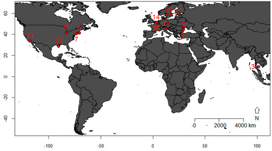
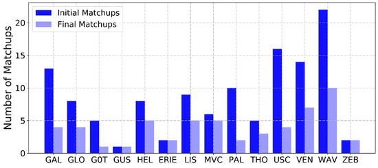
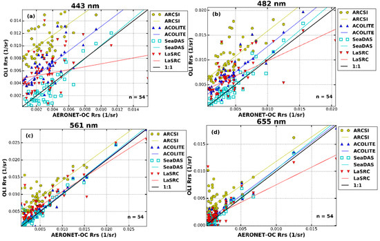
19], we tested both land-based and water-based algorithms at multiple sites, but covered more sites over a longer time period to better capture space-time dynamics related to water optical properties. Using 54 in-situ measurements from 14 AERONET-OC sites, we (1) tested the following algorithms for atmospheric correction of Landsat 8 images: (a) Atmospheric and Radiometric Correction of Satellite Imagery (ARCSI) [
21], (b) the Atmospheric Correction for OLI ‘lite’ (ACOLITE) [
22], (c) SeaDAS [
8], and (d) the United States Geological Survey’s standard land-based AC used to produce the Landsat 8 Surface Reflectance (LSR) Climate Data Record (Landsat CDR), herein referred to as LaSRC [
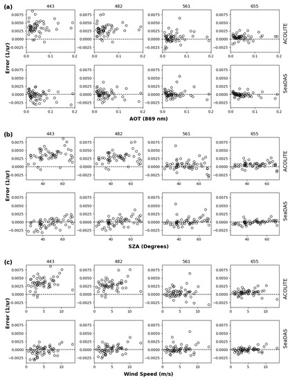
23]; (2) analysed the differences in spectral bands between satellite and in-situ measurements; and (3) examined the effects of three key environmental variables on the
Rrs retrieval accuracy of water-based AC algorithms. To our knowledge, this is the first inter-comparison exercise that tested AC algorithms using representative data from many coastal sites with varying atmospheric conditions and optical properties, combining the three approaches mentioned above in a single study.


