Rain is a natural process that attenuates the propagating signal at microwave and millimeter-wave frequencies. Therefore, it is necessary to mitigate rain attenuation to ensure the quality of microwave and millimeter-wave links. To this end, dynamic attenuation mitigation methods are implemented alongside attenuation prediction models that can predict the projected attenuation of the links. Studies on rain attenuation are used in geographically distributed locations to analyze and develop a rain attenuation model applicable over a wide frequency range, particularly radio frequencies over approximately 30 GHz for 5G and beyond network applications.
- ITU-R model
- rain attenuation
- millimeter-wave
- rain attenuation time series
1. Preliminaries
1.1. Rain Attenuation Factors
1.2. Rainfall Rate Data Collection Procedures
1.2.1. Available Databases
1.2.2. Experimental Setup
1.2.3. Rain Rate Data Generation: Synthetic Technique and Logged Data
1.2.4. Rain Rate Prediction from Spatial Interpolation Techniques
| Ref. | Estimation Techniques |
|---|---|
| [26] | The proposed technique generates rain attenuation time series using storm speeds from 1 to 12 m/s in a two-layered rain structure model. Also, temperature, altitude, and height are used as per the geographic location. |
| [27] | A(t)=a0⋅e2dAG/βa√⋅W(t)+dAG⋅va/βa⋅t1+dAG⋅a0∫t0e2dAG/βa√⋅W(s)+dAG⋅va/βa⋅sds where a0:0–0.5 dB, W(t): Wiener process, βa, va: gamma distribution parameters, dAG: Dynamic parameter β of the Maseng-Bakken model. |
| [28] | It proposed an enhanced technique to generate rain attenuation time series where precise rain rates are not available at global scale using ITU-R model. The technique uses mean and standard deviation of rain rate either from NOAA [29] and ITU-R model [30] and the output of Gaussian noise through a low-pass filter (LPF: k/p+β, cut-off frequency fc: 0.2 MHz) into a non-linear memoryless device, where Aoffset is the calibration factor, Aoffset:exp(m+σQ−1(P0/100)) and Q: zero-mean, unit variance Gaussian probability density function. |
| [31] | A(x0)=kA∫LA0RαA(x0+Δx0,ξ)dξ+kB∫LBLARαB(x0,ξ)dξ where LA and LB are the radio path lengths, Δx0 is the shift due to the presence of layer B, x0=v⋅t, and v is the average storm speed (typically 10 m/s). |
| [32] | A(t0)=1cosθ[∫d0+SAd0kAR(l)αAdl+∫d0+SA+SBd0+SAkB3.134αBR(l)αBdl], where θ:link elevation angle, (αA, kA), (αB, kB): power-law coefficients that converts the rain rate into specific attenuation for layers A and B, respectively, and R: rain rate along the link. |
| [33] | A copula is a multivariate distribution function expressed by marginally uniform random unit interval variables and it can avoid dependence index like in log-normal distribution. The procedure is: ρ=sin(πτ2)→ zero mean Gaussian random variables correlated matrix→normal CDF→desired random variable→inverse CDF of the desired distribution. |
| [34] | The procedure is: RG=e−β⋅|τ|→[βEMB,βgamma]→H(z)=1−e−2βTs√1−z−1e−βTs, where Ts: sampling time, and βEMB and βgamma are 12.3d−0.95×10⁻⁴ and 6.9d−0.6×10⁻⁴, respectively. |
| [35] | The procedure is: ak=1N∑N−1j=0Mje−i2πNkj=I(Mj)→ak=hkI(cG)−−−−−−−√×ek→Mj=I−1(ak),[hk=0.5], where M(t): Gaussian process, ℑ and I−1 are direct and inverse Fourier transforms, respectively. |
| [36] | Compute the stochastic differential equation: dA(t)=μ4da(μ2λA(t)−A2(t)+μ2).dt+daμ3λ−−−−√A(t)dW(t), where da=2βaS2aλμ3, where μ and γ are found by fitting to experimental first order statistics of rain attenuation, βa and Sa are the parameters of the diffusion coefficient of the M-B model. |
| [37] | Compute:P(ti)=1−P0,i→zi=Tz(ri)→findMz(d)→GaussianPDF→ρj(τ)→Hi(z), where P0,i is the possibility of rain in the ith station, ri represents a nonlinear transformation Tz, and ρj is the temporal autocorrelation function of rain attenuation for ith link. |
| Ref. | Technique or Resolution |
|---|---|
| [5] | Analyzed millimeter-wave and showed that the ITU-R predicted rainfall rate of region P is up to 0.01% of time (agrees → 99.99% of time and disagrees → 0.01% of time). |
| [22] | This multi-source blending technique to estimate high-resolution space-time rainfall scales to develop and merge remote sensing, conventional spatial interpolation, atmospheric re-analysis of rainfall, and multi-source blending techniques. |
| [38] | It presented gauged-based data re-analysis at a resolution of 0.5∘×0.5∘. |
| [39] | In GSMaP-NRT, it analyzed the satellite, microwave-infrared, and near real time weather dataset to compare better predictability presented resolution about 0.01∘×0.01∘. |
| [40] | ECMWF: 1.125∘×1.125∘ |
| [41] | It proposed the spatial and the temporal correlation functions to determine rainfall rate. |
| Ref. | EPL or PCF | Parameter Settings | Remarks |
|---|---|---|---|
| [2] | r=1/{1+0.03(100P)βlm}⧫ | Method: Practical measurement; Frequency band: 7–38 GHz; Path length: 58 km; and rain rates were collected over 1-min time interval. | The correction factor depends on β; link length; and p% of rain |
| [3] | rrad(t)=Arad,d(t)/γRd | Method: Simulation Frequency: 22 and 38 GHz Path lengths: 2, 5, 10 and 20 km | The correction factor only depends on the Arad,d(t), and γR(t). |
| [42] | r=11+L2636R(P)−6.2 | Method: Practical measurement Rain rate: 5-min point at 11 GHz frequency; 42.5 km long radio link with R>10mm/h | The correction factor depends on the radio link length and rain rate. |
| [43] | r=1.08L−0.5108 (7 GHz for 0.01% of the time) |
Method: Practical virtual link; Link length: 1–10 km; Time exceedance: 0.01%; Frequency 7 GHz | The reduction function depends only on the total path length. Estimation: Exponential curve fitting |
| [44] | deff=11+d/d0⋅d | Method: Practical setup; Site: S. Paulo, Brazil; Season: Dry season; Frequency: 15 GHz (4 links) and 18 GHz (2 links) with vertical and horizontal polarizations; Path lengths: 7.5–43 km; Duration: 1–2 year | The correction factor depends only on the rain rate exceedance of p% of the time. Estimation: exponential curve fitting |
| [45] | r(R0.01,L)=L×(−R0.011+ζ(L)×R0.01)▲ | ITU-R database; Site: 8 countries; Path lengths: 1.3–58 km; Frequency: 11.5–39 GHz; Rain rates (0.1%): 18–105mm/h | The PCF depends on rain rate exceedance %p of time and link length. Estimation: curve fitting |
| [46] | r=3.6435Rp−0.377 | Method: Practical setup; Link length: 2.29 km; Rain Gauge: Tipping rain bucket (0.254 mm accuracy); Frequency: 28.75 GHz | The correction factor depends only on the rain rate exceedance of the %p of the time. Estimation: curve fitting. |
| [47] | r(R0.01,d)=d/[1+{d/2.6379R0.010.21}] | Practical setup; Link length: unavailable; Rain Gauge: Tipping, Frequency: 15 GHz, Availability: 99.95%; Duration: 4 years; Rain rate: R (0.1 to 0.001) | The correction factor depends only on the rain rate exceedance of the %p of the time and LOS link length. Estimation: exponential curve fitting |
| [48] | r=1.303ς1+LD♣ | Model: empirical model, based on the point of inflexion (POI) | The correction factor depends only on the slant path length and the rain cell diameter. |
| [49] | r=A/(kRαTXLslant) | Method: MultiEXCELL rain simulation. Calculation: rain attenuation is calculated via the numerical approach. Rain field size: 1 km × 1 km to 250 km × 250 km | The correction factor depends on calculated attenuation, specific attenuation conversion coefficients, ‘measured’ rain rate at the transmitter end, and the LOS link length. |
| [50] | r=1[0.477L0.633R0.073α0.01%f0.123−10.579(1−e−0.024L)] | (1) Can be used worldwide; (2) frequency band: 5–100 GHz; (3) Maximum path length is 60 km | The correction factor depends on the frequency (GHz), specific attenuation coefficient (α), and link length (L). |
| [51] | r=⎧⎩⎨⎪⎪Necosθ(hR−hStanθ)Necosθ(10.056+0.012R)R<R0R≥R0 | The number of effective cells (Ne) is calculated after analyzing ITU-R DBSG3 database. | To define the rain cell, it needs to know the cell (R0) boundary rain rate. |
| [52] | r=⎧⎩⎨⎪⎪⎪⎪⎪⎪⎪⎪[11.77d0.77R−0.050.01][10.477d0.633R0.0730.01f0.123]2f≤40GHzf>40GHz | It was based on the measured attenuation of smaller than 1 km terrestrial link and frequency 26/38 GHz. | It concluded that the distance factor is inconsistent for a link length smaller than 1 km. |
| Ref. | Technique or Resolution | Remarks |
|---|---|---|
| [53] | E=1nCountry∑i=1415Wi∣∣∣log(RiDBSG3RiS−B)∣∣∣ | This test was used to re-analysis based rain rate and the rain rate provided by the ITU-R DBSG3 database. |
| [54] | ER0.01=E2ψ+E2ϕ+ΔR0.012−−−−−−−−−−−−−−−√ where E2ψ=(∂R0.01∂ψ)2σ2ψ and E2ϕ=(∂R0.01∂ϕ)2σ2ϕ. |
The model was developed and verified using DBGS3 along with CHIRPS rainfall (ψ), and TPW (ϕ) in the ERA-Interim Reanalysis database. Authors have not compared with measured data and the precise calculation of rain rate R0.01 showed lower accuracy (uncertainty is about 14%). |
1.3. Distance Correction
1.4. Frequency and Polarization
2. Rain Attenuation Models: Terrestrial Links
-
Empiricalmodel: The model is based on experimental data observations rather than input-output relationships that can be mathematically described. The model is then classified as an empirical category.
-
Physical model: The physical model is based on some of the similarities between the rain attenuation model’s formulation and the physical structure of rain events.
-
Statistical model: This approach is based on statistical weather and infrastructural data analysis, and the final model is built as a result of regression analysis in most cases.
-
Fade slope model: In the fade slope model, the slope of attenuation from the rain attenuation versus time data was developed with a particular experimental setup. Later, these data were used to predict rain attenuation.
-
Optimization-based model: In this type of model, the input parameters of some of the other factors that affect the rain attenuation are developed through optimization (e.g., minimum error value) process.
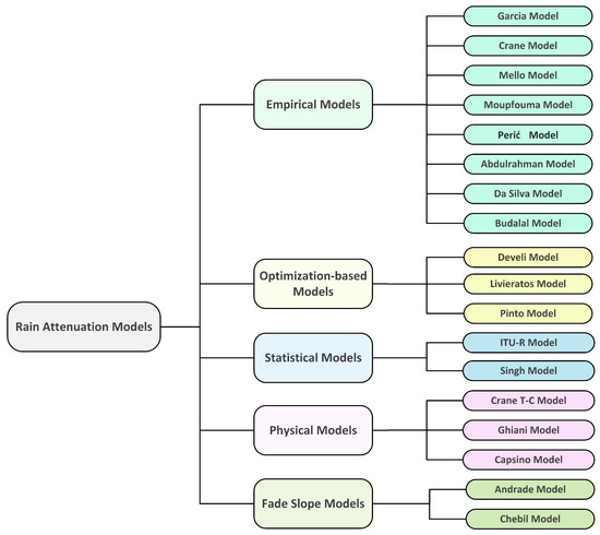
2.1. Empirical Models
2.1.1. Moupfouma Model
2.1.2. Budalal Model
2.1.3. Perić Model
2.1.4. Garcia Model
2.1.5. Da Silva/Unified Model
2.1.6. Mello Model
2.1.7. Abdulrahman Model
2.1.8. Crane Model
2.2. Physical Models
2.2.1. Crane Two-Component (T-C) Model
2.2.2. Ghiani Model
2.2.3. Excell/Capsoni Model
2.3. Statistical Models
2.3.1. ITU-R Model
2.3.2. Singh Model
2.4. Fade Slope Models
2.4.1. Andrade Model
2.4.2. Chebil Model
2.5. Optimization-Based Models
2.5.1. Develi Model
2.5.2. Livieratos Model
2.5.3. Pinto Model
This entry is adapted from the peer-reviewed paper 10.3390/s21041207