Great Chilean Earthquake (1960) is the most powerful earthquake ever recorded, occurring on May 22, 1960, with a magnitude of 9.5–9.6. Originating off the coast of southern Chile, it caused widespread destruction, significant loss of life, and a massive tsunami that affected countries across the Pacific Ocean. The event led to advancements in seismology, tsunami warning systems, and disaster preparedness.
- 1960 Chile earthquake
- Valdivia earthquake
- Megathrust earthquake
1. Introduction
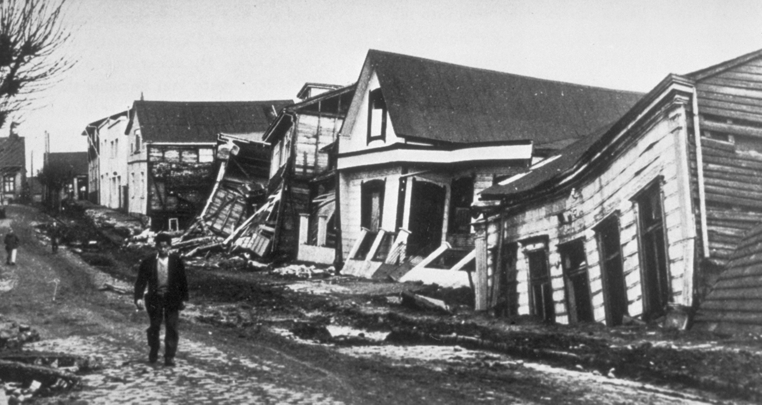
On May 22, 1960, southern Chile experienced the most powerful earthquake ever recorded, registering a magnitude of 9.5–9.6 on the moment magnitude scale. Known as the Great Chilean Earthquake or the Valdivia Earthquake, this catastrophic event resulted from the subduction of the Nazca Plate beneath the South American Plate. The earthquake caused widespread destruction across Chile and generated a massive tsunami that affected countries across the Pacific Ocean [1][2].
Source: By Pierre St. Amand - NGDC Natural Hazards Slides with Captions Header, Public Domain, https://commons.wikimedia.org/w/index.php?curid=630576
2. Tectonic Setting and Causes
Chile is situated along the Pacific Ring of Fire, a region characterized by active tectonic plate boundaries and frequent seismic activity. The Nazca Plate, an oceanic plate, is subducting beneath the continental South American Plate at an average rate of 7–9 centimeters per year. This convergent plate boundary is responsible for the formation of the Andes Mountains and is a hotspot for megathrust earthquakes.
The 1960 earthquake was the result of a sudden release of accumulated stress along a 1,000-kilometer segment of the subduction zone, causing a massive rupture. The earthquake's epicenter was near the town of Lumaco, approximately 570 kilometers south of Santiago, with the city of Valdivia experiencing the most severe damage.
3. Seismic Characteristics
-
Date and Time: May 22, 1960, at 15:11 local time (19:11 UTC)
-
Magnitude: 9.5–9.6 Mw
-
Depth: Approximately 25 kilometers
-
Duration: Approximately 10 minutes
-
Type: Megathrust earthquake
-
Affected Area: Extensive damage from Talca to Chiloé Island
The earthquake was preceded by a series of foreshocks, the most significant being a magnitude 8.1 quake on May 21, which caused considerable damage in the city of Concepción. The mainshock on May 22 released an estimated energy equivalent to 20,000 Hiroshima atomic bombs, making it the most energetic earthquake ever instrumentally recorded.
4. Impact in Chile
Human Casualties and Displacement
The earthquake and subsequent tsunami had devastating effects on the Chilean population:
-
Deaths: Estimates range from 1,000 to 6,000 fatalities
-
Injuries: Approximately 3,000 people injured
-
Homeless: Around 2 million people were left homeless
The cities of Valdivia, Puerto Montt, and Concepción suffered extensive damage, with many buildings collapsing and infrastructure destroyed. In Valdivia, approximately 40% of buildings were destroyed, and the city's port facilities were rendered inoperable.
Economic Damage
The economic impact of the earthquake was substantial:
-
Estimated Losses: Between $400 million and $800 million in 1960 USD (equivalent to over $4 billion today)
-
Infrastructure: Destruction of roads, bridges, ports, and communication lines
-
Agriculture: Flooding and soil liquefaction damaged farmlands
The earthquake also caused significant changes in the landscape, including land subsidence and uplift, which altered river courses and created new lakes. For instance, the Riñihuazo phenomenon occurred when landslides blocked the outflow of Riñihue Lake, threatening downstream communities with catastrophic flooding. Emergency efforts successfully mitigated this risk by manually creating channels to drain the lake.
5. Tsunami and Global Effects
The earthquake generated a massive tsunami that had far-reaching impacts across the Pacific Ocean:
-
Chile: Coastal towns were inundated by waves up to 25 meters (82 feet) high, causing widespread destruction.
-
Hawaii: The tsunami reached Hilo approximately 15 hours after the earthquake, with waves up to 10.7 meters (35 feet) high, resulting in 61 deaths and significant property damage.
-
Japan: The tsunami arrived about 22 hours later, causing 138 deaths and destroying over 1,600 homes, particularly in the Sanriku region.
-
Philippines: At least 21 people died due to the tsunami.
-
New Zealand: The tsunami was observed at more than 120 locations, with wave heights ranging from 1 to 5 meters, leading to the first major tsunami evacuation in the country's history.
-
Other Areas: Tsunami effects were observed in Australia, the Aleutian Islands, and as far as California, where two deaths were reported.
The tsunami's extensive reach highlighted the need for a coordinated international warning system, leading to the establishment of the Pacific Tsunami Warning Center in 1965.
5. Scientific and Engineering Advances
The 1960 earthquake provided valuable data for the scientific community:
-
Seismology: Enhanced understanding of megathrust earthquakes and subduction zones.
-
Tsunami Research: Improved modeling of tsunami generation and propagation.
-
Earthquake Engineering: Led to the development of stricter building codes and construction practices in seismic zones.
Chilean engineer Arturo Arias made significant contributions to earthquake engineering, including the development of the Arias Intensity measure, which quantifies the strength of ground motion during earthquakes. His work has been instrumental in designing structures to withstand seismic forces.
7. Emergency Response and Recovery
The Chilean government and international community responded promptly to the disaster:
-
Relief Efforts: Deployment of military and medical aid, including field hospitals and temporary shelters.
-
International Aid: Assistance from countries such as the United States and organizations like the Red Cross.
-
Infrastructure Rebuilding: Reconstruction of roads, bridges, and public buildings with improved seismic resilience.
The disaster also prompted the Chilean government to invest in long-term disaster preparedness and risk reduction strategies, including the establishment of national agencies dedicated to emergency management.
References
- "Chile earthquake of 1960 | Causes, Effects, & Facts." Encyclopedia Britannica. https://www.britannica.com/event/Chile-earthquake-of-1960.
- "Valdivia Earthquake Strikes Chile." National Geographic Education. https://education.nationalgeographic.org/resource/valdivia-earthquake-strikes-chile/