Your browser does not fully support modern features. Please upgrade for a smoother experience.
Please note this is an old version of this entry, which may differ significantly from the current revision.
Subjects:
Water Resources
Groundwater is an important natural resource in the North China Plain (NCP) with high economic benefits and social significance. It fulfills 60% of drinking and 70% of irrigation water requirements. Groundwater becomes unsafe for human consumption due to pollution caused by inappropriate waste disposal, industrial discharges, and agricultural runoff.
- groundwater depletion
- degradation
- cropping system
- North China Plain
1. Introduction
The degradation and depletion of groundwater worldwide have become serious environmental problems that endanger ecosystem health and water security [1]. Rapid urbanization, industrial needs, and intensive agricultural irrigation all lead to unsustainable extraction rates, which lower water tables and deteriorate aquifers [2]. Over pumping for agricultural and urban water supply has resulted in significant drops in groundwater levels in the Middle East, the United States, China, and the Indian subcontinent regions [3]. Climate change exacerbates the problem by changing precipitation patterns and affecting aquifers’ natural replenishment too [4]. Groundwater becomes unsafe for human consumption due to pollution caused by inappropriate waste disposal, industrial discharges, and agricultural runoff [5].
According to World Health Organization (WHO) estimation due to pollution problems, almost 2 billion people worldwide do not have access to clean drinking water [6]. Recharging aquifers, encouraging water use efficiency, and implementing effective irrigation techniques are all examples of initiatives that are essential to sustainable groundwater management [7]. Reducing pollution and over-extraction is largely dependent on the establishment of strong monitoring programs, legal frameworks, and public awareness initiatives [8]. The necessity of sustainable groundwater management is emphasized by the 2030 Agenda for Sustainable Development, particularly Goal 6 (Clean Water and Sanitation), to protect the supply of clean water for present and future generations [9].
China is experiencing an over-extraction of groundwater from aquifers due to the country’s fast economic expansion, urbanization, and intensification of agriculture. Due to this, groundwater levels have decreased, land has begun to sink, and the quality of the water has gotten worse [10]. The overuse of water for agriculture in China is a major cause of groundwater depletion. Large-scale irrigation projects and the production of crops that require a lot of water have resulted in unsustainable rates of extraction, especially in northern areas like the North China Plain [11]. Furthermore, a serious problem is the deterioration of groundwater quality, which is made unsafe for agricultural and drinking uses by untreated sewage, industrial discharges, and agricultural runoff [12,13]. Statistics of water consumption in 2020 are presented in Figure 1 [14].
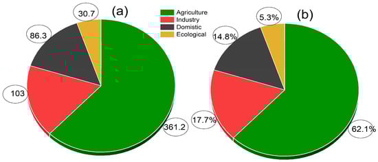
Figure 1. China’s water uses in 2020 by types, (a) in billion cubic meters and (b) in percentage [14].
2. Overview of North China Plain (NCP)
The NCP is located in the eastern coastal region of China (34°46–40°25′ N and 112°30′–119°30′ E). The Yanshan mountain border from the north, south, and west is the Tailhang, Dabie, and Tianmu mountains, while from the east is the Yellow Sea boundary. The region is widely extended to Henan, Hebei, and Shandong provinces and merges with the Yangtze River in the north of Jiangsu and Anhui. Beijing is the national capital, Tianjin is a hub of industries, and Shandong is the base of petroleum. Thus, the region is the main economic and political center of the county [15,16].
The region has subtropical monsoon climatic conditions. Seasonally, dry cold air emanating from central Asian regions prevails from December to February, resulting in a temperature drop below −0 °C. The mean temperature during summer, particularly June to July, ranges between 25° and 28 °C, which are considered the hottest months. Thus, the region is classified into four distinct seasons based on changing weather year-round, including spring (dry), summer (hot), autumn (windy), and winter (cold). The annual precipitation is highly variable (300–1000 mm) throughout the NCP, with a mean range from <600 mm and about 70% rainfalls during the maize growing season from June to September [17]. Low rainfall makes the plain prone to drought. Generally, there is no balance between mean annual rainfall and evapotranspiration. The long-term climatic scenario in the North China Plain is presented in Figure 2.
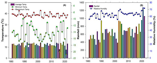
Figure 2. Long-term climatic scenario in the North China Plain [18]. The maximum, minimum and average temperature (A), rainfall and relativity humidity (B) in the region.
In the case of soil characteristics of NCP, it is mainly fluvo-aquic; other types include meadow and coastal solonchak, saline meadow, saline swamp, sandy, and cinnamon. Illite is the dominant layer silicate mineral; smectite, kaolinite, and chlorite are subdominant. In most counties, the saline and sodic soils are severe problems for agricultural sustainability, where soil properties are affected by monsoon rainfall events, groundwater chemistry, and its depth, as well as surface water and variation in topographical characteristics. The soils of most areas have low clay content [19,20]; however, it is suitable for most field crops.
The double cropping of winter wheat–summer maize (WW-SM) rotation is the dominant pattern throughout the regions, covering >80%. Hence, this region meets >60% of the national wheat and >30% of the corn demand of the country, and >50% of peanuts are also produced here. All these features make this region crucially self-sufficient in food [21]. The geographical boundary of NCP in China is shown in Figure 3.
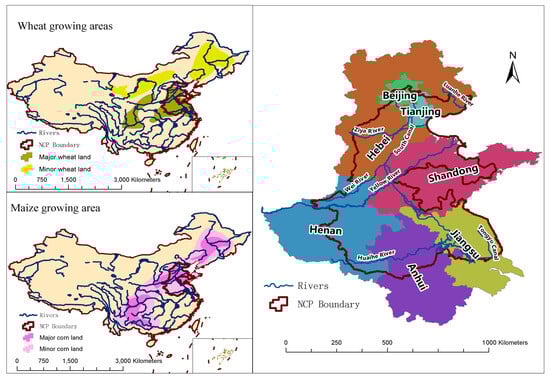
Figure 3. Major wheat and maize growing areas and geographical boundary of NCP in China. The map was prepared in ArcGIS version 10.2.2 using data source from Agricultural Handbook No.664 of the United States Department of Agriculture (USDA).
In agriculture, modern technology, mechanization, and fertilization greatly help boost crop productivity. Increased incomes dramatically changed the living standards of rural peoples, poverty levels dropped sharply, and extreme poverty was eradicated. For example, a significant increase in wheat yield (0.7 Mg ha−1) was observed in 2009 [22]. Nonetheless, with that success, the side effects became visible within a short period in terms of groundwater decline, and N pollution in the water bodies and air due to systematic change in crop cultivation such as overuse of irrigation and fertilizers [23,24]. The excessive water use in crop production system increased pressure on water-resources throughout the region and excessive chemical fertilizer application deteriorated water quality [25]. Approximately 15% of food production in China could reduce due to water shortage caused by continuous groundwater decline [26]. These concerns of groundwater depletion and N contamination have existed for a long time. NO3− has been found in shallow to deep aquifers [27]. A recent study [28] revealed that N contamination was dominant with an excessive limit of water quality standards in farmlands due to the use of manures. Groundwater in villages is unsafe, and the consumption of water contaminated by high NO3− levels could cause several diseases in rural people [29].
In response to escalating environmental concerns, the government has taken proactive measures through legislative actions. For instance, a prohibition on groundwater pumping has been enforced along the fourth ring road of Beijing. Additionally, efforts have been made to advocate for eco-friendly policies, such as the implementation of the ‘land fallow system’. This system encourages leaving soil unsown in regions heavily impacted by groundwater depletion and pollution, particularly during the winter season. In 2014, a document for water resources conservation was first proposed, and then NCP was selected as one of the leading ecologically degraded and NO3-contaminated zones. After that, researchers focused highly on the NCP, and many experiments were conducted. Research is ongoing to overcome the problems [30,31].
3. Environmental Challenges
Currently, the entire NCP region is experiencing serious groundwater decline and NO3− pollution in water bodies due to the intensive double cropping pattern of WW-SM under the farmer management practices. There are >7.6 million tubewells throughout the region. The farmers of this region normally apply 6–7 times the irrigation in the WW-SM rotations by each time pumping >90 mm; thus, annual groundwater abstraction reaches >600 mm ha−1 [32], and (N) fertilizer application exceeds the crop utilization capacity of >250 kg ha−1 yr−1 [33]. Approximately >400 mm of irrigation water is applied to the winter wheat crop. Consequently, enormous water pumping caused a >1 m yr−1 groundwater decline [32] and overuse of N-contaminated groundwater via the NO3− leaching pathway [34]. The historically measured groundwater water table drop is shown in Figure 4 and the present ecosystem scenario of the region is precisely illustrated in Figure 5.
3.1. Groundwater Depletion
Groundwater is an important natural resource in the NCP with high economic benefits and social significance. It consists of four grouped layers of the aquifer. The first, second, third, and fourth aquifers are about 40 m, 130 m, 220 m, and 350 m deep, respectively. The specific yield of aquifers varies between 0.04 and 0.25 m, depending on their rock material. Since the 1970s, frequent excessive water pumping has caused scarcity of underground water reservoirs. Consequently, the first aquifer is already depleted, and now the second aquifer is going to be depleted because water pumping from the ground for crop purposes is quicker than it can replenish. The annual natural water refilling is low due to low rainfall intensity. The amount of water from rainfall cannot meet the recharge requirements. Therefore, the plain is the world’s fastest depleting groundwater region [11,35]. The situation can be even tighter in the near future, and the agricultural system may fluctuate badly. For example, the water table is continuously decreasing every year in the counties along with the Beijing capital side, and the fast development of urban areas will further increase the demand for water and reduce its availability. Xiao et al. [36] reported that there is no balance between the water overdraft of a prevalent cropping pattern and groundwater recharge. Luo et al. [37] conducted a field experiment on different cropping patterns for 4 years and reported that WW-SM caused the highest groundwater level drop and had the lowest <128 mm recharge amount.
Recently, Liang et al. [38] evaluated various cropping patterns and reported that the primary reason for groundwater decline was winter wheat. Wheat crop water consumption was about 300–450 mm yr−1, which substantially exceeds the average annual rainfall of 280 mm yr−1 [39]. On the other hand, surface water resources are insufficient; groundwater is the only strong source of irrigation [36], which accounts for 70% of the total water supply [40] and low rainfall could only meet 25–40% of crop water requirements [41].
Many studies have reported groundwater level drops and their causes by using different methodologies and techniques. Some researchers have used Geographical Information Systems (GISs) to analyze water availability and geographic distribution. The GIS and its tools are widely used in agriculture. The management of crop yield, optimization of rotations, soil mapping, and analysis of groundwater vulnerability, storage potential, and flow are greatly visualized and estimated by using GIS for future strategies. There are several advantages of GIS, such as covering a wide area in the research, which is easier than manually measuring. For example, groundwater storage variation monitoring in mountain and arid regions is not only challenging but also time-consuming through relying on the observation of wells because the well observations are generally limited [42] and satellite missions such as the Gravity Recovery and Climate Experiment (GRACE) provide monthly changes in terrestrial water storage [43]. Feng et al. [44] used GRACE satellite data to estimate groundwater storage changes in the NCP during 2002–2014 and reported that groundwater is being depleted faster. Yin et al. [45] also estimated groundwater drops and reported that groundwater was severely depleted, particularly in the Beijing, Tianjin, and Hebei provinces. In a recent study, Kumar et al. [46] stated that NCP has an unsustainable groundwater level as compared to the south of China. Lin et al. [47] identified the hotspots within the Yellow River basin, where the water declination rate was relatively higher in the west and east areas of the river. This description indicates that groundwater security is quite important. Table 1 shows the different studies and estimations about groundwater decline from 2001 to the present. The table contains local and regional level outcomes of experimental work conducted in the NCP. The average groundwater decline value as 1.18 m yr−1 from surveyed publications. The historically measured groundwater water table drop from July 1974 to June 2014 and its forecasted trend are shown in Figure 4 [48].
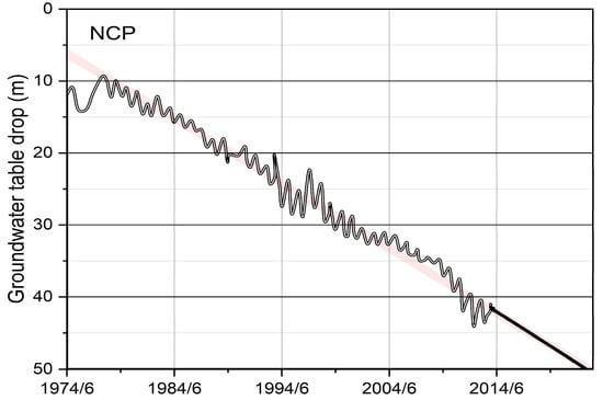
Figure 4. Historical groundwater water table drop in NCP [48].
3.2. Groundwater Degradation
Environmental pollution is another serious problem of NCP. Heavy reliance on N fertilizers to boost grain productivity compared to the past created tough challenges for both agriculture and environmental sectors. It has been identified that agricultural farming causes more pollution than any other source [49,50]. A recent study showed that fertilizer use increased by >30% in the past few years [51]. Intensive use of commercially available chemical fertilizers is hazardous to the ecosystem (Figure 5) as they are produced by blending with a range of trace metals [52]. A typical plant can uptake half of the applied N only, while the remaining enters water bodies via a deep drain in the process of leaching and is lost to the atmosphere through volatilization and denitrification pathways [53,54]. In the NCP, the normal N fertilizer application rate reaches >600 kg ha−1 yr−1, exceeding up to >250 kg N ha−1 yr−1 compared to the crop N requirement (CNR) for optimum growth and development [33]. The exceeded N is generally lost and consequently contaminates the environment since N, in the form of NO3−, is highly water-soluble and mobile. Therefore, it moves and displaces freely with water through most types of soils. Approximately a 10–20% N loss takes place via leaching from the crop production system. Many researchers characterized the agriculture of the region as low-N-efficient. The N fertilizer efficiency is often <25% to 20% because farmers apply N through the broadcasting method, which is an inefficient method as compared to modern techniques. Ju et al. [55] reported that annual N application at the rate of >550 kg ha−1 did not increase yield and led to two times greater NO3− losses. Cao et al. [56] observed a peak of N fluxes at >180 kg N ha−1, and it was observed immediately after fertilization. Wang et al. [57] performed a meta-analysis, covering >150 field measurements for N loss from an agricultural system. They stated that NCP is more widely affected by N contamination than any other region. Proper farming practices that keep the soil moisture and pH at the optimum levels would help decrease different forms of N losses such as NO− and NO3− [58], and Li et al. [59] examined cropping systems and found that the NO3− flux was closely related to irrigation levels and N fertilizer application rates; <40 kg ha−1 NO3− leaching was observed when the N rate was <180 kg ha−1, and maximum >50 kg ha−1 NO3− leaching was noticed when the N rate was >400 kg ha−1 in combination with >300 mm irrigation. Technically, field water transports the excessive NO3− to deep groundwater; thus, it is the dominant pathway of NO3− deposition in groundwater [60]. The leached NO3− deteriorates both shallow and deep water with an estimate of >20 mg L−1. Recently, Wang et al. [28] compared different land use types, including farmland, forestland, and areas that were under natural vegetation. They found that NO3− contamination in water reached up to 50 mg L−1 in farmlands because of manure use being >223 kg N ha−1 yr−1. This is an excessive limit of NO3− in the water following the water quality standard index and the World Health Organization’s (WHO) criteria for safe water [6]. The consumption of such highly degraded water for drinking could cause the conversion of hemoglobin to methemoglobin, which depletes oxygen levels in the blood, thyroid gland enlargement, congenital disabilities, stomach, colorectal, bladder, and breast cancer, and hypertension. Water that is contaminated with >10 mg NO3− L−1 is the most dangerous for the health of children. Furthermore, the complete details about how NO3-s adversely impact health are well elaborated in the specific literature of [29], where they specifically studied the N in relation to human health issues (Table 1).
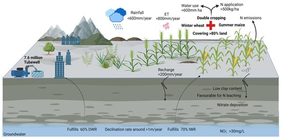
Table 1. Groundwater (GW) depletion rate and NO3−1 contamination in groundwater reported by different researchers.
| GW Depletion | Location | NO3− Level | Location | References |
|---|---|---|---|---|
| 0.10 m yr−1 | Hebei to Tianjin | 2.18 mg L−1 | Eastern Taihang Mountains | [67,68] |
| 3.83 m yr−1 | Zhangjiakou | 178.7 mg L−1 | Hutuo River Valley Plain | [69,70] |
| 1.30 m yr−1 | Luancheng | 10.34 mg L−1 | Baiyangdian Lake Area | [71,72] |
| 0.33 m yr−1 | Hebei | 1.840 mg L−1 | Beijing Urban Sides | [38,73] |
| 1.70 m yr−1 | Shijiazhuang | 70.40 mg L−1 | Rural Beijing | [74,75] |
| 0.59 m yr−1 | Beijing and Tianjin | 124.4 mg L−1 | Hutuo River Plain | [37,76] |
| 1.00 m yr−1 | WR | 6.230 mg L−1 | Pinggu District | [77,78] |
| 1.60 m yr−1 | Hebei | 50.00 mg L−1 | WR | [28,79] |
| 1.10 m yr−1 | Luancheng | 184.6 mg L−1 | Shandong | [66,80] |
| 1.14 m yr−1 | Taihang Mountain | 47.70 mg L−1 | Catchment Areas of Hutuo | [81,82] |
| 1.15 m yr−1 | Hufu Plain | 134.8 mg L−1 | Baiyang Lake Area | [83,84] |
| 1.25 m yr−1 | WR | 31.60 mg L−1 | Beiyishui Watershed | [30,85] |
| 1.50 m yr−1 | Luancheng | 10.00 mg L−1 | Luoyang Basin Area | [86,87] |
| 1.00 m yr−1 | WR | 29.60 mg L−1 | Yellow River Sides | [87,88] |
| 1.07 m yr−1 | Taihang Mountains | 13.40 mg L−1 | WR | [89,90] |
| 0.71 m yr−1 | Piedmont Plain | 56.80 mg L−1 | Tangshan | [91,92] |
| 0.80 m yr−1 | Xian | 9.370 mg L−1 | Hebei | [93,94] |
| 1.21 m yr−1 | Hebei | 13.80 mg L−1 | Beijing | [95,96] |
| 1.00 m yr−1 | WR | 10.00 mg L−1 | Huantai | [97,98] |
| 0.45 m yr−1 | Hebei | 20.00 mg L−1 | Quzhou | [99,100] |
| 0.87 m yr−1 | Ningjin | 20.00 mg L−1 | Shijiazhuang | [101,102] |
| 1.10 m yr−1 | Shijiazhuang | 45.00 mg L−1 | Beijing and Surroundings | [103,104] |
Note: Hence, the average value of groundwater depletion is calculated as 1.18 m yr−1 from the surveyed publications and the average value of NO3− contamination in the groundwater is calculated as 48.67 L−1. The classification of NO3− content levels: 0–3 mg L−1 (clean), 3–6 mg L−1 (lightly polluted), 6–10 mg L−1 (polluted), and 10 or >10 mg L−1 (severely polluted) [105]. The WR indicates that the study reported on the whole region. GW is groundwater.
4. Mitigation Options
There are several mitigation options that could be taken in the NCP to overcome groundwater depletion and reduce the risk of water pollution. These include water saving and change in crop type, the ban on cereals, reduced and soil test-based N application, use of slow-release coated urea, and optimum irrigation to minimize the risk of N transport in the groundwater through deep drainage. All these options fall in the category of a cropping system. Therefore, a change in the cropping system has high potential [38] and has been found to be the most commonly used approach in the literature related to NCP published by researchers. Other options, including artificial recharge by utilizing urban and industrial wastewater, could be significant as well. However, brackish water should not be used on high land [5]. It is somewhat suitable only for lowlands as a substitution for freshwater [105]. In Figure 6, some broad options are enlisted where sub-components are classified with their potential level.
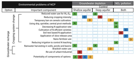
4.1. Cropping System Change Option
The cropping system is a broad idea, where selections of crop type and cultivation practices are critically important. A cropping system should be environment-friendly and socio-economically viable.
4.1.1. Groundwater Neutral Cropping Pattern
The current cropping pattern of winter wheat–summer maize is unsustainable. Therefore, other options like a monoculture of spring maize or adopting any alternative cropping pattern could be eco-friendly. The annual crop water requirement of spring maize would not be >350–551 mm [108]. The plots of three harvests in a two-year pattern of winter wheat, summer maize, and spring maize or one harvest in one year demonstrated significant potential to reduce water and N consumption, produce maximum grain yield, and maintain groundwater balance [38]. Meng et al. [22] studied various crop rotations in long-term field experiments from 2004 to 2010 and reported that although >70 mm of water can be saved by optimizing the irrigation schedule in a double cropping pattern as compared to the conventionally managed field, the annual groundwater utilization of 250 mm was still high, where >70% water was consumed only by the wheat crop. At the same time, the triple cropping pattern and monoculture saved 35–61% water with a minor decrease in wheat grain yield. These cropping patterns would decrease 94–190 mm of annual groundwater demand.
In addition, the 59–72% N rate can also be reduced by adapting alternative patterns against conventional double cropping patterns. Yang et al. [66] evaluated five cropping patterns in which many crop species were included. The results showed that WW-SM rotation had the highest evapotranspiration (ET) rate of 734 mm yr−1 compared to any other cropping pattern. Therefore, they observed a maximum groundwater decline of 1.1 m yr−1 and low WUE and a minimum groundwater decline of 0.4 m yr−1 with high WUE from sweet potato–cotton–sweet potato–winter wheat–summer maize in a 4-year cycle. Many other researchers also evaluated WW-SM in comparison with alternative cropping patterns and suggested optimizing cropping patterns. Recommendations include winter wheat–early maize–early maize–fallow [109], alfalfa–winter wheat [57], peanut–winter wheat–summer maize [39], winter wheat monoculture [110], sweet potato–cotton–sweet potato–winter wheat–summer maize [66], and sole summer maize [111]. Furthermore, Table 2 shows some recommendations with supporting comments for the development of groundwater water-neutral cropping patterns. However, replacing a double cropping system of winter wheat–summer maize with a new cropping system could cause grain production decline in the region.
Table 2. Some recommendations for groundwater water conservation under the cropping pattern change option.
| Recommendations | Supporting Comments for Recommendations | References |
|---|---|---|
| WW-SM-SPM | Water conserved up to 284 mm | [22] |
| WW-SM-SPM | Lowered groundwater decline by 0.33 m yr−1 | [38] |
| SP-C-SP-WW-SM | The system showed less groundwater decline by 0.4 m yr−1 | [66] |
| WW-SM-SPM-SPM | N fertilizer can be reduced up to 30–50% in the system | [112] |
| WW-EM-EM-F | Increased water saving of 2322 × 106 m3 | [113] |
| SM-monoculture | Showed 30% low water overdraft | [111] |
| 2Y3MS1 | Balanced groundwater overdraft | [114] |
| Ww-SMOpt | Saves 62% of groundwater use (minimum irrigated) | [115] |
| Catch crops | Decreased 23.6% drainage and 32.8% NO3− leaching | [116] |
| Mixing switchgrass | Lowered water table drop by 0.4 m yr−1 | [75] |
| SPM × SOY | Increased land utilization rate by >40% | [117] |
| Alfalfa-WW | Reduced water consumption by 70.5% and NO3− leaching by 35% | [57] |
| WW-SM-SPM-SPM | Resulted in less groundwater drop of 0.07 m yr−1 | [37] |
| SS-WW | Mitigate groundwater decline through fewer evaporations | [118] |
| Early maize only | It had 190 mm less groundwater overdraft | [112] |
| WW-SM-F-SPM | Revealed low water overdraft by 150 mm yr−1 only | [113] |
| SPM-monoculture | Showed 31% high grain yield via minimum water use | [119] |
| PN-WW-SM | The system had 19% low evapotranspiration | [39] |
| CT-WF-ESM | Exhibited 33.7% higher water utilization | [120] |
| WWOpt-no-till | Reduced risk of groundwater drop | [110] |
| WW-watermelon | Consumed low water and N fertilizer | [121] |
| SPM-monoculture | Showed lowest, 139 mm yr−1, water consumption | [122] |
Note: Hence, the change in cropping pattern is recommended by rejecting the conventional cropping pattern of WW-SM based on surveyed publications. WW: Winter wheat, SM: Summer maize, EM: Early maize, F: Fallow, PN: Peanut, SOY: Soybean, SPM: Spring maize, SS-WW: Sweet sorghum–Winter wheat, CWF-ESM: Cotton–Wheat fallow–Early summer maize, SP-C-SP-WW-SM: Sweet potato–Cotton–Sweet potato–Winter wheat–Summer maize, CT: Cotton, WF-ESM: Winter fallow–Early summer maize.
4.1.2. Groundwater-Friendly Farming Practices
Many studies evaluated farming practices to better understand the impacts of field management on groundwater. Along with the change in the cropping pattern, different farming techniques should also be considered, such as root-zone watering, low N applications, and deficit irrigation [53], and limited water supply to the conventional WW-SM could reduce 15 to 35% water consumption by increasing 10 to 30% WUE [123]. Xu et al. [124] revealed that improved farming practices and technology have shown good results by reducing >60% of N and >50% of water loss by sloping croplands; together, 20% of crop productivity also improved. Still, there are several challenges for sustainable water and nitrogen use. A breakthrough is required in a series of agricultural technologies, including efficient crop production, mechanization, and standardization, which can help to achieve sustainable yield goals by protecting and restoring natural resources. This would all be possible through enhancing WUE and NUEs, which are associated with farming practices. Advance farming practices include the use of new drip, sprinkler, central pivoted, and subsurface irrigation technology, as well as the application of slow-release N and Nano fertilizers. Nowadays, easy-to-use remote sensors have also been invented for farmers’ use, so they can analyze CWR very quickly by themselves without going to laboratories and finding specialists, but such technology is not successfully transferred to the farmers.
Furthermore, there is a lack of awareness among the farmer community due to education factors. If farmers apply water via a drip and nitrogen after testing soil moisture and N concentration and follow the integrated agronomical strategy, then excessive use of water and N could be reduced in the region. For example, Meng et al. [22] saved 19% water and two times more NUE via soil testing than farmer practice in the WW-SM field and also obtained optimum grain yield. Sun et al. [122] achieved 5.4 kg ha−1 mm−1 greater WUE as compared to the conventionally managed field of WW-SM rotations. Similarly, Chen et al. [125] prevented 85.2% NO3− leaching through an analysis. There are several studies concerning farming practices; Yan et al. [126] conducted a field experiment on the maize crop from a plant density aspect and suggested 7.5 plants m−2 as optimum for enhanced crop N utilization. Li et al. [127] performed an experiment on irrigation methods and concluded that raining of irrigation (RI) to the crop via a sprinkler was the best practice compared to conventional border irrigation (BI). They also found that the RI system increased by 64.8% WUE. Yan et al. [126] suggested that wide precision planting enhanced both WUE and NUE. Hu et al. [128] recommended the use of slow-release coated urea for maximum N recovery.
These findings are pioneering and would significantly help to improve farming practices for groundwater sustainability. A list of recommendations is presented in Table 3 for developing groundwater-neutral farming practices and controlling NO3− transport in the groundwater.
Table 3. Some recommendations for groundwater water conservation under optimized farming practices.
| Recommendations | Supporting Comments for Recommendations | References |
|---|---|---|
| <200 kg N ha−1 | Because >200 kg N ha−1 caused N leaching from WWSM | [24] |
| Larger spike wheat | Larger spike wheat showed N efficiency > 10% | [25] |
| Straw incorporation | Significant inhibited annual N loss of about 31% | [58] |
| 75 mm watering | From jointing to booting stages in WW showed excellent result | [69] |
| 394 mm water yr−1 | Showed as optimum for WW-SM rotations | [75] |
| 330 kg N ha−1 yr−1 | Reduced N losses by 34% from WW-SM field | [39] |
| Soil test-based N | 85.2% NO3− leaching can be reduced from the wheat field | [125] |
| 7.5 plants m−2 | Showed higher NUE of maize than plant density, 9.0 m−2 | [126] |
| Subsoiling tillage (ST) | Water storage capacity increased in 2 m soil layer | [129] |
| ETWatch-UZF-MODFLOW | Improved the groundwater balance for shallow aquifers | [130] |
| Drip irrigation | Proven as efficient irrigation method in water-scarce area | [46] |
| BI→RI | RI showed 64.8% WUE compared to conventional BI | [131] |
| FP → OPT | Significantly decreased N loss by 28.6% in WW-SM | [132] |
| 43 kg N ha−1 | Concluded as the optimum ecological dose for maize | [133] |
| Sprinkler irrigation | Lowered water consumption and improved WUE (17.7%) | [134] |
| N via fertigation | Reduced risk of NO3− contamination in groundwater | [135] |
| Wide planting | Enhanced WUE and NUE compared to traditional method | [59] |
| CTS → NTS | NTS significantly decreased NO3− leaching losses | [136] |
| Use of coated urea | Slow-release coated urea increased maximum N recovery | [128] |
| Conservatory tillage | 30.1% WUE was improved compared to conventional tillage | [137] |
| 5-day-delay sowing | ET was decreased by 3.5 mm day−1 for wheat | [138] |
| Mulching in maize | Reduced soil evaporation loss by 40–50 mm yr−1 | [139] |
Note: Hence, the optimized farming practices are recommended by rejecting conventional cultivation practices in light of surveyed publications. BI: Border irrigation, RI: Raining irrigation, FP: Farmer practice, OPT: Optimized practice, CTS: Conventional-tillage system, NTS: No-tillage system.
4.2. Groundwater Recharge Option
Integrated use of options such as a change in the cropping system plus aquifer charge should be preferred to conserve natural resources because the shallow aquifer is already depleted, and the deep aquifer is under stress in the region. Artificial recharge of aquifers is a great technique for groundwater recovery and improving water availability. It can help to solve many problems associated with water scarcity, including low crop productivity issues, land subsidence, intrusion of seawater, particularly in the Tianjin coastal area, and ecosystem damage. The artificial recharge of groundwater is becoming a necessary measure over time because natural recharge is low in the region. For instance, Cao et al. [140] and Min et al. [141] conducted research on groundwater recharge in the NCP and found that the mean groundwater recharge was 130 and 200 mm yr−1 during the period between 1993 and 2008 and 1976 and 2013, respectively. In a recent study, Min et al. [142] reported the groundwater recharge rate as 92.80 mm yr−1 in the central plain areas. There is a significant difference in groundwater recharge from area to area in the region. Approximately 89 mm yr−1 of groundwater is recharged through rainfall contribution [143] and >40 mm yr−1 comes from irrigation [144]. Generally, natural groundwater recharge in the region is influenced by some biotic and abiotic factors, i.e., the vegetation type, precipitation, soil properties, especially texture, and amount of irrigation to the crop. Every year, the increase in the cultivated area increases the annual rate of ET and thus reduces recharge [134]. The magnitude of natural recharge depends on precipitation events. The recharge of <100 mm yr−1 and <200 mm yr−1 could be classified as rainfall representation of 18% and 30%, respectively. Scientifically, precipitation undergoes various evaporative effects before recharging the groundwater [140]. In this research, groundwater recharge has been calculated from the surveyed publications with an average value of 121.96 mm yr−1 (Table 4). This recharge amount of water is insufficient, considering figures of groundwater obstruction in the region. Therefore, artificial groundwater should be considered. It has been estimated that >40 b m3 of water could be stored underground via artificial recharge [145]. After a deep search of the literature, it was found that a few government projects are running for groundwater recharge, including the Chaobai river (spreading basin), Yongding river (trench + well injection), and Tanggu section (deep well injection). The first two schemes are being used to enhance groundwater storage. As a result, groundwater has risen to a satisfactory level, and the decline has slowed as compared to the historical background of selected areas. At present, the new South-to-North Water Transfer (SNWTP) project is being highly appreciated. It is called the “Silver bullet” and can restore the groundwater when it will be fully operational. This project has been designed to deliver 20 b m3 yr−1 to address the water shortage issue of the region [146]. This kind of government effort would be a key to recovering groundwater storage, but the government should also take some low-cost steps for local-level groundwater recharge methods, such as commonly rural peoples harvesting rainfall water in wells, ponds, ditches, and basins for crop production, which is greatly helping to restore and sustain the groundwater. Encouraging such human activities through technology and finance will provide better results in conserving groundwater reservoirs. The digging of ditches and small basins inside the crop land and on the wasteland could save an ample amount of water, which will serve as recharge sources after pumping. On the other hand, urban and industrial wastewater should be well utilized after primary or secondary treatment. It should be regarded as a valuable water resource for not only groundwater recharge but also for farming use since the amount of urban and industrial wastewater is very high. For example, the Hai river basin generates about 10,000 mm3 yr−1. The proper wastewater harvesting and recycling will also carry surface drainage waters, including rainfall, which will be additionally advantageous to solve the problems related to wastewater management. It would minimize the risk of pollution caused by the wastewater discharge. However, there are some institutional and technical constraints to effectively harvest wastewater and reuse it [114]. A better strategy and joint work of ministries such as Water and land and resources, Agriculture, Environmental protection, Housing, and Urban and rural development would be useful to overcome technical matters since the subject of groundwater management is widely fragmented among these ministries. Some literature showed that urban wastewater was utilized in a few severe water shortage areas for crops and groundwater recharge without adequate measures, which resulted in the deterioration of underground water through NO3− contamination [79].
Strategies such as rainwater harvesting and artificial recharge for groundwater show possibilities in mitigating groundwater depletion and deterioration [147]. Rainwater is collected and stored for a variety of uses, which is known as rainwater harvesting. This technique offers an alternative water source that can lessen the need for groundwater for household and agricultural requirements by collecting rainfall runoff from rooftops or other surfaces [148]. This is an economical and ecologically sustainable method that may be applied at many levels, ranging from individual dwellings to more extensive community-wide initiatives [147]. Intentionally accelerating the natural process of water penetration into the earth is known as artificial recharge of groundwater. Spreading grounds, injection wells, and recharge basins are involved in some of the techniques that can be used to accomplish this [149]. These methods successfully recharge aquifers and mitigate the detrimental consequences of excessive groundwater extraction by facilitating the percolation of water into the soil [150]. Groundwater quality is enhanced and groundwater levels are restored via both artificial recharge and rainfall harvesting. When rainwater percolates through the soil during artificial recharge, pollutants are naturally filtered away, and it is usually devoid of the toxins commonly present in surface water. Thus, these approaches provide a dual advantage by raising the amount of accessible groundwater and improving its overall quality [149,151].
Table 4. Groundwater water recharge reported by different researchers.
| Recharge | Area | Reference | Recharge | Area | Reference |
|---|---|---|---|---|---|
| 102.0 mm yr−1 | WR | [65] | 177.0 mm yr−1 | Lacustrine plain sites | [152] |
| 65.00 mm yr−1 | WR | [99] | 90.00 mm yr−1 | WR | [144] |
| 120.0 mm yr−1 | Central plain | [140] | 108.0 mm yr−1 | Liaocheng city | [153] |
| 200.0 mm yr−1 | WR | [141] | 85.80 mm yr−1 | Luancheng | [154] |
| 92.80 mm yr−1 | Central plain | [142] | 168.0 mm yr−1 | Weishan district | [155] |
| 130.0 mm yr−1 | WR | [156] | 126.8 mm yr−1 | Shijiazhuang | [157] |
| 188.0 mm yr−1 | Cangzhou | [158] | 63.80 mm yr−1 | Tongzhou | [159] |
| 180.0 mm yr−1 | Piedmont plain | [160] | 138.7 mm yr−1 | Hebei | [161] |
| 150.0 mm yr−1 | Taihang mountains | [133] | 124.3 mm yr−1 | Hengshui | [162] |
| 134.0 mm yr−1 | Luancheng | [163] | 175.0 mm yr−1 | Hebei | [164] |
Note: Hence, the average groundwater recharge value is calculated as 121.96 mm yr−1 from the surveyed publications. The WR indicates that the study reported on the whole region.
This entry is adapted from the peer-reviewed paper 10.3390/w16020354
This entry is offline, you can click here to edit this entry!