The rapid technological advancements in communication media, such as GPS technology, augmented reality (AR), ubiquitous computing, and smart devices, have brought significant changes to how people perceive both physical and virtual spaces, as well as the concept of gaming. The emergence of the hybrid space and AR has laid new foundations for game design, and the process of designing LBGs has become participatory through open-access tools and platforms, allowing users and players to create their own games.
2. Implementation of LBG Prototypes
Taleblazer, ARIS, Locatify, and Actionbound are ideal platforms for students, offering comprehensive experiences and active learning opportunities. Taleblazer is suitable for educational games; ARIS is ideal for storytelling games; and Locatify and Actionbound are great for treasure hunts and guided walks. These platforms require low or no-code writing, making them ideal for users with little or no programming knowledge. They also support remixing games, allowing users to create non-standardized experiences. ARIS and Taleblazer are free, with the first one providing its source code for user contributions, while Locatify and Actionbound are free to use with limitations.
2.1. TaleBlazer
2.1.1. The Main Features of TaleBlazer
Taleblazer is a free augmented reality (AR) game platform that allows players to play both indoors and outdoors. It is a low-code platform designed for users who are novices in programming since it uses visual block programming. Taleblazer uses global positioning system (GPS) technology to locate players’ positions and allow them to interact with virtual content. Taleblazer’s hybrid experiences can be used for storytelling, education, social participation, and entertainment.
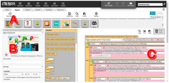
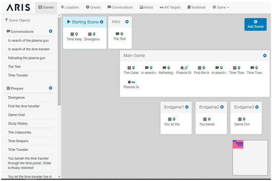
To create a game, users need to define locations in the real world and add elements such as agents representing characters or objects. Taleblazer consists of five software components: An online game editor, a game repository, a server for multiplayer games (currently under development (2023)), a mobile application, and an analytics server for game statistics. As shown in Figure 1, the platform comprises six tabs: map, agents, player, world, settings, and beacons.
Figure 1. Taleblazer web editor, (A) Agents with their names from left to right: What’s next? Mayor, Final Decision etc. (B) Name field: defining the name of the selected agent with current value "Result of "Smart Bin Management System”, (C) Sample code segment composed of blocks: the text in Greek refers to identifiers’ names and values assigned to them.
The game’s map section defines the real-world location of the game, which can be based on Google Maps or a map of the current location. Agents are visible as icons on the map, and the game can be played without an Internet connection. Multiple regions or the same region with different agents can be defined multiple times, as can internal regions.
The game designer can define characteristics and actions for the player, world, and agents. These can be visible or invisible, depending on the designer’s choice. Players can interact with agents in five ways: GPS proximity; selecting the agent’s image on the map; “Heads Up” that uses the compass and GPS readings of the device to show nearby agents as markers overlaid onto the video camera display; selection from the inventory catalog; and Clue Code, which is a secret code that can be found throughout the game and you can input it on the related tab, so you can reveal secret agents. Roles can have names, images, descriptions, characteristics, and actions.
Scenarios are variations that the player selects at the beginning of the game. The designer can define different variables and parameters based on the chosen scenario. The game world encompasses settings, characteristics, and actions that are displayed to all players regardless of their location. The settings tab contains global settings that apply to all elements of the game and is divided into four subtabs: “Mobile Tabs”, “Properties”, “Bluetooth Reliability Level”, and “Beacon Table”. A Bluetooth beacon is a small wireless device that works based on Bluetooth Low Energy. It repeatedly transmits a constant signal that other devices can see.
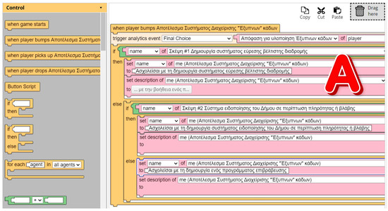
The Taleblazer platform allows individuals without programming knowledge to create functionality for their games using a visual programming language called Blocks. The blocks are divided into eight categories, with the user’s puzzle of blocks creating a logic similar to that of traditional programming languages (Figure 2). The game’s control, operators, game, looks, movement, traits, time, and Bluetooth technology categories of blocks are all designed to help users create and manage their game.
Figure 2. Taleblazer blocks programming language, (A) Sample code segment composed of blocks: the text in Greek refers to identifiers’ names and values assigned to them.
2.1.2. The Educational LBG ThesSmartCity
ThesSmartCity is an educational game that focuses on sustainable development, specifically, in waste management, in Thessaloniki, Greece. The game involves players interacting with fictional characters, gathering information, and making thoughtful decisions to achieve their goals (Figure 3). To win the game, players must choose a series of actions to create a comprehensive proposal to submit to the mayor, obtaining the key to the city. The game is designed to enhance critical thinking skills and encourage team discussions.
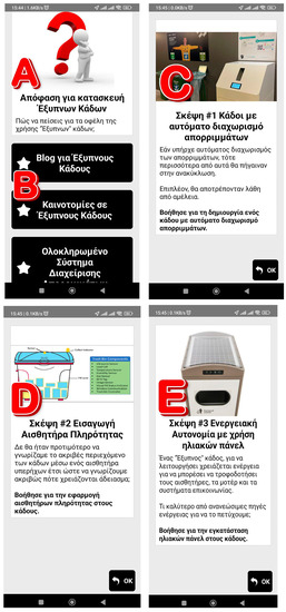
Figure 3. Taleblazer ThesSmartCity options, (A) The task assigned to the player in Greek, (B) Multiple choice question (C) Thought #1 (decision for achieving the task), (D) Thought #2, (E) Thought #3.
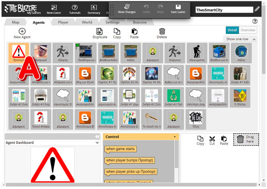
The game’s structural elements include a game region, a game introduction, 42 agents (Figure 4), nine different scenarios, 40 multimedia elements, one trait for each player, agent, and world, and one to five actions for each player, agent, and world. The game uses the scripting programming language “BLOCKS” to achieve interconnectivity between the game objects and smooth progression. The game was created in order to assess the capabilities of the Taleblazer tool in the development of LBGs.
Figure 4. Taleblazer ThesSmartCity agents (A) Agent with their names in Greek. Agents from left to right: Caution, Introduction, Instructions, Problem with trash bins, etc.
2.2. ARIS
2.2.1. The Main Features of ARIS
ARIS is a web-based, open-source platform that was developed by Field Day Lab (Figure 5). The platform can be used for educational and touristic purposes, as it allows the creation of fantasy games in which users may interact with real-world locations while learning information about them at the same time. Another advantage of this platform is that game developers may monitor players’ in-game actions and responses, which permits them to make amendments to the game.
Figure 5. ARIS Time Keepers web editor.
Some of the ARIS platform features can be found below:
-
Game development through the use of a drag-and-drop interface; no knowledge of programming is required.
-
Built-in scripting language for the creation of complex in-game interactions involving riddles and branching narratives.
-
Mobile app availability: The players can take advantage of the affordances of mobile devices, such as GPS technology, cameras, and sensors, since ARIS games are available on iOS mobile devices through the ARIS app.
-
Social interaction and collaboration during gameplay: Players achieve their goals through collaboration with other players, forming their own groups.
-
Customizable game features: Players construct their own avatars and virtual items and choose in-game locations.
-
Analytics: The platform offers analytics about game usage, player conduct, and progress.
-
Rewards: Points and badges are granted to players as rewards for goal achievement and task completion.
-
Game templates and scenarios: Players are given access to pre-set game templates and scenarios that they themselves can adjust to their preferences.
Nevertheless, the platform heavily relies on GPS technology, a fact that might cause accessibility problems in areas with low GPS accuracy. Another disadvantage may have to do with the relatively high level of technical expertise that the design of a game requires, which might prove discouraging and time-consuming for users.
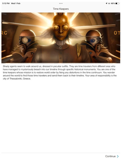
2.2.2. The Fantasy LBG Time Keepers
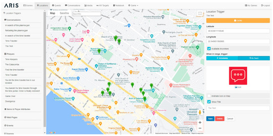
“Time Keepers” is an entertainment fantasy role-playing game (RPG) that involves decision making, interaction with fictional characters, and information collection (Figure 6). The game can be played several times, offering players a number of choices that will lead to three different endings and outcomes, which players are invited to explore in a hypertext fashion. The plot of the game revolves around a group of agents/guardians trying to send secret time travelers back to their timelines in order to prevent anomalies in the time continuum that will potentially lead to world-ending calamities and fatal changes in the course of human history. Historical monuments in the city of Thessaloniki, Greece, serve as portals with which players must interact in order to play the game (Figure 7).
Figure 6. ARIS Time Keepers—player interaction in the form of multiple choice questions.
Figure 7. ARIS Time Keepers player storyline.
There is a group of agents/guardians trying to send secret time travelers back to their timelines in order to prevent anomalies in the time continuum that will potentially lead to world-ending calamities and fatal changes in the course of human history. The players are introduced to the character “Anton”, the leader of the time guardians, who requires the players to pass a test to receive the time guardian’s badge. If the players answer incorrectly, the game ends. If they answer correctly, the next mission is to find a plasma gun to open a time portal and send the time travelers back to their timelines. The players must collect randomly generated plasma energy within a specific timeframe to charge the gun. Once the gun is charged, the players receive information that the targeted agent is near the Church of Hagia Sophia in Thessaloniki. After apprehending the agent, the players engage in a dialogue and must choose whether to exile the agent to their own timeline or allow them to stay, requesting that they cause no trouble. In the first case, the players open a time portal using the gun and exile the agent, while in the second case, the agent is left free to leave.
The “Time Keepers” game combines fantasy elements with historical aspects, guiding the players through various historical locations (Figure 8) in Thessaloniki. Players are required to fulfill various missions, such as plasma gun searches and refueling, that will result in sending them back to their era or permitting them to continue living in the current timeline with no repercussions for humanity.
Figure 8. ARIS Time Keepers locations.
The game resorts to the use of augmented reality (AR) and GPS technology, requiring the players’ exact location on the map.
2.3. Locatify
2.3.1. The Main Features of Locatify
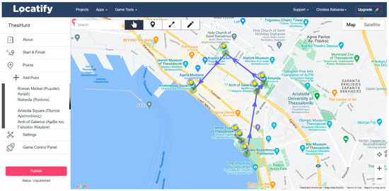
Locatify is a no-code platform that can be used to create indoor and outdoor location-based applications. As a no-code platform, it is ideal for users without programming skills. Locatify uses GPS and Bluetooth beacons to get an accurate position of its users. The platform is customizable on the user interface, map styles, and notification settings, although some are paid features. The interface is user-friendly (Figure 9), making the creation of applications a very easy process. Locatify is also very well documented, with many tutorials to help its users along their development process.
Figure 9. Locatify ThesHunt web interface.
The most important features of the Locatify platform (free version) are the following:
-
Customization: User interface, map styles, and notification settings can be customized according to the user’s needs. Some features are paid for though.
-
Real-time data: The platform supports real-time user location data, making the development of dynamic applications possible. This makes it ideal when people want to build more personalized applications.
-
Multilingual support: Locatify supports multiple languages, making it available to more users worldwide who can create applications in their local language.
-
Navigation: The platform can be used to create indoor and outdoor applications with the help of GPS and Bluetooth beacons.
-
Indoor mapping: Indoor applications were recently added to the Locatify platform, and they are ideal for museums, universities, and other buildings. They can provide guidance to users based on floor layouts.
-
Gaming: Locatify can be used for the creation of treasure-hunt games that engage users to explore the physical space and cooperate.
In conclusion, Locatify can be used for various projects, from tour guides to LBGs and, recently, indoor applications. People ought to mention that in the paid version, users have extended features and customization options.
2.3.2. The Treasure Hunt LBG Game ThesHunt
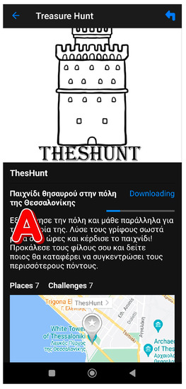
The Locatify platform offers three sections: Outdoor routes, treasure hunt games, and indoor projects. The “ThesHunt” game, based on Thessaloniki (Greece), combines entertainment and educational elements (Figure 10). It is available on iOS and Android devices through the “Turfhunt” application. The application supports audiovisual content and is accessible to people with disabilities, including visual impairments. It also features screen-reading features such as VoiceOver and TalkBack. The current availability of “Turfhunt” is limited, so it would be beneficial to expand it to more cities and provide regular updates to keep the game engaging.
Figure 10. Locatify ThesHunt game intro, (A) Description of the game in Greek.
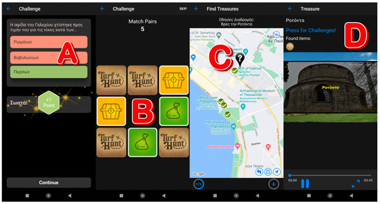
In the game, players select a nickname and a team and navigate through the designated map area to find objects, solve puzzles, and answer questions for points (Figure 11). The application promotes social interaction through playing with friends, forming groups, and sharing the scoreboard results on social media.
Figure 11. Locatify ThesHunt challenges, (A) Multiple choice question, (B) Match pairs game challenge, (C) Head to the next POI, (D) Descriptive video of the POI.
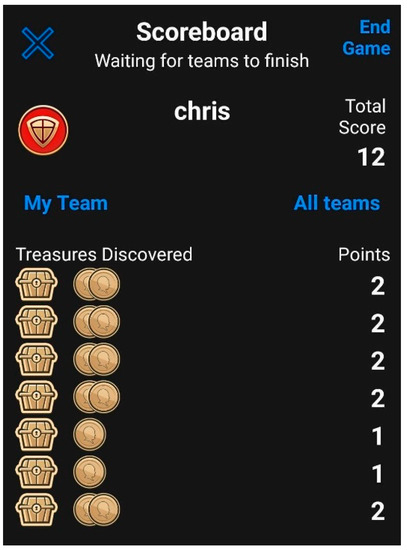
“ThesHunt” consists of 7 points of interest, 8 pictures, 7 challenges, and 3 multimedia files. The creation of the game consists of the following steps: Creation of a new project, adding instructions and information about the game, placing the points of interest on the map at specific locations, creating the challenges, adding multimedia content for each point of interest, adjusting the settings of the game, and publishing the game. At the end of the game, a scoreboard appears to display the achievements of a player or team, as seen in Figure 12.
Figure 12. Locatify ThesHunt scoreboard.
2.4. Actionbound
2.4.1. The Main Features of Actionbound
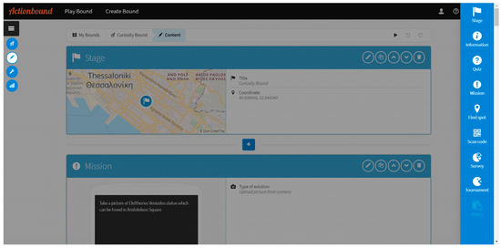
Actionbound is an easy-to-use, no-code platform for the creation of treasure hunts, surveys, and quizzes. The platform consists of a very intuitive drag-and-drop interface (Figure 13) that enables users to build applications with ease. Actionbound can be used to create educational as well as entertainment applications easily and quickly.
Figure 13. Actionbound Curiosity Bound web editor.
The Actionbound platform offers the ability to incorporate multimedia such as images, videos, and sounds inside the applications, providing a more immersive user experience. Another feature is the ability to create GPS missions where users need to physically travel to a given point in order to complete the mission. This is useful in cases such as treasure hunts, parks, and museums. Moreover, the platform has feedback and tracking capabilities, which are useful for educators to track the students’ progress. Actionbound is multilingual, making it ideal to cover a larger user base, and supports iOS and Android devices. The platform also offers a paid plan for those who want custom branding for their application, need useful analytics, and want no limit on the number of applications that they can create.
2.4.2. The Treasure Hunt LBG Game Curiosity Bound
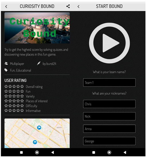
Facilitating the Actionbound platform, people created the “Curiosity Bound” treasure hunt game. The purpose of the game is not only entertaining but also educational. It does so by providing historical and cultural information about the city of Thessaloniki in Greece. Individuals or teams can play the game when they first choose a team and provide a nickname (Figure 14). To win, players/teams must complete the bound within a specific time set by the creator, and their ranking is displayed based on their score.
Figure 14. Actionbound Curiosity Bound game start.
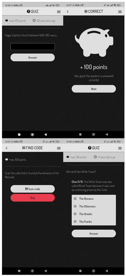
Apart from being entertaining, the game is also educational. Its objective is to entertain players while also acquiring cultural, historical, and encyclopedic knowledge about Thessaloniki. Players navigate through specific points of interest and solve various challenges to finish quickly and with a higher score than other players. Examples of game challenges can be seen in Figure 15.
Figure 15. Actionbound Curiosity Bound challenges.
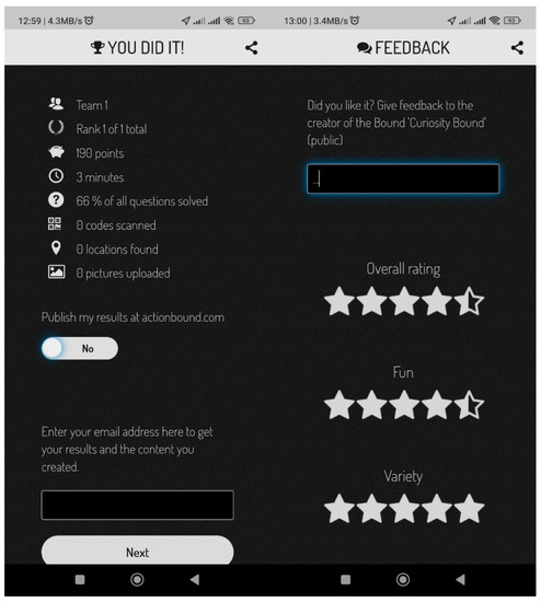
Teams start from a designated starting point. After reading the information provided through the “Info” element, players must answer the “Quiz” challenges correctly to earn as many points as possible within a limited time. In addition to the challenges, players are given “Missions” where there is no right or wrong answer. These missions can include tasks such as writing a text or uploading multimedia content. For example, players are asked to upload a photo of Eleftherios Venizelos, located in Aristotelous Square. Another type of challenge is finding a specific location based on coordinates, such as visiting the Church of Hagia Sophia. The game continues with successive pieces of information and challenges, and players are asked to scan a QR code located at the entrance of the Rotunda. The game ends with the display of achievements, scores, and a “Feedback” survey where players can evaluate the game (Figure 16).
Figure 16. Actionbound Curiosity Bound game over.
The game utilizes various elements provided by the Actionbound platform, including scenes, missions, location findings, information, quizzes, QR code scans, and surveys. These elements contribute to players’ scores, except for scenes, information, and surveys.