The digital twin can seamlessly integrate a multitude of sensor data sources, including field Internet of Things sensors, remote sensing data, field measurements, digital cartography, surveys, and other Earth observation datasets. By virtue of its duality, this digital counterpart facilitates data organisation and rigorous analytical exploration, unravelling the intricacies of physical, chemical, and biological soil constituents while discerning their intricate interrelationships and their impact on ecosystem services. Its potential extends beyond mere data representation, acting as a versatile tool for scenario analysis and enabling the visualisation of diverse environmental impacts, including the effects of climate change and transformations in land use or management practices. Beyond academic circles, the digital twin’s utility extends to a broad spectrum of stakeholders across the entire quadruple helix, encompassing farmers and agronomists, soil researchers, the agro-industry, and policy-makers. By fostering collaboration among these stakeholders, the digital twin catalyses informed decision-making, underpinned by data-driven insights. Moreover, it acts as a testbed for the development of innovative sensors and monitoring frameworks, in addition to providing a platform that can educate users and the broader public using immersive and innovative visualisation tools, such as augmented reality. This innovative framework underscores the imperative of a holistic approach to soil ecosystem monitoring and management, propelling the soil science discipline into an era of unprecedented data integration and predictive modelling, by harnessing the effects of climate change towards the development of efficient decision-making.
1. Introduction
Monitoring soil health is a paramount endeavour due to its pivotal role in sustaining both agricultural productivity and ecosystem vitality [
1,
2]. The significance of this practice extends beyond the realms of conventional farming, encompassing broader environmental concerns, global food security, and sustainable land use management [
3]; for example, the soil ecosystems serve as the bedrock for sustaining more than 90% of the world’s food supply [
4] and provide habitat for a substantial 25% of the planet’s total biodiversity [
5]. By comprehensively assessing soil health, researchers gain invaluable insights into the intricate web of interactions occurring within the soil matrix, including nutrient cycles, microbial communities, and physical structure. This knowledge, in turn, empowers end-users to make informed decisions to optimise crop yields, conserve natural resources, and minimise environmental impacts.
Nonetheless, the pursuit of accurate soil health assessment is not without its challenges, as traditional methods have proven to be limiting in their scope and precision, whilst there is not yet a single consensus on the definition of soil quality [
6]. Conventional techniques often involve time-consuming and labour-intensive processes that provide only a snapshot of soil conditions, failing to capture the dynamic and spatially heterogeneous nature of soils. Additionally, these methods may lack sensitivity in detecting subtle changes or emerging issues, thus impeding our ability to proactively address soil degradation, contamination, or shifts in fertility patterns. Moreover, traditional approaches can be cost-prohibitive when applied over large areas, hindering widespread adoption among farmers and land managers.
Recognising the threats that hinder soil health and taking into account that over 60% of the European soils are currently in an unhealthy state, the European Union with its “Soil Deal for Europe” aims to establish 100 living labs and lighthouses to lead the transition towards healthy soils by 2030 [
7]. Living labs act as real-life test and experimentation environments fostering co-creation and open innovation, involving all actors of the Quadruple Helix Model, i.e., academia, citizens, government, and industry. The success of such an endeavour necessitates the utilisation of capable models that can simulate all of the complex soil processes.
The concept of the digital twin has emerged as a powerful tool in various industries, aiming to facilitate actions such as real-time monitoring, data fusion, simulation, and projections and, overall, provide a holistic understanding of complex systems. It was introduced in 2013, but its definition has since evolved with no widespread consensus on the definition of various types of twins [
8,
9]. Nonetheless, in principle, a digital twin may be defined as a virtual representation of real-world entities and processes, synchronised at a specified frequency and fidelity [
10]. Its purpose is to enable measurements and simulations and act as a test bed for experimentation with a digital representation in order to better understand its physical counterpart, performing monitoring, analysis, and prediction. It requires both efficient and standardised data aggregation capacities and powerful data analytics. Digital twins have been employed, among others, in manufacturing [
11], smart cities [
12], and oil pipeline risk estimation [
13]. The integration of digital twins in agriculture, including soil monitoring, has been performed only at small scales (at the field level) [
14,
15,
16].
An interesting proposed implementation is the European Space Agency’s (ESA) Digital Twin Earth initiative, aiming to create a comprehensive digital replica of our planet, integrating Earth observation data, computational models, and advanced analytics [
17,
18]. It, thus, provides a means to better understand and manage Earth’s complex systems, including the atmosphere, oceans, and land and their interconnections. By harnessing the power of digital twins, ESA can gain valuable insights into climate change, natural disasters, resource management, and other crucial global challenges, helping to visualise, monitor, and forecast natural and human activity on the planet. The model will be able to monitor the health of the planet, perform simulations of Earth’s interconnected system with human behaviour, and support the field of sustainable development. It, thus, acts as a vital tool for decision-makers, scientists, and policy-makers, facilitating evidence-based decision-making, informed policy formulation, and proactive planning towards a sustainable future.
2. Cognitive Soil Digital Twin for Monitoring Soil Ecosystem
2.1. Digital Twin Technologies
Applications and different manifestations of the digital twin paradigm have been extensively reviewed in the literature in dedicated review papers [
9,
22,
23,
24,
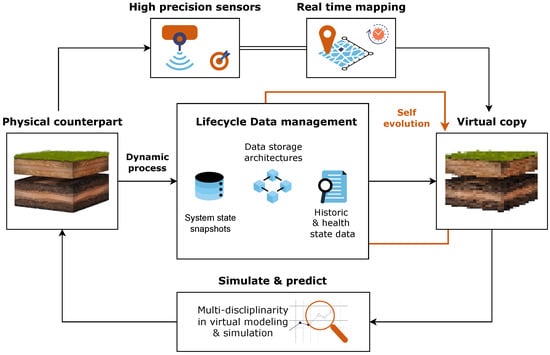
25]. In most cases, the following fundamental characteristics exist across the various implementations of the digital twin paradigm (
Figure 1):
Figure 1. The fundamental characteristics of a cognitive soil digital twin.
-
Real-time mapping of a physical entity with high fidelity: The digital twin must be a complete virtual copy of its physical counterpart, with high-precision sensors providing accurate measurements, which, in turn, enable the twin to simulate and predict the different system states.
-
Entire lifecycle data management: As the physical counterpart is dynamic, it is necessary to store the entire lifecycle data of the system, enabling functions such as historical state analysis, health analysis, and other data mining and analytical activities. Due to the high volume of such data, distributed data storage architectures must be considered. These elaborate analytical processes rely heavily on the data stored and managed throughout the system’s lifecycle, but empower the retrospective examination of the soil’s past conditions, which is essential for assessing the performance and health of the system over time.
-
Self-evolution: The digital twin should be able to adapt to changes and evolve; changes recorded in the physical counterpart ought to be reflected in the twin, with the data collected in real-time enabling the evolution and maturity of the twin in parallel with the physical counterpart. The self-evolution aspect also concerns the update of the various models and simulations when new data become available.
-
Multi-disciplinarity in virtual modelling and simulation: Different disciplines such as computer science, communications and automation and domain-specific knowledge (such as soil science in the case of the soil digital twin) must be fused to provide high-fidelity virtual modelling technologies. In effect, multi-domain data and knowledge coupled with multi-timescale and multi-dimensional information must be combined in order to provide accurate modelling and simulation.
2.2. Tools and Techniques for Soil Monitoring
Contemporary soil-monitoring and -mapping techniques encompass a variety of traditional tools that have been refined and augmented with modern technological advancements. Among the commonly employed methods is field sampling, where soil samples are collected at designated locations and depths for laboratory analysis [
26]. This technique provides essential information on soil properties such as pH, texture, organic matter content, nutrient levels, and cation exchange capacity [
27]. Additionally, soil spectroscopy techniques, such as visible–near-infrared (VNIR) and mid-infrared (MIR) spectroscopy, offer rapid and non-destructive means of assessing soil composition and properties based on the interaction of electromagnetic radiation with soil constituents [
28,
29]. Space-borne or air-borne remote sensing is also employed to provide detailed maps of soil properties [
30,
31,
32] or to assess land degradation [
33]. Another widely used technique is geophysical methods, including electrical resistivity [
34], electromagnetic induction [
35], and ground-penetrating radar [
36], which enable the estimation of soil properties by measuring variations in electrical or electromagnetic properties. Furthermore, sensor-based technologies, such as soil moisture sensors, temperature probes, and nutrient probes, allow for real-time monitoring of key soil parameters in the field [
37,
38]. The above notwithstanding, traditional techniques such as soil classification systems (e.g., Soil Taxonomy) [
39] and soil mapping using geostatistical approaches [
40,
41] continue to play a fundamental role in soil characterisation and mapping.
In addition to the traditional tools mentioned earlier, contemporary soil-monitoring and -mapping techniques encompass advanced tools that provide estimations of carbon sequestration or carbon stock [
42,
43,
44], the simulation of climatic scenarios or land use changes [
45], and other simulations crucial for understanding soil dynamics [
46]. One such tool is the RothC model [
47] employing carbon models and soil-carbon-mapping techniques, integrating field data, remote sensing data, and computational algorithms to estimate soil organic carbon stocks and changes over time. All these models help assess the potential of soils to sequester carbon and contribute to climate change mitigation strategies. Simulation models, such as ecosystem and agroecosystem models, simulate soil processes under different climatic scenarios, land management practices, and cropping systems. They provide insights into soil–water dynamics, nutrient cycling, crop growth, and carbon fluxes, allowing researchers to project future impacts and optimise land use strategies. Additionally, soil erosion models, such as the Universal Soil Loss Equation (USLE) or the Revised Universal Soil Loss Equation (RUSLE) [
48], simulate soil erosion processes and help identify areas prone to erosion, facilitating erosion control and soil conservation efforts. Moreover, hydrological models, such as the Soil and Water Assessment Tool (SWAT) [
49], simulate water movement, infiltration, and runoff in landscapes, aiding in water resource management [
50] and flood prediction. These advanced tools and simulations play a critical role in assessing the impacts of climate change, land management practices, and policy interventions on soil health, carbon dynamics, water resources, and overall ecosystem sustainability.
2.3. Limitations of Contemporary Approaches
The tools usually employed currently are associated with certain limitations. Evidently, the most-notable drawback is the lack of the integration of the multiple input data streams; oftentimes, approaches attempting to monitor the soil focus on one aspect (e.g., certain physicochemical properties) while neglecting the others (e.g., soil biodiversity) that are intertwined. Thus, this shortcoming lies in the scope of simulation and nowcasting capabilities offered by current tools: while they may provide estimations for specific soil properties or processes, they often fall short in simulating the entirety of ecosystem services associated with soils [
51]. Furthermore, these models employ different inputs that need to be prepared in advance, and due to the lack of one central repository, it is cumbersome to collect and standardise all necessary Earth observation input layers [
52]. Another limitation is the predominantly open-loop control nature of existing approaches. Traditional tools often provide one-time measurements or data collection, lacking the ability to continuously integrate and update information in real-time. Contrarily, if continuous monitoring, analysis, and feedback loops are employed, this can facilitate adaptive management strategies that respond to dynamic soil conditions. Finally, contemporary tools often lack the full utilisation of data analytics and advanced computational techniques. While data may be collected, the potential for extracting valuable insights and patterns through data analytics remains largely untapped.
2.4. Advantages of a Cognitive Soil Digital Twin
2.4.1. Real-Time Monitoring and Data Fusion
Digital twin technologies offer several advantages in terms of real-time monitoring and data fusion within the cognitive soil digital twin framework. Firstly, these technologies enable continuous real-time monitoring of ecosystem parameters, providing up-to-date and dynamic information about soil conditions. By seamlessly integrating disparate data sources, including Earth observation data, sensor networks, and IoT devices, the cognitive soil digital twin fosters a holistic understanding of ecological processes and dynamics. This real-time monitoring capability allows for a synchronisation between the physical entity and the digital twin, which, in turn, enables the timely identification of changes or anomalies in soil properties, enabling proactive decision-making and interventions. Additionally, the cognitive soil digital twin facilitates data fusion, which involves the integration and analysis of multiple data types and sources. By combining data from various sensors, models, and observations, the digital twin can generate a comprehensive and accurate representation of soil characteristics and behaviour. This data-fusion process enables researchers to uncover complex relationships and patterns, leading to deeper insights into soil processes, nutrient cycling, water dynamics, and other critical ecosystem functions. Furthermore, the real-time monitoring and data fusion capabilities of the cognitive soil digital twin support the generation of near-real-time or predictive models, allowing for proactive planning and management. By continuously assimilating new data and updating the models, the digital twin can provide timely and accurate predictions, empowering stakeholders to make informed decisions regarding soil management, crop growth, and environmental sustainability. This closed-loop control approach enables, furthermore, the continuous update of the models simulating the physical counterpart through techniques such as active learning.
2.4.2. Simulation and Scenario Analysis
Computational simulation has emerged as a crucial technique for analysis and decision-making support, demonstrating its significance in diverse sectors such as manufacturing, healthcare facilities, logistics, services, and more [
53]. The digital twin paradigm offers distinct advantages in the realm of simulation and scenario analysis within the soil science domain by providing a powerful platform for simulating a wide range of climatic scenarios and anthropogenic interventions, including agricultural practices such as tillage practices and crop rotation. By leveraging advanced AI/ML algorithms and integrating Earth observation data, these digital twin models possess the capability to predict and simulate ecosystem responses to various scenarios. Through the incorporation of comprehensive data inputs, such as soil properties, climate data, land use patterns, and management practices, digital twin models can generate valuable insights into the potential impacts and outcomes of different scenarios on soil health, crop productivity, and overall ecosystem dynamics. Moreover, the simulation and scenario analysis capacity of the digital twin enables researchers and decision-makers to assess the effectiveness of alternative strategies, optimise resource allocation, and design more-sustainable land management practices. By providing a virtual environment to explore and evaluate different scenarios, the digital twin becomes an invaluable tool for informed decision-making and proactive planning in the realm of soil science research and land management.
2.4.3. Policy Support and Environmental Management
The application of digital twin technologies to ecosystem monitoring provides a powerful tool for supporting environmental policies and management strategies. The soil digital twin, for instance, can significantly bolster policy support and environmental management efforts. By offering a comprehensive virtual representation of real-world soil ecosystems, the digital twin facilitates informed decision-making in multiple ways. Firstly, it allows policy-makers to simulate and assess the potential impacts of various policy interventions on soil health and quality. This predictive capability minimises the risk of unintended consequences and enables the formulation of well-informed, targeted policies that align with sustainability objectives.
Moreover, the soil digital twin’s ability to integrate real-time data from sensors and satellites ensures that policy recommendations are grounded in accurate and up-to-date information. This dynamic data-driven approach allows for adaptive management strategies that can respond to changing environmental conditions. Through simulation and scenario testing, policy-makers can assess the long-term implications of their decisions and fine-tune strategies for optimal outcomes.
Furthermore, the soil digital twin serves as a platform for collaboration and stakeholder engagement. It enables policy-makers, researchers, and local communities to interact with the virtual representation of the ecosystem, fostering a shared understanding of complex soil interactions and dynamics. This collaborative approach enhances the feasibility of implementing policies by garnering support from diverse stakeholders.
In essence, the soil digital twin acts as a bridge between scientific insights and policy implementation. Its capabilities encompass scenario exploration, data integration, and stakeholder engagement, all of which contribute to evidence-based decision-making and the achievement of the European environmental goals [
7]. As a versatile and powerful tool, the soil digital twin empowers policy-makers to navigate the intricate landscape of soil ecosystem management with precision and purpose, thereby propelling sustainable environmental practices forward.
This entry is adapted from the peer-reviewed paper 10.3390/soilsystems7040088