Monitoring and decision support within a smart city platform entails the utilization of technological tools to gather and analyse data from diverse sensors and information sources dispersed across the urban environment. The data gathered encompass several aspects, such as traffic patterns, air quality measurements, noise pollution levels, energy usage, and other related factors. The term digital twin (DT) has become very popular in recent years. DT is a critical technology that enables digital transformation in the industry to digitize physical assets. Digital representation of physical assets can allow opportunities to develop new business models or acquire broad ideas. Today, there is hardware that uses Augmented Reality (AR) technology that enables the adoption of new ways of human–machine interaction and information visualization in various use cases.
1. Digital Twin Construction
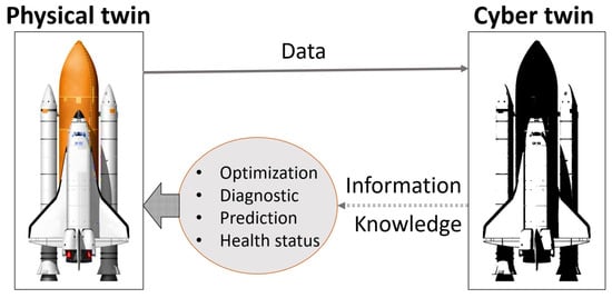
The researchers have provided many definitions of the digital twin (
Figure 1). Digital twins are defined by Grieves and Vickers, the two pioneers of the concept, as a set of virtual information constructs that completely describe the manufactured physical product from the micro-atomic level to the geometric macro level. A digital twin is (1) a digital representation of a physical object or process and (2) the establishment of a connection between digital and physical realms to exchange data and information. It exists for real-time monitoring, diagnostics, and prediction, as well as optimizing its dynamic behaviour and keeping tabs on the health of its physical twin [
29,
30].
Figure 1. Digital Twin Concept [
29].
A physical twin might be a process, a person, a location, an apparatus, or a thing used for a specific purpose. In addition, it is possible to create a digital twin of that, either a limited-function digital twin or a full digital twin that includes the entire behaviour of its physical counterpart [
29]. Manufacturing, healthcare, transportation, business, and academia are just a few examples of sectors where digital twins might be used; they could even be used as a novel energy-efficiency solution [
20,
31].
The primary purpose of the digital twin is to interact with its physical counterparts in the real world. The digital twin can track the current state of a physical object, establish its ideal state, predict its likely future state, and remotely make necessary adjustments to its physical location. In order to specify and mimic the state and behaviour of references to objects that do not yet exist in the actual world, digital twins can be constructed before the usage phase. Afterwards, the digital twin will continue to exist and may be used to archive information about situations that no longer exist in the real world [
32,
33].
2. Maturity Level for Digital Twin
Digital twins have a maturity spectrum, so that with this levelling the effectiveness of the resulting digital twin platform can be mapped (Table 1).
The maturity levels above can guide in determining the needs of the digital twin-based platform. In order to attain a mature level of digital twin implementation, it must be supported by a strong infrastructure. Digital twins require infrastructure that enables the successful use of IoT and data analytics, making digital twins run effectively and according to the goals set [
17].
3. Smart City Based on Digital Twin
Creating digital twins is seen as a new paradigm for building smart cities. With cutting-edge innovations like the Internet of Things (IoT), big data, cloud computing, and artificial intelligence (AI), smart city infrastructure has progressed from static 3D modelling to the hybrid of dynamic digital technology and static 3D models known as the digital twin. This circumstance gave rise to the idea that digital twins facilitate building of smart cities [
34].
The digital twin of a smart city is distinguished by four main features: accurate mapping, virtual–real interaction, software definition, and intelligent feedback. Accurate mapping means that digital twin cities realize comprehensive digital modelling of urban roads, bridges, buildings, and other infrastructure. The digital twin can control sensors in the air, ground, underground, and rivers in physical cities to monitor the city’s operating status and finally form accurate information. Interaction between the virtual and the actual world allows for searching various traces, including those left by individuals and the logistics and cars seen in the actual city. A software definition of a smart city indicates that it is based on a virtual representation of an actual city and uses software to mimic urban residents, activities, and infrastructure. On the other hand, intelligent feedback is an early warning of unintended consequences, conflicts, and urban dangers that may be achieved by means such as strategic planning, design, simulation, and others [
34].
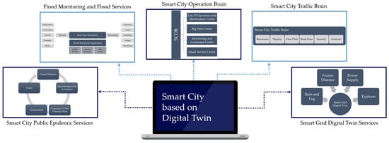
In one study, the use of digital twin technology in smart cities can be in the form of city operational management, traffic management, public services, flood monitoring, and other city operations. In
Figure 2, several smart cities based on digital twins are illustrated. The application of digital twins in smart cities can be in the form of city operational management in the form of a smart city operation brain. Officials from the city will take the primary roles in the Smart City Operation Center (SCOC), and they could also designate a Chief Operating Officer (COO). The Smart City Operation Brain (SCOB) management structure is modelled after the digital twin city. SCOB’s primary roles include (1) planning and assessing the general objectives, frameworks, tasks, operations, and management mechanisms of information development across different sectors; (2) contributing to and reviewing the city’s overall design; (3) creating applicable rules, regulations, and benchmarks; (4) overseeing the city’s information resource integration and sharing; (5) keeping an eye on the city’s operations, coordination, and unified command; and (6) advocating for an open, big-data-based ecosystem of socially focused products and services [
34].
Figure 2. Smart City based on digital twin.
Furthermore, the application of digital twins can also be a smart city traffic brain. Smart traffic systems can be built using holographic technology, time-space analysis, and data mining. The system is designed to integrate dynamic, real-time multinetwork and information traffic resources and connect them with various platform resources such as city alarm systems, police, road condition systems, accident emergency systems, and traffic video systems and display them into the same interface. As for the monitoring function, the digital twin can be applied to flood monitoring and flood services. Three components comprise smart cities’ flood monitoring and service apps: big data for flood monitoring, flood maps, and flood service applications. In the context of IoT and with real-time monitoring technology that combines space, air, and earth, flood monitoring big data refers to the monitoring technique of gathering vast quantities of data on flood catastrophes in real-time from an urban and watershed scale. The smart grid digital twin services involve a simulation procedure incorporating comprehensive physical models, real-time measurement data, and historical operational data from power generation systems. Additionally, it integrates diverse disciplines, including electricity, computer science, communication, climate studies, and economics. Smart city public epidemic services can be developed by utilizing various technologies such as cloud data platforms, analytic systems, response systems, and user terminals [
34].
4. Digital Twin for Simulation
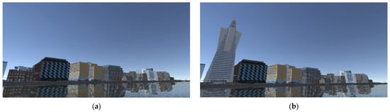
The application of digital twin technology in a city can also be in the form of simulating the condition of a city. The simulations carried out include simulations of the construction of skyscrapers, simulations of green spaces, flood simulations, and simulations of congestion. Based on the simulations carried out, the community can provide input on the simulations carried out, whether they agree or not if the simulation conditions are realized in the real world. Here is an example of a simulation that has been circumvented [
9]:
Figure 3 shows that section (a) is the current condition of a city, while section (b) is the condition of the city if there is a new building in the terse-but location. Based on this visualization, the community can provide input or opinions on whether to agree with or disagree with the proposed conditions based on the simulation results. Opinions from the community can be input for local governments to make decisions regarding the direction of urban development policies.
Figure 3. Building construction plan simulation [
9]: (
a) current digital twin; (
b) proposed building digital twin.
Other simulations can also be completed to simulate floods, congestion, and other problems commonly occurring in a city. Accurate simulations should be backed up with accurate and comprehensive data and information. Without all of these, it is not easy to carry out simulations that are accurate and complete by the conditions of the city. Inaccurate simulations will also result in mistakes in giving opinions or input, impacting decision-making errors.
This entry is adapted from the peer-reviewed paper 10.3390/su151814002